
Title: The Elements of Geology; Adapted to the Use of Schools and Colleges
Author: Justin R. Loomis
Release date: January 13, 2013 [eBook #41840]
Most recently updated: October 23, 2024
Language: English
Credits: Produced by Thomas Cosmas. Produced from files made
available on The Internet Archive and a physical copy of
the book.
THE
ADAPTED TO THE USE OF
SCHOOLS AND COLLEGES.
BY
JUSTIN R. LOOMIS,
PROFESSOR OF CHEMISTRY AND GEOLOGY IN WATERVILLE COLLEGE.
WITH NUMEROUS ILLUSTRATIONS.
BOSTON:
GOULD AND LINCOLN,
59 WASHINGTON STREET.
1852
Entered according to Act of Congress, in the year 1852,
By GOULD & LINCOLN,
In the Clerk’s Office of the District Court of the District of Massachusetts.
Stereotyped by
HOBART & ROBBINS,
BOSTON.
PRESS OF G. C. RAND, CORNHILL, BOSTON.
In preparing the following work, it was intended to present a systematic and somewhat complete statement of the principles of Geology, within such limits that they may be thoroughly studied in the time usually allotted to this science.
A sufficient number of leading facts has been introduced to enable the learner to feel that every important principle is a conclusion to which he has himself arrived; and yet, for the purpose of compression, that fullness of detail has been avoided with which more extended works abound. In furtherance of the same object, authorities are seldom cited.
The consideration of geological changes is made a distinct chapter, subsequent to the one on the arrangement of materials. It should, however, be remembered that these processes of arranging and disturbing are not thus separated in time. In nature the two processes are always going on together.
It seemed important to exhibit the science with as much unity and completeness as possible; and hence, discussions [iv] upon debatable points in Theoretical Geology, so interesting to mature geologists, would have been out of place here; and yet those more intricate subjects have not been omitted. A large proportion of the work is devoted to the explanation of geological phenomena, in order to convey an idea of the modes of investigation adopted, and the kind of evidence relied on. Where diversities of opinion exist, that view has been selected which seemed most in harmony with the facts; and the connection has not often been interrupted to combat, or even to state, the antagonist view.
Technical terms have, in a few instances, been introduced, and principles referred to, which are subsequently explained. The index will, however, enable the student to understand them, without a separate glossary.
Some may prefer to commence with the second chapter, deferring the study of the elementary substances, minerals and rocks, to the last. Such a course may be pursued without special inconvenience.
Questions have been added, for the convenience of those teachers who may prefer to conduct their recitations by this means. But, when the circumstances of the case admit of it, a much more complete knowledge of the subject will be acquired by pupils who are required to analyze the sections, and proceed with the recitation themselves; while the teacher has only to correct misapprehension, explain what may seem obscure, and introduce additional illustrations.
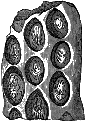
| 1. | Columnar Trap, New Holland. (Dana.) | ||||
| 2. | The four divisions of rocks, and their relative positions. A, Volcanic Rocks. B, Granite. 1, 2, 3, 4, Granite of different ages. C, Metamorphic Rocks. D, Fossiliferous Rocks. (Lyell.) | ||||
| 3. | Granite veins in slate, Cape of Good Hope. (Hall.) | ||||
| 4. | Granite veins traversing granite. (Hitchcock.) | ||||
| 5. | Extinct volcanoes of Auvergne. (Scrope.) | ||||
| 6. | Lava of different ages, Auvergne. (Lyell.) | ||||
| 7. | Strata folded and compressed by upheaval of granite. | ||||
| 8. | Favosites Gothlandica. | ||||
| 9. | Catenipora escharoides. (Chain coral.) | ||||
| 10. | Caryocrinus ornatus. (Hall.) | ||||
| 11. |
|
||||
| 12. | Section of a chambered shell, showing the chambers and the siphuncle. | ||||
| 13. | Orthoceras. [6] | ||||
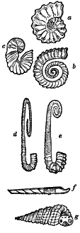
| 14. | Curved Cephalopoda, a, Ammonite; b, Crioceras; c, Scaphite; d, Ancyloceras; e, Hamite; f, Baculite; g, Turrilite. (Agassiz and Gould.) | ||||
| 15. | Trilobite. | ||||
| 16. | Cephalaspis Lyellii. (Agassiz.) | ||||
| 17. | Pterichthys oblongus. (Agassiz.) | ||||
| 18. | Fault in the coal formation, a a, layers of coal, b b, surface and soil. | ||||
| 19. | Stigmaria ficoides; Newcastle. (Lindley and Hutton.) | ||||
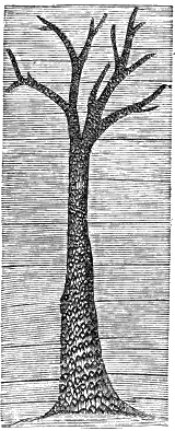
| 20. | Trunk of sigillaria. (Trimmer.) | ||||
| 21. | Bark of sigillaria. (Natural size.) | ||||
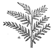
| 22. | Sphenopteris crenata. (Lindley.) | ||||
| 23. | Pachypteris lanceolata. (Brongn.) | ||||
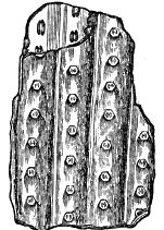
| 24. | Sigillaria levigata. (Brongn.) | ||||
| 25. | Lepidodendron Sternbergii, Bohemia. (Sternberg.) | ||||
| 26. | Calamite. | ||||
| 27. | Heterocercal fish. Homocercal fish. | ||||
| 28. | Impressions of Raindrops, Wethersfield, Conn. (Hitchcock.) | ||||
| 29. | b, Bird tracks in the Conn. River Sandstone, a, Consecutive tracks; c, Track of Cheirotherium (probably a reptile), Penn. and Germany. | ||||
| 30. | Section in the Isle of Portland. (Buckland.) | ||||
| 31. | Apiocrinites rotundus, Bradford, Eng. (Miller.) | ||||
| 32. | Gryphea incurva. | ||||
| 33. | a, Outline of Ichthyosaurus; b, Plesiosaurus. | ||||
| 34. | Pterodactyle. | ||||
| 35. | a, Diploctenium cordatum; b, Marsupites; c, Salenia; d, Galerites; e, Micraster cor-anguinum. (Agassiz & Gould.) | ||||
| 36. | b, Belemnite. a, Restored outline of the animal to which it belonged. [7] | ||||
| 37. | Cerithium intermedium. | ||||
| 38. | Murex alveolatus. | ||||
| 39. | Conus concinnus. | ||||
| 40. | Nummulite. | ||||
| 41. | Outline of paleotherium. | ||||
| 42. | Outline of anoplotherium. | ||||
| 43. | Skeleton of the mastodon. | ||||
| 44. | Univalve with entire mouth. | ||||
| 45. | Univalve with notched mouth. | ||||
| 46. | Unimuscular bivalve. | ||||
| 47. | Bimuscular bivalve. | ||||
| 48. | Parallel planes of cleavage intersecting curved strata. (Sedgwick.) | ||||
| 49. | a b, A vein of segregation; c d, A dike. | ||||
| 50. | Faults and denuded strata. | ||||
| 51. | Vertical conglomerate. (Lyell.) | ||||
| 52. | Inclined strata in Dorsetshire, England. (Buckland.) | ||||
| 53. | Dip of strata. | ||||
| 54. | Axes and valleys in disturbed strata. | ||||
| 55. | Curved strata of slate, Berwickshire, Eng. (Lyell.) | ||||
| 56. | Folded strata. | ||||
| 57. | Slope of mountains. | ||||
| 58. | Europe at the Silurian epoch. (Guyot.) | ||||
| 59. | Europe at the tertiary epoch. | ||||
| 60. | Area of elevation and depression in the Pacific and Indian Oceans. (Darwin.) | ||||
| 61. | c c, Coral wall. (Trimmer.) | ||||
| 62. | c c, Coral wall above the sea-level; c′ c′, Second coral wall. | ||||
| 63. | Coral wall after partial subsidence. [8] | ||||
| 64. | Atoll. The coral wall only appearing. The original island entirely submerged. | ||||
| 65. | Remains of the temple of Jupiter Serapis, near Naples. | ||||
| 66. | Detached hills of old red sandstone, Rosshire, Scotland. (Lyell.) | ||||
| 67. | Section of denuded strata, Mass. (Hitchcock.) | ||||
| 68. | Grooved and striated surface of rocks. | ||||
| 69. | Artesian wells. | ||||
| 70. | Segregated masses in rocks. | ||||
| 71. | Columnar form taken by basalt on solidification. | ||||
| 72. | Layers of limestone now forming, San Vignone, Italy. (Lyell.) | ||||
| 73. | Erosion of rock by the action of the waves. | ||||
| 74. | Marine currents. | ||||
| 75. | Sediment deposited in horizontal layers. | ||||
| 76. | Section of greensand, Bedfordshire, Eng. (Lyell.) | ||||
| 77. | Glacier, with lateral and medial moraines, a a, Terminal moraines. | ||||
| 78. | Iceberg. | ||||
| 79. | Volcanic Eruption. (Trimmer.) | ||||
| 80. | Fractures produced by upheaval. | ||||
| 81. | Fossiliferous rock altered by contact with granite. | ||||
| 82. | Consecutive changes by which horizontal strata become vertical. |
| Page | |
| CHAPTER I. OF THE MATERIAL WHICH COMPOSE THE CRUST OF THE EARTH. |
|
| SECTION I.—ELEMENTARY SUBSTANCES, | 11 |
| SECTION II.—SIMPLE MINERALS, | 13 |
| SECTION III.—THE MINERAL MASSES WHICH FORM THE CRUST OF THE EARTH, | 16 |
| CHAPTER II. OF THE ARRANGEMENT OF THE MATERIALS WHICH COMPOSE THE CRUST OF THE EARTH. |
|
| SECTION I.—THE CLASSIFICATION OF ROCKS, | 21 |
| SECTION II.—THE PLUTONIC ROCKS, | 23 |
| SECTION III.—THE VOLCANIC ROCKS, | 25 |
| SECTION IV.—THE NON-FOSSILIFEROUS STRATIFIED (OR METAMORPHIC) ROCKS, | 30 |
| SECTION V.—THE FOSSILIFEROUS ROCKS, | 32[10] |
| SECTION VI.—FOSSILS, | 57 |
| SECTION VII.—THE TIME NECESSARY FOR THE FORMATION OF THE STRATIFIED ROCKS, | 63 |
| CHAPTER III. OF THE CHANGES TO WHICH THE CRUST OF THE EARTH HAS BEEN SUBJECTED. |
|
| SECTION I.—CHANGES WHICH HAVE TAKEN PLACE AT GREAT DEPTHS BELOW THE SURFACE, | 67 |
| SECTION II.—CHANGES IN THE MASS OF THE STRATIFIED ROCKS, | 68 |
| SECTION III.—CHANGES OF ELEVATION AND SUBSIDENCE, | 73 |
| SECTION IV.—CHANGES ON THE SURFACE OF THE EARTH, | 85 |
| SECTION V.—CHANGES OF CLIMATE, | 88 |
| SECTION VI.—ADVANTAGES RESULTING FROM GEOLOGICAL CHANGES, | 91 |
| CHAPTER IV. OF THE CAUSES OF GEOLOGICAL PHENOMENA. |
|
| SECTION I.—ATMOSPHERIC CAUSES, | 95 |
| SECTION II.—CHEMICAL ACTION, | 97 |
| SECTION III.—ORGANIC CAUSES, | 101 |
| SECTION IV.—AQUEOUS CAUSES, | 103 |
| SECTION V.—AQUEO-GLACIAL ACTION, | 120 |
| SECTION VI.—IGNEOUS CAUSES, | 127 |
OF THE MATERIALS WHICH COMPOSE THE CRUST OF THE EARTH.
SECTION I.—ELEMENTARY SUBSTANCES.
There are about sixty substances known to the chemist which are considered as elementary; but most of them are rarely met with, and only in minute quantities. A few of them are, however, so abundant, in the composition of the crust of the earth, as to render some attention to them necessary.
Oxygen is more widely diffused than any other substance. It is an ingredient of water and of the atmosphere, the former containing eighty-eight per cent., and the latter twenty-one. Nearly all rocks contain oxygen in combination with the metallic and metalloid bases, and the average proportion of oxygen which they contain is about forty-five per cent.; so that it will not differ much from the truth to consider the oxygen in the earth’s crust as equal in weight to all the other substances which enter into its composition.
Hydrogen occurs in nature principally in combination with oxygen, forming water. It is also an ingredient in bitumen and bituminous coal.
Nitrogen is confined almost entirely to the atmosphere, of which it forms four-fifths. It enters into the composition of some varieties of coal, and is sparingly diffused in most fossiliferous rocks.
One of the most important substances in nature is carbon. It constitutes the principal part of all the varieties of coal, as well as of graphite, peat and bituminous matter. A much larger amount [12] of carbon exists in the carbonic acid which is combined with the oxides of the metalloids and metals. The most abundant of these compounds is limestone, which contains about twelve per cent, of carbon.
In the neighborhood of volcanoes sulphur is found pure and in a crystalline form. It is a constant ingredient in volcanic rocks, and in several of the most important ores, particularly those of lead, copper and iron. The most abundant sulphate is gypsum, which contains twenty-six per cent, of sulphur. In small quantities it is widely diffused in rocks, and in the waters of the ocean.
Chlorine is found principally as an ingredient of rock-salt, which contains sixty per cent, of it, and of sea-water, which contains one and a half per cent.
Fluorine is found, though very sparingly, in nearly all the unstratified rocks. It forms nearly half of the mineral known as Derbyshire spar.
Of the metals, Iron is the only one that is found abundantly. It enters into the composition of nearly all mineral substances. It is generally combined with oxygen, and occurs less frequently as a carbonate or sulphuret. Of volcanic rocks it forms about twenty per cent. Its ores are sometimes found in the form of dikes or seams, having been injected from below; at other times, in the form of nodules or stratified masses, like other rocks of mechanical origin.
Manganese is likewise extensively diffused, but in very small quantity. The other metals are often met with, but their localities are of very limited extent.
Of the metallic bases of the earths and alkalies, Silicium is the most abundant. It generally occurs in the form of silex, which is an oxide of the metal. There are but few rocks in which it is not found in considerable amount.
Aluminium generally occurs as an oxide, in which form it is alumina. It is the base of the different varieties of clay and clay-slate. It is also a constituent of felspar and mica.
Potassium is an ingredient of felspar and mica, and hence is [13] found in all the primary and in most of the volcanic rocks, as well as in the stratified rocks derived from them.
Sodium is a constituent of a variety of felspar which is somewhat abundant in volcanic rocks. Its principal source is the extensive beds of rock-salt, and the same substance in a state of solution in the waters of the ocean.
Calcium constitutes about forty per cent, of limestone, and is an ingredient in nearly all igneous rocks. This metal, in the state of an oxide, is lime.
Magnesium is somewhat abundant, but less so than calcium. It is one of the bases of dolomite and magnesian limestone, and is an ingredient of talc and all talcose rocks.
The substances now enumerated constitute nearly the entire mineral mass of the crust of the earth. They may be arranged in the following order:—
I. NON-METALLIC SUBSTANCES.
| Oxygen. Carbon. |
Hydrogen. Sulphur. Fluorine. |
Nitrogen. Chlorine. |
II. METALS.
| Iron. | Manganese. |
III. METALLIC BASES OF THE EARTHS AND ALKALIES.
| Silicium. Sodium. |
Aluminium. Calcium. |
Potassium. Magnesium. |
These substances, chemically combined, form Simple Minerals.
All substances found in the earth or upon its surface, which are not the products of art or of organic life, are regarded by the mineralogist as simple minerals. About four hundred mineral species are known, and the varieties are much more numerous; but only a small number of them are so abundant as to claim the [14] attention of the geologist. An acquaintance with the following species is, however, necessary.
Quartz is probably the most abundant mineral in nature. It is composed wholly of silex. Its specific gravity is 2.65. It is the hardest of the common minerals, gives sparks with steel, scratches glass, and breaks into irregular angular fragments under the hammer. When crystallized, its most common form is that of a six-sided prism, terminated by six-sided pyramids. When pure, it is transparent or translucent, and its lustre is highly vitreous. The transparent variety is called rock crystal. When purple, it is amethyst. When faint red, it is rose quartz. When its color is dark brown, or gray, and it has a conchoidal fracture, it is flint. When quartz occurs in white, tuberous masses, of a resinous lustre and conchoidal fracture, it is opal. The precious opal is distinguished by its lively play of colors. Jasper is opaque, and contains a small per cent, of oxide of iron, by which it is colored dull red, yellowish red or brown. The light-colored, massive, translucent variety is chalcedony. The flesh-colored specimens are carnelian. When composed of layers of chalcedony of different colors, it becomes agate. Several of the varieties of quartz, such as amethyst, opal, carnelian and agate, are used to considerable extent in jewelry.
Felspar is composed of silex, alumina and potassa. It resembles quartz, but it is not as hard, cleaves more readily, and is not generally transparent. Its specific gravity is 2.47. Its lustre is feebly vitreous, but pearly on its cleavage faces. Its color is sometimes green, but generally dull white, and often inclined to red or flesh-color.
Mica is composed of the same ingredients as felspar, together with oxide of iron. Its specific gravity is nearly three. It is often colorless, but frequently green, smoky, or black. It may be known by its capability of division into exceedingly thin, transparent, elastic plates.
Hornblende is composed of silex, alumina and magnesia. Its specific gravity is a little above three. Its color is generally some [15] shade of green. When dark green or black, whether in a massive or crystalline state, it is common hornblende. When light green, it is actinolite. The white variety is tremolite. When it is composed of flexible fibres, it is asbestus; and when the fibres have also a silky lustre, it is amianthus.
Augite or Pyroxene has, till recently, been considered as a variety of hornblende. Its specific gravity is slightly different; its composition is the same, and in general appearance it is not easily distinguished from hornblende. It has, however, been made a distinct species, because its crystalline form is different.
Hypersthene is composed of silex, magnesia and oxide of iron. Its specific gravity is 3.38. It closely resembles hornblende. The lustre of its cleavage faces is metallic pearly. Its color is grayish or greenish black.
Talc is composed of silex and magnesia. Its specific gravity is 2.7. It resembles mica in its general appearance and in its lamellar structure, but it is easily distinguished from it by its plates being not elastic, and by its soapy feel. Its color is generally some shade of green. Soapstone is an impure variety of talc, of a light gray color, earthy texture, and is unctuous to the touch. Chlorite, another impure variety, is a dark green rock, massive, easily cut with a knife, and unctuous to the touch.
Serpentine is composed of silex and magnesia. Its specific gravity is 2.55. It is generally massive, unctuous to the touch, and of a green color. It is often variegated with spots of green of different shades. With a mixture of carbonate of lime it forms the verd antique marble.
Carbonate of Lime, or common limestone, is composed of carbonic acid and lime. Its specific gravity is 2.65. It presents a great variety of forms. In a crystalline state it is generally transparent, and when so, possesses the property of double refraction. It may be distinguished from every other common species by its rapid effervescence with acids. It readily cleaves parallel to all the faces of the primary form, which is a rhombohedron.
Sulphate of Lime, or Gypsum, is composed of sulphuric acid [16] and lime. Its specific gravity is 2.32. When crystalline, it has a pearly lustre, is transparent, and goes under the name of Selenite. Common Gypsum resembles the other earthy limestones, but it is softer, and may be readily distinguished by its not effervescing with acids.
To the minerals now enumerated may be added the following, which are of frequent occurrence, but not in great quantities; namely, carbonate of magnesia, oxide of iron, iron pyrites, rock-salt, coal, bitumen, schorl and garnet.
These simple minerals, either in separate masses or mingled more or less intimately together, compose almost wholly the earth’s crust.
SECTION III.—THE MINERAL MASSES WHICH FORM THE CRUST OF THE EARTH.
That portion of the structure of the earth which is accessible to man is called the crust of the earth.
The mineral masses which compose it, whether in a solid state, like granite and limestone, or in a yielding state, like beds of sand and clay, are called rocks.
The unstratified rocks are Granite, Hypersthene rock, Limestone and Serpentine, and the Trappean and Volcanic rocks.
Granite is a rock of a light gray color, and is composed of quartz, felspar and mica, in variable proportions, confusedly crystallized together. The felspar is generally the predominant mineral. It is sometimes of a very coarse texture, the separate minerals occurring in masses of a foot or more in diameter. At other times it is so fine-grained that the constituent minerals can scarcely be recognized by the naked eye; and between these extremes there is every variety. The term granite is not, however, confined to an aggregate of these three minerals. In some instances the felspar so predominates as almost to exclude the other minerals, when it is called felspathic granite. When the quartz appears in the form of irregular and broken lines, somewhat resembling written [17] characters, in a base of felspar, it is called graphic granite. When talc takes the place of mica, it is talcose granite. When hornblende takes the place of mica, it is syenite. Granite or any rock becomes porphyritic when it contains imbedded crystals of felspar.
There is a rock of crystalline structure, like granite, but of a darker color, which is called hypersthene rock. It is composed of Labrador felspar and hypersthene. The mineral species serpentine and limestone often occur unstratified in considerable quantities.
Volcanic rocks consist of the materials ejected from the craters of volcanoes. They are composed of essentially the same minerals as trap rocks. When the material has been thrown out in a melted state, it is called lava. Lava, at the time of its ejection, contains a large amount of watery vapor at a high temperature. Under the immense pressure to which it is subjected in the volcanic foci, it may exist in the form of water; but when the lava is thrown out at the crater, the pressure cannot much exceed that of the atmosphere. The particles of water at once assume the gaseous form. As lava possesses considerable viscidity, the steam does not escape, but renders the upper portion of the mass vesicular. This vesicular lava is called scoriæ. By the movement of the stream of lava, these vesicles become drawn out into fine capillary tubes, converting the scoriæ into pumice-stone.
A large part of the materials ejected from volcanoes is in the form of dust, cinders and angular fragments of rock. These soon become solidified, forming volcanic tuff, or volcanic breccia. In submarine eruptions these fragments are spread out by the water into strata, upon which other materials, not volcanic, are afterwards deposited. These interposed strata are called volcanic grits.
The trappean rocks are composed of felspar, mingled intimately and in small particles with augite or hornblende. They also contain iron and potassa. They are often porphyritic. When they contain spherical cavities, filled with some other mineral, such as chlorite, carbonate of lime or agate, they are called amygdaloidal trap.
The principal varieties of trappean rock are basalt, green stone, and trachyte. In basalt, augite, or, in some cases, hornblende, is the predominant mineral. It is a heavy, close-grained rock, of a black or dark brown color. Greenstone differs from basalt in containing a much larger proportion of felspar. Its structure is more granular, and frequently it assumes so much of the crystalline form as to pass insensibly into syenite or granite. It is a dark colored rock, with a slight tinge of green. Both green stone and basalt are disposed to assume the columnar form, the columns being arranged at right angles to the faces of the fissure into which the trap is injected. When it is spread out into broad horizontal masses, the columns are vertical. (Fig. 1. Trachyte is composed principally of felspar, is of a grayish color, and rough to the touch.
Of the stratified rocks the following are the most important:
Gneiss is a rock closely resembling granite. It is an aggregate of the same minerals, but the proportion of mica is somewhat greater. The only distinction between them is that the gneiss is stratified, but the stratification is often so indistinct that it passes insensibly into granite. Generally, however, the stratification is so distinct as to present a marked difference.
Mica slate is such a modification of gneiss that the mica [19] becomes the predominant mineral, with a small intermixture of quartz and felspar. Consequently the stratification becomes very distinct, so as sometimes to render the mass divisible into thin sheets. The stratification is often wavy, and sometimes much contorted.
Sandstone consists of grains or fragments of any other rock, but more frequently of siliceous rocks. The fragments are consolidated, sometimes without any visible cement, but often by a paste of argillaceous or calcareous substance. The color varies with that of the rock from which it was derived. Generally, however, it is either drab or is colored red by oxide of iron. The fragments are sometimes so minute as scarcely to give the rock the appearance of sandstone. When they are of considerable size and rounded, the rock is called conglomerate. When they are angular, it is called breccia. Greensand is a friable mixture of siliceous and calcareous particles, colored by a slight intermixture of green earth or chlorite.
Limestone is a very abundant rock, and occurs in many different forms. In transparent crystals it is Iceland spar. When white and crystalline, it is primary limestone, saccharine limestone, or statuary marble. When sub-crystalline it is generally more or less colored. It is often clouded with bands or patches of white in a ground of some dark color. When its texture is close, and the crystallization scarcely apparent, it is compact limestone. The white, earthy variety is chalk. A variety of limestone composed of small spheres is called oölite. Lias is the name given to an impure argillaceous variety of a brown or blue color. Any rock which contains a considerable proportion of carbonate of lime, and which rapidly disintegrates on exposure to the atmosphere, is called marl. Limestone sometimes contains carbonate of magnesia. It is then magnesian limestone, or dolomite.
Clay consists of a mixture of siliceous and aluminous earth. It is tough, highly plastic, and generally of a lead blue color. It is always stratified, and often divided into very thin laminæ, which [20] are separated by sprinklings of sand only sufficient to keep them distinct.
Clay slate, or argillaceous schist, is composed of the same materials as clay, and differs from it only in having become solidified. Its color is gray, dark brown or black. In some beds it is purple. Shale is the same material in a state of partial solidification. On exposure to the weather, it soon disintegrates, and is finally reconverted into clay. All the varieties of argillaceous rock are easily distinguished by a peculiar odor which they emit when breathed upon.
Argillaceous slate sometimes takes into its composition portions of some other mineral, such as talc, mica, or hornblende. When any of these minerals becomes so abundant as to constitute a considerable part of the mass, the rock becomes talcose, micaceous, or hornblende slate. Sometimes this last variety loses all appearance of a fissile structure, and is composed almost wholly of hornblende. It is then called hornblende rock.
Diluvium is the name applied to masses of sand, gravel, and large rocks, called boulders, heaped confusedly together on the surface of the earth. It is also called drift.
OF THE ARRANGEMENT OF THE MATERIALS WHICH COMPOSE
THE CRUST OF THE EARTH.
SECTION I.—THE CLASSIFICATION OF ROCKS.
In the first place, we divide rocks into stratified and unstratified. This division is one which will in general be easily recognized, even by the most inexperienced observer; and the distinction is important, because it separates the rocks of igneous origin from those which have been produced by deposition of sediment from water.
It will be shown hereafter that a part of the unstratified rocks have been formed at or near the surface of the earth; that is, they have taken their present form by passing from a state of fusion to a solid state above or between the stratified rocks, as in the case of lava (Fig. 2, A). The other unstratified rocks have cooled so as to take the solid form below the stratified rocks, as at B. The first are called epigene, or volcanic rocks; the last, hypogene, or plutonic rocks.
The lowest portion of the second division, the stratified rocks, are termed non-fossiliferous, from the fact that they contain no evidence of the existence of organic beings at the time when they were deposited. Their relation to the other rocks is shown at C. It is supposed that these rocks have been subjected to great changes by heat from the igneous rocks below them. On this account Mr. Lyell proposes to call them metamorphic rocks. The other portions of the stratified rocks are fossiliferous, containing the remains of organic beings which lived at the period when the rocks were deposited. They are represented at D. The division of the last-named rocks info groups will be given hereafter.
We have then four principal classes of rocks: Plutonic Rocks, Volcanic Rocks, Non-fossiliferous Stratified Rocks and Fossiliferous Rocks.
SECTION II.—THE PLUTONIC ROCKS.
Granite is by far the most important of this class of rocks. Of its thickness no estimate can be made, as no mining operations have ever penetrated through it, and none of the most extensive displacements of rocks by natural causes has brought to the surface any other rock on which it rests. It may, therefore, be considered the foundation rock, the skeleton of the earth, upon which all the other formations are supported. The whole amount of granite in the earth’s crust may be greater than that of all other rocks, but it comes up through the other formations so as to be exposed over only a comparatively small portion of the surface, and this is generally the central portion of mountain ranges, or the highest parts of broken, hill country. Still, it is not unfrequently found in the more level regions, in the form of slightly elevated ridges, with the stratified rocks reclining against it.
The structure of granite seems frequently to be a confused mixture of the minerals which compose it, without any approach to order in their arrangement; but in many cases it is found to split freely in certain directions, and to work with difficulty in any other. This may result from an arrangement of the integrant crystals, so that their cleavage planes approach more or less nearly to parallelism. When this is the case with the mica or felspar, it must diminish the cohesion in a direction perpendicular to these planes, and thus facilitate the cleavage of the mass.
Granite is found to penetrate the stratified rocks in the form of veins. The following section (Fig. 3) will show the relation of granite veins to the granitic mass below. The granite which is quarried for architectural purposes is often in comparatively small quantities, disappearing at the distance of a few hundred yards beneath the stratified rock; or else it exists in the form of isolated dome-shaped masses. It is probable that, if they could be followed sufficiently far, they would be found to be portions of dikes coming from the general mass of granite below. Even the granite nuclei of the great mountain ranges may be considered as injected dikes of enormous magnitude.
Granite is itself intersected with granite veins more frequently, perhaps, than any other rocks; but the vein is a coarser granite than the rock which it divides. It is not uncommon to find one set of dikes intercepted and cut off by a second set, and the second by a third. The substance of the dikes was, of course, in a liquid state when it was injected, and the first must have become solid before the second was thrown in; hence the dikes are of different ages. The dikes a b c, represented in Fig. 4, must have been injected in the order in which they are lettered.
It is probable that, by the process of cooling, the liquid mass from which these dikes have proceeded has been gradually solidifying from the surface downwards. If so, it would follow that the granite nearest the surface (1, Fig. 2) is the oldest, and the newest is that which is at the greatest distance below (4). It is possible that at great depths granite may be still forming, that is, taking the solid form, though of this there can be no direct [25] proof. There is, however, proof that it has been liquid at periods of time very distant from each other; for the dikes sometimes reach to the top of the coal formation (for example), and then spread themselves out horizontally, as at a, showing that the rock above the coal had not then been deposited. Another dike will extend through the new red sandstone, as at b, and spread itself out horizontally as before. These horizontal layers of granite, by their position in strata whose ages are known, indicate the periods when granite has existed in a liquid state. Granite veins have been discovered in the Pyrenees as recent as the close of the cretaceous period, and in the Andes they have been found among the tertiary rocks.
There are several other rocks, of minor importance, often found in connection with granite. Hypersthene rock, in a few cases, forms the principal part of mountain masses. Greenstone is more frequently associated with the trappean rocks, but it sometimes passes imperceptibly into syenite and common granite. Limestone is found in considerable abundance, and serpentine in small quantities, as primary rocks, and have evidently been formed like granite, by solidifying from a state of fusion.
SECTION III.—THE VOLCANIC ROCKS.
The volcanic rocks consist of materials ejected from volcanoes. They are, however, ejected in very different states; sometimes as dust, sand, angular fragments of rock, cinders, &c., and sometimes as lava streams. In some instances, the lava has so little fluidity that it accumulates in a dome-shaped mass over the orifice of eruption, and perhaps in a few instances it has been thrust upward in a solid state.
There are two principal varieties of lava, the trachytic, consisting mostly of felspar, and the basaltic, consisting of hornblende. When both kinds are products of the same eruption, the trachytic lava is thrown out first, and the basaltic last. The reason of [26] this is, that felspar is lighter than hornblende, and probably rises to the surface of the lava mass at the volcanic focus, and the basaltic lava is therefore reserved till the trachytic has been thrown off.
These, like other rocks, have been produced at different epochs. There is, however, great difficulty in determining their age; There are some differences of structure and composition observed, in comparing the older and newer lavas; but the only method that can be relied on to determine their age is their relation to other rocks. When they occur between strata whose age is determined by imbedded fossils, they must be of intermediate age between the inferior and superior strata.
1. Modern Volcanic Rocks.—Some of the volcanic rocks are of modern origin, and are produced by volcanoes now active. The total amount of these, and of all the other volcanic rocks, is probably less than that of either of the other principal divisions of rocks; yet they form no inconsiderable part of the earth’s crust. The number of active volcanoes is not far from three hundred, and the number of eruptions annually is estimated at about twenty. In some cases, the lava consists of only a single stream, of but a few hundred yards in extent. It extends, however, not unfrequently twenty miles in length, and two or three hundred yards in breadth. The eruption of Mount Loa, on the island of Hawaii, in 1840, from the crater of Kilauea, covered an area of fifteen square miles to the depth of twelve feet; and another eruption of the same mountain, in 1843, covered an area of at least fifty square miles. The eruption in Iceland, in 1783, continued in almost incessant activity for a year, and sent off two streams in opposite directions, which reached a distance of fifty miles in one case, and of forty in the other, with a width varying from three to fifteen miles, and with an average depth of more than a hundred feet. The size of some of the volcanic mountains will also assist in forming an idea of the amount of volcanic rocks. Monte Nuovo, near Naples, which is a mile and a half in circumference and four hundred and forty feet high, was thrown up in a single day. Ætna, which is eleven thousand feet high, and eighty-seven miles in circumference at its [27] base, has probably been produced wholly by its own eruptions. A large part of the chain of the Andes consists of volcanic rock, but the proportion we have not the means of estimating.
2. Tertiary Lavas.—There is another class of volcanic products, which are so situated with reference to the tertiary strata that they must be referred to that period. The principal localities of these lavas, so far as yet known, are Italy, Spain, Central France, Hungary, and Germany. They are also found in South America. Those of Central France have been studied with the most care. They occur in several groups, but they were the seats of volcanic activity during the same epoch, and formed parts of one extensive volcanic region. Each of these minor areas, embracing a circle of twenty or thirty miles in diameter, is covered with hills two or three thousand feet in height, which are composed entirely of volcanic products, like the cone of Ætna. On many of them there are perfectly-formed craters still remaining. Numerous streams of lava have flowed from these craters, some of which can now be traced, throughout their whole extent, with as much certainty as if they were eruptions of the present century. Some of the lavas have accumulated around the orifices of eruption, forming rounded, dome-shaped eminences. These lavas generally consist of trachyte, and have therefore a low specific gravity, and imperfect fluidity. The basaltic lavas have often spread out over broad areas, and, when they have been confined in valleys, have reached a distance of fifteen miles or more from their source. There still remain indications of a current of lava which was thirty miles long, six broad, and in a part of its course from four to six hundred feet deep. The above sketch (Fig. 5) will give some idea of the highly volcanic aspect which the district of Auvergne, in France, presents.
The unimpaired state of some of the cones and craters, and of the lava currents, would lead to the impression that these regions have been the theatre of intense volcanic action within a very recent period. But there is good reason to believe that this has not been the case. “The high antiquity of the most modern of these volcanoes is indeed sufficiently obvious. Had any of them been in a state of activity in the age of Julius Cæsar, that general, who encamped upon the plains of Auvergne and laid siege to its principal city, could hardly have failed to notice them.”
It is equally certain that the commencement of their activity was at a late period in the history of the earth. Lava currents are frequently found in France resting upon the early tertiary strata, but no lava current is found below them. The later tertiary strata contain pebbles of volcanic rocks, showing that lavas had been previously ejected, but none are found in the older strata of this formation. We must, therefore, conclude that these volcanic tracts assumed their volcanic character at some intermediate point in the tertiary period.
When we find that their activity commenced at so late a period and closed so long ago, we might be led to suppose that it was of very short duration. But a great number of facts, in the present condition of the country, require that we should assign to them a very prolonged activity. A single instance will be sufficient to show the nature of the evidence upon which this conclusion rests. The heavy line (Fig. 6) represents the present form of one of the valleys. A bed of lava forms the highest point of land represented, and a second bed is found in an intermediate part of the slope. The position of the upper bed must have been a valley, when the lava flowed there. We may represent this valley by the line a b c. The slow operation of natural denuding causes at length excavated the valley d e h, when another lava current flowed through it, covering its bed of pebbles, as before. The same denuding causes have at length produced the present valley, f g h. [29] These remnants of lava-currents, as they have formed a very imperishable rock, have protected the subjacent strata from erosion, and furnish evidence of the position of the valley at different periods. When we consider with what extreme slowness denuding causes produce changes on the surface, and what extensive changes they have here nevertheless effected in the interval between the production of the different lava currents, we are compelled to feel that that interval was a very prolonged one. Yet this period, however long it may have been, was evidently less than the period of activity of these volcanoes.
3. Volcanic rocks of an earlier date are also found, sometimes as distinct lavas, though generally as volcanic grits. They occur interstratified with the cretaceous rocks, and with every other formation of the fossiliferous series, showing that, from the earliest times, these rocks have been accumulating as they now are.
The trappean rocks may, in a general classification, be considered as volcanic. It will be shown, hereafter, that they are the lavas of submarine volcanoes. They do not, however, occur in the form of lava currents, but in great tabular masses, generally between stratified rocks, or in the form of dikes. They are also entirely unconnected with cones or craters.
The trappean rocks occur more or less abundantly in all countries. One of the most noted localities of this rock is a region [30] embracing the north of Ireland, and several of the islands on the western coast of Scotland. It contains the celebrated Giant’s Causeway, which consists of a mass of columnar trap; also Fingal’s Cave, which is produced by a portion of the trap being columnar, and thus disintegrating more rapidly than the rest, by the action of the waves. An immense mass of greenstone trap, which has generally been considered as a vast dike, though often a mile in thickness, is found extending from New Haven to Northampton, on the west side of the Connecticut river. It then crosses to the east side, and continues in a northerly direction to the Massachusetts line. Under different names, it constitutes a nearly continuous and precipitous mountain range for about one hundred miles. Dr. Hitchcock supposes this greenstone range to be, not an injected dike, but a tabular mass of ancient lava, which was spread out on the bed of the ocean during the period of the deposition of the Connecticut river sandstone. It was subsequently covered with a deposit of strata of great thickness, and then by subterranean forces thrown into its present inclined position.
There is a mass of basaltic rock in the valley of the Columbia river, in the Oregon Territory, which extends without interruption for a distance of four hundred miles. Its breadth and thickness is not known, but in some places the river has cut a channel in this rock to a depth of four hundred feet. Its age has not been determined, and it will, perhaps, be found to be a tertiary or modern production.
SECTION IV.—THE NON-FOSSILIFEROUS STRATIFIED (OR METAMORPHIC) ROCKS.
1. Gneiss is the most abundant rock in this class, and is generally found reposing on granite. Its stratification is sometimes very distinct, but it is often so imperfect that it can scarcely be recognized. This is more frequently the case in the vicinity of granite on which it rests, and into which it insensibly passes. A [31] large part of the material used for building purposes, under the name of granite, is obscurely marked gneiss. In all primary countries it is an abundant rock, occupying extensive districts, and sometimes forming mountain masses.
2. Mica slate lies next above gneiss, and is a very abundant rock. As it differs from gneiss only in the proportion of mica which it contains, and as the quantity of mica in it is very different in different places, it is often difficult to make the distinction between them. It also passes by insensible degrees into the argillaceous rocks. Many of the argillaceous rocks are found, upon close examination, to contain mica in minute scales in such abundance as to make it doubtful whether they ought not to be regarded as mica slates; that is, the metamorphic action by which argillaceous slate is converted into mica slate had proceeded so far, before it was arrested, that it becomes impossible to say whether the argillaceous or micaceous characters predominate.
3. Argillaceous slate.—The last rock of this series is a slaty rock, more or less highly argillaceous. It does not differ in lithological characters from the same rock in the higher strata. It is doubtful whether the roofing-slates should be considered as belonging to the metamorphic series or not. They have been subjected to a very high degree of metamorphic action, and yet strata intimately associated with them have, in occasional instances, contained fossils.
It is not easy to fix the exact upper limit of this series. The fossils are few, obscure, and seldom met with in the lowest fossiliferous series; and the transition is very gradual from the distinctly metamorphic to the fossiliferous rocks. This renders it impossible always to determine accurately the line of separation.
The gneiss, mica slate and argillaceous slate, have the order of superposition in which they are here named. They differ only in the amount of metamorphic action to which they have been subjected; and the gneiss which is most highly metamorphic has, by being the lowest, been most acted upon,—the mica slate less, and the argillaceous slate least. In a particular locality, however, the [32] lowest rock which was subjected to these causes of change, instead of having been of such a character as to produce gneiss, may have been a limestone, and in that case the lowest metamorphic rock would be a saccharine marble. In another locality the lowest rock may have been a sandstone, which would be converted into quartz rock. Hence there may occur, in any part of the metamorphic series, crystalline limestone, quartz rock, hornblende slate, chlorite slate, and talcose slate; and any one of these rocks may be as abundant in any particular region, as gneiss, mica slate or argillaceous slate, is in another.
The metamorphic rocks occur in all countries where there has been any considerable amount of volcanic action, and their total amount is very great; but their stratification is so confused and contorted, their superposition so irregular, and denudations have been so extensive, that no estimate can be made of their thickness. They are, perhaps, equal to all the other stratified rocks.
SECTION V.—THE FOSSILIFEROUS ROCKS.
The fossiliferous rocks are divided into seven systems, which are readily distinguished by the order of superposition, lithological characters and organic remains. These systems are the Silurian, the Old Red Sandstone, the Carboniferous, the New Red Sandstone, the Oölitic, the Cretaceous, and the Tertiary systems. There is also an eighth system now in process of formation.
It is the opinion of some geologists that there is another system situated between the metamorphic rocks and the silurian system. It has been called by Dr. Emmons, who has studied it with much care, the “Taconic System,” the Taconic Mountains, in the western part of Massachusetts, being composed of these rocks. It is the lower part of what has been called, in England and Wales, the Cambrian system.
The strata of this system have a nearly vertical position, and consist principally of black, greenish and purple slates, of great [33] thickness. Granular quartz rock, however, occurs in considerable quantity, and in this country two thick and important beds of limestone are found. These limestones are occasionally white and crystalline. Generally, however, as a mass, they are a dark, nearly black rock, with a network of lines of a lighter color. All the clouded marbles for architectural and ornamental purposes are from these beds, and our roofing and writing slates are all obtained from the argillaceous portion of this system.
The number of species of organic remains contained in this system is very small, and these, so far as discovered, belong to the annelida, with a few doubtful cases of mollusca. This system of rocks is found coming to the surface in a large part of New England, and the eastern part of New York, also in the western part of England and Wales.
Those geologists who deny the existence of this system consider these rocks as parts of the silurian system which have been most disturbed by subterranean forces, and most altered by proximity to igneous rocks. The annexed sketch (Fig. 7) will exhibit the relations here referred to. Certain portions of the silurian rocks are supposed to have been thrown into folds by the upheaval of the primary rocks. The plications nearest to the intrusive granite would be most altered. That part of the figure below the line a a represents the outcropping edges as they now appear, the upper portion of the folds having been removed by some abrading cause.
As it is yet uncertain which of these views is correct, convenience will justify us in retaining the name of Cambrian system till further investigations shall settle the question.
1. The Silurian System.—The following tabular arrangement exhibits the divisions of the system as recognized in England, in New York, in Pennsylvania and Virginia, and in Ohio.
This name, Silurian, was first used to designate the lowest well-characterized fossiliferous rocks in England. But it is now used to embrace the whole system as it occurs elsewhere. It is well exhibited in New York, both in consequence of its great development there, and because the whole system is only slightly acted upon by disturbing forces, so that the outcropping edge of each division extends over a large surface.
This system is of great thickness, amounting, in places where it is well developed, to twenty thousand feet.
The Champlain division commences with a quartzose sandstone, passing gradually into limestone, which is succeeded by a very thick argillaceous deposit, the Utica slate and Hudson River group. The Ontario division in the lower part is a mass of sandstone. Above this is the Clinton group, consisting of shales and sandstones. The most important part of this group, in an economical point of view, is a fossiliferous, argillaceous iron ore, coextensive with the group in this country, and is worked to supply a large number of furnaces. The last of the division is the Niagara group, which commences with a mass of shale, and becoming at length calcareous, it terminates in a firm compact limestone. This limestone has withstood the action of denuding causes better than the shales either above or below it. It therefore presents a bold escarpment at its outcrop, and occasions waterfalls wherever streams of water cross it. The falls of Niagara are formed by this rock. The Niagara limestone, in its extension westward, becomes the lead-bearing rock of Missouri, Iowa and Wisconsin. The Helderberg division is a succession of highly fossiliferous limestones, with the intervention of only occasional beds of grits and shales. One member of the series is the Onondaga Salt group. The water obtained from this group in New York annually furnishes immense quantities of salt. The Erie division consists of a thick mass of shales and sandstones.
|
||||
|
|
|||
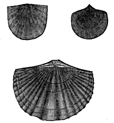
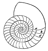
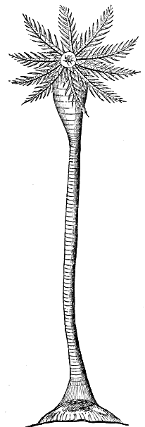
The fossils of this system are very numerous, but consist mostly of the lower forms of animal life. Corals (Fig. 8. and 9) are abundant, and constitute in some places a large proportion of the limestones. The Crinoidea, or lily-shaped animals, consist of a jointed stem permanently attached, and bearing at the free extremity of the stem an expanded portion, which is the pelvis, or digestive cavity. The mouth is surrounded with a series of leaf-like tentacula, which serve the purpose of seizing and holding food. Fig. 10 represents the pelvis of one of the silurian fossils. The general character of the animal is better represented by Fig. 30. The most abundant fossils of this period are the lowest orders of bivalve mollusca (Fig. 11). The Cephalopoda are characterized by having the organs of locomotion attached to the head. The shell of several species is peculiar in being divided into distinct cells, or chambers (Fig. 12, b d), perforated by a tube (siphuncle a). These fossil shells are sometimes straight, as the Orthoceras (Fig. 13), or [37] curved, as shown in the several forms of Fig. 14. The Trilobite was an articulated, crustaceous animal, having two lines along the back dividing it into three lobes, from which circumstance its name is derived. It is found in great numbers in the Silurian rocks (Fig. 15). In a few instances remains of fishes have been found, but they by no means characterize the system.
|

|
The geographical range of this system is probably greater than that of any system of rocks above it. It is found occupying a large part of the territory west of the Alleghany Mountains, from Canada, through New York, and the other states, to Alabama; and extending westward to and beyond the Mississippi river. It occupies a large district in the west of England, and is found in great force in the north and east of Europe.
2. The Old Red Sandstone.—This formation consists almost entirely of a sandstone of a red color. It admits of division into three parts, though the characters vary in different places. The lowest is a thin-bedded argillaceous sandstone, consisting of finely levigated material, and easily splitting into thin sheets. From this circumstance it has received the name of tilestone. The middle portion is composed of nodules or concretions of limestone imbedded in a paste of red sand and shale. This has been called by English geologists, cornstone, and though very partially developed in some regions where the system is found, it is yet a very persistent member. The highest member of this formation is a mass of red sandstone, often passing into a coarse conglomerate. In England the thickness of the Old Red Sandstone is not less than ten thousand feet. In this country it is scarcely three thousand feet.
The fossils of this system are a few shells, a small number of vegetable species, and in particular localities the remains of fishes in great abundance. The system is characterized principally by fossils of this last kind. The fishes of this system have a cartilaginous skeleton, but are covered with plates of bone, which were faced externally with enamel. The jaws, which consisted of solid bone, were not covered with integument. The exterior bony covering seems to have been the true skeleton, as is, in part, the case with the tortoise. In some of the fishes of this period there is a wing-like expansion on each side of the neck, which has given them the name of Pterychthis (Fig. 17). In others, as the Cephalaspis, the plate of bone on the back is so large as to cover nearly the whole body, and make it resemble a trilobite (Fig. 18).
This system has an extensive geographical range. In England, it occupies a band of several miles in width, extending from the Welsh border northward through Scotland to the Orkney Islands. In this country, it forms the Catskill Mountains, in New York, and extends south and west so as to underlie the coal-fields of Pennsylvania and Virginia.
3. The Carboniferous System.—This system consists of three parts, distinguished by lithological and fossil characters.
The carboniferous limestone is a dark-colored, compact limestone, forming the base of the system, and reposing on the old red sandstone. Its thickness is from six hundred to one thousand feet, often with scarcely any intermixture of other rock; but it sometimes loses its character of a limestone, and becomes a sandstone,[40] or conglomerate. It generally contains the ores of lead in considerable quantity, and from this circumstance has been called metalliferous limestone. In England it is the principal repository of these ores. In the Western States it is the upper portion of the lead-bearing strata.
The fossils are marine, and very numerous. Corals and crinoidea are very abundant. The crinoidea, in some localities, form so large a part of the rock as to have given to it the name of encrinal limestone. The orthoceras and trilobite are found, but become extinct with this formation. Several species of bivalves, such as Delthyris and Leptæna, are also common.
Next above the limestone lies the sandstone, sometimes called millstone grit. It is generally drab-colored, but occasionally red. Its thickness is often equal to that of the limestone. Sometimes [41] it is fine-grained and compact; but generally it is coarse-grained, and often passes into a conglomerate. It contains but few fossils, and those of vegetable origin.
The highest part of the system is the coal measures. They consist of beds of sandstone, limestone, shale, clay, ironstone and coal, occurring without much uniformity in their order of superposition. The coal measures have a thickness of about three thousand feet. The sandstones and limestones are not distinguishable from the sandstones and limestones in the lower part of the system. The ironstone either occurs in concretionary nodules, often formed around some organic nucleus, or it is an argillaceous ore, having a slaty structure. In either case, it consists of subordinate beds in the shale. The coal consists of several beds distributed through the measures. The beds vary in thickness from a few lines or inches to several feet. In a few cases beds have been found measuring fifty or sixty feet in thickness. The workable beds are ordinarily from three to six feet thick.
The carboniferous formation is very much disturbed by dikes, faults (Fig. 18; see also Fig. 50), and other dislocations. The amount of change of position in the strata, by faults, is very various; frequently but a few feet. In one case in England there is a fault of nearly a thousand feet. There is a case of dislocation in Belgium where the strata are bent into the form of the letter Z, so that a perpendicular shaft would cut through the same bed of coal several times.
The characters and order of superposition which have now been given may be regarded as the general type of the carboniferous formation. There are, however, several important modifications. 1. Beds of coal sometimes alternate with beds of millstone grit. [42] Thus, in Scotland and in the north of England, this intermediate member of the system disappears, or, rather, is incorporated with the coal measures. The same is true, to considerable extent, in this country. 2. Sometimes the carboniferous limestone also disappears as a distinct member of the system, partly by becoming arenaceous, and partly by the intercalation of beds of coal. In this last case, the whole formation from the old to the new red sandstone becomes a series of coal measures. In this country the carboniferous limestone is found very generally to underlie the coal strata. 3. The fractures and faults, which were formerly supposed to be characteristic of the coal formation, are seldom found in the great coal-fields of this country, except in those of the anthracite coal of Pennsylvania; and even there they are much less common than in the coal-fields of Europe.
There are three principal varieties of coal, distinguished by the different proportions of bitumen which they contain. The common bituminous coal kindles readily, emits much smoke, and throws out so much liquid bitumen that the whole soon cakes into a solid mass. It contains about forty per cent, of bitumen. The second kind, or cannel coal, contains twenty per cent., and inflames easily, but does not agglutinate. The stone-coal, or anthracite, contains scarcely any bitumen, ignites with difficulty, emits but little smoke, and produces a very intense heat. The bituminous varieties are always found in the least disturbed portions of the coal districts; and the anthracite is found in the more broken and convulsed portions, where we may suppose that the subterranean heat has been sufficient to drive off the volatile bituminous part, and reduce it to the anthracite form. Hence the eastern Pennsylvania coal-fields, which lie near the principal axes of elevation of the Appalachian Mountains, furnish only anthracite; while the same coal-seams, in their extension to the western part of the state, are bituminous.
Where coal is quarried in large quantity, a shaft is sunk through the overlying strata to the coal-beds, and the coal is raised to the surface by steam power. After the coal has been quarried to some [43] distance from the shaft, pillars of unquarried coal are left to support the overlying strata. Fatal accidents have sometimes occurred by the giving away of these supports. Over a large part of the coal-fields of the United States it has not yet become necessary to sink shafts. The quarrying is commenced at the outcrop of the coal-bed; and, till the cover becomes of considerable thickness, it has been found economical to “strip” off the overlying rock, rather than to work a subterranean gallery.
Brine-springs are often found in the coal measures of sufficient strength to be used in the manufacture of salt. This is now done to considerable extent in Ohio. In the valley of the Kenhawa river, Kentucky, the rocks of which belong to the carboniferous system, the brine is nearly saturated with salt; and in some of the borings they have even discovered beds of rock-salt of great thickness and purity.
There is no other part of the geological series so obviously connected with national prosperity as the coal formation. While a country is new, the forests furnish an abundant supply of fuel; but in the course of a few years these are consumed. This country will soon be principally dependent upon its coal-mines for fuel, even for domestic purposes; and, in carrying on the great branches of national industry, such as the smelting and working of iron, and in the formation of steam for the purposes of manufacture and transportation, we are already mainly dependent upon mineral coal. A nation which does not possess an abundant supply of this mineral, or which does not use it, cannot long maintain a high degree of national prosperity.
In these inexhaustible masses of coal, accumulated ages before the existence of the human race, is a most obvious prospective arrangement for securing our happiness and improvement. And this arrangement embraces not only the accumulation of a combustible material in such abundance, but also its juxtaposition with an equally inexhaustible accumulation of iron ore, and the limestone which is necessary as a flux in the reduction of the ore. So bulky and heavy materials as coal and iron ore could neither of them [44] have been transported to any considerable distance for the manufacture of iron; and without the manufacture of iron on a large scale, the present operations in manufactures and transportation could never have been entered upon. A large proportion of the iron furnaces in this country, and nearly all of them in Great Britain, employ mineral coal for fuel, and obtain their ore from the beds contained in the coal measures.
The fossils of the coal measures are almost entirely of vegetable origin, and are very abundant. They are seldom found in the coal-beds, but in the strata of shale immediately above or below the solid coal.
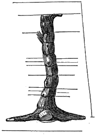
The Stigmaria (Fig. 19) is found most abundantly, and in a large proportion of cases to the exclusion of every other form, in the lower shales. It consisted of a large dome-shaped mass, often [45] three or four feet in diameter, with trailing branches, or roots, spreading off horizontally to a distance of twenty feet. In a few instances tree ferns have been found, petrified in a horizontal position, and being apparently a mere continuation of the stigmaria. Hence the stigmaria has been supposed to be the base of the tall tree ferns, the leaves of which so abound in the upper shales. If this is not the case, there are no forms of the existing flora of the earth analogous to the stigmaria. It is always found in connection with the coal-beds of the carboniferous formation, and never with the coal-beds which sometimes occur in the later formations.
|
|
The tree ferns (Fig. 20) attained a height of fifty or sixty feet, and a diameter of four feet. They have received the name of Sigillaria in consequence of the seal-like impressions (Fig. 21) with which the surface is covered, and which are the scars left where the fronds have fallen off. These fronds (fern leaves) are the most abundant fossil of the series. They are distinguished by some peculiarity in form, as the Sphenopteris (wedge-shaped fern leaf), Pachypteris (thick fern leaf), &c. (Fig. 22. and 23.)
There was another kind of Sigillaria (Fig. 24), in which the surface was fluted, and the markings are superficial, and occur on the ridges. It reached as great a size as the tree ferns, but to what general class of plants it belonged is still doubtful.
|

|
|
|
The Lepidodendron (scale-covered tree) (Fig. 25) is the fossil which most nearly resembled in general appearance our present [47] forest trees. Specimens are found four feet in diameter and seventy feet in height. In botanical characters it resembled, in some respects, the trailing club-mosses, while in others it was very similar to the Norfolk Island pine.
The Calamite (Fig. 26) was a plant resembling, in its jointed and striated surface, the equisetum (rush), but was sometimes twelve inches in diameter.
The carboniferous formation exists more or less abundantly in all the great divisions of the earth. It occurs in nearly all of the countries of Europe. The largest deposits known are, however, in the United States; especially in the States of Pennsylvania and Virginia, and in Ohio.
4. The New Red Sandstone.—The lower division of this formation, called the Permian system, consists of a thick mass of sandstones, generally of a red color, with occasional alternations of argillaceous rock, succeeded by a series of magnesian limestones. The upper division, or Triassic system, is composed of a red conglomerate, a limestone which has received the name of Muschelkalk (shelly limestone), and a series of variegated marls and sandstones.
The ores of copper are found, to considerable extent, in this formation. The rich copper mines of Germany are in the magnesian limestone, or, as it is there called, Zechstein (minestone). The Lake Superior copper mines occur in a red sandstone formation, which will probably be found to belong to this system.
The salt-beds, salt springs, and beds of gypsum, are so, generally found in this rock in England, that it has been called by the English geologists the “saliferous system.” It is, however, found that in other countries these minerals occur in equal abundance in formations of an earlier and later date.
The fossils of this system are not abundant. In the Permian portion, impressions of fishes are found, always with the peculiarity that the tail is heterocercal (Fig. 27); that is, with the spine continued into the upper lobe. The same peculiarity prevails in the carboniferous and all the earlier formations. Fishes with the tail homocercal begin to appear in the Triassic portion of this system, and are found in all the subsequent formations. The remains of saurians also occur in this formation.
The red sandstones seem to have been better adapted to retain the forms which were impressed upon them than to preserve the organic remains which were deposited in them. Hence, while they contain but few fossils, the strata are often covered with ripple marks, with sun cracks, occasioned by contraction while drying, or with depressions produced by rain-drops, and the pits are [49] sometimes so perfect as to show the direction of the wind when the drops fell. (Fig. 28. The tracks of animals are also well preserved. Some of them were produced by reptiles (Fig. 29, c), and some probably by marsupial animals, but most of them by birds (a, b). President Hitchcock has distinguished the tracks of more than thirty species in the sandstones of the Connecticut valley. Birds, reptiles and marsupial animals, seem to have been first introduced during this period.
The new red sandstone is well developed in all its members on the continent of Europe. In England, all the members are present, except the Muschelkalk. The Triassic portion of it occurs in North America. It is found in detached portions, probably as parts of a continuous formation, in Nova Scotia, the eastern part of Maine, the Connecticut valley, and from New Jersey southward through Pennsylvania, Maryland, &c., to South Carolina.
5. The Oölitic System.—The lower portion of this system is the Lias, and consists of a series of fissile, argillaceous limestone, marl, and clays. The Oölite forms the intermediate member of the system, and consists of alternations of clay, arenaceous rock and limestone. Some of the limestones have an oölitic structure, and the whole system takes its name from this circumstance, though this structure is not found in all parts of it, and is often found in other formations. The central part of the oölite, the coral rag, is principally a mass of corals and comminuted shells. The Wealden, the highest member of the oölitic system, is an estuary deposit, consisting of calcareous beds, followed by sandstone, and terminated by the Wealden clay.
This system is throughout highly calcareous, and furnishes, wherever it is developed, valuable materials for architectural and ornamental purposes.
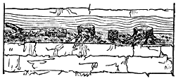
This system is distinguished for the great amount and variety [50] of its organic remains. The vegetable productions were intermediate between those of the coal period and those of the present time. The upper oölite, in the south of England, contains the stumps of trees and other plants, rooted in a black carbonaceous layer, evidently the soil from which they grew. These stumps and prostrate trunks are the remains of coniferous trees of large growth. (Fig. 30.)
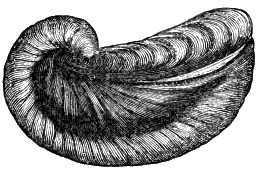
Corals occur in great abundance; also encrinites (Fig. 31), mollusks (Fig. 32), and cephalopoda.
|
|
|
But this system is specially characterized by the remains of saurian reptiles. The Ichthyosaurus (Fig. 33, a) was a marine animal, having the general form of a fish, while its head, and especially its teeth, resemble those of the crocodile. [51] It was an air-breathing animal like the cetacea, and was furnished with similar paddles. It was carnivorous, and was undoubtedly the largest and most formidable animal existing in the earlier part of the oölitic period. Its length could not have been less than thirty or forty feet.
The Plesiosaurus (Fig. 33, b) was also a marine animal, and in ninny respects similar to the Ichthyosaurus; but its general form was more slender, its head was small, and its neck was of great length, the cervical vertebræ exceeding in number those of the swan.
The Pterodactyle (Fig. 34) was a small saurian, of the size, probably, of our largest eagle. The finger-bones, which in the other saurians form the paddles, are in the Pterodactyle very much lengthened, so as to support a membranous expansion, like that of the bat. These wings were of sufficient size to enable it to sustain itself in the air, and to make a rapid and easy flight.
The Iguanodon is a Wealden fossil, remarkable for its great magnitude. It is estimated that its length was seventy feet. It was a lizard, adapted for motion on land, and was herbivorous.
This formation is well developed in England, and, with the exception of the Wealden, on the continent of Europe. It has been supposed that no part of the oölitic series was to be found in this country; but there is a highly arenaceous rock occupying the valley of the James river, in the vicinity of Richmond, Virginia, of considerable extent, and a thousand feet in thickness, containing [52] a bed of coal of forty feet in thickness, which, from its fossils, must be referred to the oölitic series.
6. The Cretaceous Formation.—The lower part of this formation consists of greensand, interstratified with beds of clay. The intermediate portion is a mixture of argillaceous greensand and impure chalk. The upper part is composed of chalk, which is a friable, nearly pure carbonate of lime. The strata of chalk are separated, at intervals of from three to six feet, by layers of flint, either in the form of nodules or of continuous strata.
These characters, by which the cretaceous system is known in England, are but partially recognized elsewhere. Thus, in the Alps, the “Neocomian System,” consisting of crystalline limestones, is the equivalent of the English greensand; while the greensand of this country is the equivalent of the white chalk of England.
The fossils of the cretaceous formation are very different from those of the oölite, and are such as to show that it was deposited in deep seas. Microscopic shells are often so abundant as to constitute a large proportion of the mass. Zoöphytes are very numerous, such as sponges, corals, star-fishes (Fig. 35, d e), and a few crinoidea (b). Mollusks were also abundant, and cephalopoda, consisting of chamber-shells and belemnites (Fig. 36). The belemnite probably resembled the existing cuttle-fish; but the remains consist, in most cases, of a partially hollow calcareous substance (b), which was contained within the animal, and formed its skeleton.
The chalk and greensand are largely developed in England; [53] and the same formation, with different lithological characters, is found in great force flanking the principal mountain ranges of southern Europe, and extending into Asia. In this country the system commences with the greensand and friable limestones of New Jersey, and following the Alleghany range to its southern termination, it bends around into a north-western direction, and is continued into Missouri.
7. The Tertiary System.—The tertiary strata embrace the formations from the cretaceous to the human era. They consist of clay, sand, sandstone, marl and limestone, and are distinguished from the lower rocks by being less consolidated; though the limestones are in some instances solidified, and resemble the strata of earlier origin. The tertiary strata are generally of less thickness than the older formations, and less continuous, being local deposits formed in lakes and estuaries. In a few instances they have been thrown into inclined positions, though in most cases they have been but slightly disturbed, and raised but a few hundred feet above the present level of the sea.
The late tertiary strata seldom overlap the older, so as to indicate their relative ages by superposition. They have therefore been separated into groups according to the proportions of living and extinct species of shells which they are found to contain. The oldest tertiary or Eocene formation[A] contains only four per cent, of living species, the Miocene contains seventeen per cent., the Pleiocene forty per cent., and the Pleistocene ninety per cent.
[A] Eös, dawn, and kainos, recent. The formation which commenced at the dawn of the recent period, containing but a small number of living species. Miocene (meion, less), less recent than the Pleiocene (pleion, more). Pleistocene (pleistos, most), most recent.
During the pleistocene period, peculiar conditions existed, by which a great amount of loose material, known by the name of drift, was spread over the northern portions of both hemispheres. In America it is found from Nova Scotia nearly to the Rocky Mountains, and extending as far south as Pennsylvania and the Ohio river. In Europe, it is found from the Atlantic to the Ural [54] Mountains, and reaching south into Germany and Poland. It is also found in the colder portions of South America, and in the vicinity of several mountains, as the Alps.
It consists of irregular accumulations of earthy substances of different degrees of fineness, but characterized by containing masses of rock of considerable size, often of many tons weight, called boulders. Rocks having the same lithological characters exist in situ north of where the boulders and other drift are now found, though at a distance often of one or two hundred miles. There can be no doubt but that the drift has been transported from these northern localities; and the polished, striated and grooved condition of the rocky surface, wherever the drift is distributed, has obviously been produced by the passage of the drift materials over it.
Towards the close of this period, while the land was a few hundred feet below its present level, there were deposited in the valleys of the drift region beds of blue and gray clay, materials which are used in making bricks and coarse pottery; also beds of sand, sometimes evenly spread out, but often thrown into irregular mounds and ridges.
In regions which are not covered with drift,—as the south of Europe and the United States,—the pleistocene deposits are succeeded, without apparent change of conditions, by those which are now taking place.
The formations of the tertiary period are distinguished from those of the cretaceous period by the absence of deep-sea fossils, and from the oölite by the absence of its characteristic saurians. The mollusks are also very different, such genera as the cerethium (Fig. 37), murex (Fig. 38), and conus (Fig. 39), which abound in the present seas, first appearing in the tertiary period. The nummulite (Fig. 40), a peculiar form of chambered shell, is so abundant as to constitute in some places almost the entire rock.
The period is however characterized by the existence of a large number of pachydermatous animals, of which the tapir, hog, horse and elephant, are examples of living species.

|

|

|

|
The Paleotherium (Fig. 41) resembled, in most respects, the tapir. It was furnished with a short proboscis, and the foot was divided into three toes. The length of the largest species was about that of the horse; but its body was larger, and it was of less height.
The Anoplotherium (Fig. 42) was a more slender animal, and resembled in size and general form the gazelle.
The Megatherium, an animal of the late tertiary epoch, was larger than the existing species of elephant, and in its general structure and habits resembled the sloth.
The Mastodon (Fig. 43) lived during the latest portion of the tertiary epoch. Its remains are found most abundantly where the animal seems to have perished by sinking into the soft marshy [56] ground near the brackish springs of New York and Kentucky. But they are found also in Europe and Asia. It was larger than any existing land animal, and was nearly allied in structure and habits to the elephant.
The Mammoth was a species of elephant, now extinct, of which remains are found with those of the mastodon, but in the greatest abundance in Europe and Asia. A large number of skeletons, many of them imperfect, have been discovered in the low grounds in the south-east of England. It was this animal which was found encased in ice and sand in Siberia, in 1804.
Contemporaneously with the existence of these huge animals, a near approach was made to the present fauna of the earth, by the introduction of ruminant animals resembling the ox and deer, and especially by the existence of the class of animals which in anatomical characters stands next to man, the apes and monkeys.
The tertiary system, though not generally so continuous over extended areas as the older formations, yet constitutes the surface of a very large part of Europe. (See Fig. 59.) In the United States the earlier portion is found along the seaboard, from New Jersey to Louisiana, and extending back towards the mountains to a distance varying from ten to one hundred miles. The later [57] deposits are found in detached portions throughout the Eastern and Middle States. It covers a large surface in South America, and is found in India.
8. The Recent Formation.—It is intended to embrace in this term strata which have been formed since the creation of man. It is, however, impossible to separate them by any well-defined characters from those of the tertiary period. The recent formation consists of land which is forming by the filling up of lakes, and by the increase of deltas from the accumulated sediment which rivers have furnished.
There is, however, no doubt but that formations on a large scale have continued in progress over extensive areas of the bed of the sea; and they have been no less rapid, we may presume, than they were in earlier periods. But, though they are preserving the records of the present era, they will probably remain in a great measure inaccessible for many ages.
These deposits, so far as they are accessible, are found to contain the remains of plants and animals (including man) now living in the vicinity where the deposits are forming.
Any organic substance imbedded in a geological formation, or any product of organic life, as a coprolite or a coin, or any marking which an organic substance has given to a rock, is regarded as a fossil. The study of fossils, as a branch of practical geology, requires an acquaintance with the principles and the minute details of botany and zoology. Without this knowledge, however, many of the general conclusions to which the study of fossils has led may be understood.
1. Fossils are preserved in different ways.—When any organic substance is imbedded in a forming rock, it may itself remain; or it may be removed by the infiltration of water, or other causes, so gradually as to leave its form, and even its most delicate [58] markings, in the rock; or some mineral substance may have been substituted, and fill the space which the organic substance once occupied; that is, it may be an organic substance preserved, it may be an impression of it, or it may be a cast of it.
2. The process by which the substitution in this last case is effected is called mineralization. The mineralizing ingredient is generally derived from the contiguous rock. In siliceous rocks it is silex. In calcareous rocks it is carbonate of lime. When iron is diffused through a rock, it often becomes the mineralizer. The substituted mineral is generally a very perfect representation of the original fossil. We cannot therefore suppose that the original substance was entirely removed before any of the mineral matter was deposited. The substitution must have taken place particle by particle, as the organic matter was removed. Fossils are, in fact, often found, in which the mineralization has been arrested after it had commenced, so that the fossil is in part an organic and in part a mineral substance. It has been proved, by direct experiment, that these changes of removal and substitution are simultaneous. Pieces of wood were placed in a solution of sulphate of iron. After a few days, the wood was found to be partially mineralized, and after the remaining ligneous matter had been removed by exposing it to a red heat, “oxide of iron was found to have taken the form of the wood so exactly, that even the dotted vessels, peculiar to the species employed, were distinctly visible under the microscope.”
3. As the fossiliferous strata are generally of marine origin, it is to be presumed that only a small proportion of terrestrial animals are preserved; and our knowledge of the organic remains which are preserved is yet so imperfect, that discoveries are constantly making, as examinations are extended. Still, enough is known to enable us to draw some satisfactory conclusions as to the order in which living beings were created upon the earth.
Though most of the earlier organic forms which have been preserved are of animal origin, yet vegetable remains occasionally occur in connection with them, and we must suppose vegetables to [59] have been produced abundantly. For all animal food consists of vegetable substances, or of animal substances which have once existed in the vegetable form. No animal is capable of effecting those combinations of inorganic matter upon which its growth and sustenance depend. We may therefore conclude that the introduction of animals and vegetables was contemporaneous.
The greatest development of vegetable life was, however, during the carboniferous period. The design of this abundant growth was prospective. It was not produced for the support of animal life, but for fuel, and stored till man should be introduced, and so far advanced in civilization as to make this supply of carbonaceous matter subservient to his wants and happiness.
In the earlier periods, the lower forms of animal life were, beyond all comparison, the most abundant; yet the four great divisions of the animal kingdom, Radiated, Articulated, Molluscous, and Vertebrated animals, were all represented. There is, however, no evidence that any vertebrated animals, except fishes, were created till after the carboniferous period. In the next formation, the new red sandstone, we find the tracks of reptiles and birds, and probably of marsupial animals. The first evidence of the existence of mammalia in great numbers is in the tertiary period, when the pachydermata and edentata were so much more abundant than they have ever been since, and when the bimana first appear.
But there is no evidence from geology that man existed till after the close of the tertiary period. The grounds upon which contrary statements have sometimes been made are untenable. In Ohio a very perfect impression of a human foot was found on a slab of limestone of the silurian age. But it was subsequently ascertained to have been common for the aborigines, in the vicinity of their encampments, to cut in the rocks, with surprising accuracy, the forms of the tracks of man and other animals.
There is a human skeleton in the British Museum imbedded in solid limestone, and another in Paris, both taken from Guadaloupe. It was at one time supposed, from the degree of solidification of [60] the limestone, that it must have been formed at an early geological period; but it is found that the beach-sand of that island now solidifies rapidly, from the carbonate of lime which the waters there hold in solution. It is rendered probable that the skeletons found there have not been buried more than a century and a half.
4. As many parts of the bed of the present seas, which are probably receiving detrital matter constantly, are unfavorable for the development of animal life, while other parts are highly favorable, it might be presumed that animal life would be equally scanty in particular localities while the earlier rocks were forming, and in other localities very abundant. Hence some strata, for hundreds of feet in thickness, are composed almost entirely of fossils, while other strata are nearly or quite destitute of them. The same member of a formation may in one place be full of fossils, and in another without them. The distribution of fossils is therefore subject to no general law; at least, none of which we can avail ourselves, in the search for them.
5. The value of fossils in geology consists in the use which is made of them in determining the origin and age of strata.
As the animal species which inhabit bodies of fresh water are always different from those found in the sea, their remains constitute the best means of determining whether a formation is of fresh water or marine origin. In order to decide this point, it may, in some cases, be necessary to be acquainted with the habits of particular species. In most cases, however, it will be sufficient to remember that in fresh-water formations, first, there are no sponges, corals, or chambered shells; second, the univalves all have entire mouths (Fig. 44). Third, the bivalves are all bimuscular (Fig. 47). If, therefore, a formation is found to contain sponge, coral, a chambered shell, a univalve with a deeply notched mouth (Fig. 45), or a unimuscular bivalve (Fig. 46), it must be considered a marine formation.
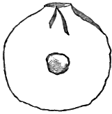 |
 |
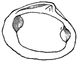 |
We have seen that the same formation, as exhibited in different places, differs in its thickness, composition and degree of solidification. If we could trace the strata through all the intermediate space, we might be certain of their being the same formation, notwithstanding the change in lithological characters. But this can seldom be done, even for a few miles in extent. Sections of the strata are obtained only occasionally, where rivers have cut through them, or where, over limited areas, the soil has been removed from the outcropping edges. It is also frequently the case that the strata are so much disturbed that their position will furnish no aid in determining their age. When folded axes occur (as here represented), the older strata are often the uppermost. There is an instance in the Alps in which strata of vast thickness have been inverted during the process of upheaval, and now rest on a bed of rock formed from the debris which they had supplied.
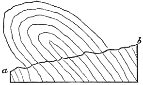
And yet it is important to determine what formations are of the same age, notwithstanding their displacements, difference in lithological characters, and separation by great distances and by mountains or oceans. This determination can be made only by a comparison of the imbedded fossils. It is found that every formation, and every important member of a formation, contains an assemblage of fossils peculiar to itself. When very widely separated, the species of fossils may not be identical, but so very similar that they are regarded as equivalent species. The identification of formations consists in the identification of fossils. It is for this purpose mainly that fossils are regarded as of so great importance.
6. If each formation is characterized by the presence of new species, it follows that the work of creation was a progressive one, continued through long periods of time. The latest creation of which we have any geological evidence is that of man. And if the leading design of the existence of this earth was as a theatre for the development of moral character, it is to be presumed that the work of creation ceased when a species possessing moral capacities had been introduced.
It follows also, from what has been said, that there has been a constant disappearance, a death, of species. It would seem that each species has a life assigned to it, which is to be completed and surrendered. Though its continuance is many times longer than the life of any individual of the species, yet it is the course of nature that species should disappear.
There may be something in the constitution of each species by which its continuance is limited, making an old age and death necessary, as it is in individuals. But there are other causes by which the duration of species may often be terminated. The subsidence of New Holland would cause the destruction of a large number of species. The preservation of the human species was at one time effected only by a special and miraculous interference. Slowly operating causes are now at work, by which many species, such as the elephant, wolf and tiger, will at length become extinct. Their existence in a natural state cannot long be continued in a civilized [63] country. The forest, their natural abode, disappears, and some are intentionally destroyed, because they render life and property unsafe. Under the operation of these causes, the Irish elk (cervus giganteus) has become extinct, probably within the human era. The Dodo, a gallinaceous bird, found living when maritime communication between Europe and the East Indies was first established, is now extinct. The Apteryx, a bird belonging to New Zealand, has probably become extinct since the commencement of the present century.
SECTION VII.—THE TIME NECESSARY FOR THE FORMATION OF THE STRATIFIED ROCKS.
There are no means of which the geologist can avail himself to determine the antiquity of the earth, or the amount of time since the sedimentary deposits commenced. But a nigh degree of antiquity may yet be shown.
The materials for all the stratified rocks have been obtained by the destruction of previously solidified igneous rocks. This destruction may have been accomplished in part by the operation of volcanic forces, but much of it is the result of slow disintegration, and of the eroding power of running water; and we can scarcely conceive of a period sufficiently protracted for such results.
This conclusion of the high antiquity of the earth is confirmed by observing that the stratified rocks consist of layers often not thicker than sheets of paper, and probably not averaging the tenth of an inch; and yet each layer is separate from the rest, in consequence of some change in the conditions under which it was deposited. Each layer was probably produced by the deposition of all the sediment furnished at one time, and hence only as many layers would be formed in a year as the number of freshets in the rivers which furnished the materials. If we consider the fossiliferous and metamorphic rocks to be each forty thousand feet in thickness,—which [64] is not too large an estimate,—we must reckon the years by hundreds of thousands to make the time sufficiently extended for the result.
All the formations of any considerable extent now above the surface of the sea existed before the creation of man, for none of them contain any evidence of the existence of human beings; and if they had existed while these strata were forming, sufficient evidence would have been left of the fact, either in the form of fossilized human bones, or of works of human art. Hence, whatever be the estimate which we form of the antiquity of the earth, from the slowness of denudation, or from the thickness of the strata, we must now add to that estimate the period elapsed since the creation of the human species.
We have seen that at different periods of the earth’s history different species of animals inhabited it. We are unable to fix with accuracy the ordinary duration of species. But the species which are now extinct probably had an existence as long-continued as will be enjoyed by species now living. Many recent species are known to have existed at least nearly six thousand years, without, in most cases, any indications of their soon becoming extinct. Whatever period be assigned as the ordinary duration of species, that period has been several times repeated; for the earth has been several times re-peopled, and every time by species which had not before existed.
Moreover, the amount of organic matter in the strata must have required long periods of time for its accumulation. The vegetable deposits, now converted into coal, are generally several feet thick, and often over a hundred feet, and are known to extend over several thousand square miles, both in this country and in Europe. Many of the sedimentary rocks consist almost entirely of animal remains. The mountain limestone, for instance, is eight hundred feet or more in thickness, and in some places consists of the exuviæ of encrinites and testacea.
In other cases the length of time required is shown, not from the amount of organic remains, but from the evidence that they were [65] deposited very slowly. The polishing stone called tripoli is found in beds of ten or twelve feet in thickness, and is composed entirely of the siliceous shells of animalcules, so minute that, according to the estimate of Ehrenberg, the number in a cubic inch is forty-one billions. Several other rocks, such as semi-opal and flint, are sometimes found to have a similar constitution. The time necessary for the accumulation of beds several feet thick by the shells of animalcules so minute must have been very great.
Each of these facts carries us back to a period immeasurably anterior to the creation of man, as the epoch when the sedimentary deposits commenced. There are no facts in geology which point to a different conclusion. It is of the utmost importance to the geological student to familiarize himself with this principle. It will assist him in comprehending the greatness of geological changes, and in applying other principles in explanation of geological phenomena.
This principle, so obvious to any one who allows himself to reason from the facts which geology presents, has sometimes been regarded as at variance with the Mosaic account of the creation. And if this account really assigns an antiquity to the earth of not more than six thousand years, the difficulty exists.
The statements made by Moses are found, upon examination, to be of the most general character. They assert, in the first place, simply that “In the beginning God created the heaven and the earth.” The time which elapsed after this first act, and previously to the acts of creation subsequently recorded, is not limited by the sacred narrative. It may have been during this indefinite lapse of time that God gave existence and enjoyment to a large number of animal species on the surface of the earth, and at the same time effected most of those physical changes in the crust of it which have rendered it a fit abode for intellectual and moral beings.
But if the word day, in the first chapter of Genesis, be considered to mean a prolonged period (and philologists regard such an interpretation as admissible), then that chapter is a record of the most important events in the history of the earth up to and including [66] the introduction of man. And the account, thus understood, coincides with the results of geological examinations.
Instead, then, of discrepancy between the works and the word of God, we have this remarkable fact, that a history of the earth, written long before the science of geology was known, is not contradicted, but confirmed, by the progress of science thus far.
OF THE CHANGES TO WHICH THE CRUST OF THE EARTH
HAS BEEN SUBJECTED.
SECTION I.—CHANGES WHICH HAVE TAKEN PLACE AT GREAT DEPTHS BELOW THE SURFACE.
The lowest change of winch we can gain any information is the formation of granite. It will be shown hereafter that it has been in a melted state, and that it has taken its present form on cooling. But whether any considerable portions of the granitic masses, or of the melted masses now below the surface, have resulted from the fusion of stratified rocks, we have not the means of determining. It is, however, not improbable, that in the changes of level to which the crust of the earth has been subjected, the stratified rocks may have gone down so far as to become melted. At the same time, the melted rock which is thrown to the surface by volcanoes is subjected to the various destroying agencies by which it becomes sedimentary matter, to be deposited as mechanical strata. Thus, as the igneous rocks from below are brought up to furnish materials for mechanical strata, there must be an equal amount of depression of the mechanical strata towards the seats of igneous action. And if this change takes place more rapidly than the thickness of crust increases, then portions of the sedimentary rocks must be undergoing fusion.
Next above the granite an immense thickness of rock occurs, which exhibits, from its stratification and from the water-worn fragments which it contains, distinct evidence of its mechanical origin. And yet it is very different from the later mechanical formations. [68] It is more highly crystalline; it has, to a great extent, assumed a cleavage distinct from the planes of stratification, and chemical affinity has been so far active as to produce new combinations, and give to them their peculiar crystalline form, as in the case of garnets, iron pyrites, &c. These strata also differ from those above them in containing no organic remains. It is not certain that organic life existed on the earth at the time when these rocks were deposited. Either it did not, or the evidence of it in the strata of that period has been obliterated. The changes have at least been sufficient to justify their being characterized as metamorphic rocks.
SECTION II.—CHANGES IN THE MASS OF THE STRATIFIED ROCKS.
1. The stratified rocks were deposited as mud or sand, and were at first in a yielding state. Most of these deposits have become solidified rock, such as limestone, clay slate and sandstone. The chalk of England is, however, but imperfectly consolidated, the great sandstone formation of New Holland is a friable mass easily disintegrated, and occasionally beds of clay in a plastic state are found as far down as the coal. Among the later rocks the solidification is less general, though there is some degree of hardening in all except the most superficial layers. The fissile structure results from the solidification of the particles composing each layer separately.
2. Since the solidification of the strata, or perhaps in connection with it, there has been something of movement among the particles, resulting in mineral veins, conchoidal structure, &c. One of the most general changes of this kind is that by which a mass becomes separable into thin sheets, independent of the stratification, and not parallel with it. This structure is represented by Fig. 48, in which the heavier lines are those of stratification, and the lighter of cleavage.
3. The strata have been everywhere more or less broken, and [69] the fractures, nearly vertical, extend to groat depths. When a fracture reaches the surface, it often becomes a channel for water. It is thus widened by the erosion, the deepest parts become filled with debris, and it becomes a gorge, ravine or valley.
If the fracture does not come to the surface, it becomes a cavern. In limestone, caverns which are formed in this way are very frequent, and extend for many miles. There is generally a stream of water running through them, but not of sufficient volume to have produced the erosion which has been effected.
When the sides of the fracture are but little separated, some mineral often separates itself from the adjacent rock, and filling up the space, reunites the broken parts. It is then called a vein of segregation (Fig. 49, a b). But the fracture is more frequently filled with some volcanic rock injected from below. It is then a dike (c d), and may have a width of many rods, though it often diminishes in width till it is a mere thread. A dike of which the injected material is a metallic ore is a mineral vein.
4. The uplifting force by which the fracture is produced has frequently raised the rock on one side higher than it has on the other. This is called a fault. (Fig. 50. The unequal movements by which the fault is produced seem in some instances to have been repeated several times, and the grinding of the broken [70] edges upon each other has polished and striated the sides of the fracture.
5. Sedimentary rocks are often found with the planes of their strata more or less inclined. It is evident that they were not thus formed. The depositions of sediment from water will always be horizontal, or, at most, only slightly inclined. But there is often evidence in the rock itself that its strata were once horizontal. It is frequently observed that vertical strata contain pebbles with their longer axes in the plane of the strata. (Fig. 51. When these pebbles were deposited, the longer axes would take, on an obvious mechanical principle, a horizontal position. Their present vertical position must have resulted from a change in the position of the strata in which they are enclosed. The same thing is shown by the position of a petrified forest in the south of England, known as the Portland dirt-bed. [71] Some parts of it are inclined at an angle of forty-five degrees. The position of the vegetable remains (Fig. 52) shows that when they were growing the surface was horizontal.
The line b d (Fig. 53), on inclined strata which makes with the horizon the greatest angle, is called the direction of the dip. The angle thus formed (a b d) is the angle of inclination. When inclined strata come to the surface, the exposed edge, b c, is the outcrop, and the line of outcrop on a horizontal surface is called the strike of the strata.
When the inclined position is produced by an uplift of the strata, along a given line, so that they dip in opposite directions, this line is called an anticlinal axis, as at Fig. 54. If, however, the strata are fractured along this line, as at b, the fracture becomes a valley of elevation.
If depression take place along a given line, as at c, the strata will dip towards this line, and it will be a synclinal axis. The depression will be a valley of subsidence. A synclinal axis would also be produced by an elevation of the strata, as at d and e, on each side of it, and the valley thus produced is one of elevation.
When successive sets of strata, as f and d, Fig. 53, are not parallel, they are said to be unconformable.
6. When the strata are subjected to displacement, they do not always take a merely inclined position, but are often contorted (Fig. 55), or folded together (Fig. 56). These folded axes frequently succeed each other for many miles. (See Figs. 7 and 82.) In the case represented by Fig. 56, if the highest portion has been removed, so that the line a b represents the actual surface, [73] we shall have apparently a succession of deposits, of which those at b would be the newest, and the oldest would be found at a, when in fact the strata at the extremities are parts of the same layer.
It is probable that disturbances like those now mentioned have been taking place continually, in different places, from the earliest times. There have been no periods of universal disturbance, and none of universal repose. On the contrary, the periods of disturbance in one part of the world have been periods of repose in another. For example, the coal measures of Europe were much broken and disturbed before the deposition of the new red sandstone, and the close of the coal period was at one time supposed to have been a period of general convulsion. It is now ascertained that the principal coal-fields in this country were not much disturbed at that period, and have not been since.
SECTION III.—CHANGES OF ELEVATION AND SUBSIDENCE.
The continents, if we except the more rugged and broken portions, rise from the sea with an almost imperceptible ascent; and even the mountains have a much gentler slope than we are apt to suppose, so that a section of the earth parallel to the equator would be almost a perfect circle. The slope of a mountain, from its base to its highest point, rarely forms with the horizon an angle of as much as twelve degrees. In the following figure (57), A represents the peak of Chimborazo, B of Teneriffe, C of Ætna, and D of Mount Loa, the principal volcano of the Sandwich Islands. The highest mountains would be represented on a twelve-inch globe by an altitude of less than the one-hundredth of an inch above the level of the sea. But the rising and sinking of these masses, though so small compared with the dimensions of the earth, are yet geological changes on the largest scale.
1. The Elevation of Mountains.—Mountains have formerly [74] been covered with the waters of the ocean. This is evident, in the case of some mountains, from the existence of stratified rocks reaching to the summits. The stratification could have been produced only by deposition from water. It is, moreover, evident from the existence of marine fossils, distributed through these strata, so abundantly, that they cannot be accounted for on any other hypothesis than that the animals lived and died where the remains of them are now found. These strata must therefore have formed the bed of the sea while the fossils were accumulating.
There is no direct evidence that the granitic mountain peaks were ever submerged. But there is reason for believing that the sedimentary strata which now occupy the lower slopes were, at the time of their deposition, continuous,—the igneous rock having subsequently broken through them,—so that the waters of the ocean once rested on the whole area which the mountain now occupies!
If the ocean could ever have been above its present level sufficiently to have covered all the sedimentary rocks, we might assume that the height of mountains has not been changed. But the level of the ocean cannot be subject to much variation. The total amount of water on the globe is always the same. If the continents and mountains were all submerged at once, and the [75] waters were expanded by the highest temperature consistent with the liquid form, there would not be a change of level of more than two hundred and fifty feet. We may assume, then, that the ocean level has always been essentially the same that it now is. We must therefore conclude that the sedimentary rocks, and the mountains of which they form a part, have been elevated to their present position from the bed of the sea.
Different mountain ranges have been elevated at different periods. The silurian and carboniferous formations were deposited before the Alleghany Mountains, which they contributed to form, were elevated; while the new red sandstone and the cretaceous and tertiary formations were deposited subsequently to the upheaval. They are accordingly found at the base of the range, nearly horizontal, and have risen above the level of the ocean only as the continent generally has risen. The Pyrenees were elevated after the deposition of the cretaceous rocks, and have carried them up so that they appear at a high angle, while the tertiary rocks at the base are horizontal, as in the United States. The Andes have carried up the tertiary rocks with them, and their elevation must therefore belong to a recent period. It appears that they are even yet rising.
It has recently been shown that the Alps have been subjected to upheaval at several distinct periods. At the close of the silurian period they formed a cluster of islands. At the commencement of the tertiary period they became a mountain range, and at the close of that period they were thrown up some two thousand feet higher, to their present position. Nearly the same things will probably be found true of other mountain ranges, when their structure has been minutely studied.
The elevation of contiguous parallel ridges will necessarily leave intervening valleys of elevation. As mountain ranges generally consist of several such ridges, valleys of this description are numerous, and they are often of great extent.
It is obvious that there are mountains in the sea of as great height above the lowest valleys as the mountains of continents are [76] above the level of the sea. If a new continent should hereafter be formed by the elevation of a large area of the bed of the sea, the existing mountains, now appearing in the form of islands, would partake of the general movement, and the new continent would have the same general diversities of surface as existing continents. The mountains would have existed long before the continent. It is therefore to be supposed that the mountains of the present continents were elevated before the continents, and that they stood for long periods as islands, exposed to the action of waves, tides, and marine currents.
2. The Elevation of Continents.—Continents have been elevated by so slow a movement that it has not generally been perceived, even when they have been peopled by nations advanced in civilization. And yet satisfactory evidence is always left of former sea-levels.
Almost every seaboard furnishes examples of beaches, evidently once washed by the sea, but now elevated more or less above high water.
At Lubec, near the northern extremity of the coast of Maine, barnacles[A] are found attached to the rocks eighteen feet above high water. The pilots at that place, and for a hundred miles north and south of it, speak of the ship-channels as diminishing in depth, though it is certain that they are not filling up. Such facts are to be explained only by supposing that the coast is rising.
[A] The barnacle is a marine animal, permanently fixed to the rocks, and live but a short time without being surrounded by sea-water.
Lakes are numerous throughout the northern portions of North America, which are receiving annually large quantities of sediment, and must ultimately become alluvial plains. Those of moderate depth, as Lake Erie, cannot require periods very protracted to fill them. Their continuance in such abundance indicates that the elevation of the continent to its present height is comparatively recent. This conclusion is confirmed by evidence of another kind. Throughout this region of lakes, beds of clay containing the remains of existing species of marine animals, are found at all elevations from the sea-coast, to the height of about four hundred feet, but not higher. These clay beds are very recent, and were [77] deposited when the surface was four hundred or five hundred feet lower than it now is; and this amount of elevation has left the existing lakes scattered over the surface.[A]
[A] “It is remarkable that on the shores of the great lakes there are certain plants the proper station of which is the immediate neighborhood of the ocean, as if they had constituted part of the early flora of those regions when the lakes were filled with salt water, and have survived the change that has taken place in the physical conditions of their soil.”—Torrey’s Flora of the State of New York.
The following (Fig. 58) exhibits Europe as it was during the Silurian epoch, and Fig. 59 as it was at the commencement of the tertiary epoch. The land, as it then existed, is represented by the white surface, the present waters by the dark shading, and the land which has been reclaimed from the ocean by elevation since those periods by the lighter shading.
The whole southern part of South America, embracing an area equal to that of Europe, has been elevated within a very recent period; and some parts of it, if not all of it, are still rising. The shells found on the plains from Brazil to Terra del Fuego, and on the Pacific coast, at a height of from one hundred to thirteen hundred feet, are identical with those now inhabiting the adjacent seas. And “besides the organic remains, there are, in very many parts, marks of erosion, caves, ancient beaches, sand-dunes, and successive terraces of gravel,” all which must have resulted from the action of the waves at a period not remote. At Lima, articles of human skill peculiar to the original inhabitants of Peru were found imbedded in a mass of sea-shells eighty-three feet above the present sea level. The elevation on the Pacific coast has been in part by sudden uplifts of a few feet at a time; but it is found, from time [79] to time, that there has been a change of level, amounting to a foot or more in a year, when there have been none of these sudden movements.
A considerable portion of Europe, reaching from North Cape in Norway to near the southern part of Sweden, more than a thousand miles, and from the Atlantic to St. Petersburg, more than six hundred miles, has been rising at the rate of about three feet in a century, for at least two centuries, and probably much longer. This change is proved by the occurrence, at considerable elevations above the sea, of shells now found in the Baltic; by rocks once sunken, now raised above the surface of the sea, and by ancient seaports having become inland towns. To determine the truth by actual measurement, the Royal Academy of Stockholm, about thirty-five years since, caused marks to be cut in the rocks along the coast, to indicate the ordinary level of the water. This is easily ascertained, as the Baltic is nearly a tideless sea. The present level of the sea, compared with that indicated by the marks before mentioned, leaves no doubt that the country is rising.
3. The Subsidence of Land.—Elevations can be shown to have taken place by fossils, and by other evidences of former sea levels which are left on the surface; but depressions leave but few indications of change of level. It is yet doubtful whether the depression is equal to the elevation; that is, whether the amount of land remains nearly constant, or whether there has been an augmentation of the dry land within the tertiary and recent periods. We are certain that the augmentation, if any, has not been equal to the elevation, for subsidences to a great amount are known to have taken place.
There are occasional instances of submerged forests seen at low tide, at some distance from the shore. There are several near the coast of England and Scotland, and near the coast of Massachusetts. They are but a few feet below low water, and do not indicate a subsidence of more than about twenty feet.
Numerous instances are on record of the sinking down of wharfs and buildings near the sea during earthquakes. Almost [80] every violent earthquake is accompanied by a change of level. The changes of this kind which have been noticed are in seaport towns, because greater facilities are there afforded for detecting them, and because loss of property awakens attention to them; but there is every reason to suppose that these changes of level extend to great distances both into the country and into the sea.
An immense area in the Indian and Pacific Oceans, probably ten millions of square miles, is undergoing change of level. The lines A B and D G (Fig. 60) represent nearly the axes of depression; while an intermediate and two exterior parallel lines would represent axes of elevation. The evidence of these changes is found principally in the peculiarities of the wall of coral rock encircling the islands.
The following figures represent, in sections, modifications of form of the same island. The coral wall built up around the island by the polyps, from the depth of fifty,[81] or at most of a hundred feet, is shown at c c (Fig. 61). If the island is elevated, this wall becomes a fringing reef (Fig. 62), b′ becoming the level of the sea, and the animal begins a new wall at the same depth as before. But if the island is gradually sinking, the wall is kept built up to the surface, and becomes a barrier reef (Fig. 63). A channel is thus left between the island and the reef, which, though gradually filling up with broken coral or other sediment, is generally deep enough for a ship-channel. If the island continue to subside till it disappears, and the coral wall is still kept at the surface, it then becomes an atoll, a circular coral island (Fig. 64), often of many leagues in diameter, beaten by the surf on the outer edge, but enclosing a quiet lake, which communicates only by occasional channels with the ocean.
The islands contiguous to the lines A B and C D (Fig. 60) are uniformly atolls, or are surrounded by barrier reefs, and are therefore subsiding; while the islands at a distance from these lines are surrounded by fringing reefs, which indicate that they are rising.
A well-authenticated instance of gradual subsidence is that of Greenland. The entire western coast, from its southern extremity to Disco Island, a distance of six hundred miles, has for the last two centuries been slowly subsiding. The dwelling-houses and places of worship built by the early European settlers are now in part or entirely submerged. The natives are said to be aware of the subsidence, and never build their huts near the sea.
4. We have thus seen that both elevation and depression may take place. There is reason to believe that these changes of level have, in some cases, been several times repeated. In one of the eastern ranges of the Andes, opposite to Chili, there is a mass of marine strata of five thousand feet in thickness. About the middle of the series there occurs a silicified forest. In one place a clump of coniferous trees was found of more than fifty in number, and a foot or more in diameter. The base of the strata must have been twenty-five hundred feet below the surface of the sea, in order to admit of the deposition of the first half of it. It was [83] then elevated, so that a forest grew upon its surface. It was then depressed at least twenty-five hundred feet, more, to admit of the deposition of the subsequent strata, and the whole is now uplifted to form a mountain range of eight thousand feet in height.
The temple of Jupiter Serapis, near Naples, in Italy, was built near the sea, about eighteen hundred years ago. It was gradually submerged, and finally lost by the deposition of sediment nearly to the top of the columns. It was afterwards elevated, so as to be entirely above the level of the sea. The remains of the temple (Fig. 65) were afterwards discovered by the columns projecting a little above the ground. The sediment was removed to the depth of forty-six feet, when the workmen came to the base of the columns, [84] and to a pavement seventy feet in diameter. In 1807 an artist was employed to take drawings of the ruin. The pavement was then above the level of the sea. Sixteen years afterwards the same artist found the pavement covered with water, and the depth has continued to increase since that time. It is considered that for the last forty years the depression has been three-fourths of an inch a year.
Instances enough have now been given to show how extensively the system admits of change. They are sufficient to justify us in searching for indications of great revolutions in past times, even where no such indications have as yet been discovered. They will serve as a key to many otherwise inexplicable phenomena, In order to the interpretation of such phenomena readily, we must cease to look upon these as exceptional cases, and regard them not only as facts, but as facts of frequent occurrence.
From the examples which have now been given, as well as from speculations upon the cause of these changes, it seems highly probable that all the surface of the solid portion of the earth, whether land or the bed of the sea, is undergoing changes of level. It may be so gradual that in the life of an individual it would be imperceptible, even where the best means of detecting it exist. These means are generally the works of man, and they are themselves so liable to change, that it would be scarcely possible to detect variations of level, which amount to but a few inches in a century.
If we admit that the relations of land and water have always been variable, it is impossible to arrive at any certain conclusion as to the amount, position or form, of the dry land at any former period. We may determine, with some degree of certainty, what portions of the present continents were submerged at particular epochs. Thus, we may infer that most of this country was submerged during the silurian period, from the great extent of the Silurian rocks; and, from the limited extent of the chalk formation in this country, we know that during the cretaceous period most of the continent was above the surface of the sea. But we have [85] absolutely no data for determining what portions of the bed of the sea were at any time dry land.
It is supposable that the land has been principally confined to the equatorial regions at one period, and to the polar at another. At still a different period the land may have existed as islands scattered through a general ocean. These relations may, therefore, be assumed to have existed, if there are geological phenomena which best accord with such relations.
SECTION IV.—CHANGES ON THE SURFACE OF THE EARTH.
1. The principal changes of this class consist in the wearing down and removing immense quantities of the surface rock. The form in which the igneous rocks, of which the entire crust of the earth was originally composed, now appear, furnishes no assistance in judging of the amount of denudation which they have suffered. We can judge only from the amount of rock for which they have furnished the materials, and these are the whole sedimentary series which exist both as dry land and as the bed of the sea.
2. The sedimentary rocks have also been subject to great denudation; and we often have, in what is left, some indications of how much has been removed. One of these indications consists in the now level surface of those portions of country in which large faults exist. By the excavations for coal, in England, faults have been discovered of five or six hundred feet. At the time that they were formed, the surface must have presented precipitous escarpments (as represented by the dotted lines in Fig. 50) of a height equal to the dislocation; but the whole is now reduced to a general level (z z), denuding causes having removed the elevated portions.
The extent of valleys will often give some idea of the amount of denudation to which a region has been subjected. In the north-west of Scotland there is a succession of hills of about three thousand feet in elevation, consisting, for the upper two thousand feet,[86] of horizontal strata of old red sandstone. (Fig. 66. We cannot conceive that these mountain masses were deposited in their present isolated form. The whole intervening spaces must have been filled with strata continuous with those by which the elevations are formed.[A]
[A] “I entertain little doubt that when this loftier portion of Scotland, including the entire Highlands, first presented its broad back over the waves, the upper surface consisted exclusively, from one extremity to the other, of a continuous tract of old red sandstone; though, ere the land finally emerged, the ocean currents of ages had swept it away, all except in the lower and last raised borders, and in detached localities where it still remains, as in the pyramidal hills of Western Rosshire, to show the amazing depth to which it had once overlaid the inferior rocks.”—Miller, Old Red Sandstone, p. 22.
A somewhat similar instance occurs in the Connecticut river sandstone, in the central part of Massachusetts. The following figure (Fig. 67) represents two mountains of 1 the sandstone, between which the Connecticut river flows. The dotted lines indicate a depth of one thousand feet of the rock which has been swept away. [87] It is also thought that a bed of equal depth has been removed from this section southward, through the State of Connecticut, to the sea-coast.
3. Valleys, and even many of the larger valleys, are produced by the wearing down of the surface. The lower portion of the Connecticut valley is one of denudation, though in its upper part it is a valley of elevation, resulting from the upheaval of the Green and White Mountains. The water-courses from the mountains are transverse to the direction of the ranges, and generally consist of valleys of denudation. These valleys were no doubt originally fractures, produced while the mountains were rising. The fractures have been subsequently widened by denudation into valleys.
4. The rocky surface, beyond the fortieth parallels of latitude, and in the vicinity of glacier-producing mountains, is generally covered with grooves and striæ (Fig. 68), varying from several inches in depth to the finest perceptible lines. Rocks that are of a soft consistence, or which have been long exposed to atmospheric agents, seldom exhibit these marks, though there are probably few places, outside of the parallels before mentioned, where the rocky surface, if it has been protected from atmospheric decay, does not contain such grooving.
5. Another change at the surface consists in the formation of a soil; that is, of a superficial layer, of no great thickness, of earthy matter, a large proportion of which is always in a minutely divided state. In some instances it is common sediment, unsolidified; in [88] others, it consists of the surface rock in a state of disintegration; but a large part of the soil within the region where the grooved surfaces are found consists of materials transported from a distance.
Soils are distinguished according to their predominant minerals, as siliceous, aluminous and calcareous. If siliceous matter is in excess, it will be a light, warm soil, and allow the water to pass through it too freely. If the clay predominates, the soil is cold, stiff, and too retentive of moisture. A proper admixture of these three ingredients constitutes the best soils. There are some other mineral ingredients essential to the productiveness of soils, but they are always in small proportion. In addition to the inorganic part which is common to the upper soil, and the subsoil, there is required, in order to render the upper layer productive, a large admixture of decaying animal and vegetable matter.
SECTION V.—CHANGES OF CLIMATE.
Our means of determining the climate of any former period consists in a comparison of the fossils of such period with the existing forms of life in warm and cold climates.
The earliest abundant vegetation consisted principally of ferns, rushes and mosses, and a larger growth was attained than is attained by any of the allied forms of the present time. We may infer that the circumstances under which these lower forms of vegetable life are now produced in the largest proportion, compared with other forms, and under which they grow to the largest size, are the circumstances approaching most nearly those under which the early vegetation was produced. These circumstances are found to be a position elevated but little above the level of the sea, a humid atmosphere, and the highest terrestrial temperature. Such facts favor the conclusion that during the coal period an ultra-tropical climate prevailed, and that the land existed in the form of low islands, thickly set in a general ocean.
The peculiar characters of some of the animal fossils, from the earliest fossiliferous to the tertiary series, indicate that a warmer climate prevailed during their formation than now exists. The remains of marine animals, such as the cephalopoda, are found in great numbers and in high latitudes, in a fossil state; but similar species, as the nautilus, now abound only between the tropics. The same is true of the crinoidea. Coralline limestone is also found in great abundance and in high northern latitudes; but the stone-producing coral now exists only in very warm seas. The remains of saurian reptiles are numerous in the oölite and Wealden; but all the larger recent species of the lizard tribe, such as the crocodile, are confined to the warmer regions of the earth.
A former warm climate in Siberia is indicated by the occurrence there of the remains of elephants. These animals were so abundant that their tusks are now collected as an article of commerce. The abundance and high state of preservation of these remains seem to preclude the explanation that they were conveyed there, from the present tropical regions, by any great geological convulsion. The species must therefore have inhabited the country, though the elephant is now found only between the tropics. The Siberian elephant was a different species from any now existing, and, unlike the recent species, had a covering of coarse hair. There is, however, no reason to conclude that it could endure a continued low temperature; and its sustenance would have been impossible, from the very stinted vegetation which that region now affords. We must therefore suppose that Siberia enjoyed, at the period when it supported these animals in such abundance, a tropical climate.
Most of the facts which go to prove a change of climate have been observed in the northern hemisphere; but the explorations in South America and New Holland furnish ground for believing that the geological phenomena of the two hemispheres are essentially alike, and that the indications of climate are the same for the same periods.
Such is, in general, the evidence in reference to climate; and it [90] leads to the conclusion that a highly tropical climate prevailed in the temperate, and for some distance, at least, into the polar zones, in the early geological periods; while there is no reason for supposing that the tropical regions experienced a temperature too high for physical life to endure it. The climate of the earth was characterized then by a higher temperature than now, and by greater uniformity. This was the climate, with perhaps a gradual reduction of temperature, till the later portions of the tertiary period.
Before the close of the tertiary period, a change occurred, and probably a rapid one, to a more rigorous climate than now exists. The destruction of the elephant in Siberia was evidently sudden, and was followed by extreme cold; for the animals are in some cases entirely preserved in ice, and in so perfect a state that, when the ice which surrounds them becomes melted, the flesh is devoured by carnivorous animals. There are occasionally found, in the drift of the boulder period, shells similar to those of the Arctic regions, and in a condition to show that they have not been transported. The clay beds of the northern portion of the United States and of Canada were deposited during the last depression of that portion of the continent, and they contain the remains of marine animals identical in several instances with species now living, but confined to more northern regions. It must therefore be admitted that the interval between the middle tertiary and the modern era was one of great cold. It is generally referred to as the Glacial period.
Very considerable local changes of climate have also occurred within the historical period. Thus the mean temperature of the Alps has been so reduced that the ancient passes have in modern times become choked up with snow, and other passes have been sought,—a result, perhaps, of additional upheaval. It would seem that Siberia is now receiving a milder climate. The ice in which elephants have for centuries been imbedded has been slowly melting for at least thirty years.
SECTION VI.—ADVANTAGES RESULTING FROM GEOLOGICAL CHANGES.
1. The division of the general surface into land and water, as well as the diversified form of the land, the existence of mountains and low lands, and the consequent modifications of climate, the waterfalls, and the river-systems, constituting the drainage of continents, are all results of the process of upheaval.
2. A large part of the mineral substances employed for architectural and economical purposes are oceanic deposits, such as the marbles, slates, sandstones and mineral salt, and would have been inaccessible if they had not been elevated from the position in which they were formed. And the elevation of them above the bed of the sea would have exposed only the superficial layer, if they had not been either irregularly uplifted, as at e c (Fig. 69), or unequally worn down, as at b.
The granitic rocks, as they were formed below the aqueous rocks, must have remained unknown and useless, if they had not been brought to the surface, as at c, by the most convulsive efforts of nature of which we have any knowledge. Thus, natural mechanical forces have effected for man what the mechanical forces under his control would be entirely insufficient to accomplish.
3. It is by changes of this kind that we become acquainted with [92] the geological structure of the crust of the earth. Mining operations have never extended to a greater depth than three thousand feet, while the inclined position of the strata exposes for examination, along their outcropping edges, e a c, the whole series, even to the primary rocks. The upheaval of the granitic rocks, and the removal by denudation of the overlying deposits, shows us the crystalline character which the earthy materials take, when subjected to pressure and cooled from fusion with extreme slowness. Thus we have, exposed to observation, the process of nature in the formation and modification of rocks for several miles in depth. Of the central portions, however, including by far the largest part of the mass of the earth, we have no knowledge whatever.
4. Springs, and the other means of obtaining water for domestic purposes, depend in part upon the inclined position of strata, and the broken and uneven condition of the surface, and in part upon the alternation of permeable and impermeable strata. If all the strata were porous, like the sandstones, the water which falls upon the surface would gradually settle through them to the level of the sea; or, if they were all impermeable, like the clays, the water would pass over the surface, and be collected in lakes or the ocean. As it is, the porous structure of the soil and of some rocks acts as a reservoir, from which the water is gradually discharged, and the intervention of impermeable strata prevents its taking a perpendicular direction downwards. Thus, if the stratum e b (Fig. 69) consists of porous rock, and the one below is impermeable, the water which is absorbed at e will appear at b as a spring. Or, if the line a d is a fracture, the water received at c may reappear as a spring at a. If the strata were perforated by boring at e till the porous stratum a is reached, the water will rise to the surface, constituting an Artesian well. An ordinary well consists of an excavation continued till a stratum is reached which is permanently saturated with water.
5. Most of the metallic ores which occur in the stratified rocks, with the exception of iron, are found in fractures or as dikes.[93] Without these disturbances of the strata, the ores would have remained either sparingly diffused throughout the adjacent strata, or as a part of the melted mass at the volcanic centres. The ores and metals which are found in the primary rocks are accessible only by the bringing up of these rocks to the surface.
The fracturing, displacement, and elevation of the strata, attended, as is often the case, with the destruction of property and of the life both of man and the inferior animals, might, at first view, be thought an unnecessary, if not a wanton infringement upon arrangements already established. But the results which we have noticed, though by no means a full enumeration of the advantages resulting from geological changes, are sufficient to show that even the more violent disturbances to which the crust of the earth has been subjected constitute an important part of that series of adjustments which has rendered it a suitable abode for human beings. These changes are therefore neither useless nor accidental, but are essential parts of a wise and beneficent system.
OF THE CAUSES OF GEOLOGICAL PHENOMENA.
An exhibition of the composition and structure of the earth, together with an account, as far as there is reliable evidence, of the modifications which they have undergone, has been the object of the preceding chapters. They are mainly a collection and classification of observed facts. No reference has been made to causes or modes of operation, except in a few cases where it was necessary in order that a statement or description, might be intelligible.
If the facts have been given with sufficient clearness and detail to convey a correct general idea of the crust of the earth, we are prepared to inquire what are the agencies employed, and how they have operated in producing it. It is the province of the geologist to question every known power in nature, and to ascertain what geological effects each one is now producing; and, observing what effects are produced by given causes, he is to judge of the causes which have produced like effects in past geological periods.
Some of these causes are in their nature limited, and effects can be referred to them only within those limits. Thus, the congelation of water expands it by a certain proportion of its volume, and beyond that it can have no effect. But the expansive power of steam varies with the temperature; and hence the effects referred to it may be equally varied. Thus, we are not to expect exact uniformity of results in all past times, but the results will vary only as the circumstances vary upon which the operation of these causes depends.
Geological causes, in most instances, operate with extreme slowness; and therefore it will require a series of observations, continued for a long time, to ascertain what are the capabilities of these causes. But a single instance of their effects proves their capabilities thus far. Hence, one instance of the deposition of a stratum of salt in a salt lake; of the filling of a fracture with fluid lava; of a volcanic eruption, like that of Iceland in 1783; of the subsidence of a volcanic mountain, as that of Papandayang in Java; or of the rising of a large area of land, as in Sweden, as fully proves that natural causes exist capable of producing these effects, as if the effects were produced daily. As these effects increase in number, and careful observations are made and authentic accounts preserved, the means of correctly explaining geological phenomena will increase. The causes thus far known are Atmospheric Causes, Chemical Action, Organic Agency, and Aqueous, Aqueo-glacial and Igneous Action.
SECTION I.—ATMOSPHERIC CAUSES.
The oxygen of the atmosphere is capable of uniting with some of the constituents of rocks, by which their cohesion is weakened or destroyed. This is the cause of the rapid disintegration of some varieties of granite. The protoxide of iron which they contain is converted, by contact with the atmosphere, into the peroxide. Its volume is thus increased, and portions of the rock are separated from the mass. When granite or limestone contains sulphuret of iron, the oxygen of the atmosphere, in connection with moisture, combines with the sulphur, forming sulphuric acid, by which limestone and the felspar of granite are rapidly decomposed. Hence, a rock which contains an oxide or sulphuret of iron should not be used for architectural purposes.
Carbonic acid is another constituent of the atmosphere which operates as a decomposing agent. The water that falls from the atmosphere is charged with it, and thus becomes capable of dissolving [96] calcareous rocks. Carbonic acid is thus indirectly the means of the rapid destruction of rocks of this class. It is also believed that carbonic acid enters into direct combination with some of the constituents of rocks, and particularly felspar; for it is found that in those countries where carbonic acid issues in great quantities from the earth, the rocks, especially those which contain felspar, disintegrate rapidly. Masses of many tons’ weight, which appear to be solid granite, after being broken are found to be in such a state of decay that fragments may be reduced to sand between the fingers.
The moisture of the atmosphere has some effect as a decomposing agent. Rocks which are exposed to frequent alternations of moisture and dryness soon crumble into fragments. Rain, falling upon the surface of rock, produces, mechanically, a destroying effect, which is not to be overlooked.
Variations of temperature, especially those alternations above and below the freezing point, have greater influence than any other cause in the destruction of rocks. When the water with which a rock is saturated congeals, the resulting expansion tends to enlarge the interstices, and thus to separate the particles of the rock. When the ice melts, the particles fail to resume the closeness of arrangement with which they were before packed. By frequent repetition of this action, the superficial portion loses its cohesion, and disintegrates. It is also found that in the region of perpetual snow the surface of the mountain masses is covered with rock in a disintegrated or fragmentary state, in greater abundance than below the snow line; but no explanation of this fact has yet been found.
In mountainous regions, electrical discharges and violent storms have some destroying effect. Winds have considerable power in changing the place of earthy matter in a disintegrated state. In deserts, the sands are carried in great quantities to great distances.
The causes now enumerated, when considered separately, and as acting for only limited periods of time, seem hardly worthy of [97] notice; but when considered as operating conjointly, and for indefinite periods of time, they must have produced important changes on the surface of the earth.
From these causes, the surface and ornaments of castles and other ancient edifices, and of boulders, and all insulated rocks, are found to be decayed, and often to a considerable depth. It is from these causes that a soil is produced on every surface of rock which is not so exposed to the action of currents that the debris is removed as fast as it is formed. Hence it is, also, that a slope of detritus is formed at the base of every declivity, so that the ledge appears only at the highest points.
It is from a combination of these atmospheric causes that a large part of the sediment is furnished which brooks and rivers carry away. And when cohesion is not entirely overcome, it is so far weakened that other causes are much more effectual than they would otherwise be, in effecting the disintegration of rocks.
All those changes in which the action is molecular,—that is, between the molecules as such, and not between the masses,—including the effects of the imponderable substances, we regard as resulting from chemical agency.
Under the control of these molecular forces the crystalline rocks have taken their form; and if the crust of the earth could have remained in a fixed condition, in which these forces would have been in equilibrium, no further chemical action could have taken place. But, instead of being in a fixed condition, the present system is one of perpetual change. Various disturbances of this equilibrium of forces,—such, for instance, as the diurnal and annual changes of temperature at the surface, and the still greater secular changes of temperature at great depths,—will bring the chemical forces into operation. The mechanical disintegration of the crystalline rocks, and the deposition of them in strata independently of [98] the chemical affinity of their particles, will give occasion for chemical changes,—that is, for a rearrangement of the particles in accordance with their affinities,—whenever any movement of the particles among themselves can take place. These movements take place, to a very great extent, under the influence of electrical currents, and of change of temperature, even while the masses retain their solid form.
Chemical affinity has exhibited itself on the largest scale in the formation of the various mineral species of which the crust of the earth is composed; but we may also refer to the same cause the formation of divisional planes in rocks, the concretionary arrangement, and mineral veins.
1. Divisional Planes.—It has before been stated, that the older rocks, in many cases, cleave freely in planes not parallel with the stratification. (See Fig. 48.) In some instances, in beds of lava, a similar cleavage exists, sufficiently perfect to allow of its use as a roofing material. In these cases, there must have been a rearrangement of the particles, so that their axes of greatest attraction would lie in parallel planes; the same arrangement which exists in mica and other crystalline substances, which have one and but one free cleavage.
A similar arrangement has sometimes taken place under such circumstances as to submit the process to more careful scrutiny. In the gold mines of Chili, the powder from which the gold has been washed is “thrown into a common heap. A great deal of chemical action then commences; salts of various kinds effloresce on the surface, and the mass becomes hard, and divides into fragments which possess an even and well-defined slaty structure.” When a portion of clay, worked into a paste with a very weak acid, is submitted to a weak voltaic action for several months, and then dried, it is found to have acquired a distinct though imperfect cleavage structure.
It appears, then, that both electrical currents and ordinary chemical action are capable of arranging the particles of an earthy mass into separable layers. We may then regard this change in the [99] older rocks as an imperfect crystallization, and probably induced by electro-chemical agency.
It is also found that all rocks are divided into huge blocks by seams not parallel with the cleavage, and too regular to be considered as fractures. These seams bear an analogy to the secondary faces of crystals, which are never parallel to the cleavage.
2. Concretionary Formations.—There exist in many rocks concretions which differ from the mass of the rocks. In most of the tertiary clays there are small concretionary nodules, which contain more calcareous matter than the mass of clay around them. In the coal formation, the nodular iron ore consists of concretionary masses. In the chalk formation, nodules of flint abound, and generally in layers. In many of these cases, particularly in the clays and coal, the nodules have an organic nucleus, and, although concretionary, they retain the marks of stratification of the adjacent rocks. Hence they could not have been deposited in the form of nodules. There must therefore have been in the rock, though in the solid state, such motion among the molecules that particles of a particular mineral have separated from the mass and rearranged themselves in concretionary layers, yet so gradually as not to disturb the lines of original stratification.
There are other instances, similar to the last in all respects, except that the segregated portion does not take the concretionary form. When gypsum is distributed in small proportion through a formation, there seems very little reason to doubt but that it is, by a molecular action, segregated from the strata in lenticular masses, as at a (Fig. 70). Many of the limestone strata contain irregular aggregations of quartz. It is presumed that the siliceous and calcareous matter was deposited together as sediment, and that the aggregation has resulted from a movement among the particles similar to that by which the concretionary structure is produced.
The columnar structure of basalt seems to have resulted from [100] a peculiar molecular action, at first resembling a concretionary arrangement, while the mass was cooling from a state of fusion. In experimenting to ascertain the cause of this structure, Mr. Watt fused in a furnace seven hundred pounds of basalt. When cooled, he found that “numerous spheroids had been formed, and that when two of them came in contact, they did not penetrate each other, but were mutually compressed and separated by a well-defined plane, invested with a rusty coating. When several met, they formed prisms.” (Fig. 71.
3. Mineral Veins.—The phenomena of veins are such that they cannot all be referred to the same cause. In some, the vein-stuff has been protruded as a dike, differing from ordinary dikes only in the accidental circumstance that it contains a metal or a metallic ore.
Mineral veins are not, however, generally filled by injection from below. It is found that those veins only are productive which have an east and west direction. But injected dikes run in all directions. The ore often varies in richness at different depths in the vein, or passes into ore of some other metal. The ore also varies in kind and quality, according to the character of the rock through which the vein passes. These phenomena are best explained by supposing that the sediment of which the strata were formed contained the mineral substances of these veins in small proportion. After they were solidified, and fractures had been formed, the mineral substance was transferred by molecular action to the fissures, and deposited.
It was shown by the early experiments of Davy, that voltaic currents are capable of taking up mineral substances from their solutions, and removing them from one cup to another. It has been ascertained that in most mineral veins a proper apparatus will detect the existence of electric currents. It may be regarded as certain, that the unequal heating of different parts of the surface at the same time, by the sun, causes a vast current of feeble [101] intensity to circulate around the earth once in twenty-four hours. The unequal distribution of heat below the surface may also produce currents subject to other laws. We should expect that these currents would take up the mineral substances diffused through rocks, and deposit them by themselves. It seems probable, therefore, that the molecular action, from which the segregation of metallic veins has resulted, was that of voltaic currents.
The effects of all organic causes in producing geological changes are inconsiderable, compared with those of inorganic causes. With the exception of the coral formation, the most important of these effects are those produced by human agency. We find examples of this agency in the distribution of animals and plants beyond the regions where they are indigenous; in the increased numbers of certain species, and in the diminution, if not extinction, of others; in the modifications of climate, dependent on the destruction of the forests and the cultivation of the soil; in controlling the course of rivers; in arresting by embankments the encroachments of the sea; in breaking up and changing the place of great quantities of rock by mining and engineering operations; and in the increased quantity of sediment furnished to streams by cultivating the surface, and thus preventing the protecting influence which the matted roots of trees and the smaller vegetables would otherwise have. Such effects, though attributable mainly to man, are produced in some degree by all other animals.
Besides these general effects, it is the existence of organic forms that has conferred on all the sedimentary rocks their fossiliferous character. The records of the climate of each geological period, of the physical geography, of the vegetable productions, and of the animal forms by which the earth was peopled, consist in the remains of the living beings of these several periods, imbedded in the contemporaneous rock formations. But in the sediment [102] deposited since the human era there must have been furnished both the remains of human beings and works of art, such as implements of labor and war, pottery, coins, fragments of ships, &c.
Moreover, the quantity of material which has been furnished by organic causes is by no means small. The coal-beds are the product of vegetable growth exclusively. We not unfrequently find strata of great extent consisting almost entirely of the shells of molluscous animals, of the stems of encrinites, or of the shields of microscopic animalcules.
But the most abundant rock which can be regarded as the product of animal organization is the coral formation. It consists of immense walls of coral limestone, separating either an atoll or the land of an island or continent from the open sea. The base of this wall has a width varying from a hundred feet to a mile or more, and the outer edge of it is at such a distance from the shore as to give a depth not much exceeding a hundred feet. Over this area of the bed of the sea, which forms the base of the wall, the coral polyp commenced its work. Attaching itself in immense numbers over this area, it deposits calcareous matter from its under surface, and thus, by degrees, elevates itself towards the surface of the water, till it reaches a level a little above low-water mark. The height of the wall would not, with these conditions, exceed one hundred feet; but some hundreds of the islands surrounded by coral walls are gradually subsiding. The depositions of the polyps keep pace with the subsidence, so that this wall has reached an elevation from its base of a thousand feet, and in one instance of two thousand feet. (See Figs. 61, 62, 63, 64.)
Most of the islands of the torrid zone are thus surrounded with coral reefs, except a few where the cold polar currents reduce the temperature too low to admit of their growth. In one instance, along the north-east coast of New Holland, there is a coral reef, some twenty-five miles from the land, which has a continuous extension, excepting occasional inlets of no great depth, of a thousand miles. The reef along the island of New Caledonia is four hundred miles long. A large number of other reefs have a nearly [103] equal extension. There is thus an area of several thousands of square miles covered to a great depth with this coralline limestone. Some limestone formations of great extent among the older rocks were the work of similar animals. These lower forms of organization have, therefore, always been important geological agents, both in collecting the carbonate of lime from its solution in the waters of the ocean, and in depositing it as solid rock.
Water is, next to heat, the most important geological agent. All the stratified rocks are aqueous deposits, and their total amount is in some respects a measure of the influence which this agent has exerted. The materials have been obtained from the destruction of preëxisting rocks, transported by water, and deposited in layers.
When the first strata were formed, the sediment must have been obtained entirely from igneous rocks, because only those rocks existed; but now it is obtained from every kind of rock which is exposed to abrading or decomposing agencies. Hence, many of the later formations contain fragments, and sometimes within the fragments well-characterized fossils, of earlier formations.
The sediment which is ultimately to become stratified rock is deposited on the beds of the ocean, and other great reservoirs of water. The formation of most of the aqueous rocks, therefore, as well as of the igneous rocks, is deep below the surface; and neither of these operations, on the large scale, is directly exposed to our observation. We may, however, learn by observation, how the sediment is furnished to the waters and transported by them, and we can form some correct ideas of the manner in which it will be laid down on the bed of the ocean, and solidified.
I. The Furnishing of Sediment.
1. Almost all the minerals which occur in the geological formations are, to some slight extent, soluble in water. Hence, rain [104] water, by passing through a stratum of earth or rock and reäppearing as a spring, loses the insipidity which it had as pure water, and becomes palatable. It is then found to hold in solution some small proportion of earthy substances, upon which this change of taste depends. Although the proportion of dissolved matter is very small, yet the surface of earth upon which this distilled water is shed is one-fourth of the surface of the globe, and solution below all that surface is constantly taking place. No inconsiderable amount must thus have been furnished, from the existing rocks of each period, towards the formation of the strata of a later period.
There are some substances which are soluble in water, in large quantities. Rock-salt is an example. It is not found in any very large proportion in rocks generally, but a very large aggregate amount has been taken up by the waters which have filtered through the strata. The ocean gathers into itself, by degrees, all the soluble substances which are thus taken up. It receives supplies of water charged with these substances from springs, rivers and lakes. It returns as much water as it receives; but it is always in the form of vapor, and is therefore pure water. Hence the saline properties of the ocean, and of those inland seas which have no outlets. There is thus gathered the materials for the rock-salt deposits.
But many substances which are not considered soluble in water become so by some modification of the water. Water of a high temperature is capable of dissolving silex. In Iceland and other volcanic regions, the hot springs are charged with silex, which is deposited as the water cools. Thus, siliceous formations accumulate around springs of this kind. The various agates may have been deposited from such solutions.
In the decomposition of mica, felspar and volcanic rocks, a considerable amount of potassa is set free. Potassa or soda renders the water in which it is dissolved capable of dissolving silex in large quantity. In these ways water removes, with some degree of rapidity, one of the most insoluble minerals which rocks contain.
In volcanic countries, and in coal districts, carbonic acid is abundant, both in spring-water and in the gaseous form. Water charged with this gas becomes capable of dissolving limestone. Where the water is exposed to the air, the gas gradually escapes, and the calcareous matter is deposited. Many accumulations of this kind are now taking place. Some have already extended several miles in length, and they are often of great thickness, in one instance, in Italy, two hundred feet (Fig. 72). It is also probable that many calcareous springs issue below the surface of lakes and seas, and thus, both fresh-water and marine deposits would now be forming. These formations are distinctly stratified, and are white and crystalline, and become solid at the time of deposition.
These dissolved materials are less observed than others, because they do not render the water turbid; but there is reason to believe that several of the aqueous formations, particularly the limestones, have been built up chiefly from them.
2. The abrading action of rivers furnishes considerable detrital matter. The general form of the river courses is determined by other causes than the agency of the river itself, yet a river which has a rapid current is continually deepening its channel. We have [106] proof of this by observing, when the water is low, that irregularity of surface which running water always produces, by wearing away the softer parts of the rock, and leaving the harder in relief. Hence, a river will have its rapids either where the hardest strata occur, and which therefore wear down least rapidly, or where the rock has been hardened by the intrusion or near proximity of dikes.
The abrading power of rivers occasionally becomes greatly increased by waterfalls. The force which the water acquires in its descent is such as to excavate a deep cavity at the foot of the fall, reaching back under the ledge from which the water descends. The ledge is therefore constantly being undermined. The cataract of Niagara is peculiar, in having the rock at its base of a soft and friable texture, so that it is rapidly worn away, while the upper rock is a compact siliceous limestone. If the order of superposition had been the reverse, the falls would have been converted into a series of rapids. It is now preserved as a single fall, and as such it has probably cut the gorge, about two hundred feet deep and seven miles in length, through which its waters now reach Lake Ontario. A few years since, a large mass, perhaps half an acre in area, fell from the centre of the horse-shoe fall. Another mass of equal size has recently fallen from the western extremity of the ledge. Thus the fall is gradually receding.
But the foreign substances, such as drift-wood, ice, sand and gravel, with which the waters of a river are occasionally charged, contribute more than everything else to its abrading power. At such times its volume is generally greatest, and its current the most rapid. Its bed is then sometimes perceptibly deepened and widened in a few hours.
Much the greater part, however, of the earthy matter which rivers convey in such quantity to the ocean, is furnished by other means than the eroding action of the river itself. It is the loose material, the soil and alluvium, to which the solid rocks have been reduced by the imperceptible but incessantly operating atmospheric agencies, from which most of the sediment of rivers is [107] obtained. After a rain, every tributary rivulet is turbid with suspended earthy matter, and it is from these sources that the larger streams receive the most of their sediment.
Some observations have been made for the purpose of ascertaining the quantity of sediment which rivers annually carry into the sea. The Kennebec furnishes materials which, if spread evenly on an area of one mile square, and consolidated into rock of the specific gravity of granite, would have a thickness of six inches. The Merrimac furnishes about two-thirds as much, the Ganges about two hundred and fifty times as much, and the Mississippi two thousand times as much.
Thus, the tendency is, to reduce the highest parts of the land, and to fill up the depressions of the sea; and though we have not data enough to form any reliable estimate of the total annual discharge of sediment into the ocean by rivers, yet they are sufficient to show that the effects of this kind are on a large scale, and to relieve us from any impression that existing agencies are inadequate to the production of the stratified rocks.
3. The action of waves is another means by which detrital matter is furnished. Wherever the shore consists of loose materials, and is favorably situated to be acted upon by the waves, there is annually a sensible encroachment of the sea. Such encroachments are rapidly making in many places; and thus a large amount of sediment is delivered to the waters of the ocean.
The waves also encroach upon the coast when it consists of rocks, even of the most indestructible kinds. They continually beat upon it, undermine the cliffs, and precipitate them into the sea. The tides increase the power of the waves, by varying the place of their action, so as to present the same surface of rock alternately to the action of water and of the air, frost and sun. During storms, the waves have sufficient force to break off fragments of rock from the escarpment, sometimes in masses weighing twenty tons or more, and remove them many rods inland.
A bold, rocky coast always exhibits evidence of a great amount of erosion. The steep escarpments and the high rugged shafts of [108] rock (Fig. 73) against which the waves now beat are the remnants of masses of rock which once extended further into the sea, but have been worn away by the waves. It is by such agency that the deep inlets and harbors of the coast of New England and Nova Scotia have been excavated.
This more violent action of the waves is only occasional; but when of less power, they are incessantly rolling the loosened fragments of rock upon each other, and thus wearing them down to particles small enough to be carried away by the water.
4. The action of waves is confined to the coast, and never extends to great depths. But marine currents act principally on the bed of the sea. The temperature of the mass of the ocean is much higher in the equatorial than in the polar regions. At the surface, the difference amounts to sixty degrees. The waters of the torrid zone are thus expanded, and flow over the colder waters of the north and south; while these colder waters of the polar seas flow back, in an under current, towards the equator.
For the same reason,—a difference of temperature,—there will be, in the higher regions of the atmosphere, a current of warm and [109] moist air flowing from the equator north and south, while the cold and dry air conies in from the polar regions towards the equator. In this way the equatorial waters are carried, in a state of vapor, towards the poles, where they are condensed, and go to increase the currents of water moving towards the equator.
Such are the general causes of the oceanic movements in a north and south direction; but these currents at once become deflected westward, by the diurnal revolution of the earth, as the trade winds do. Hence there results a Pacific equatorial current, which has a motion of about thirty miles a day, and an Atlantic equatorial current, moving from sixty to seventy miles a day. The principal marine currents are shown in Fig. 74.
The currents moving towards the poles are superficial, and therefore do not produce any marked geological effects. But the polar currents, and those which are produced from them, are of great depth, and there is no reason to suppose that they do not move, from their commencement, along the bed of the ocean. There is also reason to suppose that they exist at great depths, where the opposing superficial currents entirely conceal them.
Wherever these currents come to the surface, their motion is undoubtedly greater than it is at the bottom, where it is retarded by the friction which the moving waters encounter, and by the irregularities of the bed of the ocean. It should, however, be remembered, that they move with the weight of the whole superior body of water; and therefore, though the motion be very slow, it will still possess great power.
Any irregularities in the bed of the ocean beneath such a current must be subject to very rapid abrasion. We shall sea hereafter, that earthquake vibrations often shiver the rocks at the solid surface; and if any of these ridges at the bottom of the ocean were thus acted upon, the loosened portions would be swept away by the current and deposited at lower levels, or where the current subsides. If, in any instance during an earthquake convulsion, a fault should be produced across one of these marine currents, like the great fault of over five hundred feet in England, the abutment thus thrown up would soon be worn down; and if it consisted of unconsolidated matter, it would be swept away almost bodily.
The effect of such currents will be greatest where they are deflected by a continent or island. Thus, a marine current sets from near New Holland in a direct line to the north of the island of Madagascar, where it is arrested by the African coast, and deflected into the narrow Mozambique channel, and there acquires a velocity of four or five miles an hour. It is impossible that any kind of rock should receive the constant force of such a body of water without being rapidly worn away; and, if there should be any difference of texture in this rocky barrier, the softer portions would yield the most rapidly, and thus valleys might be formed.
It is not improbable that the deep indentation on the western coast of Africa may have been due, in a great measure, to the coast current from the Cape of Good Hope; and that the Caribbean Sea and the Gulf of Mexico may have been excavated by the force of the Atlantic equatorial current being thrown into this angle.
We may regard these currents as oceanic rivers; and it is obvious that the volume of the terrestrial rivers would bear no comparison with that of these currents, and their effects would be equally small in the comparison. The Gulf Stream, and the Mozambique and other similar currents, must be wearing down the valleys through which they flow, to such an extent as to furnish an immense amount of detrital matter for the formation of new rocks.
It is principally to the agency of these deep marine currents that we are to refer those extensive denudations, so abundant on the present continents, such as the wearing out of the intermediate masses of rock between the hills already referred to (Fig. 66), the denudation of the Connecticut river sandstone, and, perhaps, the excavations which have formed Lake Erie and Lake Ontario.
II. The Transportation of Sediment.
The detrital matter obtained in these several ways is swept [112] away by running water. The specific gravity of rocks does not, in general, exceed two and a half. Hence, to keep them suspended in water, will require a force of only three-fifths of what would be necessary to suspend them in the atmosphere. In the case of river currents, the velocity and irregularity of motion are generally sufficient to keep all the finer sediment equally distributed.
There will, however, be a division of the sediment according to the strength of the current. Hence, the bed of a mountain stream, if there is any loose material, always consists of pebbles. As it approaches the alluvial region, the bed is sandy; and when the current becomes very sluggish, it consists of a fine mud.
Rivers never deposit all their sediment, some of them none of it, along their course. Large rivers continue partially distinct from the ocean water to a considerable distance beyond their mouths. The waters of the Amazon have been recognized at a distance of three hundred miles. This depends in part upon the volume and velocity of the river; more, however, upon the fact that river water is lighter than sea water. This extension of a river will, in most cases, be sufficient to deliver a part of its sediment into a marine current. When such a current sweeps very near the mouth of a river, as it does to that of the Niger, the Amazon, or the Mississippi, it is probable that most of its sediment is carried away by it.
The transporting power of a marine current is greater than that of a river, in consequence of the greater specific gravity of its water; but it has scarcely any of that irregular motion of rapid rivers, upon which their transporting power in a great degree depends. The force of the current alone, when it reaches the bottom, is, however, sufficient to remove every form of loose earthy matter. Thus it may be presumed that the Gulf Stream sweeps all the sediment from its bed until it reaches the latitude of Cape Hatteras, where the cold waters from the north begin to underlie it, and it takes the character of a surface stream.
But the transporting power of marine currents depends mostly upon the depth of water. It is found, by experiment, that ordinary river sediment will sink in water about one foot in an hour. A [113] current, therefore, of a thousand feet in depth, which moves a mile in an hour, would carry its sediment a thousand miles. It is obvious, then, that there is no part of the bed of the sea which may not be receiving sediment.
III. The Deposition of Sediment.
From what has been said of the weight of sediment, it follows that it will be deposited whenever the water in which it is suspended is at rest. Hence, when a river increases in breadth so as to form a lake, the waters at the outlet are seldom turbid. The earthy matters with which the principal and tributary streams were charged all settle to the bottom, and go to lessen the capacity of the reservoir. Thus lakes are continually diminishing in depth and area. In many instances, they are already filled with sediment, and are thus converted into alluvial plains, through which the river flows in a narrow channel.
It is frequently the case that a river, as it approaches the sea, has so slow a motion that its sediment is deposited on the bed of the stream. Thus the bed will be raised, and the banks will also be raised, by the deposition of sediment upon them at periods of overflow. The river will then be raised above the adjacent country. The river Po, for the last part of its course, is from ten to twenty feet above the adjacent lands. The same is true of the Mississippi, and many other rivers. The streets of New Orleans are several feet below the surface of the river. In an uninhabited country, such a river would soon seek a new and lower channel; but in a populous country, it becomes a matter of interest and safety to confine the river in its old channel, by artificial embankments.
But the principal part of the sediment of rivers is conveyed to the sea. It here mingles with the debris which the waves have furnished, and a part of it is deposited to form deltas. The remaining part is taken up by marine currents, mingled with the debris which they have furnished, and is spread out on the bed of the ocean.
Of the extent of these deposits we can form no estimate. Those of rivers and lakes are comparatively unimportant, as they are in [114] the older formations. Some of the delta deposits are already of great extent. That of the Ganges contains an area of twenty-six thousand square miles, that of the Niger twenty-five thousand, and that of the Nile twelve thousand. The delta of the Rhone has increased its area by three hundred square miles in the last thousand years. The Po has encroached upon the Adriatic two thousand square miles in the last two thousand years, and the Mississippi has enlarged its delta by one hundred square miles in the last hundred years. In the deep valleys of the ocean accumulations may be taking place on as large a scale as they ever have been in former times.
IV. Character of the Formations thus produced.
Sedimentary matter thus deposited would take the form of strata. Thus, a delta deposit may receive at one time from a river a layer of coarse gravel and pebbles, and in the course of a few hours the current may be so reduced that it will convey to the same place only fine sand and silt. Or, if a depositing current receive its sediment only at intervals, the heaviest particles would be thrown down first, and the more finely levigated particles would continue to fall, till the water became transparent. Another supply would furnish another similar stratum, and so on. The same arrangement might result from the sediment being furnished by different rivers. Thus, if sediment were furnished to the Gulf Stream by the Merrimac river, and the streams emptying into the Bay of Fundy, the freshets would occur earlier in the season in the Merrimac, and it would furnish a supply of sediment from a region of primary rocks. A later supply would come from the red sandstone region of Nova Scotia, and the stratification would be indicated by the different kinds of rock produced. Thus stratification will result from difference in the color, composition, or size of the particles of which rocks consist. A great variety of causes, both general and local, may therefore give to a deposit this character. Hence, as stratified rocks are produced by the sediment now laid down from water, we may conclude that the older stratified rocks are the sediment deposited in like manner, in former times.
The occurrence of layers of different composition, as one way in which the stratification is indicated, is produced by local and frequently recurring causes. There are, however, other alternations of much greater extent; those, for example, nearly twenty in number, distinguished by striking differences in lithological character, into which the New York system of rocks is divided. These alternations have resulted from more general causes. The physical geography of a wide region must have been so different, at the different periods during which these several formations were deposited, as to change, at each period, the kind of sediment furnished to the forming currents, and modify the types of animal life.
We have seen that the same causes that determined the stratified arrangement will determine the alternations of strata of coarse and fine materials.
It is obvious that the stratification of the marine deposits will be nearly horizontal. If the surface were very irregular upon which the deposition commenced, the irregularity would constantly diminish; for the movement of the water over this surface, however slow, would tend to remove the accumulations from the highest points, and leave them at the lowest (Fig. 75). Delta and lake deposits will, however, dip somewhat, though never at a high angle, towards the deep water. In certain situations, where a river and a tidal wave, coming in conflict, cause, in succession, eddies and currents in opposite directions, we should expect to find the stratification very irregular (Fig. 76); sometimes false stratifications (a b), sometimes the strata cut off abruptly, and at other times contorted or dipping in opposite directions within short distances.
Wherever sediment is deposited, it will entomb whatever of the remains of animal or vegetable life may be mingled with it. They will be at once protected against the influence of all the ordinary decomposing agencies, and will continue for ages to retain their peculiar markings, and even their colors. They will thus constitute, in all future time, a record of the present condition of the organic [116] world. The lacustrine deposits can contain only fresh-water species of animals, marine deposits only marine animals, while deltas may contain the remains of marine life mingled with those which have been washed down by rivers. The remains of birds, insects, and terrestrial animals, may occasionally occur, in every kind of deposit. Sediment deposited in deep water will never contain fossils in abundance, the deep parts of the ocean being almost wholly destitute of animal or vegetable life. It is only in water of a few fathoms that the greater number of species and of individuals occur. In all these particulars the deposits now forming sustain a close resemblance to the older formations.
There are certain formations, as that of the coal, which required conditions for their formation different from those of ordinary sedimentary deposits. Coal consists of mineralized vegetable matter. Its vegetable origin is proved by the uniform occurrence of vegetable fossils almost exclusively in the coal measures. When reduced to thin slices and examined under a high magnifying power, a structure very similar to the ligneous tissue of existing coniferæ is sometimes found to exist. There are probably vegetable [117] deposits now taking place not altogether unlike those which produced the coal measures.
We know that many rivers—the Mississippi, for example—now carry into the sea great quantities of ligneous matter. Before the country was inhabited by man, the quantity was undoubtedly much greater than it now is. It floats for a time; but the ligneous tissue itself is heavier than water, and as soon as the air is excluded from the pores, and they are filled with water, it will sink. The woody and earthy matters are swept into the sea together; but, as they sink under different circumstances, they will be deposited separately. Thus wood may continue to accumulate in particular places in the sea for long periods, with but little intermixture of earthy substances.
It is, however, to be expected that, in the progress of geological changes, the places which at one time receive deposits of wood will at another receive detrital matter, and thus the wood will become deeply buried beneath sedimentary strata.
Wood thus situated will become converted into coal. Trees which had been covered to considerable depth with earth have been found near the Mississippi river changed to lignite, a substance resembling charcoal. In this case, the wood had been exposed to no greater heat than is common to the crust of the earth at the depth where it was found; and yet it had undergone this change since the country has been known to Europeans, as it retained the marks of the axe when it was discovered. It has also been found by experiment that vegetable matter, by long submersion in water, passes into the state of lignite. This is the first step in the conversion of wood into mineral coal.
When lignite is exposed to moderate heat and great pressure, it loses the characters of lignite, and becomes mineral coal. This is shown by facts observed in Germany, Ireland and Iceland, where beds of lignite have been overspread by basalt. The upper portions of the lignite are changed to mineral coal. The lower portions, which the heat did not reach, retain the characters of lignite.
Beds of vegetable matter, with a great thickness of rock deposited above them, would therefore be subject to all the conditions necessary to convert them into coal, namely, pressure from the superincumbent mass, and the heat which the strata uniformly assume at great depths.
It is not improbable, therefore, that coal-beds are now forming, and that they have been formed at every geological period since an abundant terrestrial vegetation commenced. Accordingly, there occurs in Virginia an extensive coal-field in the oölite formation. Coal-fields also occur in England, of less extent, in the same formation. In France, and other parts of Europe, there are extensive beds of lignite in the tertiary formation.
We have therefore no difficulty in accounting, in a general way, for the formations of the carboniferous period. The vegetables were probably less woody than those of the present time of equal size, and were therefore more easily prostrated and committed to the waters. They grew rapidly in moist ground, and perhaps in shoal-water, and required an atmosphere charged with moisture and of a high temperature. Thus much is inferred from the conditions most favorable for the growth of recent species analogous to the coal-plants. These recent species are tropical plants, and grow in moist insular situations, conditions which would have existed at the carboniferous period, if the present coal-fields were then an archipelago dotted with low islands.
Such being regarded as the origin of the coal-beds, the alternations of the earthy and carbonaceous strata may be referred, provisionally, to those great changes in physical geography upon which the other alternations of strata on a large scale depend. But the regularity with which the coal-seams and sandstone succeed each other presents some difficulties which, in the present state of knowledge, we cannot satisfactorily account for.
Beds of salt occur, interstratified with other rocks, in nearly all countries. Still, it is not a sedimentary deposit, and its formation must depend upon peculiar circumstances. In New York, saline, together with earthy matter, constitutes the Onondaga limestone,[119] one of the formations of the New York system. In Kentucky, the strata of rock-salt are in the coal formation; in England, they are in the new red sandstone; in Spain, they are in the greensand, and in Poland they are in tertiary strata. The conditions of its formation have therefore existed in connection with the deposition of every fossiliferous rock.
It has been shown that the ocean is the principal reservoir of the saline matters which are taken up whenever water percolates through rocks. It must happen not unfrequently, in the course of submarine elevations, that a basin of sea-water will be cut off from its communication with the sea; and from this basin the evaporation might be more rapid than the supply of water. The great salt-lake of Utah is undoubtedly a basin of this kind. The Mediterranean Sea is another such basin, not yet wholly separated from the ocean. The evaporation exceeds the supply of water from the rivers, and a powerful stream is therefore continually thrown in from the ocean, through the Strait of Gibraltar. The waters of the Mediterranean are already more highly charged with salt than ordinary sea-water. This sea may ultimately become a saturated solution, and begin to deposit salt. But whether it does, or not, it indicates the way in which salt-beds may be formed.
V. Solidification of Aqueous Deposits.
Sediment is generally deposited as a soft mud, but in nearly all the older formations it has become solidified. When rocks are deposited from a chemical solution, they take at once the solid form. Such is the case with rock-salt and with limestone, when the material has been held in solution. Solidification takes place in nearly the same way when water which holds carbonate of lime or oxide of iron in solution filters through beds of sand or gravel. The substance held in solution is deposited in the interstices till they become filled, and the whole is changed to solid rock.
Some rocks are composed of such materials that they set, like hydraulic cement, when they are deposited. Other rocks become solid simply by drying. Thus a deposit now forming in Lake Superior becomes, by drying, nearly as hard as granite. Such a [120] deposit will therefore become solid whenever it shall be elevated above the water.
The pressure to which all but the upper layers are subjected is probably sufficient to reduce most rocks to the solid state. Dry and pulverized clay is reduced by artificial pressure, for a moment, almost to stone. The pressure upon the deep-seated rocks is constant, and greater than any artificial pressure can be.
In addition to these causes, all the older rocks have been subjected to a high temperature, some of them nearly to that of fusion. By this means the solidification of every kind of rock would be promoted, and probably some may have been reduced by it to the solid state, which would otherwise have remained as an incoherent mass.
SECTION V.—AQUEO-GLACIAL ACTION.
1. Glaciers.—A glacier is a mass of ice occupying the bed of a mountain valley, having a slow progressive motion, and reaching somewhat lower in the valley than the line of constant snow. (Fig. 77. The Glacier des Bois, which may be regarded as a specimen of the Alpine glaciers, covers an area of about seventeen square miles. In its lowest portion, when all its branches have become united into one stream, it has an average width of half a mile, and is five miles long. It is estimated that the glaciers of the Alps cover an area of fourteen hundred square miles. These have been the most carefully studied, though glaciers are found in the valleys of various other ranges of mountains.
In the higher valleys, the snow, which falls at all seasons of the year, accumulates in immense quantities, and the steep mountain sides contribute, by frequent avalanches, to this accumulation. The snow, when thus increased, does not become a compact, adhesive mass; but, changing into particles of solid ice, it resembles sand rather than snow. It is this névé which constitutes the upper part of every glacier, and which, in a modified form, constitutes the lower part.
The valleys descend rapidly towards the base of the mountains; and this snow-ice, having no cohesion between its particles, moves slowly down the slope of the valley, like a very imperfect liquid. After descending below the line of perpetual snow, the surface will melt during the day; and the water, sinking into the porous mass, becomes frozen, and converts the whole into more or less compact ice, yet never into a rigid mass. Influenced by its own weight, and by the pressure of the snow-ice behind, it still continues its motion, and conforms itself to the shape and curves of the valley through which it passes. The average movement per annum may be stated at about five hundred feet.
The temperature of the rocky bed of the valley will be a little, and but a little, higher than thirty-two degrees. There will therefore be but little melting at the bed of this river of ice. As it receives continual accessions from the atmosphere, it will therefore increase in volume till it descends to the level of perpetual snow. Below this line the waste exceeds the addition; and as it approaches the lower and cultivated portions of the valley, it rapidly diminishes, till it finally loses the solid form, and becomes a rivulet. The terminus of the glacier is determined principally by the general climate of the country. Any considerable variation of climate will cause it to recede, or descend lower down the valley. The terminus varies, however, somewhat with the seasons, being lower in winter than in summer, though the motion is much less in the cold season than in the warm; and it descends many rods further some seasons than it does others.
The glacier consists principally of snow, more or less modified in structure; but it also contains whatever else may have been thrown upon its surface, or into the snows by which it is fed. Tributary glaciers extend up through all the gorges into which the irregular surface of the mountain-top is divided. On these rough peaks there are always fragments of rock, varying in size from fine sand to masses weighing many tons; some of them loosened when the mountain was upheaved, some by subsequent earthquake vibrations, and others still by tempests, lightnings, and changes of [122] temperature. When the snow has accumulated to a certain extent on the steep slopes, it falls in avalanches into the valleys, carrying with it loosened masses of rock, and often breaking off large fragments from the rocky escarpments against which it strikes. These avalanches are almost constantly descending, and hence a glacier always contains considerable earthy matter distributed through it.
The friction of the glacier, at its edges and along its bed, separates more or less of the rock over which it moves; and hence [123] there is always a layer of mud and pebbles under the glacier, and a line of loose fragments, called a lateral moraine, at the sides. When two glaciers unite, the two lateral moraines, thus brought together, come to the surface, forming a medial moraine, and show the line of junction sometimes for miles.
The friction of the glacier on the bed of rock, assisted by the layer of pebbles, will wear down the prominent portions, and everywhere polish the surface. Fragments of rocks may be frozen into the glacier at all depths. Those which lie near the lower surface of the glacier would, by slight melting of that surface, project downward so as to act as a graver’s tool on the rock over which it passes. Hence, when the extremity of the glacier has receded beyond its ordinary limit, the surface of rock exposed is found, upon examination, to be polished, striated, and occasionally grooved an inch or two deep.
Since the waste is almost wholly superficial, earthy matter, which was at first concealed in the mass of the glacier, is continually coming to view, as the surface melts and runs off. Thus, none of the freight of the glacier is left along its course, but all is carried to its terminus and discharged there. Hence, at the lower extremity of the glacier there is always an embankment of earth, pebbles, and boulders. If the glacier recedes a few yards at one season of the year, and leaves its earthy fragments scattered over this surface, they will be pushed forward into a ridge, as the glacier again advances. This ridge is called a terminal moraine, and consists wholly of substances which have been separated from the mountain mass, often at the highest beginnings of the glacier. At the terminus of all the Alpine glaciers, there is a series of these moraines (a a a, Fig. 77) marking the successive limits of the glacier in former times.
There is a ridge of boulders on the north side of the Swiss valley, near the base of the Jura Mountains, resembling a terminal moraine. These boulders consist of several groups, distinguished by peculiarities of structure and composition; and each group lies opposite to the particular Alpine valley which now furnishes the [124] same kind of fragments. It has been thought that, at a former period of more severe climate, the Swiss valley was filled in part with ice, and that the present glaciers extended across it to the Jura Mountains.
It is found that the polished and striated surfaces of the rocks in the Alpine valleys are precisely like the surface of the rock, which has not been exposed to atmospheric influences, in the north of Europe and America. It has been proposed to extend the glacier theory, and account for these phenomena by supposing that the north polar regions were, at the ice period, capped with a glacier-mass, extending as far south as the drift phenomena appear.
It is not to be doubted that the phenomena of polished surfaces and transported materials in the immediate vicinity of the Alps, and near other high mountains, are correctly referred to glacial action. This theory has therefore solved, in part, one of the most difficult problems in geology; but there is great difficulty in extending it so as to account for the drift phenomena in general. If the motion depends upon gravitation only, the origin must have a much greater elevation than the terminus, which would not be the case in the great glacier supposed to extend southward from the Arctic regions. Elevation of temperature, it has been thought, might account for the movement of the mass southward.
2. Icebergs.—In very high latitudes, the ice, which makes out from the land into the sea during the cold season, suffers but little waste at any time. This sheet of ice continues to increase in breadth and thickness, by congelation, from year to year. The spray and the snows of each succeeding year will also add to the mass. It thus accumulates to the height of several hundred yards. It will also reach down a good many feet below the surface of the sea, and will extend back on the land, or lie heaped up against a precipitous escarpment, and firmly frozen to it.
After a certain amount of extension over the sea, the accumulated weight of the ice and snow would tend to depress it, and break it loose from the shore. The waves would tend to the same [125] result, and would act at greater mechanical advantage, as its extension from the shore becomes greater. Hence, it would ultimately become separated from the shore, and float in the water.
At its commencement, the earth, pebbles and rocks, which may lie along the shore, and as far down into the sea as the congelation extends, are frozen into it. In many situations its mass would be increased by avalanches while it remained attached to the land, and these would supply also masses of earth and rocks, as they do to glaciers. When it becomes loosened from the shore, it will break off, and carry with it some of the earthy portions of the coast, or the less firmly fixed masses of rock from the escarpment against which it formed. Thus every iceberg becomes freighted, more or less, with earth and rocks. This has almost uniformly been found to be the case, when they have been landed upon by ships’ crews and examined.
We have seen that the general tendency of the waters of the ocean, and of the lower stratum of the atmosphere, is to a motion from the poles towards the equator. However irregular, therefore, the course of an iceberg may be, its general movement, influenced both by the prevailing winds and by ocean currents, will be towards the equator.
These floating ice-mountains (Fig. 78) are formed in great numbers, and of vast size. The relative specific gravity of ice and water are such that nine cubic feet of ice, below the surface of [126] water, will support one cubic foot above it. As icebergs are often one or two hundred feet high, their vertical depth must be a thousand feet at least; and their area is equal to a square mile, and sometimes it is much greater. In 1840, the United States Exploring Expedition, in the extreme southern ocean, coasted for eighty miles along a single iceberg. They are never absent from the polar seas; and at certain seasons they are so abundant along the usual course of vessels from New York to Liverpool, as greatly to obstruct and endanger navigation.
An iceberg may continue for some time to increase in size, while floating in the polar seas, but will at length reach a latitude where the waste will exceed the additions, in consequence of the temperature both of the air and of the water. It will, therefore, drop gradually the earthy matters which it contains, upon the bed of the ocean.
It is not improbable that icebergs may often reach down so far as to strike the highest points of the bed of the sea. The ice would be lifted, and glide over the elevation, without suffering any perceptible deviation from its general course. It would thus affect the surface of rocks exactly like a glacier. If, however, the iceberg becomes permanently stranded, and melts in one place, its earthy matters will be thrown down upon the elevation which first arrested it.
If the bed of the sea, between the fortieth and sixtieth degrees of latitude, could be exposed for examination, the rocky surface would be found to be polished and striated by the icebergs which have passed over it, and the whole surface would be strewed with boulders and drifted materials brought from Arctic and Antarctic lands. Sometimes it would be accumulated in heaps, and sometimes spread nearly over the surface.
We have seen that very recently, probably about the close of the tertiary period, the portion of Europe and America over which the northern drift is found, has been depressed several hundred feet. It may be presumed that at that time icebergs floated over it, polished the surface of the rocks, and distributed the boulders and other drift which is now found upon it.
I. Of the Temperature of the Mass of the Earth.—Heat has been the most efficient agent in determining and modifying the structure of the earth; and, in order that the explanations of the phenomena referable to this cause may be intelligible, some idea must be formed of the actual present condition of the mass of the earth with respect to heat.
At any point of the surface there are variations of temperature, depending on external causes. But these variations are found to extend only a little way below the surface,—never more than a hundred feet. At greater depths, it is found that the temperature invariably increases with the depth. Deep mines have always a temperature above the mean annual temperature at the surface. The water obtained by deep boring is always tepid when it comes to the surface. The thermal springs, so abundant in this country and in Europe, are so situated as to justify the impression that their waters come from great depths. To make these general observations of any value, we must determine the law by which the temperature increases. The result of all the observations yet made, in mines and upon wells and springs, is that, below the first hundred feet, the temperature increases by one degree of Fahrenheit’s scale for every forty-five feet.
Regarding this law of increment as applicable to all depths, at ten miles below the surface we should have a temperature above that produced by the combustion of wood; and at twenty-five miles, a temperature of three thousand degrees, by which nearly all mineral substances would be reduced to a state of fusion.
The general conclusion of a temperature sufficient to melt the mineral substances of which rocks are composed, at no considerable distance below the surface, is confirmed by the fact that portions of the interior of the earth—at least, at the volcanic centres—are in a melted state. The intimate connection between some volcanoes situated a hundred miles or more apart, so that they are alternately in a state of activity and rest, indicates that these centres are connected,—that [128] subterranean melted lava extends from one to the other, so that when one is active, the elastic force is relieved at the other. These deep-seated lakes of lava must therefore underlie large areas.
We are justified, then, in concluding that the mass of the earth, with the exception of a comparatively thin superficial layer, has a very high temperature.
By way of accounting for this temperature, it is now generally assumed that the earth was originally in a state of fusion; that it was a mass of liquid lava (if, indeed, it had not a temperature sufficient to reduce it to the aëriform state). Starting with this assumption, there must necessarily be a gradual reduction of temperature by radiation, and a time must arrive when the surface would be crusted over with solidified lava; and this crust would increase in thickness as the cooling advanced, the interior still retaining its heat and liquidity. The present condition of the crust of the earth, its form, that of an oblate spheroid, with the exact difference of the equatorial and polar diameters which is found to exist, as well as the phenomena of volcanic eruptions, will all admit of explanation on this hypothesis.
It has, however, been rejected by some; and, to account for the heat of the interior of the earth, it is suggested that, if the bases of the earths and alkalies, particularly potassium, sodium and calcium, exist in their metallic state beneath the surface, the rapid oxidation of them by the access of water would generate heat of sufficient intensity to melt the oxidized materials, and thus account for the phenomena attributable to heat.
Either of these hypotheses may be adopted; but it is not necessary to account at all for the existence of this temperature. The fact is susceptible of proof; and, though we may not be able to frame any hypothesis to account for its existence, we may yet employ the fact in the explanation of other phenomena.
II. The Action of Internal Heat in producing Volcanoes.
The phenomena of volcanoes and earthquakes are evidently produced by some force operating from below. The effect of heat [129] alone would be to reduce the rock to a liquid state. There is no reason to suppose that it is ever sufficient to reduce them to the aëriform state. The elastic force must therefore depend upon some other substance associated with the lava, and this substance is water.
This will be shown by an examination of lavas. At the time of their ejection, they are in a fluid or semi-fluid state; but it is not a complete fusion. Even the most fluid lavas contain particles of minerals in a solid state. The liquidity depends upon the fusion of the more fusible portions, and upon the steam of water at a high temperature, which fills the interstices between the solid particles. The porous character of cooled lavas is produced by the steam which filled the cavities previous to solidification. Steam always escapes from the surface of a lava current while it is cooling, and it is always discharged in immense volumes from the orifice of eruption, in connection with the lava, and especially at the close of an eruption.
The geographical position of volcanoes, also, leads to the conclusion that water is essential to their activity. There are five principal lines of volcanic activity. One, commencing at the southern extremity of South America, extends northward along the Andes and Cordilleras to California or Oregon. The second has a north-east and south-west direction, from the Aleutian Islands through the Kurule, Japanese, and Philippine islands, till it meets the third line, lying in a nearly east and west direction, embracing Sumatra, Java, and most of the Pacific volcanic islands. A fourth band commences in the Grecian islands, and extends westward so as to include the volcanoes of Italy and the adjacent islands, and the Azores. The fifth band embraces the volcanic islands of the West Indies, crosses Mexico in about the latitude of the city of Mexico, and extends into the Pacific. There are also some isolated centres of volcanic activity, such as Iceland. These volcanic bands embrace about three hundred volcanoes. It will be seen that they must nearly all be in close proximity to the ocean, or to large seas. About two-thirds of them are on islands.[130] Moreover, the volcanic vents which are wholly submarine are probably very numerous.
This circumstance of the position of volcanoes establishes a presumption that they cannot exist at a distance from some large body of water; and, taking it in connection with the constant presence of aqueous vapor in lava, we are justified in the conclusion that the presence of water is an essential condition of volcanic activity.
Knowing that heat and water exist at the volcanic centres, it is not difficult to form an idea of their mode of operation. The water, diffused through the interstices of the lava, and subjected to a temperature sufficient to melt the lava, would possess an elastic power, which, though never computed, we may well suppose capable of overcoming any resistance which the crust of the earth might present. The repressing force will be the tenacity and weight of the superincumbent strata. Whenever the elasticity is superior to this repressing force, it will manifest itself in the fracture of the strata, and often in the ejection or lava to the surface.
This fracturing of the strata, produced by an uplifting subterranean force, is believed to be the cause of the noise and the vibratory motion which are the chief phenomena of earthquakes. The elastic force may raise lava to the surface, and thus the fracture would become a volcano. But the force may expend itself by the discharge of vapor into the fissure, or by merely filling it with lava. In either case, the only evidence of the existence of the volcanic force would be the noise and the wave-like motion experienced at the surface. The cause of the volcano and earthquake is therefore the same, though the phenomena which characterize them are different.
When the strata are is thus fractured, lava may for a time be discharged along the whole line. By the cooling of lava in the fracture, it would become partially reunited. Still, this would be the line of least resistance. It would therefore be again burst through in certain places, which would long continue to be orifices [131] of discharge, and thus the original fracture would determine a line of volcanic activity.
The repressing force may become greater at an orifice of eruption than at some other point, either by the great accumulation of ejected materials around the opening, or by the dormancy of the volcano long enough for the complete solidification of the lava with which the channel was filled. The least resistance may then be far from any previous vent, when a new orifice of discharge will be opened, and a new volcano make its appearance. It seems probable, also, that volcanoes may become extinct by the reduction of temperature at the volcanic centre, and that new volcanic centres may be formed; but the cause of this change of temperature is not yet well understood. New volcanoes have broken out in the sea, near Iceland, in several instances; others in the volcanic line east of Asia. Graham Island, situated between Sicily and Africa, was formed by an eruption which broke out in the bed of the sea where the soundings were more than one hundred fathoms. The island was at one time two hundred feet above the sea, and three miles in circumference. It was, however, gradually destroyed by the action of the waves, and now remains a dangerous reef, covered by less than two fathoms water. The volcano of Jorullo, in Mexico, was formed in this way. Previous to the formation of the mountain, the region where it now is was a cultivated table-land. During the year 1759 volcanic action commenced and continued, until, at the expiration of twelve months, a cone had been formed having an elevation of sixteen hundred feet above the adjacent plain.
An orifice of eruption is at first but little elevated above the general surface; but, by the accumulation of ejected matter, a cone is at length formed around the vent. The upper portion of a cone always consists of these materials, but there may also be in progress a general elevation of that part of the earth’s crust, and the cone will partake of that general elevation. The cones of the Andes owe their height, in a great measure, to a general movement [132] of elevation; those of Ætna and Vesuvius, in a greater degree, to accumulation of ejected matter.
In either way, the height may become so great that the force necessary to raise a column of lava to the top would be greater than the sides of the cone, weakened as they always are by fractures in all directions, can sustain. Hence, the highest craters of Ætna and South America have long been closed, and the lava escapes through fissures at a lower level, and lateral cones are produced.
The form which the materials have, when ejected from volcanoes, depends mainly upon the degree of liquidity of the lavas at the volcanic foci. If the liquidity is very perfect, the aqueous vapor will readily rise through the lava. The steam thus separated will drive before it whatever rocks, or previous lavas, may obstruct it. In their progress they would be reduced to sand and powder, and ejected as volcanic cinders. (Fig. 79. If the lava possess considerable viscidity, the aqueous vapor will separate with more difficulty, and the lava and vapor will ascend the channel together. Large bubbles of vapor will, however, collect with more or less of frequency; and, as they rise through the lava, will drive forward a portion of it, and cause the overflow to take place by pulsations. As the bubbles reach the surface, their bursting [133] causes the loud reports, which are compared to the discharge of heavy artillery. With each explosion some of the lava will be projected violently into the air, and, cooling, will fall to the surface as scoriæ,—or, if the lava be highly vitreous, it will be drawn out into fibres, and descend as volcanic glass.
III. Geological Phenomena referable to Volcanic Action.
Volcanic agency has probably never been less than it is now, and we ought therefore to find its effects very general and important.
1. The most obvious of these effects are the fractures with which the crust of the earth is everywhere intersected. The uplifting force upon which all volcanic phenomena depend would necessarily fracture the crust, and the wave-like motion resulting from the fracture would cause numerous secondary fractures, having a parallel direction. They are often of such extent, during earthquakes, as to endanger life. During the great earthquake at Lisbon, in 1755, a fracture opened of sufficient width to swallow up the quay, and several thousands of persons who had fled there for safety. The chasm remained permanently open to the depth of six hundred feet. The earthquakes with which the valley of the Mississippi was visited in 1811 so often fissured the surface, that the inhabitants protected themselves by clinging to the trunks of trees, which they felled transversely to the direction of the fissures.
The first fracture which is produced by the upheaving force will open upwards, and scarcely reach down to the seat of the force. But there will be other parallel fractures, dependent upon the first, and opening downward. Thus, the primary fracture at a (Fig. 80) will be at once followed by the fracture b, opening toward the lava, which will be injected into it, and which, on cooling, will form a dike. Their formation is mostly concealed from observation, but not always. During the eruption of Ætna, in 1669, numerous fissures opened, one of which was six feet wide and twelve miles in length; and the light emitted from it indicated [134] that it was filled with lava to near the surface. The process was as perfectly seen as from the nature of the case it could be.
2. The conversion of the lower sedimentary strata into metamorphic rocks has been effected by volcanic heat. The material of which dikes consist has been injected in a highly-heated state; and, by observing the effect which they have had upon the adjacent rocks, we may judge of the effect which subterranean heat must have upon the lower mechanical strata. Wherever the dikes are of considerable thickness, they have converted the adjacent shales into primary slate, the sandstones into quartz rock, and the dark and friable limestones into granular marble, and destroyed the organic impressions. In the southern extremity of Norway there is a district in which granite protrudes in a large mass through fossiliferous strata. These strata are invariably altered to a distance of from fifty to four hundred yards from the granite. The shales have become flinty, and resemble jasper; and near the granite they contain hornblende. The siliceous matter of the shales has become quartz rock, which sometimes contains hornblende and mica, and therefore constitutes a kind of granite. The limestone, which at points remote from the injected rock is an earthy, blue, coralline limestone, has become a white, granular marble, near the granite, and the corals are obliterated. The altered shales and limestones in many places contain garnets, ores of iron, lead, &c. The annexed (Fig. 81) is a plan of this granite and altered rock.
One of the most instructive examples of metamorphic action in this country is found in the White Mountains of New Hampshire. These mountains have, till recently, been thought to consist principally of granite; but it is now ascertained that this supposed granite is an altered rock of the silurian period. It is represented as “intersected by veins of felspathic granite; and the general mass is itself in many parts converted into a near approximation to a binary granite, composed of distinctly developed quartz and white felspar, with a few sparsely scattered specks of mica. In its weathered surfaces it wears a close resemblance to some fine-grained granites; but, upon inspecting a fresh fracture with a magnifier, we instantly perceive many rounded grains of quartzose sand, and the felspar is imperfectly formed, though the mica has more nearly reached the condition which it has in granite. In some of the coarse varieties of this white rock, small rounded pebbles of quartz are to be seen, giving unequivocal evidence, even to the naked eye, of its being an altered sandstone. We feel no hesitation in deciding it to have been a silico-argillaceous white sandstone, now almost granitized by extensive metamorphic action.”
Similar illustrations, on a small scale, may be seen in every country where the strata have been cut through by intrusive dikes. Sir James Hall has shown the same by actual experiment. He exposed pulverized chalk to heat sufficient to melt it, and under sufficient pressure to prevent the escape of the carbonic acid. After cooling, the chalk was found to have taken the form of crystallized limestone. But instances enough have been given to show what changes should be looked for wherever the sedimentary rocks have been exposed to a high temperature.
The lower strata must have been exposed, for long periods of time, to such a temperature. We do not know at what depth below the surface of the earth the rocks become liquid; but above the line of actual fusion there must be a mass of rock not melted, yet scarcely retaining the solid form. For a great thickness, perhaps for several miles, it would be in a more or less yielding state. As there is not actual fusion, the stratification is not destroyed,[136] but such a degree of mobility among the particles exists, that some degree of crystallization takes place, and the elastic forces below easily bend, throw into folds, compress, and in every way contort these strata. At the same time, any organic matters which they may contain are decomposed, and the impressions of them are obliterated. And such is the condition in which the metamorphic strata are actually found.
3. Denudation is, in a great measure, dependent on volcanic action. It results from the billowy motion peculiar to the earthquake. This is not simply a violent horizontal motion, but an equally violent vertical one. It is a series of waves,—a succession of alternate elevations and depressions of the solid crust. The height of these waves can only be judged of by their effects; but it is difficult to account for some of these effects, without supposing the waves to have been several yards in height, and their velocity, in the few instances in which the time has been accurately determined, was twenty miles a minute.
That such earthquake waves actually exist there can be no doubt. During the earthquake in Calabria, in 1783, the flagstones in many of the towns were lifted from their places and thrown down inverted, and trees bent so that their tops touched the ground. During the great earthquake in Chili, in 1835, the walls of houses, which were parallel to the line of oscillation, were thrown down, while those that were at right angles to it, though greatly fractured, were often left standing. Wherever careful observations have been made, during and after severe earthquakes, analogous facts have been noticed. Persons are generally affected with sea-sickness. The sea is violently agitated. It often retires to an unusual distance, and then returns upon the shore with most destructive waves. Incredible, therefore, as it may seem, that the solid crust of the earth should be thrown into such wave-like undulations, the fact is well established.
With a velocity of twenty miles an hour, the successive waves may be some miles apart, and yet be sufficient to account for all the phenomena. It is evident, therefore, that the curvature of the [137] wave will be very slight, and yet enough to break into fragments all the rocks thus curved. During the earthquake in Chili, before referred to, “the ground was fissured, in many parts, in north and south lines. Some of the fissures near the cliffs were a yard wide. Many enormous masses had fallen on the beach. The effect of the vibrations on the hard primary slates was still more curious. The superficial parts of some narrow ridges were as completely shivered as if they had been blasted by gunpowder.” Similar phenomena seem everywhere to be exhibited by earthquakes.
It may be presumed that almost all parts of the earth have, at different periods, been subject to these earthquake waves. Accordingly, we find that the crust of the earth is nowhere in an entire state, but is divided by irregular lines into comparatively small fragments. By this means, the deep fissures produced by fractures opening upwards would be filled with fragments of rock shattered from the uplifted edges. In this way the boulder masses were originally loosened from their parent beds, and exposed to the action of ice, or any other transporting agencies. In the same way the rocky bed of the ocean is, to a considerable depth, reduced to a disintegrated mass. In this condition it will be rapidly removed by marine currents, more or less broken, worn and comminuted, by the movement, and deposited elsewhere. The materials have thus been furnished for a very large proportion of the sedimentary rocks, and especially of those which are composed of distinct fragments of other rocks. By this means, also, wherever the rock formations come to the surface, they are so broken that limestone, sandstone or granite, suitable for architectural purposes, is seldom found, except at considerable depths. This fragmentary condition of the surface rock is such as exposes it to be acted upon readily by any powerfully abrading causes, or to be more rapidly disintegrated by atmospheric and aqueous causes.
4. We have already assumed that one principal division of rocks—the unstratified—is of igneous origin. We have the proof of actual observation, that lavas, and the accompanying tufas and [138] grits, are volcanic products. The peculiarities of these products, in situation, structure, and form, and in the imbedded minerals, are so great, that whenever we find these peculiarities in the rocks of a country not now volcanic, we still regard these rocks as of volcanic origin. We thus have lavas, as well as stratified rocks, of different ages. There has probably been no time in the earth’s history when they have not been forming.
The trappean rocks are also of igneous origin. It is evident, from their occurring in the form of dikes, that they have been in a melted state. As they rest upon rocks of a sedimentary origin, they must have been thrown up by volcanic forces. Yet they differ from ordinary lavas. They are not vesicular in their structure, are more crystalline, and there is in no case evidence that they have flowed from craters. If we regard them as the lavas of submarine volcanoes, we shall have conditions which will account for all their peculiarities. At a certain depth the pressure of the water would be sufficient to prevent the formation and escape of vapor, and therefore the lavas thus ejected would not be vesicular. As the rapid cooling of lavas depends, in a great degree, upon the escape of watery vapor, submarine lavas would cool slowly, in consequence of the pressure. The liquidity depending in part upon the retention of the heat, and in part upon the retention of the aqueous vapor, they would consequently remain in a liquid state much longer than the lavas of sub-aërial volcanoes. They would therefore take a more highly crystalline form. All the loose materials thrown out during the eruption would be removed by oceanic currents, and hence no cone would be built up around the orifice of eruption. We may therefore regard the trappean rocks as the lavas of submarine volcanoes. The present volcanoes of this kind are necessarily producing the same kind of rocks, though there will be no other proof that they exist, except the existence of the volcano, till the bed of the sea becomes dry land.
The granitic rocks are also the product of igneous causes. Granite is the most abundant of these crystalline rocks; and the others, such as crystalline limestone, are so intimately associated [139] with granite that they must have had the same origin. Granite is everywhere found to send off dikes into the overlying rocks, and must therefore have been in a state of fusion; that is, it must have existed as lava beneath the surface. It is obvious that fluid lava always exists in great quantity beneath areas of energetic volcanic activity.
Portions of this lava must in succession take the solid form. Wherever the surface is elevated along a line of fracture, the lava which is accumulated beneath rises above the level of the general reservoir of lava, and will therefore part with its heat more rapidly. On cooling, it becomes the granitic nucleus of the mountain. We ought also to suppose that, by the extremely slow process of the transmission of heat to the surface, the crust of the earth is everywhere increasing in thickness; that is, the upper portion of the great lava mass is solidifying.
Sir James Hall has shown, by experiment, that earthy substances, reduced to a state of fusion, become more highly crystalline as they are allowed to cool more slowly, and are subjected to greater pressure. It is difficult to conceive of these conditions existing in a higher degree than they do in the cooling masses of lava below the stratified rocks. These lavas must therefore take the highly crystalline form which the granitic rocks are found to have.
All the igneous rocks have therefore existed as subterranean lavas. The volcanic rocks have become vitreous, the granitic are crystalline, and the trappean are intermediate in structure, coinciding with the circumstances of pressure and rate of cooling under which they have severally been formed.
5. The Elevation of Mountains is another result of volcanic action. The height of mountains depends, in part, upon general elevation. Yet there is a different action, upon which the existence of the mountain, as such, depends. Whenever igneous action becomes intense under any portion of the earth’s surface, and the elastic force greater than the repressive, the solid crust will be broken and raised up, and along this line of fracture the lava will rise above its general level elsewhere. This lava, thus lifted out of [140] the general mass, in time solidifies, and forms the nucleus of a mountain. At successive periods the elevating force is renewed, and adds somewhat to the mountain mass before supplied. In this way the mountain is ultimately formed.
So far as observations have been made, the elevation of mountains seems not to be gradual, but spasmodic; and yet the elevating force probably accumulates constantly and uniformly. The repressing force consists of the weight of the strata above, which may be regarded as constant, and their strength, which is variable. When the elevating force becomes greater than both the repressing forces, the crust is fractured. The strength of the strata then becomes nothing, and the repressing force is the weight alone. The elastic mass below at once expands, and the requisite space is furnished by the uplifting of the strata along the line of fracture. As the ridge of lava which fills this additional space cools, it recloses, in part, the original fracture, and the repressing force again consists of the two elements,—weight and strength. There will therefore be no further elevation till the elevating force is again superior to these two forces. Thus the elevating force, though it may accumulate at a uniform rate, will manifest itself only at considerable intervals.
As the accumulation of lava along the line of fracture is the cause of the upheaval, every mountain must have a central granitic axis. Sometimes this granitic mass is pushed up through the fissure, as in the case of Mont Blanc. At other times, the stratified rock, which formed the original surface, is carried up so as to form the surface rock nearly to the top. In either case, the strata are lifted along the line of fracture, and left in an inclined position. In this position the older rocks are always found, wherever there has been any considerable amount of igneous disturbance.
In some instances, the additional space required by the expansion of the igneous mass below is furnished, not by the uplifting of the strata, but by their compression into folds between two lines of upheaval. The igneous rock is elevated but little above the stratified through which it had burst; but the stratified rocks have taken the undulatory form, and the widening of the igneous mass [141] along the lines of fracture has compressed the undulations, until the planes of the strata have become vertical. Fig. 82 will give an idea of the successive changes by which the vertical position of the strata has been produced.
The force by which mountains are elevated being the elasticity of the vapor diffused through the subjacent lava, it may happen, if the lava have a high degree of fluidity, that this vapor will collect in large masses, and rise as far as the lava is in a fluid state. The irregular [142] flow of lava from craters during an eruption is undoubtedly due to the rapid ascent of such steam bubbles through the lava. Such an accumulation of vapor under a mountain mass, if it cannot escape, would support it as long as the temperature remained unchanged. But, upon a reduction of temperature, the mass which had been upheaved by it would be unsupported, and liable at any time to sink. Instances of subsidence on a comparatively small scale will admit of explanation in this way. Papandayang, one of the loftiest volcanic mountains of Java, sunk down four thousand feet in the year 1772. The area engulfed was sixteen miles long and six broad. The crater of Kilauea, in one of the Sandwich Islands, was evidently formed in this way. It is situated on the side of a mountain, and consists of a chasm eight miles in circumference and a thousand feet in depth. Liquid lava can always be seen boiling in the small craters at the bottom; and at times it rises so as to overflow them, and fill the chasm to within four hundred feet of the top, when lateral subterranean passages are opened, by which it is discharged. The same explanation—a depression of the central portion—may be given of the formation of the large craters in the Canary and Grecian islands. It is also probable that Lake Avernus and others, in Italy, and some in Germany, have had a similar origin.
The subsidence of Papandayang is of importance as a historical fact; and it is not at all unreasonable to suppose that larger chasms of great depth were also sudden subsidences of a similar character. Lake Superior has a depth considerably greater than the elevation of its surface above the level of the sea. The bottom of the Dead Sea is two thousand six hundred feet below the surface of the Mediterranean. And at one place in the Atlantic Ocean a sounding was attempted with more than six miles of line, without reaching bottom. These sunken areas, however, though of great extent, occupy only an insignificant portion of the entire surface of the earth.
6. The Elevation of Continents.—The causes of change of level which have been given will not explain those slow vertical [143] movements which are now taking place in Greenland and the north of Europe, or those by which the present continents have been elevated and the bed of the sea depressed. Any cause which will account for these movements must be one operating for long periods, under large areas, and with great uniformity.
The cause which fulfils all these conditions most satisfactorily is a variation of temperature in the mass of rock underlying the portion of the surface whose level is changing. It has before been shown that the temperature increases as we descend below the surface; but there is also reason to suppose that it undergoes great variations. The volcanic grits interstratified with the silurian rocks of England show that at the silurian period volcanic fires were active below that portion of the surface. When the early fossiliferous rocks of this country were deposited, the Alleghany Mountains had not been elevated; but before the tertiary period they had taken nearly their present form. Some portion of the intermediate period was therefore one of volcanic upheaval. The trappean rocks are also evidence of intense volcanic action existing here. France, during the tertiary period, was a highly volcanic country; but all volcanic activity has now subsided. The Andes have been mostly elevated since the tertiary period, and are still rising. It is evident, then, that at different periods volcanic heat may vary from its highest to its least degree of activity, below any portion of the earth’s surface.
This variation of temperature must be followed by variation of volume of the earth’s crust; that is, it must produce expansion or contraction. Experiments have been made, under the direction of the United States government, to determine the expansion of the several kinds of rock used in our public works. It was found that granite expands nearly one two hundred thousandth of its length for every degree of increased temperature, limestone somewhat more than that, and sandstone about twice as much. Taking the expansion of the granite as the basis of calculation, and supposing the crust for a hundred miles in thickness to be undergoing change of temperature, there would be a resulting difference of level [144] exceeding two and a half feet for each degree of change in temperature, or more than two thousand five hundred feet for a change of one thousand degrees.
This calculation is made upon the supposition that the law of expansion is the same for all temperatures, and that no new conditions are introduced at high temperatures by the presence of aqueous particles. We know, however, that solids expand more rapidly at high temperatures than at low, and the elasticity of aqueous vapor at high temperatures must increase the rate of expansion of the rock through which it is diffused. Although we are not able to introduce, numerically, the effect of these two circumstances, yet it is obvious that they must be considerable.
The mean elevation of land above the level of the sea is about nine hundred feet, the mountain masses above that level not being included; and the estimated mean depth of the ocean, not including its chasms, does not exceed two thousand six hundred feet. The total elevation of the continental masses, for which it is necessary to account, does not therefore exceed three thousand five hundred feet. This amount of vertical movement may evidently be produced by the expansion and contraction resulting from changes of temperature.
These changes of level must, however, be very gradual. Any diminution of temperature must result from the transfer of heat to the surface; and the conducting power of rocks is very imperfect. The lava in a crater is often so cooled on the surface that it can be walked on, while but a few feet below it is still liquid. Lava currents continue in gradual motion long after the surface is nearly cold. This was the case with one of the currents from Ætna for more than nine months after its eruption, and with another for ten years. Humboldt visited Jorullo forty years after it was thrown up, when the lava around the mountain was still in a heated state, the temperature in the fissures being on the decrease from year to year; but twenty years after its ejection the heat was still sufficient to light a cigar at the depth of a few inches. If so long a period is insufficient to solidify a comparatively small [145] quantity of melted rock when the circumstances for cooling are most favorable, we may well suppose that centuries would be required to abstract sufficient heat from the earth’s crust to produce any material change in the areas of continents.
If this account of the elevation and subsidence of continents is correct, it would seem that they ought to be constantly undergoing change of level. And their apparent stability may be regarded as an objection to it. If in any place there is absolutely no vertical movement, then those conditions must exist in which, for the time being, there is no change of temperature.
But it is doubtful whether there ever is absolute stability of any portion of the surface for long periods of time. Of the minor vertical movements of the interior of continents, there can, from the nature of the case, be no evidence whatever. Changes of level, where they are known to be taking place, are so slow, that they are hardly perceptible in the period of a human life. Such changes had been going on for centuries in Sweden before they were suspected. As accurate observations have increased in number, and historical records become available, it is becoming known that a very large amount of the seaboard is undergoing change of level. It becomes probable, then, that these extremely slow changes of level are constantly and everywhere taking place.
That portion of the crust of the earth constituting the present continents, being further removed from the centre, would part with its heat more rapidly, and receive heat from the central mass more slowly, than that portion which at present constitutes the bed of the sea. The continents are therefore in a situation to undergo contraction and depression, and the bed of the sea is most favorably situated for rising. If the distribution of water through the mass has any influence in promoting its expansion, then the bed of the sea would receive this supply most abundantly, and the continents the least so. We see, then, in nature, those provisions for an alteration of level, which, from the character of the several rock formations, we know to have taken place. When any portion of the earth’s surface is covered with the sea, the conditions exist [146] which will at length elevate it. When it becomes dry land, the conditions exist which will in time depress it below the level of the ocean. Hence, those impressions in regard to the land, as stable beyond the possibility of change, we ought to abandon; and those vertical movements, which, when proved, we are accustomed to regard as extraordinary, we shall, at length, consider as only particular instances of one of the most general laws of nature.
7. Variations of Climate.—The only sources of heat by which climate can be affected are the sun and the heated interior of the earth.
If the former melted condition of the entire mass of the earth be assumed, the temperature of the surface must have been increased, by conduction of heat from within, for long periods after the superficial stratum had become solid. It is, however, susceptible of proof, that the present climates are not sensibly affected by interior heat, though at a little more than a mile below the surface the temperature is equal to that of boiling water. At any time, therefore, after the waters had become condensed, collected into oceans, and become sufficiently cool to support the animal life of which the remains are now found, it is not probable that the climate was, to any considerable extent, influenced by the heat conducted from the interior.
Still, there have been great changes of climate since those early organic forms existed; and, since we have no ground for supposing that the temperature of the sun’s rays has suffered any reduction, we have to inquire whether the means of retaining the heat from the sun could at any time have been different. The relative position of land and water depends, as we have seen, upon igneous causes, and has been very different at different times. We shall find that climate must have been greatly modified by these changes; for the land radiates and absorbs heat freely, and water possesses this power in a very low degree.
Let us suppose the zone comprised between the tropics to be occupied by land, and the portions without these limits to be covered with water. Under these conditions, the land, having a [147] nearly vertical sun the whole time, would accumulate heat to a degree scarcely compatible with the existence of animal life. This is sufficiently proved by the oppressive tropical climates of the present time, influenced as they are by polar lands and contiguous seas.
Under the same conditions, the sea would be heated by contact with the land, and the heat would be distributed by marine currents to the polar regions. But the water thus distributed would not part with its heat, because it has but little radiating power, and nowhere comes in contact with polar land. It follows, then, that both land and water would be subjected to a very high temperature.
But, if we suppose the land confined to the polar regions, and the sea to the equatorial, the opposite results would follow. The equatorial sea would absorb but a small proportion of the solar heat which would be thrown upon it. The land would receive the sun’s rays too obliquely to receive much elevation of temperature, as the present polar climates show. Hence, the temperature of the earth would differ but little from that of the planetary spaces, which is fifty-eight degrees below zero, a temperature too low to allow of any considerable development of organic life.
These are the conclusions to which we are led by considering the different powers of land and water to absorb and radiate heat, and we shall find that the existing climates are in accordance with these conclusions. America has a lower temperature than Europe in the same latitudes. It has also a smaller proportion of land in the equatorial regions, and a greater proportion in the north polar regions. The eastern continent is colder in Asia than in Europe in the same latitudes. It has also less equatorial and more polar land. The southern is colder than the northern hemisphere at equal distances from the equator. There is also less land near the equator on the south side, and probably as much land around the south as the north pole.
Hence, we see that there may have been such a relation of land and water as to account for all the variations of temperature which [148] are known to have existed. We cannot say that such actually has been the case. We can tell, with some degree of accuracy, what portions of the present continents were land at the several geological periods; but three-fourths of the surface of the earth is covered with water, and of the condition of this portion during those periods we have no means even of conjecturing. We can only say, that, by the operation of known causes, the relative position of land and water may have been such as to produce the climates known to have existed at former periods of the history of the earth.
Quick Find Listing - Jump to letter of alphabet in Index.
| [A] [B] [C] [D] [E] [F] [G] [H] [I] [J] [K] [L] [M] [N] [O] [P] [Q] [R] [S] [T] [V] [W] [Z] |
| Page | |
| A. | |
| Abundance of vegetable products of the coal period, | 59 |
| Accumulation of vegetable matter, | 117 |
| Actinolite, | 15 |
| Action of internal heat, | 128 |
| Action of waves, | 107 |
| in forming harbors, | 108 |
| Advantages of geological changes, | 91 |
| Ætna, | 26, 73 |
| Agate, | 14 |
| Age of rocks, doubtful— | |
| from change of lithological character, | 61 |
| from distance, | 61 |
| from disturbance, | 61 |
| Alternation of coarse and fine material, | 115 |
| Aluminium, | 12 |
| Amethyst, | 14 |
| Amygdaloidal structure, | 17 |
| Ancient volcanic rocks, | 29 |
| Andes, granite veins in, | 25 |
| Angle of inclination, | 71 |
| Anoplotherium, | 55 |
| Anticlinal axis, | 71 |
| Aqueous causes, | 103 |
| Aqueo-glacial action, | 120 |
| Argillaceous schist, | 20, 31 |
| Arrangement of materials in the crust of the earth, | 21 |
| Artesian wells, | 92 |
| Asbestos, | 15 |
| Atmospheric causes, | 95 |
| Atolls, | 81 |
| Augite, | 15 |
| Auvergne, volcanic district of, | 28 |
| B. | |
| Basalt, | 18 |
| Bed of the sea— | |
| sunken areas in the, | 142 |
| why elevated, | 145 |
| Belemnites, | 52 |
| Breccia, | 19 |
| Brine springs— | |
| in Silurian rocks, | 35 |
| in the carboniferous formation, | 43 |
| in the new red sandstone, | 47 |
| C. | |
| Calamite, | 47 |
| Calcium, | 13 |
| Cambrian system, | 32 [150] |
| Carbon, | 11 |
| Carbonate of lime, | 15 |
| Carbonate of magnesia, | 19 |
| Carbonic acid a cause of disintegration of rocks, | 95 |
| Carboniferous formation, | 39 |
| essential to national wealth, | 43 |
| extent of, | 47 |
| a prospective arrangement, | 43 |
| faults in, | 41 |
| not always disturbed by faults, | 42 |
| Carboniferous limestone, | 39 |
| sometimes becomes a coal-bearing rock, | 42 |
| fossils of the, | 40 |
| Carnelian, | 14 |
| Cause of internal heat, | 128 |
| Cause of stratification, | 114 |
| Caverns, | 69 |
| Cephalaspis, | 39 |
| Cephalopoda, | 36 |
| in oölite, | 50 |
| Chalcedony, | 14 |
| Chalk, | 52 |
| Changes of climate, | 88 |
| how produced, | 146 |
| Changes in the crust of the earth, | 67 |
| of temperature a disintegrating agent, | 96 |
| at the surface, | 85 |
| Chemical action, | 97 |
| in solids, | 99 |
| in crystallization, | 97 |
| Chlorine, | 12 |
| Chlorite, | 15 |
| Chlorite slate, | 32 |
| Classification of rocks, | 21 |
| Clay, | 19 |
| Clay slate, | 20 |
| Cleavage structure, | 68, 98 |
| Coal, | 16 |
| varieties of, | 42 |
| mode of quarrying, | 42 |
| origin of, | 116 |
| conversion of vegetable matter into, | 117 |
| now forming, | 118 |
| Coal measures, | 131 |
| fossils of the, | 44 |
| Coal plants, tropical character of, | 88 |
| Coal and iron associated, | 43 |
| Clouded marble, | 33 |
| Columnar structure, | 18, 99 |
| Compact limestone, | 19 |
| Concretionary formations, | 99 |
| Conglomerate, | 19 |
| of old red sandstone, | 38 |
| Connecticut valley— | |
| one of denudation, | 87 |
| trap of, | 30 |
| Continents— | |
| mean elevation of, | 144 |
| total elevation of, | 144 |
| elevated gradually, | 144 |
| why depressed, | 145 |
| Contorted strata, | 72 |
| Coral formation, | 81, 102 |
| extent of, | 102 |
| Coral reefs— | |
| fringing, | 81 |
| barrier, | 81 |
| Coral rag, | 49 |
| Corals in silurian rocks, | 35 |
| Copper mines of Lake Superior, | 47 |
| Creation, a progressive work, | 62 |
| Cretaceous formation, | 52 |
| Cretaceous formation, fossils of, | 52 [151] |
| geographical range of, | 53 |
| Crinoidea in Silurian rocks, | 36 |
| Crust of the earth, | 16 |
| expansion and contraction of, | 143 |
| D. | |
| Delta deposits, | 114 |
| Denudation of igneous rocks, | 85 |
| Denudation of sedimentary rocks, | 85 |
| Denudation produced by earthquake waves, | 136 |
| Deposition of sediment, | 113 |
| Diluvium, | 20 |
| Dike, | 69, 133 |
| Divisional planes, | 68, 98 |
| Dolomite, | 13, 19 |
| Drift, | 20 |
| extent of, | 53 |
| connected with striated surface of the rocks, | 54 |
| connected with subsidence, | 54, 126 |
| E. | |
| Earth in a state of change, | 97 |
| Earthquakes, | 130 |
| wave-like motion of, | 136 |
| Earthquake waves, rocks shivered by, | 137 |
| Effect of atmospheric agencies, | 95 |
| Electrical discharges, effect of, | 96 |
| Elementary substances, | 11 |
| Elevation and subsidence, | 73 |
| Elevation and subsidence several times repeated, | 82 |
| Elevation of mountains, | 73 |
| cause of, | 139 |
| spasmodic, | 140 |
| gradual, | 75 |
| Elevation of different mountains at different times, | 75 |
| Elevation of continents, | 76 |
| cause of, | 142 |
| Elevation of North America, | 76 |
| Elevation of the coast of Maine, | 76 |
| Elevation of Europe, | 77 |
| Elevation of South America, | 78 |
| Encrinites, | 36, 50 |
| F. | |
| Fault, | 41, 69 |
| Felspar, | 14 |
| Filling up of lakes, | 76 |
| Fingal’s cave, | 30 |
| Fissile structure, origin of, | 68 |
| Flint, | 14 |
| in chalk, | 52, 99 |
| Fluorine, | 12 |
| Folded axes, | 61, 72 |
| Formation of soils, | 87 |
| Fossils— | |
| definition of, | 57 |
| how preserved, | 57 |
| mineralization of, | 58 |
| use of, | 60 |
| order in which animals appeared, shown by, | 58 |
| animal and vegetable, created together, | 59 |
| as a record of climate, | 88, 101 |
| Fossiliferous rocks, | 32 |
| classification of, | 32 |
| Fractures, | 42, 68, 130 |
| opening downward, | 133 |
| G. [152] | |
| Garnet, | 16 |
| Geological causes, how far uniform, | 94 |
| Geological causes, slow operation of, | 95 |
| Geological investigations aided by displacement of strata, | 92 |
| Geological periods, prolonged, | 63 |
| shown by amount of strata, | 63 |
| shown by duration of species, | 64 |
| shown by amount of organic matter, | 64 |
| shown by microscopic accumulations, | 65 |
| Geology and Revelation, | 65 |
| Giant’s Causeway, | 30 |
| Glacial period, | 90 |
| Glacial theory, | 124 |
| Glaciers— | |
| how formed, | 120 |
| cause of motion, | 121 |
| when they decrease, | 122 |
| earthy matter on them, | 122 |
| lateral moraines, | 123 |
| surfaces grooved by, | 123 |
| terminal moraines, | 123 |
| Gneiss, | 18, 30 |
| Gorge, | 69 |
| Graham Island, | 131 |
| Granite, | 16 |
| varieties of, | 16 |
| thickness of, | 23 |
| structure of, | 23 |
| formation of, | 67 |
| igneous origin of, | 138 |
| Granite veins, | 24 |
| in granite, | 24 |
| Granite of different ages, | 25 |
| Granitic axes of mountains, | 24, 140 |
| Greensand, | 19, 52 |
| Greenstone, | 18, 30 |
| Grooved surfaces of rock, | 54, 87, 126 |
| Gypsum, | 15 |
| in new red sandstone, | 47 |
| beds, how produced, | 99 |
| H. | |
| Hall, Sir James, experiments, | 135, 139 |
| Heterocercal tails of fishes, | 48 |
| Homocercal tails, | 48 |
| Hornblende, | 14 |
| Hornblende slate, | 20, 32 |
| Hydrogen, | 11 |
| Hypersthene, | 15 |
| Hypersthene rock, | 17, 25 |
| I. | |
| Icebergs— | |
| how formed, | 124 |
| earthy materials in, | 125 |
| motion of, | 125 |
| size and number of, | 125 |
| effect in distributing drift, | 126 |
| grooving the surface, | 126 |
| Iceland spar, | 19 |
| Iceland, volcanic eruption in, | 26 |
| Ichthyosaurus, | 50 |
| Igneous causes, | 127 |
| Iguanodon, | 51 |
| Inclined position of strata produced by upheaval, | 70, 140 |
| Increase of temperature below the surface, | 127 |
| Iron, | 12 |
| J. [153] | |
| Jasper, | 14 |
| Jorullo, | 131 |
| K. | |
| Kilauea, | 26, 142 |
| L. | |
| Lakes, filling up of, | 76, 113 |
| Lava, | 17, 25, 137 |
| varieties of, | 25 |
| tertiary, | 27 |
| elastic vapors contained in, | 130, 132 |
| great quantity of modern, | 26 |
| Lead-bearing strata, | 35, 40 |
| Lepidodendron, | 46 |
| Lias, | 19, 49 |
| Limestone, | 15, 19 |
| as a primary rock, | 25 |
| metalliferous, | 40 |
| Local changes of climate, | 90 |
| M. | |
| Magnesian limestone, | 19, 47 |
| Magnesium, | 13 |
| Mammoth, | 56 |
| Man— | |
| recently created, | 59 |
| as an agent in producing geological changes, | 101 |
| impressions of the feet of, | 59 |
| skeleton of from Guadaloupe, | 59 |
| Manganese, | 12 |
| Marine currents, | 108 |
| Marine currents, cause of, | 109 |
| abrading power of, | 111 |
| Marl, | 19 |
| Mastodon, | 55 |
| Megatherium, | 55 |
| Metamorphic changes, | 67 |
| Metamorphic rocks, | 30 |
| amount of, | 67 |
| origin of, | 134 |
| order of superposition, | 31 |
| upper limit variable, | 13 |
| localities of, | 32 |
| Metallic ores, | 92 |
| Mica, | 14 |
| slate, | 18, 31 |
| Millstone grit, | 40 |
| fossils of, | 41 |
| becomes coal measures, | 42 |
| Mineral— | |
| definition of, | 13 |
| Mineral veins, | 69 |
| formation of, | 100 |
| Modern formation, | 57 |
| why but little known, | 57 |
| fossils, | 57 |
| Moisture of the atmosphere a disintegrating agent, | 96 |
| Monte Nuovo, | 26 |
| Mount Loa, eruption of, | 26 |
| N. | |
| Neocomian system, | 52 |
| New red sandstone, | 47 |
| fossils of, | 48 |
| ores of, | 47 |
| geographical range of, | 49 |
| Niagara Falls, how preserved, | 106 |
| Nitrogen, | 11 |
| Nummulite rock, | 54 |
| O. [154] | |
| Oceanic mountains, | 75 |
| Ocean level, nearly permanent, | 74 |
| Old red sandstone, | 38 |
| fossils of, | 39 |
| extent of, | 39 |
| Oölite, | 19 |
| Oölitic structure, | 49 |
| Oölite system, | 49 |
| calcareous, | 49 |
| fossils of, | 50 |
| localities of, | 51 |
| Opal, | 14 |
| Organic causes, | 101 |
| Orthoceras, | 36, 40 |
| Outcrop, | 71 |
| Oxide of iron, | 16 |
| Oxygen, | 11 |
| P. | |
| Paleotherium, | 55 |
| Papandayang, | 95, 142 |
| Permian system, | 47 |
| Plesiosaurus, | 51 |
| Porphyritic structure, | 17 |
| Potassium, | 12 |
| Primary limestone, | 19 |
| Pterodactyle, | 51 |
| Pumice-stone, | 17 |
| Pyroxene, | 15 |
| Q. | |
| Quartz, | 14 |
| rock, | 32 |
| R. | |
| Raindrops, impressions of, | 48 |
| Raised beaches, | 76 |
| Ravine, | 69 |
| Recent elevation in Europe, | 79 |
| Recent formation, | 57 |
| Ripple marks, | 48 |
| Rivers— | |
| beds of, raised, | 113 |
| continued into the sea, | 112 |
| abrading action of, | 105 |
| abrading action of promoted by foreign substances, | 106 |
| Rock crystal, | 14 |
| Rock salt, | 16, 118 |
| Rocks, denned, | 16 |
| Rose quartz, | 14 |
| S. | |
| Saccharine limestone, | 19, 32 |
| Saliferous system, | 47 |
| Saline properties of the ocean, how obtained, | 104 |
| Salt beds— | |
| where found, | 118 |
| how formed, | 119 |
| Sandstone, | 19 |
| Schorl, | 16 |
| Scoriæ, | 17, 133 |
| Sediment— | |
| amount of in rivers, | 107 |
| deposition of, | 113 |
| sorted by rivers, | 112 |
| Selenite, | 16 |
| Serpentine, | 15 |
| a primary rock, | 25 |
| Shale, | 20 |
| Siberia, remains of elephants in, | 89 |
| Sigillaria, | 45 |
| Silicium, | 12 |
| Sinking of wharves, towns, &c., | 79 |
| Silurian system, | 34 [155] |
| tabular arrangement of, | 34 |
| divisions of, | 35 |
| fossils of, | 36 |
| geographical range, | 38 |
| Slaty structure— | |
| in the gold washings of Chili, | 98 |
| produced by electric currents, | 98 |
| Slope of mountains, | 73 |
| Soapstone, | 15 |
| Sodium, | 13 |
| Solidification of rocks, | 68, 119 |
| Soluble materials of rocks, | 103 |
| Solution of mineral substances— | |
| promoted by heat, | 104 |
| promoted by an alkali, | 104 |
| promoted by carbonic acid, | 105 |
| Sources of the sedimentary materials, | 103 |
| Sources of the sediment of rivers, | 97 |
| Species— | |
| disappearance of, | 62 |
| causes of the disappearance of, | 62 |
| Springs, | 92 |
| Stability of continents only apparent, | 145 |
| Statuary marble, | 19 |
| Stigmaria, | 44 |
| Strata— | |
| horizontal, | 70, 115 |
| permeable and impermeable, | 92 |
| irregular, how produced, | 115 |
| Striated surfaces, | 87 |
| Submerged forests, | 79 |
| Subsidence of land, | 79, 145 |
| Subsidence of land in Greenland, | 82 |
| Subsidence and elevation in the Pacific, | 80 |
| Sulphate of lime, | 15 |
| Sulphur, | 12 |
| Sun-cracks, | 48 |
| Sunken areas, | 142 |
| Syenite, | 17 |
| Synclinal axes, | 72 |
| T. | |
| Taconic system, | 32 |
| Talc, | 15 |
| Talcose slate, | 20, 32 |
| Temperature at great depths, | 127 |
| Temple of Jupiter Serapis, | 83 |
| Tertiary system, | 53 |
| age, how determined, | 53 |
| fossils, | 54 |
| divisions of, | 53 |
| geographical range, | 56 |
| Tilestones of the old red sandstone, | 38 |
| Trachyte, | 18 |
| Tracks in new red sandstone, | 49 |
| Transportation of sediment, | 111 |
| Trappean rocks, | 17 |
| localities of, | 29 |
| Tremolite, | 15 |
| Trias, | 47 |
| Trilobite, | 37, 40 |
| V. | |
| Valley, | 69 |
| of elevation, | 71, 75 |
| of subsidence, | 72 |
| Valley of denudation, | 87 [156] |
| Vein of segregation, | 69 |
| Verd-antique marble, | 15 |
| Volcanic rocks, | 17, 25 |
| of different ages, | 26 |
| in what states ejected, | 25 |
| Volcanic mountains, dimensions, | 26 |
| Volcanic activity— | |
| regions of, | 129 |
| water essential to, | 130 |
| Volcanic cones— | |
| formation of, | 131 |
| lateral, | 132 |
| Volcanic cinders, scoriæ, glass, | 132 |
| Volcanic action, effects of, | 133 |
| Volcanic origin— | |
| of trappean rocks, | 138 |
| of granitic rocks, | 138 |
| Volcanoes— | |
| number, | 26 |
| linear arrangement of, | 131 |
| near the sea, | 129 |
| new, | 131 |
| of the tertiary period, long active, | 28 |
| W. | |
| Watt on fusion of basalt, | 100 |
| Waves, action of, | 107 |
| Wealden, | 49 |
| Wind a geological agent, | 96 |
| Z. | |
| Zechstein, | 47 |
TO
ELEMENTS OF GEOLOGY
QUESTIONS.
SECTION I.
How many elementary substances are known?
In what combinations is oxygen found? What proportion of the earth’s crust consists of it?
In what combinations does hydrogen occur? Nitrogen? Carbon? Sulphur? Chlorine? Fluorine? Iron? Manganese?
How does silicium occur? Aluminium? Potassium? Sodium? Calcium? Magnesium?
How are these elementary substances classified? (Silicium, or silicon, has but a doubtful claim to be regarded as metallic.)
SECTION II.
What is a simple mineral? How many are known?
What are the physical properties of quartz? How are the several varieties distinguished?
What are the physical properties of felspar? Mica? Hornblende? How are its varieties distinguished? Augite? Hypersthene? Talc? How are its varieties distinguished? Serpentine? Carbonate of lime? Gypsum? Its varieties?
What other minerals are mentioned?
SECTION III.
Define the crust of the earth. Rocks.
What are the unstratified rocks?
What is the structure of granite?
How are the varieties distinguished?
What is the porphyritic structure?
Describe hypersthene rock.
What are volcanic rocks? Lava? Scoriæ? Pumice-stone?
How is the vesicular structure produced?
What are volcanic breccias? Volcanic grits?
What is the composition of the trappean rocks?
What is the amygdaloidal structure?
What are the three varieties of trappean rocks, and how are they distinguished?
Fig. 1.
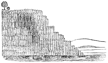
Name the stratified rocks. Describe gneiss. Mica slate. Sandstone. Conglomerate. Greensand. Describe the varieties of limestone.
What is dolomite? Of what does clay consist? Clay slate? What modifications does clay slate present? What is diluvium?
SECTION I.
What is the primary division of rocks?
Upon what principle are the unstratified rocks divided?
Upon what principle are the stratified rocks divided?
Why are the non-fossiliferous called metamorphic rocks?
Name the four classes of rocks.
SECTION II.
What is the most abundant plutonic rock?
How is its thickness ascertained?
What is its amount?
Where is it found?
What is its ordinary structure?
What peculiarity of structure facilitates the cleavage of granite?
Fig. 2.
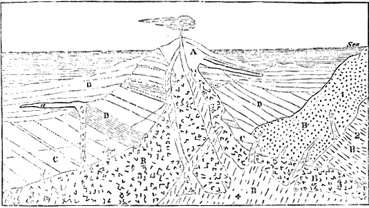
The granitic masses are generally deep below the surface; in what other position does granite appear?
Fig. 3. Fig. 4.
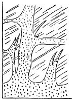
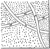
In what classes of rocks are granite veins found?
Were they all produced at the same time?
How is this demonstrated?
What is the relative position of the older and newer granites?
What other plutonic rocks occur in considerable quantities?
SECTION III.
Of what do volcanic rocks consist?
In what states are they ejected?
What are the principal varieties of lava, and how are they distinguished?
Why is the basaltic lava the last to be ejected?
How is the age of the volcanic rocks determined?
What are the three divisions of the volcanic rocks, as dependent upon age?
What is the proportion of the volcanic to other rocks?
How many active volcanoes exist?
Describe the eruptions of Kilauea.
Describe the eruption in Iceland in 1783.
What are the dimensions of Mount Ætna, and how has it been produced?
How are the tertiary lavas known to be such?
Where have they been most studied?
What is the evidence that these rocks in France are volcanic?
Have these lavas been produced within the historic period?
Fig. 5.
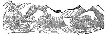
Were they produced at an early period in the earth’s history?
Give the evidence that their activity was long-continued.
Fig. 6.
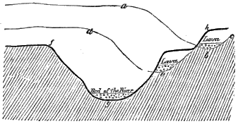
What is the form of the earlier volcanic rocks?
What circumstances distinguish the trappean from other volcanic rocks?
What are some of the prominent localities of the trappean rocks?
How do they occur in the islands west of Scotland?
How in the valley of the Connecticut river?
SECTION IV.
What is the lowest metamorphic rock?
Describe it.
How does mica slate differ from gneiss?
Is it well distinguished from argillaceous slate?
What is the third rock in the metamorphic series?
Why is it difficult to determine the upper limit of this series?
Why do the principal rocks of this series occur in the order here given?
What other rocks may take the place of these principal rocks?
Where do the metamorphic rocks occur?
What is their thickness and amount?
SECTION V.
How many systems of fossiliferous rocks are there, and what are they?
What other system is provisionally introduced?
What is its position?
Fig. 7.
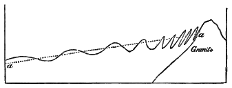
Describe it.
What materials of value are obtained from this system?
Fig. 8.
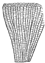
What fossils does it contain?
In what localities is it found?
What explanation, in reference to these rocks, is given by those who deny that they constitute a distinct system?
Fig. 9. 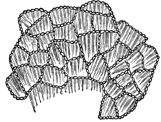
|
Fig. 10. 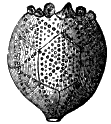
|
In what respects does the State of New York present the best facilities for studying the Silurian system?
Describe the Champlain division.
Fig. 11.

The Ontario division.
The Helderberg division.
Fig. 12. 
|
Fig. 15. 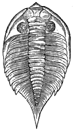
|
|
Fig. 13. 
|
Fig. 14. 
|
Fig. 16. 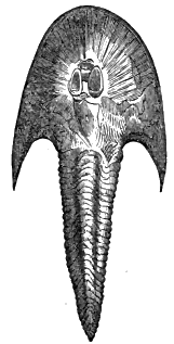
|
Describe the Erie division.
What are the fossils of this system?
Fig. 17.
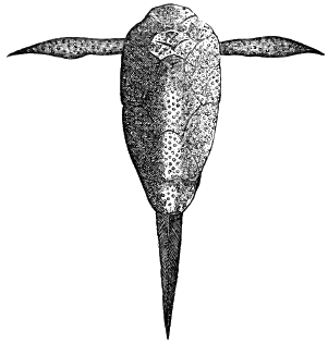
Describe the Crinoidea.
The Cephalopoda, and the two forms.
Fig. 18.
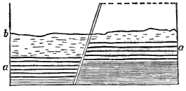
The Trilobite.
What higher forms of animal life existed during the silurian period?
The geographical range of the system?
Of what does the Old Red Sandstone consist?
Describe its three divisions.
What are its fossils?
Fig. 19.
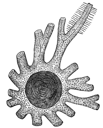
Describe the fishes of that period.
What was the peculiarity of the Pterichthys?
Of the Cephalaspis?
Where are the rocks of this system found?
How is the carboniferous system divided?
Describe the carboniferous limestone.
What ores are found in it?
Describe, its fossils.
Describe the millstone grit.
Of what do the coal measures consist?
How does the ironstone occur?
Describe the coal beds.
How is the continuity of the strata interrupted?
What variations from this general type occur in the formation?
|
Fig. 20. 
|
Fig. 21. 
|
Describe the several varieties of coal.
How is the coal quarried?
Fig. 22.

What mineral springs occur in this formation?
To what uses is coal applied?
(The coal was deposited thousands of years ago, and has served no useful purpose, that we know of, till very recently. Its formation was planned and completed to meet a want which was not to be felt till the lapse of many ages. It is a notable instance of the wisdom and forethought,[170] as well as of the benevolence, of God.) In what does this prospective arrangement consist? What are the character and position of the fossils of the coal measures?
Fig. 23. 
|
Fig. 25. 
|
Fig. 24. 
|
Fig. 26.

What are the four most abundant forms?
Describe the Stigmaria. The Sigillaria. The Lepidodendron. The Calamite.
Where are the beds of coal found?
What is the fourth formation of rocks?
Into what two portions is it divided?
Of what does the Permian portion consist?
The Trias?
What minerals are found in this formation?
What springs?
Fig. 27.

Fig. 28.
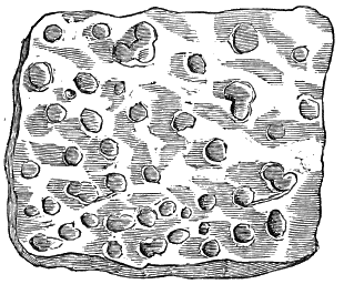
Fig. 29.

What fossils?
How are the fishes of the earlier and later portions distinguished?
What peculiarity of the red sandstones is mentioned?
By what kinds of animals were the tracks, which they contain, made?
Give localities of the new red sandstone.
What are the three divisions of the Oölitic system?
Fig. 31. 
|
Fig. 30. 
|
Fig. 32. 
|
Describe the Lias.
The Oölite.
The Wealden.
What are the general peculiarities of the system?
Fig. 33.

What are the fossil animals of the system?
By which class of fossil animals is the system characterized?
Fig. 34.

Describe the Ichthyosaurus. The Plesiosaurus. Pterodactyle. The Iguanodon.
Where is the system developed?
What are the divisions of the Cretaceous system?
How are the layers of chalk separated?
What is the geological position of the Neocomian system, and the greensand of this country?
What are the fossils of this system?
Fig. 35.

Fig. 36.
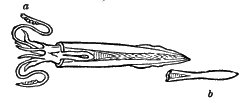
What the geographical range?
How are the tertiary deposits distinguished from the older formations?
Upon what principle is the tertiary system divided?
What are these divisions called, and what does each, name signify?
Fig. 37. 
|
Fig. 38. 
|
Fig. 39. 
|
Fig. 40. 
|
Fig. 41. Fig. 42.
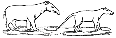
Fig. 43.

In what portion of the tertiary period was the drift deposited
What is the geographical range of the drift?
Of what does it consist?
What is the latest tertiary deposit?
What are the fossils of the tertiary system?
Describe the Paleotherium. The Anoplotherium. The Megatherium. The Mastodon. The Mammoth.
What other animals belonged to this period?
Where are the tertiary deposits found?
What formations are regarded as recent?
What formations of this class are accessible?
What others are in progress?
What are the fossils of this formation?
SECTION VI.
What is a fossil?
In what ways are they preserved?
When is a fossil said to be mineralized?
Describe the process of mineralization.
How is it proved that the removal of the organic matter and substitution of mineral particles are simultaneous?
Were animals created before vegetables?
How is this shown?
At what period was the vegetable growth the greatest?
What forms of animal life were most abundant during the earlier periods?
What vertebrated animals belonged to these periods?
What advance is made in the new red sandstone period?
During what period do the mammalia first appear in abundance?
During what geological period was man created?
How are the footprints and skeletons of human beings hi solid rocks accounted for?
Why are not fossils distributed uniformly through all the formations, and through all the parts of each formation?
In what does the importance of fossils consist?
How are the fresh-water and marine formations distinguished?
What circumstances render it difficult to identify rocks of the same age in different localities?
How are formations identified?
Was the work of creation one of short duration?
What was the last work of creation of which we have any geological evidence?
Why may we presume that no more species will be created?
Do all the animal and vegetable species which have been created still exist?
Fig. 44.
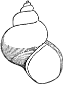
Fig. 46.  |
Fig. 45.  |
Fig. 47.  |
What causes are operating to destroy species?
SECTION VII.
How long has it been since the creation of the earth?
How does the amount of stratified rock indicate the great antiquity of the earth?
How does the stratification show the same thing?
What is the proof that the principal strata were deposited before the creation of man, and how does this fact bear upon the question of the antiquity of the earth?
Give the argument drawn from the successive creations and disappearance of animal and vegetable species.
The argument drawn from the amount of organic matter in the stratified rocks.
The argument from slow accumulation.
What is the general conclusion from these facts?
Why is this conclusion an important one?
What objection to it has been raised?
How is this objection answered?
What additional explanation is given?
SECTION I.
What is the deepest geological change of which we have any knowledge?
What are the reasons for supposing that the lowest stratified rocks are undergoing fusion?
Why are the lowest stratified rocks regarded as of mechanical origin?
What changes have they undergone?
SECTION II.
In what state were the stratified rocks deposited? What change have they undergone in this respect? How is the fissile structure produced? How is the cleavage structure produced?
Fig. 48.

What is the third class of changes?
What do fractures at the surface become by the erosion of water? How are caverns formed?
Describe a vein of segregation. A dike. A mineral vein. What is a fault?
Were the inclined strata thus deposited?
How is it proved that they have taken the inclined position since they were deposited?
What is the direction of the dip?
What lines form the angle of inclination?
What is the outcrop of inclined strata? The strike?
Fig. 49.
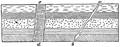
Fig. 50.
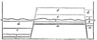
Fig. 51.
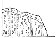
Fig. 52.
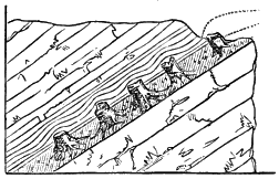
Fig. 53.
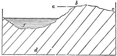
Describe an anticlinal axis. A synclinal axis. A valley of elevation. A valley of subsidence.
Fig. 54.
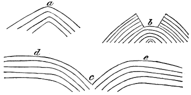
Fig. 55.
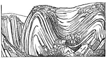
Fig. 56.

When are strata unconformable?
What other disturbances have taken place in the strata?
When did these various disturbances take place?
How is it known that there has been no period of universal disturbance?
SECTION III.
How is it known that the mountains have been covered by the ocean?
Fig. 57.
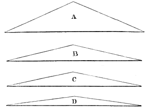
Fig. 58.
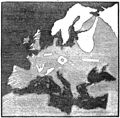
Were the granitic ridges thus covered?
Has the level of the sea been, to any considerable extent, fluctuating?
How, then, have the rocks, of which the mountain masses consist, been covered by sea?
Give the evidence that different mountains were elevated at different times.
Has the process of upheaval been sudden or gradual?
How are the mountain valleys, which have the direction of the mountain ranges, been produced?
Fig. 59.
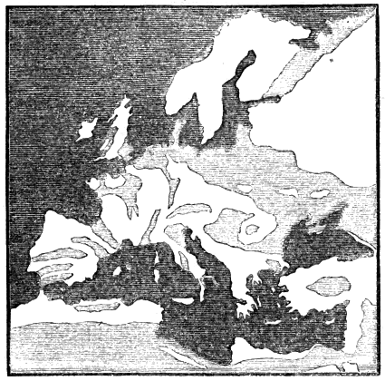
How is the existence of submarine mountains shown?
What is the movement by which continents are elevated?
State the evidence of the elevation of continents from the existence of elevated sea-beaches.
The evidence of the elevation of the coast of Maine.
The evidence of elevation from the existence of lakes.
From the geographical range of the older strata.
The evidence of the recent elevation of South America.
Of the rising of the north of Europe.
State the proof of subsidence from the occurrence of submerged forests.
Why are these changes but little observed?
Fig. 60.
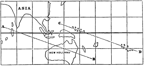
What are the grounds for asserting that a change of level is taking place over a large area in the Pacific and Indian Oceans?
Fig. 61.
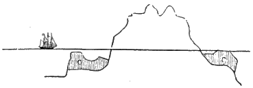
Fig. 62.
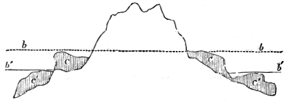
Fig. 63.
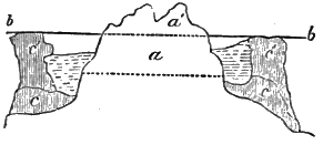
Fig. 64.
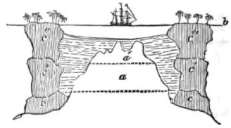
What is the present state of the coast of Greenland in this respect? Have the changes of level of the same place always been in the same direction?
Give the evidence of elevation and depression in South America. In Italy.
Fig. 65.
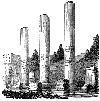
What general conclusion may we draw in respect to the stability of the earth’s surface?
To what extent can we ascertain the geography of past epochs?
What former relations of land and water are suggested as not improbable?
SECTION IV.
How can we estimate the denudation which the igneous rocks have suffered?
How do faults indicate the denudation of the stratified rocks?
How do valleys indicate denudations?
Describe the instance in Scotland.
What is the evidence of denudation in the Connecticut valley? How are valleys produced?
Fig. 66.

What is the condition of the surface rock in the colder portions of the temperate zones?
Fig. 67.
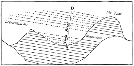
Fig. 68.
With what is the surface rock generally covered?
How are soils formed?
How may soils be improved?
What is necessary to render soils fertile?
SECTION V.
What means have we of judging of the climate of former periods?
What was the climate of the coal period?
What animal fossils indicate a former warm climate?
What evidence that Siberia once enjoyed a milder climate?
Do similar indications appear in the southern hemisphere?
When has the climate of the earth been most uniform?
Has the climate been growing gradually colder to the present time?
What is the evidence of a somewhat recent period of intense cold?
What recent local changes of climate are mentioned as having occurred?
SECTION VI.
State the general advantages of geological changes.
By what changes have the coal-beds and other stratified rocks become accessible?
What advantage from these elevating forces in reference to the granitic rocks?
Fig. 69.
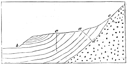
How do these changes affect our means of knowing the structure of the earth?
Explain the origin of springs, wells, and artesian wells?
By what changes have the metallic ores become accessible?
In what light, then, are we to regard disturbances of geological structure?
What is the object of the preceding chapters?
How can we arrive at a knowledge of the causes which have produced geological phenomena?
Have geological causes always operated with the same intensity?
How are the means of forming correct geological theories increasing?
SECTION I.
How does oxygen become an agent in the disintegration of rocks?
How does carbonic acid operate in the disintegration of rocks?
What is the effect of moisture and rain?
What is the effect of variations of temperature?
What other atmospheric causes are mentioned?
How do these causes become important?
What are some of their effects?
SECTION II.
What are the changes which are to be referred to chemical agency?
Mention some of the disturbances which give rise to chemical changes.
What are the principal effects of chemical action?
How is the cleavage structure accounted for?
Fig. 70.

Fig. 71.
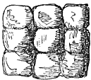
Mention instances which show that a cleavage may be established in a body in a solid state.
In it a crystalline arrangement of the particles of the mass?
What other divisional planes exist in rocks?
Mention instances of concretionary formations.
Why may not these concretions have been deposited as nodules?
How have these concretions been formed?
Mention instances of segregation without the concretionary structure.
How was the segregation in these instances effected?
How is the columnar structure produced?
What is the origin of the mineral veins which are first mentioned?
How is it shown that other veins are not injected?
How were these veins formed?
What is the force by which these molecular changes have been effected?
SECTION III.
In what ways are geological changes produced by human agency?
Of what are the organic remains, in rocks, the record?
What rocks contain organic materials in large quantity?
What is the most abundant organic product?
Explain the mode of growth of corals.
Give instances of extensive coral reefs.
What is the total amount of surface covered by the coral reefs?
SECTION IV.
What degree of importance is attached to water as a geological agent?
What are the sources of the sediment which water deposits?
Why is not the formation of the sedimentary rocks capable of being observed?
What is the first mode in which solid matter is taken up by water?
Why are the waters of the ocean saline?
What effect has the temperature of water in the solution of silex?
What effect has an alkaline condition of water?
Fig. 72.
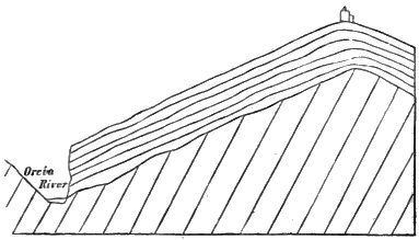
What rock is soluble in water charged with carbonic acid?
Give an instance of limestone formation from such solutions.
How do rivers furnish sediment for the stratified rocks?
What determines the position of rapids in rivers?
What is the effect of waterfalls on the abrading action of rivers?
What is the peculiarity of rock at Niagara which has prevented the fall from becoming a succession of rapids?
What other circumstance increases the abrading action of rivers?
What is the principal source of the sediment which is transported by rivers?
What is the annual amount of sediment furnished by the Kennebec? The Merrimac? The Mississippi? The Ganges?
What is the general tendency of these abrading forces?
What is the effect of waves upon the coast, when it consists of unsolidified materials?
Describe their effect upon rocky coasts.
How is the encroachment upon such coasts shown?
Fig. 73.
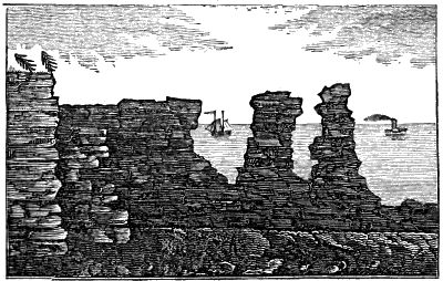
What is the effect of waves of less power?
How are marine currents produced?
How are they increased by the evaporation of the torrid zone?
What are the most important marine currents?
Which class of currents have the greater depth?
Upon what does the power of deep currents depend?
How would the effect of these currents be increased by earthquakes?
Where will the effects of these currents be greatest?
Mention instances of these effects.
Fig. 74.
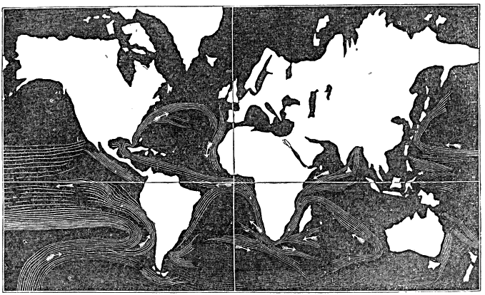
What must be the effect of such currents as the Gulf-stream and Mozambique channel?
Mention, generally, the effects of these currents.
Why does detrital matter remain suspended in the water of rivers?
How is the coarse and fine sediment separated?
Why do river currents extend some distance into the sea?
What effect does this have in distributing the sediment which the rivers furnish?
Upon what does the transporting power of marine currents depend?
When a river enters a lake, why is its sediment deposited?
Describe the effect.
When is sediment deposited in the beds of rivers?
Describe the effects of this deposition.
Where is most of the sediment deposited?
Give the area of some delta deposits.
How do the deep-sea deposits now forming compare in extent with the earlier formations?
State the several circumstances by which a succession of deposits would be arranged in strata.
How are those differences produced upon which the separation into independent formations depends?
Why are marine deposits nearly horizontal?
Fig. 75.

How are the irregular stratifications produced?
What peculiarity in the fossils will distinguish the lacustrine and marine deposits?
What peculiarity in reference to fossils will characterize the deep-sea deposits?
How is coal shown to be of vegetable origin?
Why will the drift wood of the sea accumulate in particular localities, and why will it sink?
Why will it become buried beneath earthy matter?
How is it known that wood thus buried will, at length, become lignite?
How is lignite converted into mineral coal?
What is the proof of it?
Have beds of coal been formed at other periods, besides the carboniferous?
Is it probable that coal-beds are now forming?
How did the flora of the carboniferous period differ from the existing flora?
Fig. 76.
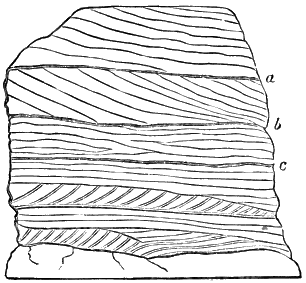
Are the alternations of the earthy and coal strata satisfactorily explained?
In what portions of the geological series are the deposits of salt found?
Where is saline matter principally stored?
Explain the conjectural formation of salt in the Mediterranean Sea.
What form do rocks take when deposited from a chemical solution?
How is sand or gravel solidified by the infiltration of mineral waters?
What is the effect of drying upon the solidification of rocks?
What is the effect of pressure?
What of heat?
SECTION V.
What is a glacier?
What is the extent of the glaciers of the Alps?
What change does the mass of snow in the higher valleys of the glacier mountains undergo?
What is the source of supply to the glacier?
What is the cause of the motion of the glacier?
What is the usual annual motion?
Why will the glacier melt but little at its under side?
Where will the waste at the surface just equal the addition?
What circumstances vary the position of the terminus of the glacier?
Fig. 77.
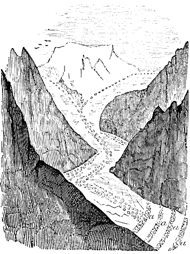
What, besides snow and ice, enters into the composition of a glacier?
How are these materials supplied?
How is a lateral moraine formed?
What effect has the motion of the glacier on the rocky surface over which it passes?
What is the material by which this effect is produced?
How is the terminal moraine produced?
How may the moraines on the Jura Mountains be explained?
How has it been proposed to explain the striated surfaces of rocks found in the north of Europe and America?
What is the objection to this extension of the glacier theory?
How does the ice accumulate along the coast in high latitudes to form icebergs?
Why does it ultimately separate from the shore?
How does it become freighted with earthy matter?
In what direction do the icebergs float, and why?
What are the dimensions of an iceberg, estimated from the part that is visible?
Fig. 78.
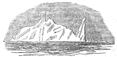
Where does the mass of ice increase, and where diminish?
What will be the effect of its melting?
How is it supposed that icebergs may have striated the rocky surface?
What is probably the condition of the bed of the seas over which icebergs now float?
Has the north of Europe and America been so depressed, during a period comparatively recent, as to admit of this explanation of the drift phenomena?
SECTION VI.
What is the condition of the interior of the earth with respect to heat?
How do the observations made in deep mines and wells prove this?
How far is the temperature influenced from the surface?
What is the general law of increment of temperature?
At what depth would most mineral substances be melted?
How is this conclusion confirmed?
What was probably the original state of the mass of the earth?
What other explanation may be given of this interior heat?
What is the elastic force upon which volcanic phenomena depend?
Upon what does the fluidity of lava depend?
Upon what does its porous structure, when cooled, depend?
Why are volcanoes situated near the sea?
Describe the principal lines of volcanic activity.
What are the forces tending to repress the elasticity of the mass below?
What will be the effect when the elastic is greater than the repressing force?
What produces the phenomena of the earthquake?
What is a volcano?
Why are volcanoes generally arranged a linear direction?
Under what circumstances will a new volcano be formed?
What instances are cited?
How is a volcanic cone formed?
Why are lateral cones produced?
How are volcanic cinders formed? Scoriæ? Volcanic glass?
Fig. 79.
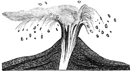
Give instances of fractures as results of volcanic action. How are dikes formed?
Fig. 80.

By what agency have the changes in the metamorphic rocks been effected?
Give the instance of metamorphic action from intrusive granite in Norway.
What instance is given as occurring in New Hampshire?
Give the experiment by which it is shown that these changes will result from a high temperature.
Fig. 81.
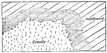
What must be the condition of the lowest stratified rocks in regard to temperature?
Why is not the stratification destroyed?
What changes are produced by this high temperature?
Explain the connection of denudation and earthquake action.
What is the evidence that the surface of the earth is thrown into undulations during earthquakes?
What is the velocity of these undulations?
Give the instance which occurred in Chili.
To what parts of the earth are these undulations limited?
What condition of the surface may be regarded as resulting from this cause?
What is the class of rocks most obviously referable to volcanic agency?
How do the trap rocks differ from ordinary lavas?
Why are they not vesicular?
Why more crystalline?
Why were cones never formed?
What is the proof that the granitic rocks have once been in a melted state?
Why does not the mass of melted rock below the surface retain permanently its liquid form?
Why does it, on cooling, become more crystalline than lava?
State the process by which mountains are formed.
By what law does the elevating force accumulate?
Why, then, is the process of elevation spasmodic, and not constant?
How is the inclined position of strata produced?
How are strata brought into a vertical position over large areas?
Why do subsidences occasionally follow these movements of elevation? Mention instances.
Fig. 82.
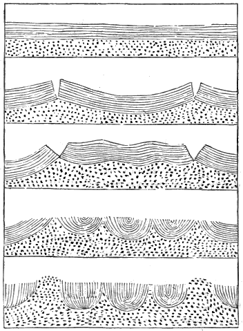
What explanation is suggested of deep and extensive chasms?
What conditions must exist together, in the force by which continents are produced?
What cause fulfils these conditions?
What is the proof that the temperature under given localities is variable?
What will be the result of these variations?
What is the law of expansion of rocks, as obtained by experiment?
What amount of change of level may be thus accounted for?
What circumstances would probably increase this amount?
What amount of vertical movement must be accounted for?
Why must these changes of level be very slow?
Under what conditions would there be no change of level?
Is it probable that these conditions exist to any great extent?
Why, then, are not the changes of level observed?
Why is the bed of the sea most likely to experience the change of elevation?
Why are the continents most favorably situated to undergo depression?
What are the sources of heat upon which climate depends?
Does the interior temperature sensibly affect the present climates?
What cause may be assigned for the changes of climate which are known to have taken place?
What are the relations of land by which the highest temperature would be produced?
How would this distribution of land affect the temperature of the waters of the ocean?
What would result if the opposite relations of land and water existed?
What confirmation of these conclusions is drawn from the existing climates of different parts of the earth?
Is there any reason to suppose that the relations of land and water which would have produced a warmer climate in former times did not exist?
Transcriber’s Notes
The following is a transcript of the Silurian System table on page 34 for those who are using screen readers.
Key to Divisions
----------------
C  - Cambrian Rocks.
S  - Silurian System.
D  - Devonian.
Ch - Champlain Division.
On - Ontario Division.
He - Helderberg Division.
Er - Erie Division.

   Divisions as recognized  Divisions as recognized  Pennsylvania  Ohio.
   by English Authors.      by the New York          and Virginia.
                             Geologists.
    /--------^----------\ /-----------^-----------\ /-----^----\ /---^----\
    { Upper Cambrian    {  { Potsdam Sandstone.     } No. 1.
    {                   {  {
  C { Rocks, of Sedgwick{  { Calciferous Sandrock.  }
    {                   {  { Birdseye Limestone.    } No. 2.   }
    { (probably).       {Ch{ Trenton Limestone.     }          } Blue
                        {  {                                   } Limestone
    { Llandeilo Flags.  {  { Utica Slate.           }          } and Marl.
    {                   {  {                        } No. 3.   }
    {                      { Hudson River Group.    }
    {                   {
    {                   {  { Gray Sandstone.        } No. 4.
    {                   {  { Oneida Conglomerate.   }
    {                   {On{
    { Caradoc Sandstone.{  { Medina Sandstone.      } No. 5.
    {                   {  { Clinton Group.         }
    {                      { Niagara Group.
    {                   {                           }           }
    {                   {  { Oneida Salt Group.     }           :
    {                   {  { Water-lime Group.      }           :
    {                   {  { Pentamerus Limestone.  } No. 6.    :
    {                   {  { Delthyris Shaly        }           :
    {                   {  {   Limestone.           }           :
  S {                   {  { Encrinal Limestone.    }           : Cliff
    { Wenlock Rocks.    {He{ Upper Pentamerus       }           :
    {                   {  {   Limestone.                       : Limestone.
    {                   {  { Oriskany Sandstone.    }           :
    {                   {  {                        } No. 7.    :
    {                   {  { Cauda-Galli Grit.      }           :
    {                   {  { Schoharie Grit.        }           :
    {                   {  { Onondaga Limestone.      Wanting.  :
    {                   {  { Corniferous Limestone.   Wanting.  }
    {                                               }
    {                   {  { Marcellus Shales.      }           } Black
    {                   {  { Hamilton Group.        }           } Slate.
    { Upper and Lower   {  {                        } No. 8.
    {                   {  { Tully Limestone.       }
    { Ludlow Rocks and  {Er{                        }
    :                   {  { Genesee Slate.
  D : the Devonian      {  {                        }
    :                   {  { Portage Group.         } No. 9.   } Waver
    : System.           {  {                        }          }
    {                   {  {Chemung Group.          }          } Sandstone.