*** START OF THE PROJECT GUTENBERG EBOOK 74316 ***
AMERICAN SCIENCE SERIES—ADVANCED COURSE
GEOLOGY
BY THOMAS C. CHAMBERLIN AND ROLLIN D. SALISBURY
Heads of the Departments of Geology and Geography, University of Chicago
Members of the United States Geological Survey
Editors of the Journal of Geology
IN THREE VOLUMES
VOL. I.—GEOLOGIC PROCESSES AND THEIR RESULTS
SECOND EDITION, REVISED
NEW YORK HENRY HOLT AND COMPANY 1909
Copyright, 1904, BY
HENRY HOLT AND COMPANY
PRINTED IN THE U. S. A.
iii
PREFACE.
In the preparation of this work it has been the purpose of the authors
to present an outline of the salient features of geology, as now
developed, encumbered as little as possible by technicalities and
details whose bearings on the general theme are unimportant. In common
with most writers of text-books on geology, the authors believe that
the subject is best approached by a study of the forces and processes
now in operation, and of the results which these forces and processes
are now bringing about. Such study necessarily involves a consideration
of the principles which govern the activities of geologic agencies.
These topics are presented in Volume I, and prepare the way for the
study of the history of past ages, which is outlined in Volume II.
The general plan of the work has been determined by the experience of
the authors as instructors. Little emphasis is laid on the commonly
recognized subdivisions of the science, such as dynamic geology,
stratigraphic geology, physiographic geology, etc. The
treatment proceeds rather from the point of view that the science is a
unit, that its one theme is the history of the earth, and that
the discussions of dynamic geology, physiographic geology, etc., apart
from their historical bearing, lose much of their significance and
interest. The effort has, therefore, been to emphasize the historical
element, even in the discussion of special themes, such as the work of
rivers, the work of snow and ice, and the origin and descent of rocks.
This does not mean that phases of geology other than historical have
been neglected, but it means that an effort has been made to give a
historical cast to all phases of the subject, so far as the topics
permit.
Throughout the work the central purpose has been not merely to set
forth the present status of knowledge, but to present it in such a way
that the student will be introduced to the methods and spirit of the
science, led to a sympathetic interest in its progress, and prepared to
receive intelligently, and to welcome cordially, its future advances.
Where practicable, the text has been so shaped that the student mayiv
follow the steps which have led to present conclusions. To this end
the working methods of the practical geologist have been implied as
frequently as practicable. To this end also there has been frankness of
statement relative to the limitations of knowledge and the uncertainty
of many tentative conclusions. In these and in other respects, the
purpose has been to take the student into the fraternity of geologists,
and to reveal to him the true state of the development of the science,
giving an accurate and proportionate view of the positive knowledge
attained, of the problems yet unsolved, or but partially solved, and of
solutions still to be attained.
The theoretical and interpretative elements which enter into the
general conceptions of geology have been freely used, because they
are regarded as an essential part of the evolution of the science,
because they often help to clear and complete conceptions, and
because they stimulate thought. The aim has been, however, to
characterize hypothetical elements as such, and to avoid confusing the
interpretations based on hypothesis, with the statements of fact and
established doctrines. Especial care has been taken to recognize the
uncertain nature of prevalent interpretations when they are dependent
on unverified hypotheses, especially if this dependence is likely to be
overlooked. If this shall seem to give prominence to the hypothetical
element, it should also be regarded as giving so much the more emphasis
to that which is really trustworthy, in that it sets forth more frankly
that which is doubtful. Hypothetical and unsolved problems have been
treated, so far as practicable, on the multiple basis; that is,
alternative hypotheses and alternative interpretations are frequently
presented where knowledge does not warrant positive conclusions.
In many cases the topics discussed will be found to be presented in
ways differing widely from those which have become familiar. In some
cases, fundamentally new conceptions of familiar subjects are involved;
in others, topics not usually discussed in text-books are stated with
some fullness; and in still others, the emphasis is laid on points
which have not commonly been brought into prominence. Whether the
authors have been wise in departing to this extent from beaten paths,
the users of the volumes must decide.
The work is intended primarily for mature students, and is designed to
furnish the basis for a year’s work in the later part of the collegev
course. By judicious selection of material to be presented and omitted,
the volumes will be found useful for briefer courses, and by the use of
the numerous references to the fuller discussions of special treatises,
they may be made the basis for more extended courses than are commonly
given in undergraduate work. The attempt has also been made to make the
volumes readable, in the belief that many persons not in colleges or
universities will be interested in following a connected account of the
earth’s history, and of the means by which that history is recorded and
read. Antecedent elementary courses in geology will not be necessary to
the use of these volumes, though such courses may be helpful.
The arrangement of themes adopted is such as to bring to the fore
processes with which all students are immediately in contact, and
which are available for study at all seats of learning. The commoner
geologic agents, such as the atmosphere and running water, have been
elaborated somewhat more fully than is customary, and the common
rather than the exceptional phases of the work of these agents have
been emphasized, both because of their greater importance and their
universal availability. The text has been so shaped as to suggest field
work in connection with these topics especially, since work of this
sort is everywhere possible.
After the preliminary outline, which is intended to give some idea of
the scope of the science, and of its salient features, and to show the
relations of the special subjects which follow, the order of treatment
is such as to pass from the commoner and more readily apprehended
portions of the subject to those which are less readily accessible and
more obscure. Following the same general conception, the treatment of
the topics is somewhat graded, the earlier chapters being developed
with greater simplicity and fullness, while the later are somewhat more
condensed.
Many acknowledgments are made in the text and foot-notes, but it
is impossible to adequately acknowledge all the sources which have
been drawn upon, since the whole body of literature has been laid
under contribution. The authors especially acknowledge the generous
assistance of Professor J. P. Iddings in connection with the chapter on
The Origin and Descent of Rocks; of Dr. F. R. Moulton, Professor C. S.
Slichter, Professor L. M. Hoskins, Mr. A. C. Lunn, and Mr. W. H. Emmons
in connection with mathematical problems; of Professor C. R.vi Barnes in
connection with the geologic functions of life; and of Professor Julius
Stieglitz in connection with chemical subjects.
The illustrations have been selected from numerous sources, which are
usually acknowledged in the text. Especial acknowledgment is due to the
U. S. Geological Survey for the use of numerous photographs and maps,
and to Mr. G. A. Johnson, who has made many of the drawings reproduced
in Volume I. The authors are under even larger obligations for
assistance in the preparation of Volume II, for which acknowledgment
will be made in the proper place.
Irregularities, 10. Epicontinental seas, 11. Diversities of surface, 12.
The surface mantle of the lithosphere, 12. The crust of the lithosphere, 13. The interior, 14.
Varieties of rock in crust, 14. Stratified rocks, 14. Conformability, 15. Relative ages, 15.
The crystalline rocks, 16. Four great sedimentary eras, 17. The Archean complex, 18.
Transportation and deposition of dust, 22. Transportation and deposition of sand, 25.
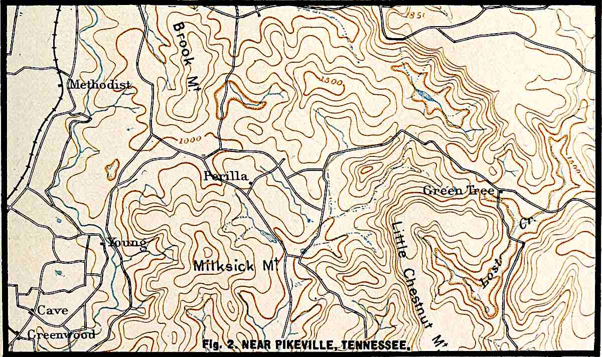
Formation of dunes, 26. Shapes of dunes, 26. The topographic map, 30. Topography
viiiof dune areas, 32. Migration of dunes, 33. Distribution of dunes, 35.
Wind ripples, 37. Abrasion by the wind, 38. Effects of wind on plants, 40. Indirect effects of the wind, 41.
By the growth of gullies, 63. Limits of growth, 67. The permanent stream,
70. Other modes of valley development, 73. Structural valleys, 77.
The courses of valleys, 77. The development of tributaries, 78.
Due to inequalities of hardness, 204. Normal flood-plain terraces,
205. Flood-plain terraces due to other causes, 208. Discontinuity of terraces,
209. Termini of terraces, 210.
Conditions influencing descent of rain-water, 213. Supply of ground-water not
altogether dependent on local rainfall, 215. Ground-water surface—water table, 215. Depth
to xwhich ground-water sinks, 216. Movement of ground-water,
220. Amount of ground-water, 221. Fate of ground-water, 221.
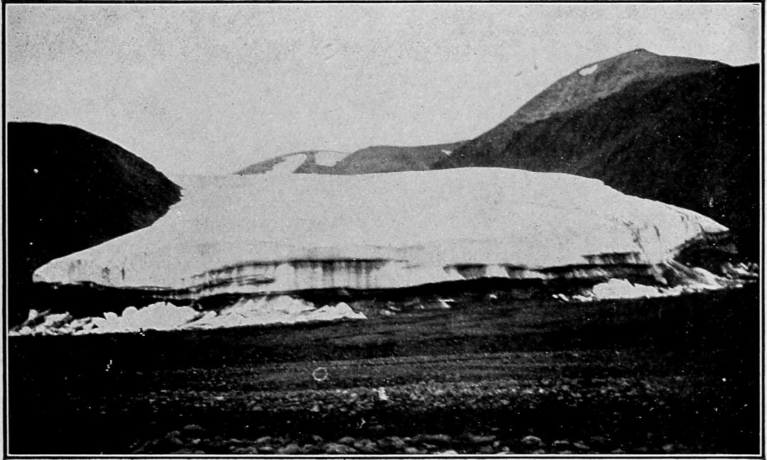
The winter wave, 274. The summer wave, 276. The temperature of the bottom,
276. Temperature of the interior of the ice, 277. Compression and friction as causes of heat,
278. Summary, 279. Movement under low temperature, 279. Evaporation, 279. Drainage, 280.
Getting load, 282. Conditions influencing rate of erosion, 283. Summary, 286.
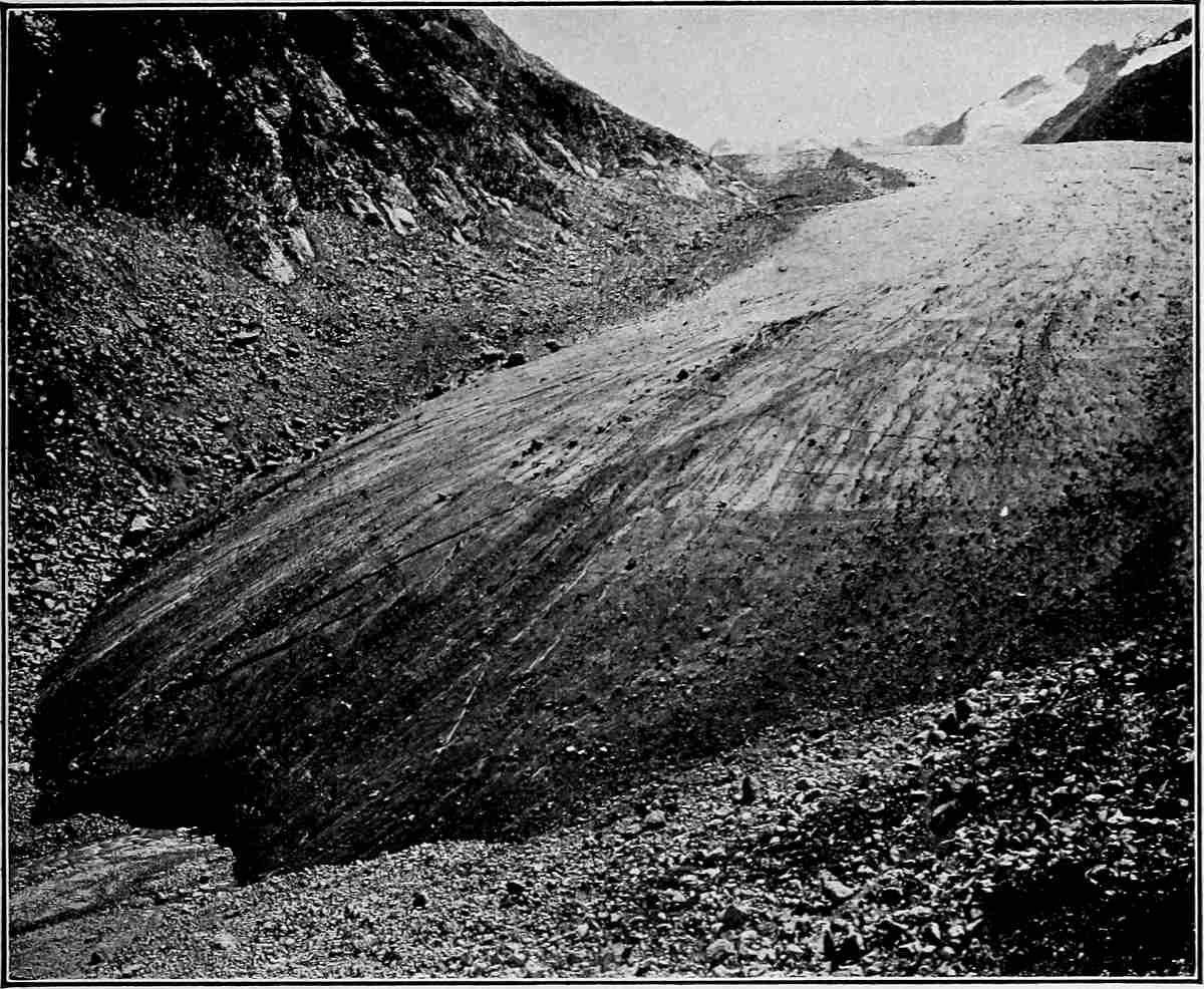
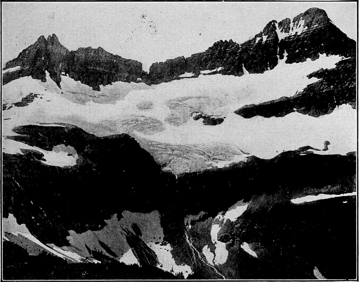
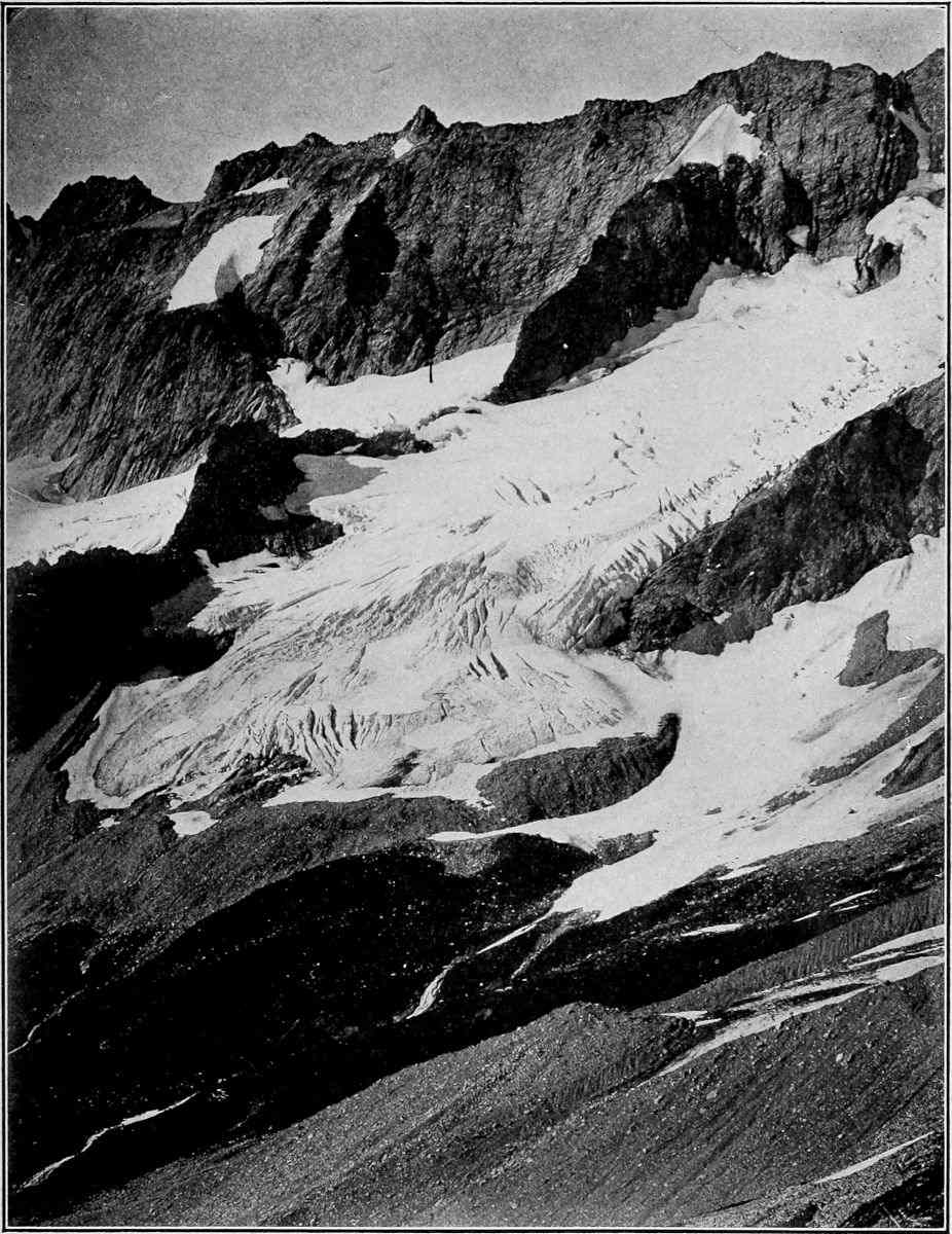
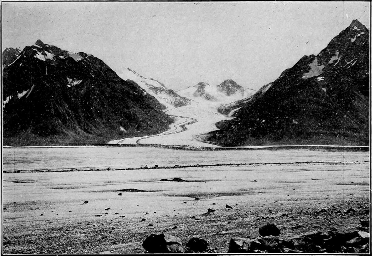
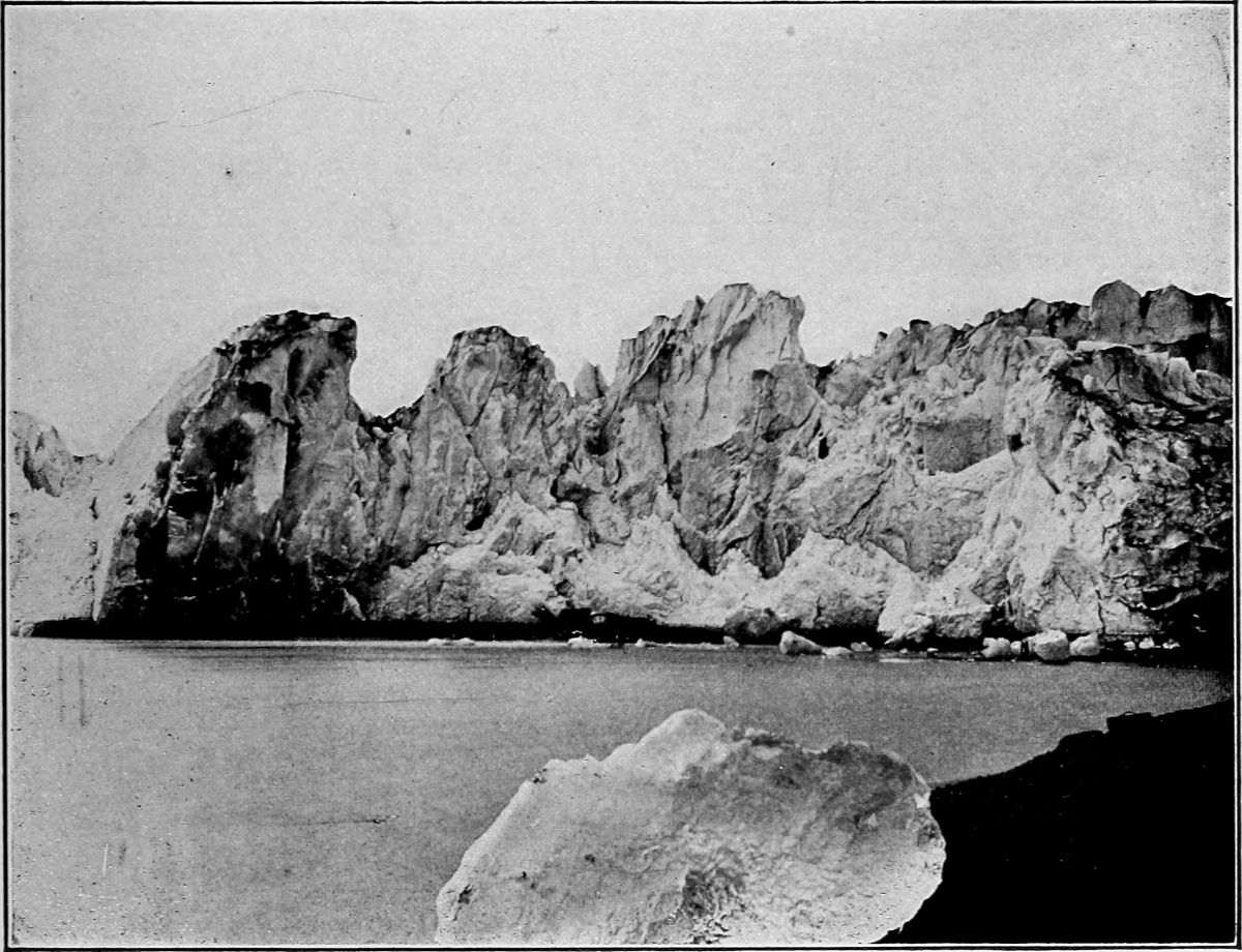
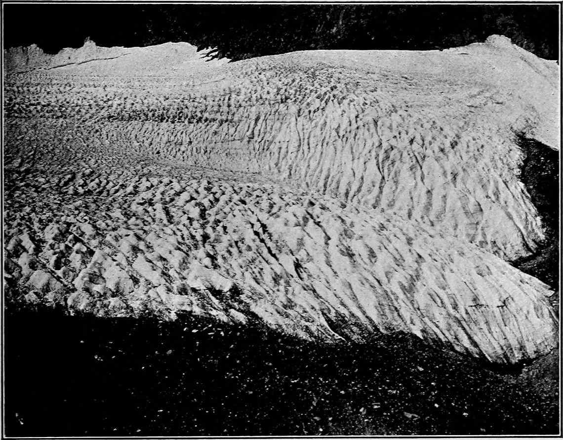
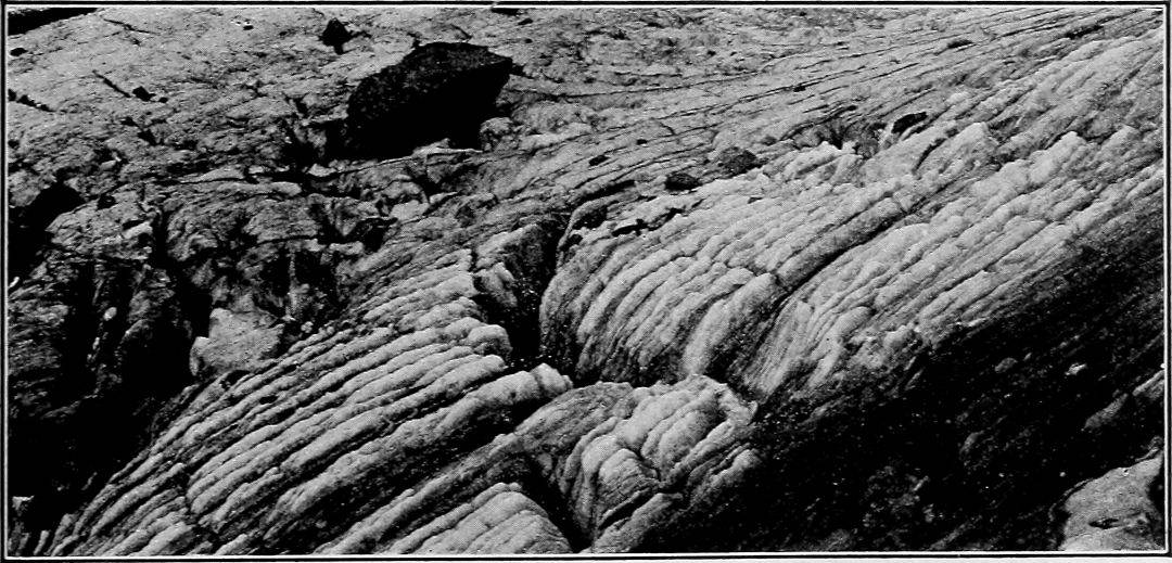
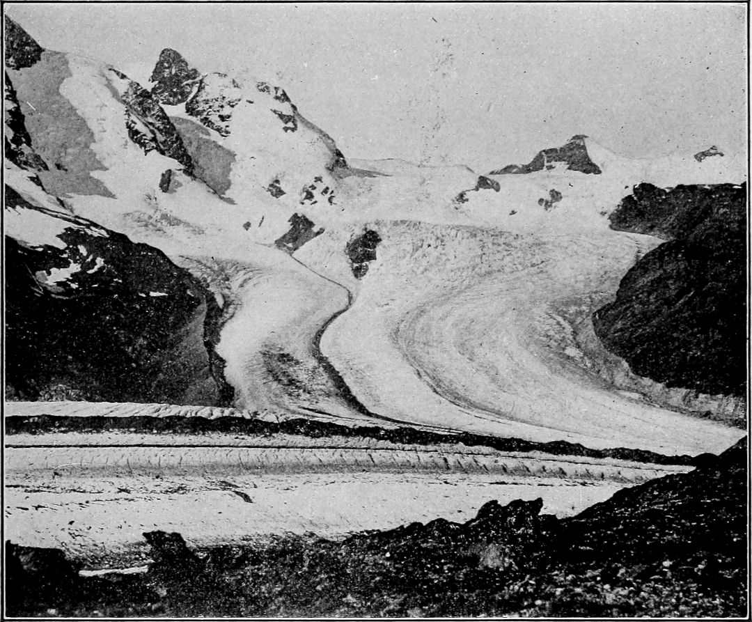
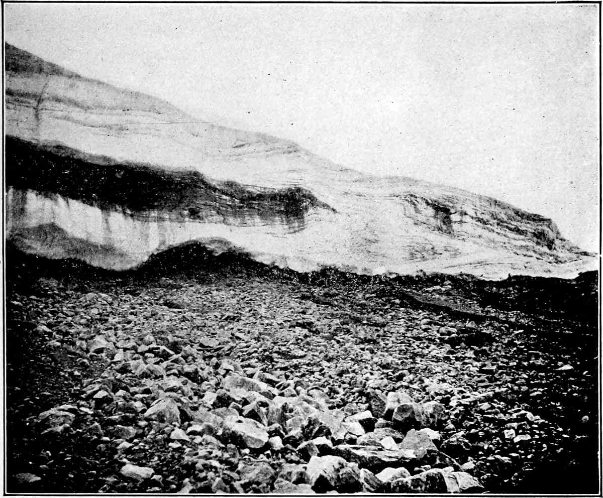
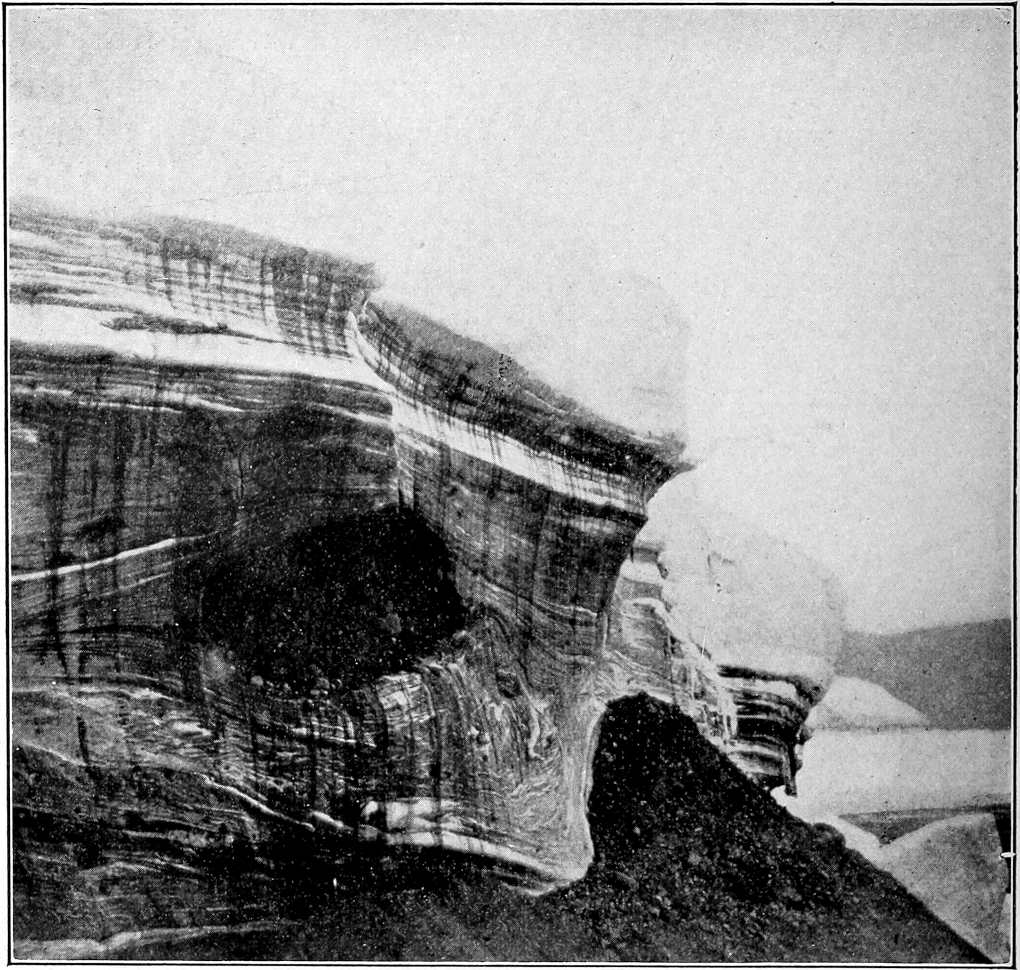
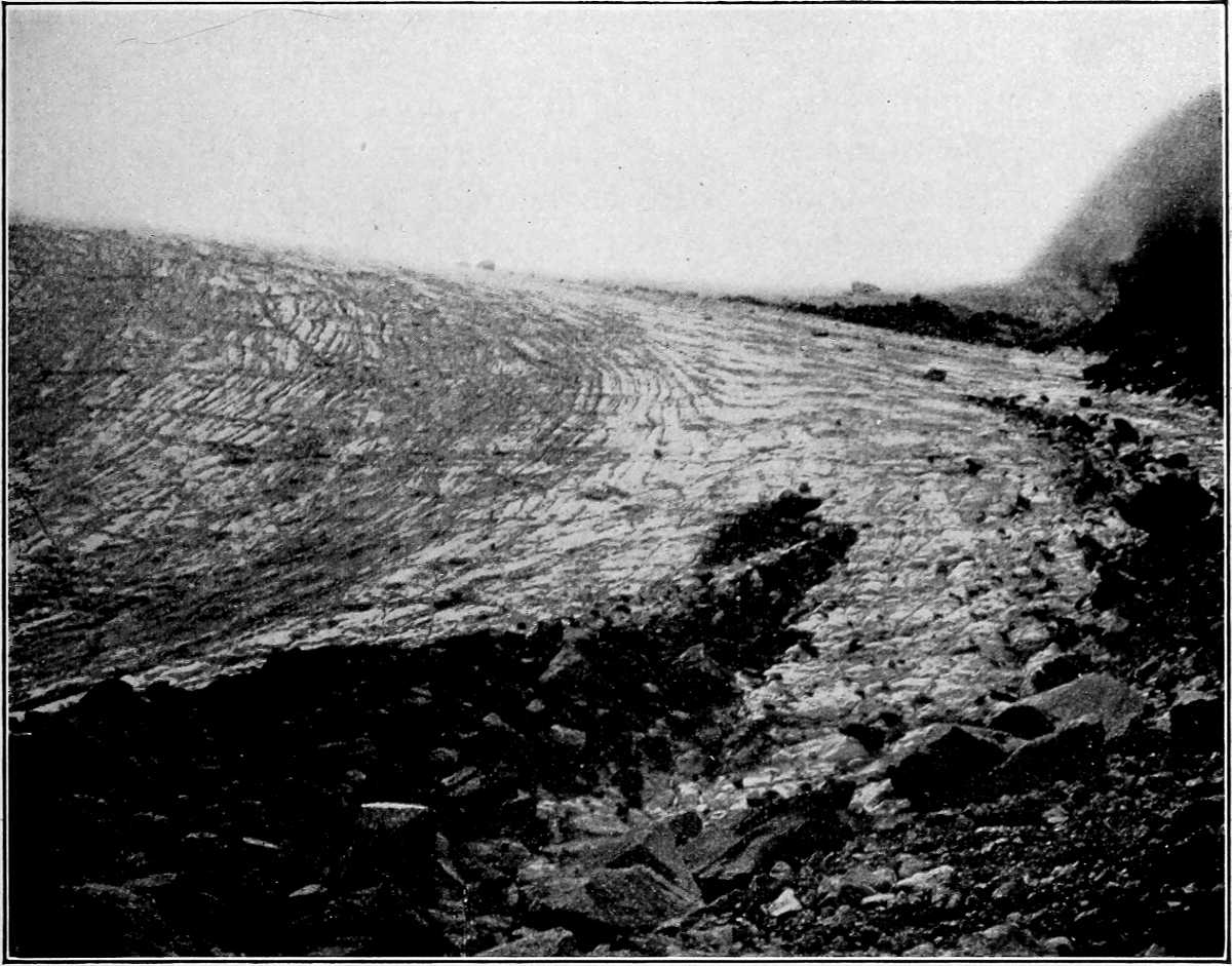
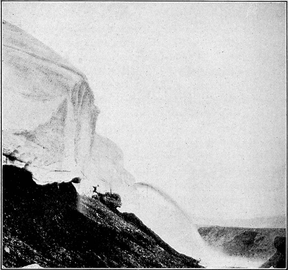
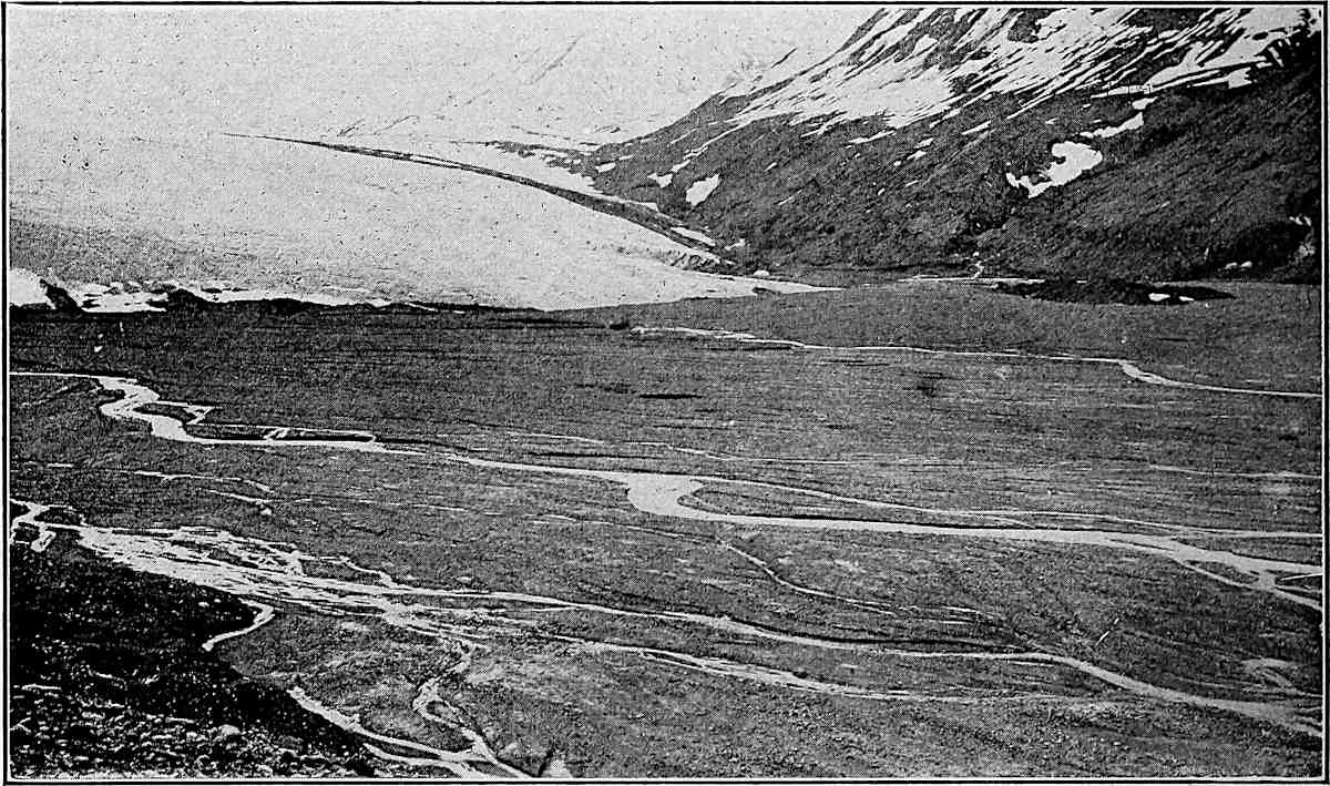
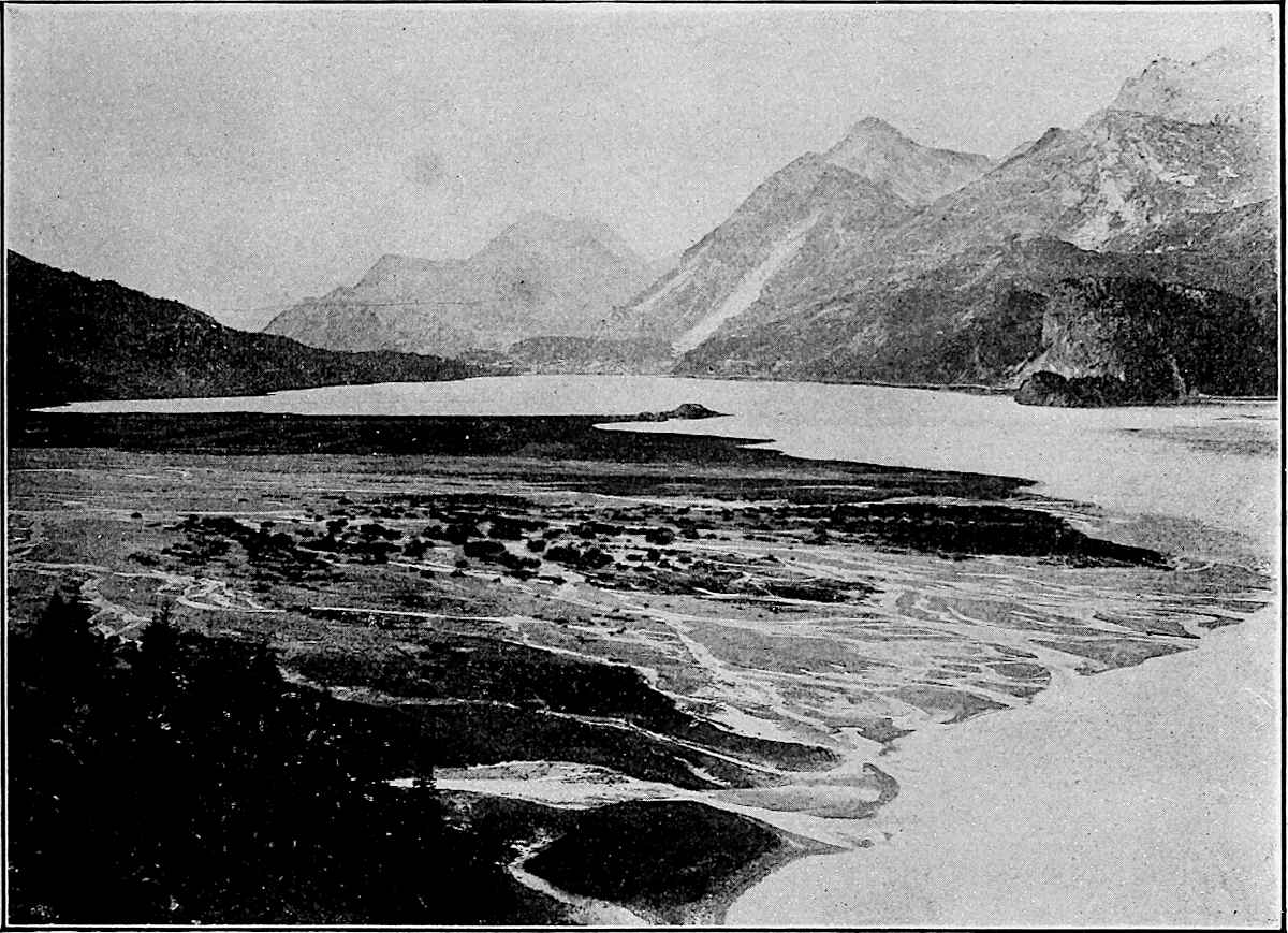
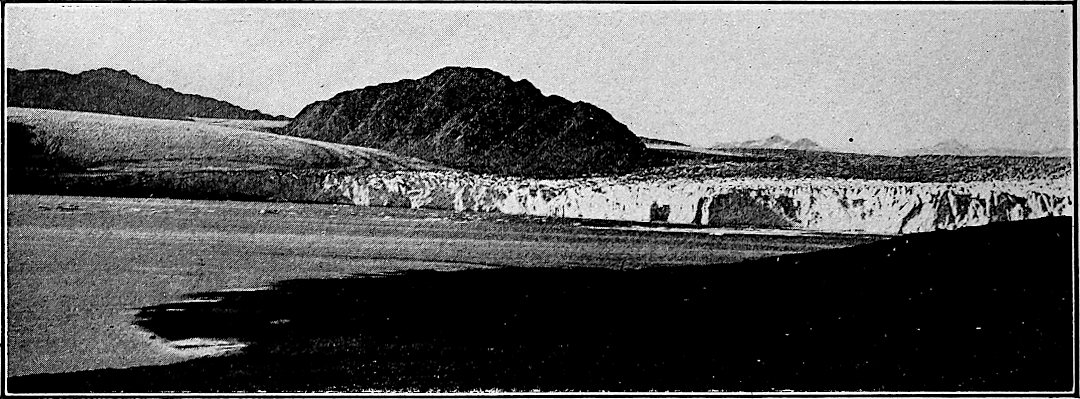
Varied nature of glacial débris, 286. The topographic effects of glacial erosion, 287. Fiords,
290. The positions in which débris is carried, 290. Transfers of load, 292. Wear of drift
in transit, 298.
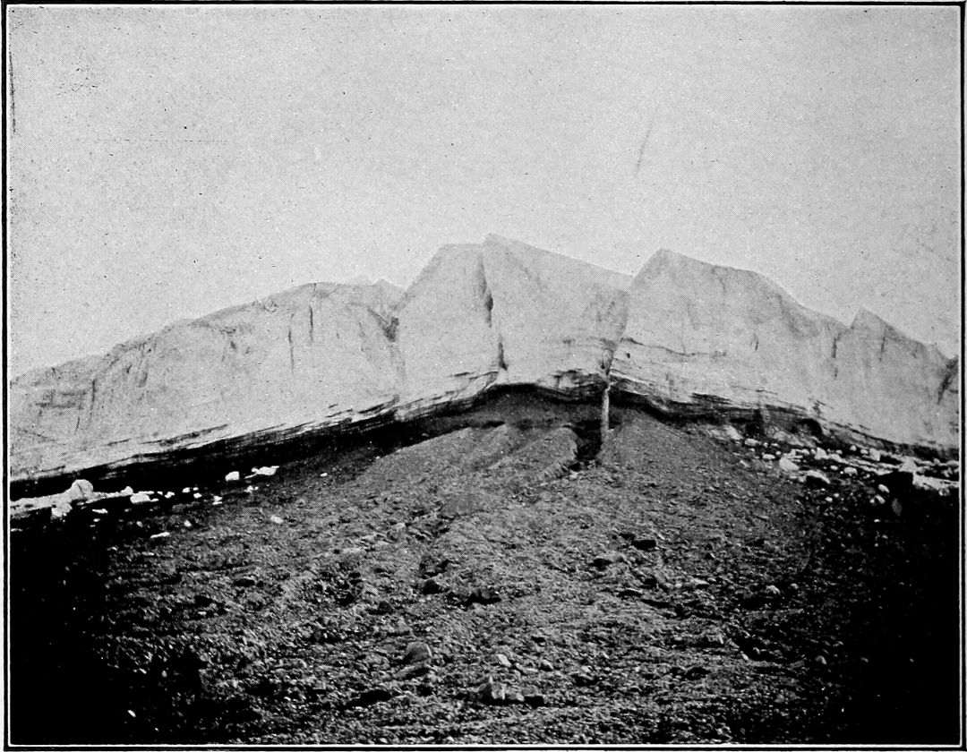
The terminal moraine, 301. The ground moraine, 301. The lateral moraines,
302. Distinctive nature of glacial deposits, 304. Glaciated rock surfaces, 304.
Differences in density and their results, 335. Differences in level and their results.
335. Movements generated by xiiwinds, 336. Movements
generated by attraction, 322. Aperiodic movements, 338. Summary, 339.
Changes taking place in lakes, 387. Lacustrine deposits, 388. Extinct lakes,
388. Lake ice, 389. Saline lakes, 391. Indirect effects of lakes, 392. Composition
of lake waters, 392.
Leading elements, 396. Union of elements, 397. Formation of minerals, 397.
Sources of complexity, 398. The xiiileading minerals of
igneous rocks, 399. The feldspathic minerals, 400. The ferromagnesian minerals, 400. Summary
of salient facts, 401.
The phanerites, 412. The granites, 413. The syenites, 415. The diorites,
416. The gabbros, 416. The peridotites, 416. The basalts, 417. The dolerites,
417. General names, 418.
Oxidation and deoxidation, 427. Solution and deposition, 427. Hydration and
dehydration, 428. Carbonation and decarbonation, 429. Molecular rearrangements, 431.
Induration under ordinary pressures and temperatures, 432. Cavity filling,
436. Fissure filling; veins, 437. Solution as well as deposition, 437. Concretions,
438. Replacements and pseudomorphs, 439. Incipient crystallization, 439.
Slaty structure, 441. Foliation, schistosity, 443. Metamorphism by heat,
446. Metamorphism by heat and lateral xivpressure,
448. Deep-seated metamorphism, 449. Completion of the rock cycle, 449.
Concentration, 474. Exceptional and doubtful cases, 474. Original distribution,
475. Magmatic segregation, 475. Marine segregation and dispersion, 476. Origin of ore regions,
477. Surface residual concentration, 478. Purification and concentration, 478. Concentration
by solution and reprecipitation, 479. Location of greatest solvent action, 480. Short-course action,
481. Long-course action, 481. Summary, 483. The influence of contacts, 484. The effect of
igneous intrusions, 484. The influence of rock walls, 484.
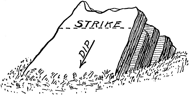
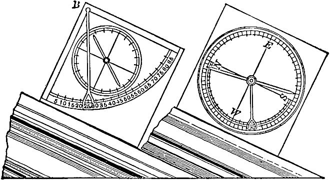
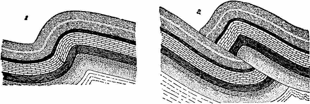
Inclination and folding of strata, 500. Joints, 510. Sandstone dikes,
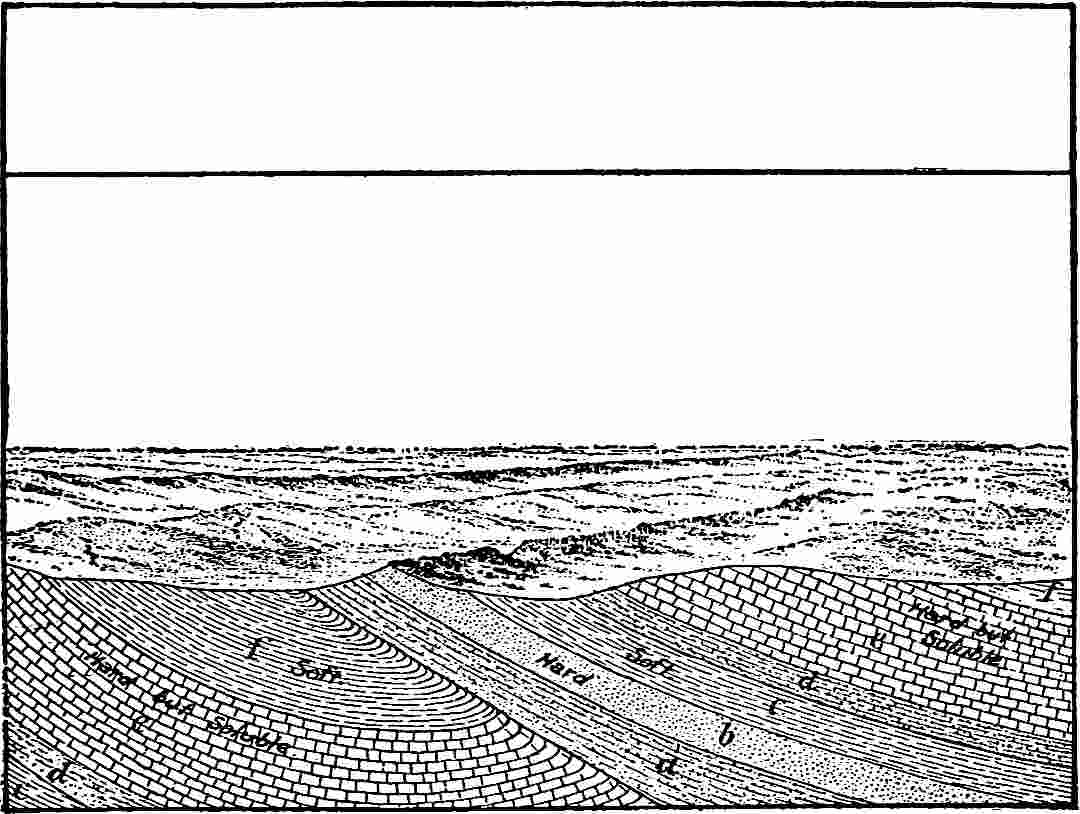
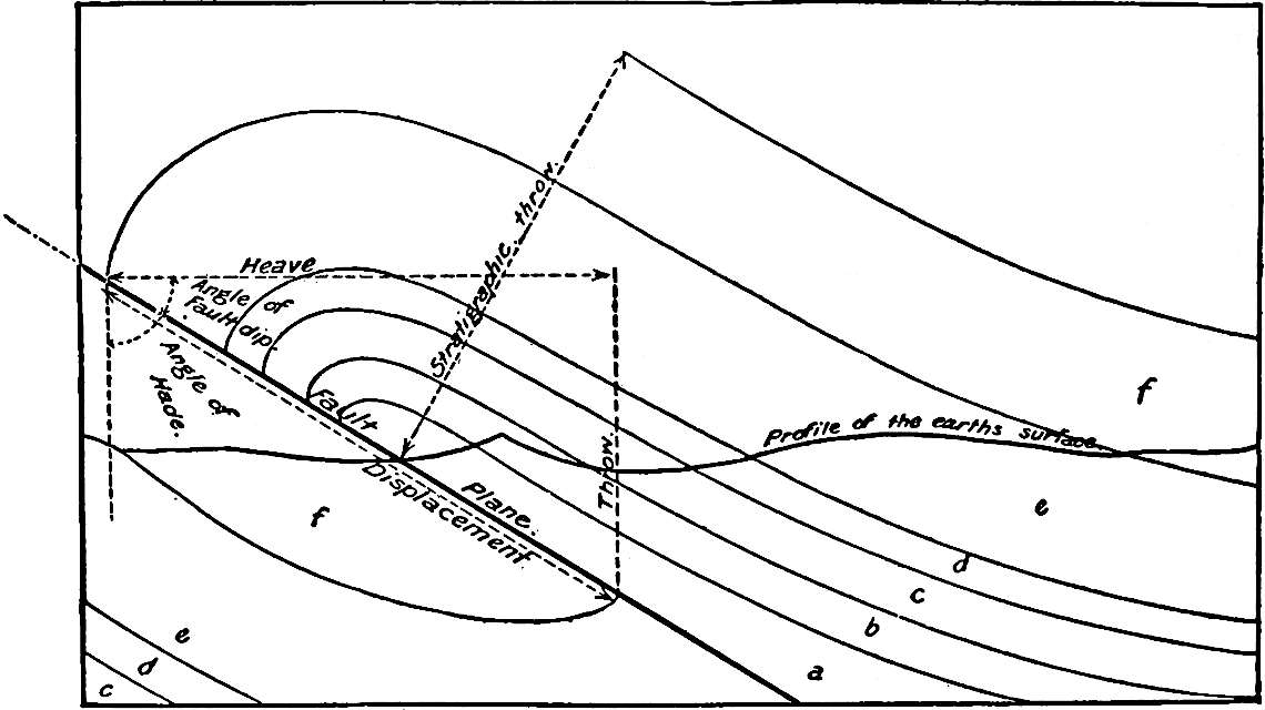
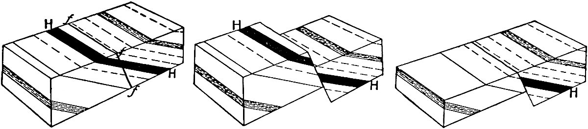
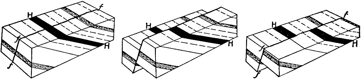
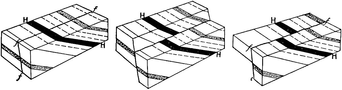
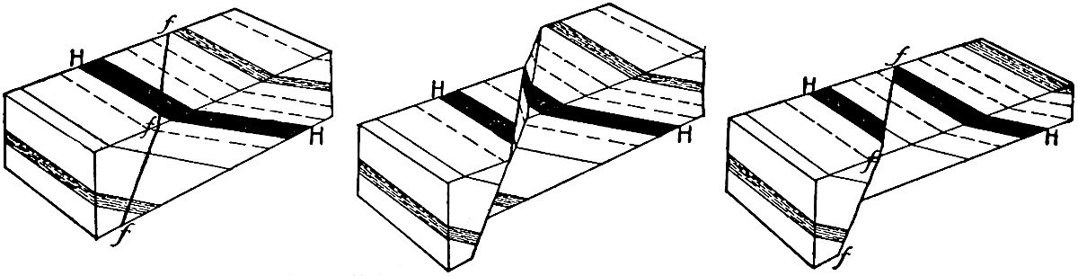
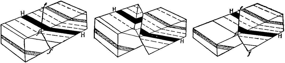
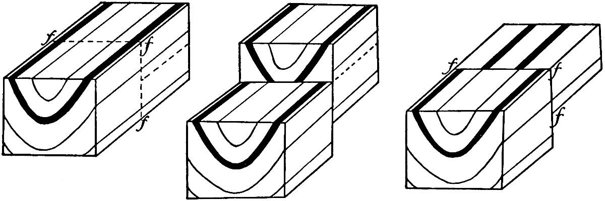
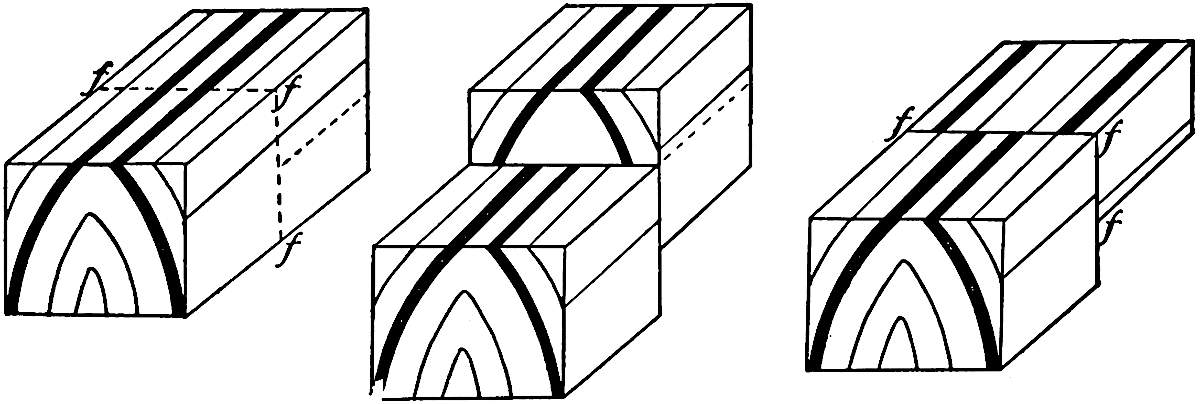
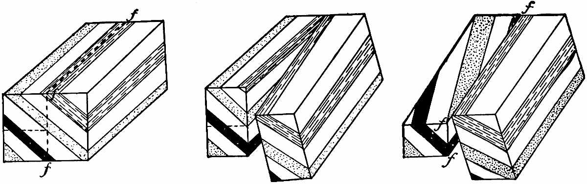
514. Faults, 514. The significance of faults, 521. Effect of faulting on outcrops, 522.
Points of origin, foci, 527. The amplitude of the vibrations, 529. Destructive effects,
530. Direction of throw, 531. Rate of propagation, 532. Sequences of vibrations, 533.
Gaseous emanations, 533. Distribution of earthquakes, 533.
Mountain-forming movements, 542. Distribution of folded ranges, 543. Plateau-forming
movements, 543. Continent-forming movements, 544. Relations of these movements in time, 545.
Relations of vertical to horizontal movements, 545. The squeezed segments, 546. The depressed
or master segments, 546. The differential extent of crustal movements, 548.
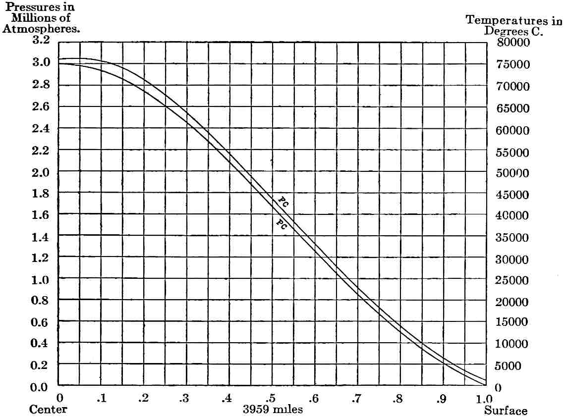
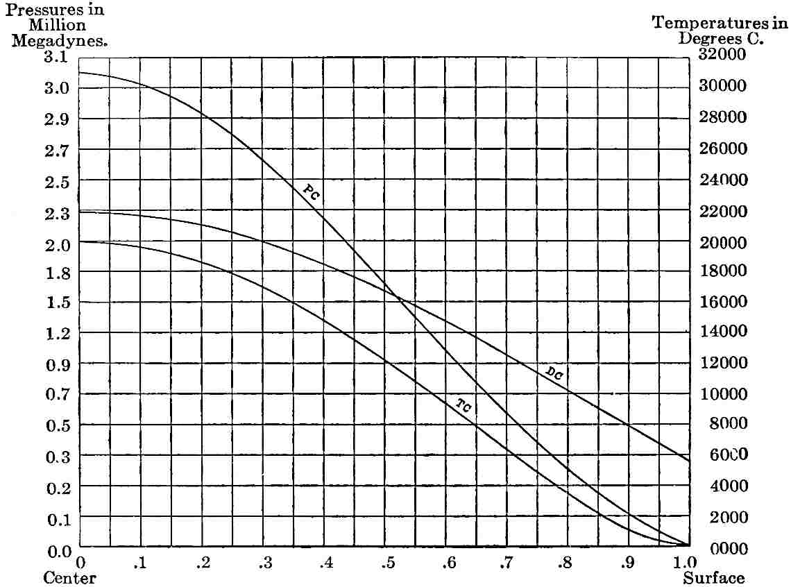
Thermal distribution on the convection hypothesis, 559. Level of no stress, 561.
Thermal distribution on the hypothesis of central solidification, 562. Thermal distribution under
the accretion hypothesis, 564.
xviComputed Pressures, Densities,
and Temperatures within theEarth Based on Laplace’s Law
Explanations of varying increment, 570. The permeation and circulation of water,
570. Chemical action, 570. Differences in the conductivity of rock, 571. Compression,
571. Gradients projected, 571. The amount of loss of heat, 572. The amount of shrinkage
from loss of heat, 572.
Transfer of internal heat, 574. Denser aggregation of matter, 574. Extravasation
of lavas, 574. Change in the rate of rotation, 575. Distribution of rigidity, 578.
The influence of the domed form of the surface, 581. Theoretical strength of domes
of earth-dimensions, 581. Stress-accumulation independent of sphericity, 583. The actual
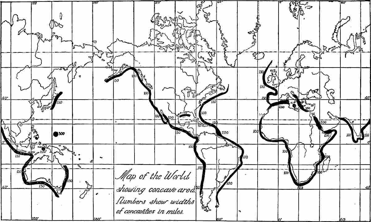
configuration of the surface, 584. Concave tracts, 584. General conclusion, 588.
Lavas assigned to the reaction of water and air penetrating to hot rocks, 625. Lavas
assigned to relief of pressure, 627. Lavas assigned to melting by crushing, 628. Lavas assigned
to melting by depression, 629. Vulcanism assigned to the outflow of deep-seated heat, 629.
The consumption and restoration of carbon dioxide, 640. The freezing and consumption of
oxygen, 640. The organic residue, 640. The meaning of the organic residue, 641. The more
inert factor, 642. Probable fluctuations xviiiof atmospheric
composition, 642. The climatic effects of organic action, 643.
(1) The material effects of the mental element, 649. Human modification of the animal and
vegetal kingdoms, 650. (2) The psychological factors as such, 651.
Reference table of the principal groups of plants, 653. The contribution of the Thallophytes,
653. The contribution of the Bryophytes, 656. The contribution of the Pteridophytes,
657. The contribution of the Spermatophytes, 657. Plant life terrestrial rather than marine, 658.
Reference table of the principal groups of animals, 659. The contribution of the Protozoa,
660. The contribution of the Cœlenterata, 661. The contribution of the Echinodermata, 661.
The contribution of the Vermes, 662. The contribution of the Molluscoidea, 662. The contribution of the
Mollusca, 662. The contribution of the Arthropoda, 662. The contribution of the Vertebrata, 663.
III. The Associations and Ecological Relations of Life
Geology treats of the structure of the earth, of the various
stages through which it has passed, and of the living beings that
have dwelt upon it, together with the agencies and processes involved
in the changes it has undergone. Geology is essentially a history
of the earth and its inhabitants. It is one of the broadest
of the sciences, and brings under consideration certain phases of
nearly all the other sciences, particularly those of astronomy,
physics, chemistry, zoology, and botany. It also embraces the earlier
expressions of mental development and of life-relationships, chiefly as
found in the lower animals.
Subdivisions.—Naturally so broad a science has many special
aspects which constitute subdivisions, in a sense, though they
are rather dominant phases than independent sections. That phase
which treats of the outer relations of the earth is Cosmic
or Astronomic geology; that which treats of the constituent
parts of the earth and its material is Geognosy, of which the
most important branch is Petrology, the science of rocks.
That branch which investigates the structural arrangement of the
material, or “the architecture of the earth,” is Geotectonic,
or Structural geology; while that which deals with the surface
changes and topographic forms, that is, with the face of the earth, is
Physiographic geology. The study of the fossils that have been
preserved in the rocks, and of the faunas and floras that these imply,
constitutes Paleontologic geology, or Paleontology. The
treatment of the succession of events forms Historical geology.
This is chiefly worked out by the succession of beds laid down in the
progress of the ages, which constitutes Stratigraphic geology.
The treatment of causes, agencies, and processes is the function of
Dynamic or Philosophic geology.
Besides these there are special applications which give occasion
for other terms, as Economic geology, which is concerned
with the industrial applications of geologic knowledge; Mining
geology, which2 is a sub-section of economic geology, relating to
the application of geologic facts and principles to mining operations;
Atmospheric geology, Glacial geology, and others that
define themselves, and are for the greater part but limited aspects of
the broad science.
Dominant processes.—Three sets of processes, now in operation on
the surface of the lithosphere, have given rise to most of the details
of its configuration, and even many of its larger features. These
processes have been designated diastrophism, vulcanism,
and gradation. Diastrophism includes all crustal
movements, whether slow or rapid, gentle or violent, slight or
extensive. Many parts of the land, especially along coasts, are known
to be slowly sinking relative to the sea-level, while other parts are
known to be rising. The fact that rocks originally formed beneath the
sea now exist at great elevations, and the further fact that areas
which were once land are now beneath the sea, are sufficient evidence
that similar changes have taken place in the past. Vulcanism
includes all processes connected with the extrusion of lava and other
volcanic products, and with the rise of lava from lower to higher
levels, even if not extruded. Vulcanism and diastrophism may be closely
associated, for local movements at least are often associated with
volcanic eruptions, and more considerable movements may be connected
with the movements of subsurface lavas, even when the connection
is not demonstrable. Gradation includes all those processes
which tend to bring the surface of the lithosphere to a common level.
Gradational processes belong to two categories—those which level down,
degradation, and those which level up, aggradation. The
transportation of material from the land, whether by rain, rivers,
glaciers, waves, or winds, is degradation and the deposition of
material, whether on the land or in the sea, is aggradation.
Degradation affects primarily the protuberances of the lithosphere,
while aggradation affects primarily its depressions.
Astronomic Geology.
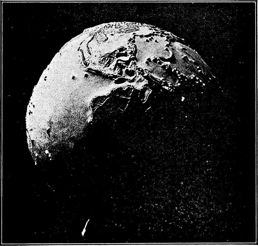
The earth as a planet.—Though supremely important to us, the
earth is but one of the minor planets attendant upon the sun, and is
in no very special way distinguished as a planetary body. Of the eight
planets, four, Jupiter, Saturn, Uranus, and Neptune, are much larger
than the earth, while three, Mars, Venus, and Mercury, are smaller.
There are a host of asteroids, but all together they do not equal the
mass of the smallest planet. The average mass of the eight planets3 is
more than fifty times that of the earth, while the largest, Jupiter,
is more than three hundred times as massive as the earth. The earth’s
position in the group is in no sense distinguished. It is neither
the outer nor the inner, nor even the middle planet. Even in the
minor group to which it belongs, it is neither the outermost nor the
innermost member, though in this group it is the largest. Its average
distance from the sun is about 92.9 million miles, and this fixes its
revolution at 365¼ days, for its period of revolution is directly
dependent on its distance from the sun, and is necessarily longer than
the revolutions of the inner planets and shorter than those of the
outer planets. Its rotation in twenty-four hours is not far different
from that of its neighbor Mars, but is much slower than the more
distant and larger planets, Jupiter and Saturn, which rotate in about
ten hours. Comparison cannot be made with the innermost and outermost
planets, because their rotations are not yet satisfactorily determined.
The plane of the earth’s revolution lies near the common plane of
the whole system, but this is not peculiar, as all of the planets
revolve in nearly the same plane. Only a few of the small asteroids
depart notably from this common plane. This has an important bearing
on theories of the origin of the system, since this close coincidence
of the planes of the orbits is not consistent with any haphazard
aggregation of the material. Of similar importance is the fact that
all of the planets revolve in the same direction and in ellipses that
do not depart widely from circles. The eccentricity of the earth’s
orbit is only about ¹⁄₆₀. This eccentricity varies somewhat, due to
the disturbing influences of the other planets, and this variation has
been regarded by some geologists as an influential cause of climatic
changes, but its adequacy to produce great effects has been doubted by
others. The inclination of the earth’s axis, now about 23½°, holds an
intermediate position, some of the planets having axes more inclined,
as Saturn, 26⅚°, and others less inclined, as Jupiter, 3°. The
inclination of the axis is subject to trivial variations at present,
and in the long periods of the past has possibly changed more notably.
This possible change has also been thought to be a cause of climatic
variation, but its efficiency has not been demonstrated.
Its satellite.—The earth is peculiar in having one unusually
large satellite, which has a mass ¹⁄₈₁ of its own. The great planets
have several satellites whose combined mass exceeds that of the moon,
and perhaps in some few cases the individual satellites may be larger
than the moon, but they do not sustain so large a ratio to their
planets,4 for Titan, probably the largest, is only ¹⁄₄₆₀₀ of the mass
of Saturn. There is little doubt that the moon has played an important
part in the history of the earth. It is the chief agency in developing
oceanic tides, and it possibly also develops a body tide in the earth
itself. These tides act as a brake on the rotation of the earth and
tend to reduce its rate, and thereby to lengthen the day. While this
may have been counteracted in some measure by the shrinkage of the
earth, which tends to increase its rate of rotation, it has been held
by eminent physicists and geologists that the rotation of the earth
has been greatly lessened during its history, and that a long train of
important consequences has resulted. If the contraction of the earth
has been sufficient to offset this lessening, the tidal brake must be
credited with the prevention of the excessive speed of rotation which
would otherwise have been developed. The tides are efficient agencies
in the shore wear of the oceans, and in the distribution of marine
sediments, and these, it will be seen later, are important elements in
the formation of strata.
Dependence on the sun.—By far the most important external
relation of the earth, however, is its dependence on the sun. The earth
is a mere satellite of the sun, less than ¹⁄₃₀₀₀₀₀ of its mass, and
hence under its full gravitative control. The earth is dependent on the
sun for nearly all its heat and light, and, through these, for nearly
all of the activities that have given character to its history. It is
too much to say that all activities on the surface of the earth are
solely dependent on those of the sun, for a certain measure of heat and
light and other energy is derived from other bodies, and a certain not
inconsiderable source of energy is found in the interior of the earth
itself; yet all of these are so far subordinate to that great flood of
energy which comes from the sun that they are quite inconsequential.
The history of the earth in the past has been intimately dependent upon
that of the sun, and its future is locked up with the destiny of that
great luminary. Geology in its broadest phases can therefore scarcely
be separated from the study of the sun, but this falls within the
function of the astronomer rather than the geologist.
Meteorites.—There are a multitude of small bodies passing
through space in varying directions and with varying velocities and
occasionally encountering the earth, to which they add their substance.
Some of these meteorites revolve about the sun much as if they were
minute planets, but some of them come from such directions and with
such velocities as to show that they do not belong to the solar family.
Some5 consist almost wholly of metal, chiefly iron alloyed with a
small percent. of nickel (holosiderites); some consist of metal and
rock intimately mixed (syssiderites and sporadosiderites); and some
consist wholly of rock (asiderites). The rock is usually composed of
the heavier basic minerals, though some meteorites consist largely
of carbonaceous material. Besides meteorites, there is little doubt
that wandering gaseous particles strike the earth, but this is beyond
the reach of present demonstration. The amount of substance added to
the earth by these meteorites and gases in recent times is relatively
slight compared with the whole body of the earth. What contribution may
have come to the earth in earlier times from such sources is a matter
of hypothesis which will be discussed later.
Geognosy.
The constitution of the earth.—Turning from its external
relations to the earth itself, a natural threefold division is
presented: (1) the atmosphere, (2) the hydrosphere, and (3) the
lithosphere.
I. The Atmosphere.
The atmosphere is an intimate mixture of (1) all those substances
that cannot take a liquid or solid state at the temperatures and
pressures which prevail at the earth’s surface, together with (2) such
transient vapors as the various substances of the earth throw off. The
first class form the permanent gases of the atmosphere, and consist
of nitrogen about 79 parts, oxygen about 21 parts, carbon dioxide
about .03 part, together with small quantities of argon, neon, xenon,
krypton, helium, and other rare constituents. The second class are
the transient and fluctuating constituents of the atmosphere, chief
among which is aqueous vapor, which varies greatly in amount according
to temperature, pressure, and other conditions. To this are to be
added volcanic emanations and a great variety of volatile organic
substances. Theoretically, every substance, however solid, discharges
particles which may transiently become constituents of the atmosphere.
Practically, only a few of these exist in such quantity as to be
appreciable. Dust and other suspended matter are usually regarded as
impurities rather than constituents of the atmosphere, but they play a
not unimportant part by affecting its temperature and luminosity, and
by facilitating the condensation of moisture.
6
Mass and extent.—The total mass of the atmosphere is estimated
at five quadrillion tons, or ¹⁄₁₂₀₀₀₀₀ of the mass of the earth. It is
relatively dense at the surface of the earth and decreases in density
outwards in a manner difficult of absolute determination, so that the
actual height of the appreciable atmosphere is not positively known.
The true conception of the atmosphere is perhaps that of a tenuous
envelope exerting a pressure of about fifteen pounds per square inch
at the sea-level, and thinning gradually upwards until it reaches a
tenuity which is inappreciable, but perhaps not ceasing absolutely
until the sphere of gravitative control of the earth is passed, about
620,000 miles from the lithosphere. In the lower portion, according to
the kinetic theory of gases, the molecules fly to and fro, colliding
with each other with almost inconceivable frequency, and with very
short paths between successive collisions, but in the upper rare
portion some of the molecules bound outwards, and do not strike other
molecules, and hence pursue long elliptical paths until the gravity of
the earth overcomes their momentum, when they return, perhaps to bound
off again or to force other molecules to do so. This fountain-like
nature of the outer part of the atmosphere makes any sharp definition
of its limit impracticable. Some molecules are believed to be shot away
at such speed that they do not return. Beyond about 620,000 miles from
the surface of the lithosphere, the differential attraction of the sun
is greater than that of the earth, and if the attraction of the earth
does not turn the molecules back before reaching this distance, they
are almost certain to be lost to the earth.
The measurement of heights by the aneroid barometer, which is much used
in practical geology, is dependent on the lessening of pressure as the
instrument is carried upward.
Geologic activity.—The atmosphere is the most mobile and active
of the three great subdivisions of the earth, and when its indirect
effects through the agency of water, as well as its direct effects,
are considered, it is to be regarded as one of the most effective
agencies of change. It acts chemically upon the rock substance of the
earth, causing induration in some instances, but more often inducing
disintegration and change of composition by means of which rock is
reduced to soil, or soil-like material, and rendered susceptible of
easy removal by winds and waters. When in motion the atmosphere acts
mechanically on the surface of the earth, transporting dust and sand,
and by the friction of these it abrades the surface. It is chiefly
effective, however, in furnishing the7 conditions for water action.
Partly by its mechanical aid, but chiefly by securing the right
temperature, it is a necessary factor in the action of rains, streams,
glaciers, and the various forms of moving water upon land. So also,
on the ocean, wave action is essentially dependent on the winds. In
the absence of atmospheric propulsion, wave action would be chiefly
confined to the tides and to occasional earthquake impulses, and would
lose nearly all its efficiency. Stream action and wave action, which
are the most declared of the geological agencies, are therefore to be
credited as much to the atmosphere as to the hydrosphere, since the
action is a joint one to which both envelopes are essential.
A thermal blanket.—A function of the atmosphere of supreme
importance is the thermal blanketing of the earth. In its absence the
heat of the sun would reach the surface with full intensity, and would
be radiated back from the surface almost as rapidly as received, and
only a transient heating would result. During the night an intensity
of cold would intervene scarcely less severe than the temperature of
space. In penetrating the atmosphere certain portions of the radiant
energy of the sun are absorbed. Of the remainder which reaches the
surface of the earth, a part is transformed into vibrations of lower
intensity, which are then more effectively retained by the atmosphere.
The air thus distributes and equalizes the temperature. The two
constituents of the atmosphere which are most efficient in this work
are aqueous vapor and carbon dioxide, and the climate of the earth is
believed to have been very greatly affected by the varying amounts of
these constituents in the atmosphere, as well as by the total mass of
the atmosphere.
The function of the atmosphere in sustaining life and promoting all
that depends on life is too obvious to need comment.
The special geological action of the atmosphere will be discussed in
the next chapter.
II. The Hydrosphere.
About 1300 quadrillion tons of water lie upon the surface of the solid
earth. This equals about ¹⁄₄₅₄₀ part of the earth’s mass. Were the
surface of the solid earth perfectly spheroidal, this would constitute
a universal ocean somewhat less than two miles deep. Owing to the
inequalities of the rock surface, the water is chiefly gathered into a
series of great basins or troughs occupying about three-fourths (72%)8
of the earth’s surface. These basins are all connected with each other
and act as a unit, so that anything which changes the level of the
water in one changes the level of all. This helps to make a common
record of all great movements of the earth’s body, for the level of
the ocean determines where the detritus from the land shall lodge, and
hence where the edge of the marine beds shall be formed. This will
appear more clearly when the formation of marine strata is discussed.
Oceanic dimensions.—The surface area of the ocean is estimated
by Murray at 143,259,300 square miles. Of this, somewhat more than
10,000,000 square miles lie on the continental shelf, i.e., lap up on
the borders of the continental platforms. This shows that the great
basins are somewhat more than full. If about 600 feet of the upper
part of the ocean were removed, the true ocean basins would be just
full, and the surfaces of the true continental platforms would be dry
land. The area of the true oceanic basins is about 133,000,000 square
miles, and that of the true continental platforms about 64,000,000
square miles. Under about 20% of the ocean area, the bottom sinks
to depths between 6000 and 12,000 feet; under about 53% it sinks to
depths between 12,000 and 18,000 feet; and under the remaining 4%
it ranges from 18,000 feet down to about 30,000. The last includes
those singular sunken areas known as “deeps,” and sometimes called
anti-plateaus, as they extend downward from the general ocean
bottom much as the plateaus protrude upwards from the general land
surface.
Besides the ocean, the hydrosphere includes all the water which
constitutes the surface streams and lakes, together with that which
permeates the pores and fissures of the outer part of the solid earth;
but altogether these are small in amount compared with the great ocean
mass.
Geologic activity.—Of all geological agencies water is the
most obvious and apparently the greatest, though its efficiency is
conditioned upon the presence of the atmosphere, upon the relief of
the land, and upon the radiant energy of the sun. Through the agency
of rainfall, of surface streams, of underground waters, and of wave
action, the hydrosphere is constantly modifying the surface of the
lithosphere, while at the same time it is bearing into the various
basins the wash of the land and depositing it in stratified beds. It
thereby becomes the great agency for the degradation of the land and
the building up of the basin bottoms. It works upon the land partly
by dissolving soluble portions of the rock substance, and partly by
mechanical action. The9 solution of the soluble part usually loosens
the insoluble, and renders it an easy prey of the surface waters.
These transport the loosened material to the valleys and at length to
the great basins, meanwhile rolling and grinding it and thus reducing
it to rounder forms and a finer state, until at length it reaches the
still waters or the low gradients of the basins and comes to rest.
The hydrosphere is therefore both destructive and constructive in its
action. As the beds of sediment which it lays down follow one another
in orderly succession, each later one lying above each earlier one,
they form a time record. And as relics of the life of each age become
more or less imbedded in these sediments, they furnish the means of
following the history of life from age to age. The historical record
of geology is therefore very largely dependent upon the fact that the
waters have thus buried in systematic order the successive life of the
ages. Aside from this, the means of determining the order of events of
the earth’s history are limited and more or less uncertain.
The special processes of the hydrosphere in its various phases will
be the subject of discussion hereafter (Chaps. III, IV, VI). Suffice
it here to recognize its great function in the constant degradation
of the land, and in the deposition of the derived material in orderly
succession in the basins.
Chief horizons of activity.—The great horizons of geological
activity are (1) the contact zone between the atmosphere and the
hydrosphere, chiefly the surface of the ocean, (2) the contact zone
between the hydrosphere and the lithosphere, chiefly the shore belts,
and (3) the contact zone of the atmosphere and surface waters, with the
face of the continents. It is in these three zones that the greatest
external work is being done and has been done in all the known ages.
III. The Lithosphere.
The atmosphere and hydrosphere are rather envelopes or shells than true
spheres, though in some degree both penetrate the lithosphere. The
lithosphere, on the other hand, is a nearly perfect oblate spheroid
with a polar diameter of 7899.7 miles, and an equatorial diameter of
about 26.8 miles more. Its equatorial circumference is 24,902 miles,
its meridional circumference 24,860 miles, its surface area 196,940,700
square miles, its volume 260,000,000,000 cubic miles, and its average
specific gravity about 5.57. The oblateness of the spheroid is an
accommodation to the rotation of the earth, the centrifugal force
at the10 equator being sufficient to cause the specified amount of
bulging there. Computations seem to indicate that the accommodation
is very nearly what would take place if the earth were in a liquid
condition, from which the inference has been drawn that it must have
been in that condition when it assumed this form, and must have
continued essentially liquid until it attained its present rate of
rotation, since, if the earth once rotated at a much higher speed, the
flattening at the poles and the bulging at the equator must have been
correspondingly greater. It is thought by others, however, that the
plasticity of the earth is such that it would at all times assume a
close degree of approximation to the demands of rotation, even if the
interior were in a solid condition. By still others it is thought that
the contraction of the earth has tended to accelerate the rotation
about as much as the tides have tended to retard it, and that it has
undergone little change of form.
Irregularities.—It is only in a general view, however, that
there is a close approximation to a perfect spheroidal surface. In
detail there are very notable variations from it. Geodetic surveys seem
to have shown that the equatorial diameters are not all equal, even
when the measurements are reduced to sea-level, but research along
this line has not reached a sufficient stage of completeness to permit
satisfactory discussion. It is, however, highly probable that the
ocean surface as well as the average land surface is warped out of the
perfect spheroidal form to some notable degree. This is very likely due
to inequalities in the density of the earth’s interior. The fact that
the larger portion of the water is gathered on one side of the globe,
while the land chiefly protrudes on the opposite side, is very possibly
due to unequal specific gravity in the interior of the earth.
The most obvious departure from a spheroidal form is found in the
protrusion of the continents and in the sinking away of the earth
surface under the oceans. As these inequalities present themselves
to-day, they are known as continental platforms and ocean basins. These
do not correspond accurately with the present land and water surfaces.
About the continental lands there is a submerged border extending some
distance out from the shore, and constituting a sea-shelf beyond which
the surface descends rapidly to the great depths of the ocean. This
slightly submerged portion, known as the continental shelf, belongs
as properly to the continent as the adjacent low lands which are not
submerged. The submergence of the edge of this shelf at present is
usually about 100 fathoms, so that if the upper 600 feet 11of the
ocean were removed, the outlines of the land would correspond quite
closely with the border of the true continental platform.
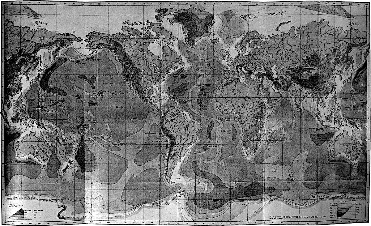
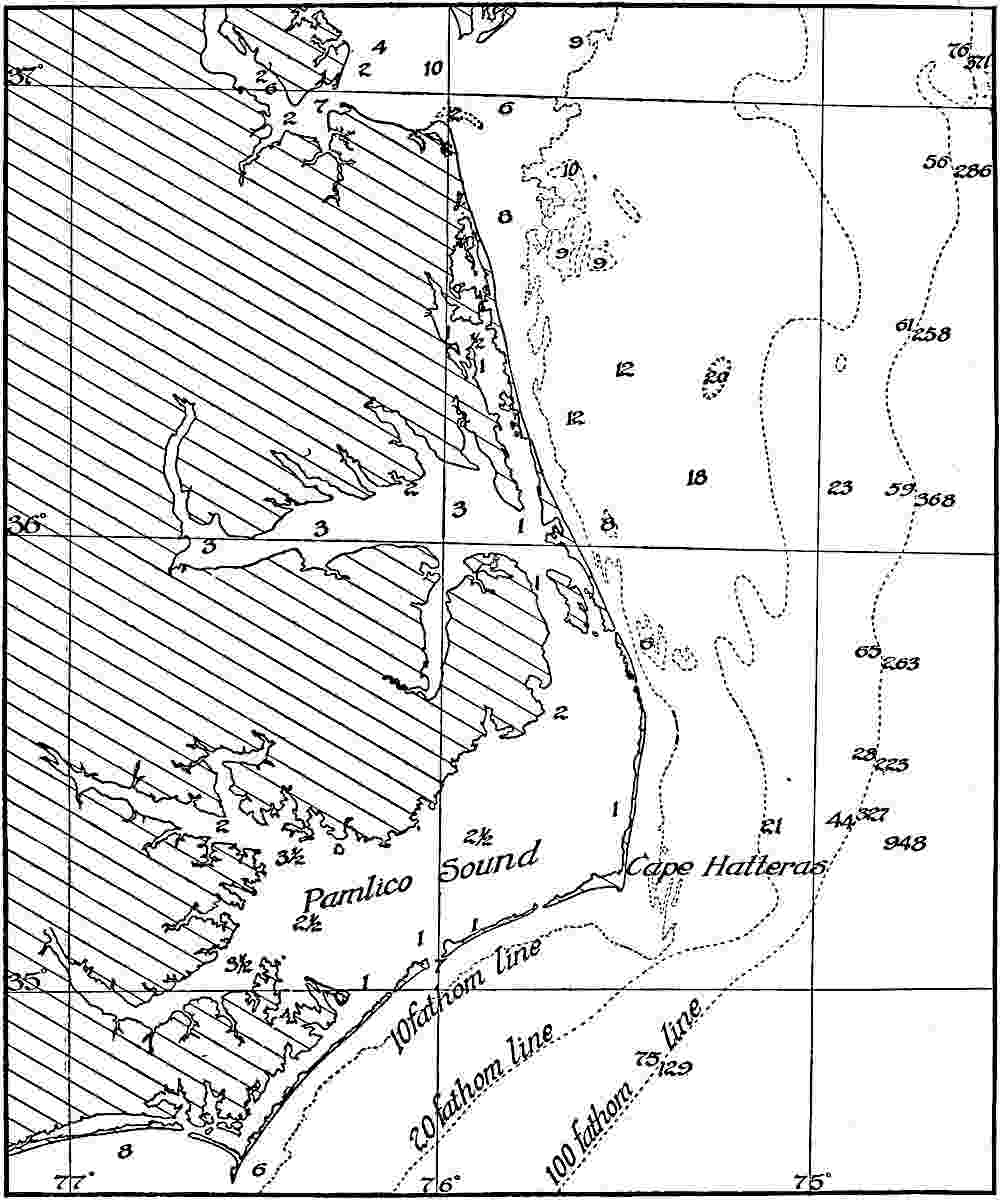
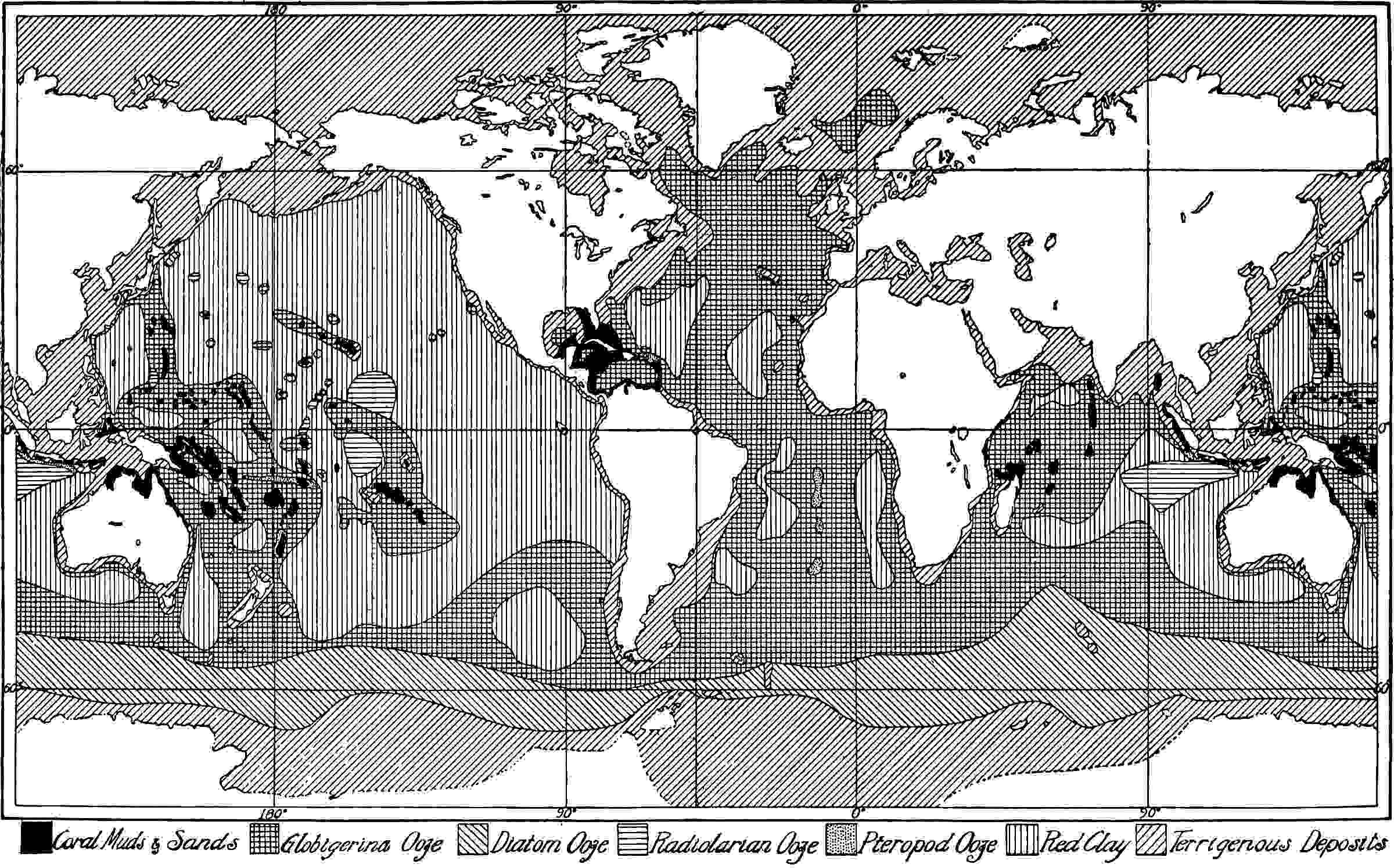
BATHYMETRICAL CHART OF THE OCEANS SHOWING THE “DEEPS” ACCORDING TO SIR JOHN MURRAY
It is customary to look upon the protrusions of the continents as the
great features of the earth’s surface, but in reality the oceanic
depressions are the master phenomena. In breadth, depth, and capacity
they much exceed the continental protrusions, and if the earth be
regarded as a shrunken body, the settling of the ocean bottoms has
doubtless constituted its greatest surface movement. From the estimates
of Murray, Gilbert has derived the following tables, showing the
relative areas of the lithosphere above, below, and between certain
levels.[1]
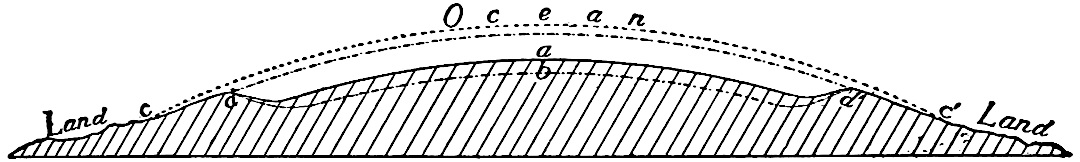
From these estimates it appears that if the surface were graded to a
common level by cutting away the continental platforms and dumping the
matter in the abysmal basins, the average plane would lie somewhere
near 9000 feet below the sea-level. The continental platform may
be conceived as rising from this common plane rather than from the
sea-level.
Contours.
Percent. of Surface above.
Percent. of Surface below.
Contour 24,000 feet above sea-level
0.004
99.996
“18,000 “
““
0.09
99.91
“12,000 “
““
0.7
99.3
“
6,000 “
““
2.3
97.7
Sea level
27.7
72.3
Contour 6,000 feet below sea-level
42.5
57.5
“
12,000 “
““
57.3
42.7
“
18,000 “
““
96.8
3.2
“
24,000 “
““
99.93
0.07
Percent.
More than 6000 feet above sea-level
2.3
Between sea-level and 6000 feet above
25.5
Between sea-level and 6000 feet below
14.8
Between 6000 and 12,000 feet below sea-level
14.8
Between 12,000 and 18,000 feet below sea-level
39.4
Between 18,000 feet and 24,000 feet
3.1
Epicontinental seas.—Those shallow portions of the sea which lie
upon the continental shelf, and those portions which extend into the
interior of the continent with like shallow depths, such as the Baltic
12Sea and the Hudson Bay, may be called epicontinental seas, for they
really lie upon the continent, or at least upon the continental
platform; while those other detached bodies of water which occupy deep
depressions in the surface are to be regarded as true abysmal seas,
as, for example, the Mediterranean and Caribbean seas and the Gulf of
Mexico, whose bottoms are as profound as many parts of the true ocean
basin itself.
Diversities of surface.—The bottoms of the oceanic basins are
diversified by broad undulations which range through many thousands
of feet, but they are not carved into the diversified forms that give
variety to land surfaces. The ocean bottoms are also diversified by
volcanic peaks, many of which rise to the surface and constitute
isolated islands. Some of them have notable platforms at or near the
surface, cut by the waves or built up by the accumulation of sediment
and of coralline and other growths about them. Aside from these
encircling platforms, the solid surface usually shelves rapidly down to
abysmal depths, so that the islands constitute peaks whose heights and
slopes would seem extraordinary if the ocean were removed.
The surface of the land is diversified in a similar way by broad
undulations and volcanic peaks, and also by narrower wrinklings and
foldings of the crust; but all of these irregularities have been carved
into diversified and picturesque forms by subaërial erosion. In this
respect the surface of the land differs radically from the bed of the
sea. The agencies which have produced the continental platforms and
abysmal basins, and the great undulations and foldings, as well as the
volcanic extrusions that mark them, are yet subjects of debate. Here
lie some of the most difficult problems of geology, but these cannot be
stated with sufficient brevity to find a place here.
The surface mantle of the lithosphere.—The surface of the
lithosphere is very generally mantled by a layer of loose material
composed of soil, clay, sand, gravel, and broken rock. This loose
material is sometimes known as mantle rock, and sometimes as
rock waste. On the land, mantle rock is often composed of the
disintegrated products of underlying rock formations. It represents the
results of the recent action of the atmosphere, of water, of changes of
temperature, and of other physical agencies acting on the outer part of
the rock sphere. The surface of this mantle is being constantly removed
by wind and water, but as constantly renewed by continued decomposition
of the rock below. In some areas, especially in the northern part13 of
North America and the northwestern part of Europe, the soil graduates
down into an irregular sheet of mixed clay, sand, gravel, and bowlders,
known as drift. From this and other evidence it is inferred that
at a time not greatly antedating our own, ice, chiefly in the form of
glaciers, spread extensively over the high latitudes of the northern
hemisphere. In some parts of the earth the surface is still covered by
fields of snow and ice, comparable to those which formed the drift. In
still other places, especially along the flood plains of streams, the
mantle rock consists of deposits made by streams which were unable to
carry their loads of sediment to the sea.
The crust of the lithosphere.—Much of the detritus washed down
from the land finds its way to bodies of standing water, and beneath
lakes and seas the mantle of loose material is made up largely of the
gravel, sand, and mud derived from the land. Before deposition these
materials are more or less assorted and arranged in layers by waves
and currents. When consolidated they constitute rock. The weathering
of the rocks of the land, the wearing away of the resulting detritus,
and its deposition beneath standing water, are among the most important
processes of geologic change.
On the land, the mantle of loose material is sometimes absent, and
in such places the surface of solid rock of the crust appears. Bare
surfaces of rock are most commonly seen where the topography is rough,
especially on the slopes of steep-sided valleys and mountains, and on
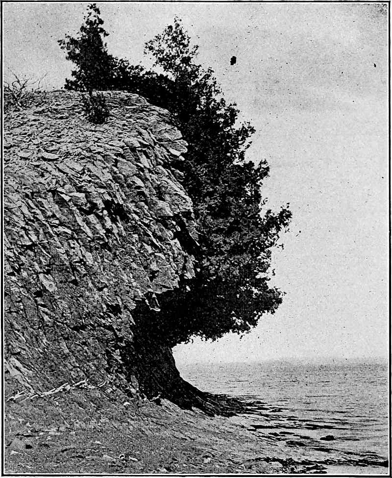
the slopes of cliffs which face seas or lakes. Solid rock, without
covering of soil or loose material of any sort, is also frequently seen
in the channels of streams, especially where there are falls or rapids.
We have but to note the effects of a vigorous shower on a steep slope,
or of a swift stream on its channel, or of waves on the cliffs which
face lakes and seas, to understand at least one of the reasons why
loose materials are frequently absent from steep slopes. The very
general exposure of solid rock where conditions favor surface erosion
suggests that rock is everywhere present beneath the soil or subsoil.
Fortunately there is an easy way of testing the universality of the
crust beneath the mantle. In all lands inhabited by civilized peoples
there are numerous wells and other excavations ranging from a few feet
to several hundred feet in depth, and occasional wells and mine-shafts
reach depths of several thousand feet. Even in shallow excavations
rock is often encountered, and in most regions excavations as much as
two or three hundred feet deep usually reach rock, and no really deep
boring14 has ever failed to find it. It may, therefore, be accepted as a
fact that the upper surface of the solid rock is nowhere far below the
surface.
Concerning the thickness of the crust, if there be any true crust
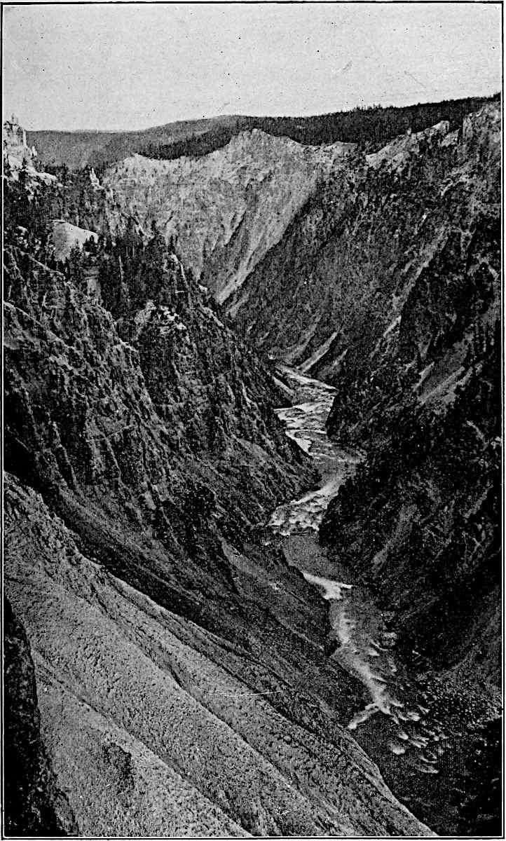
at all, little is known by direct observation. The deepest valleys,
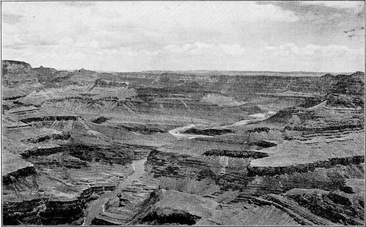
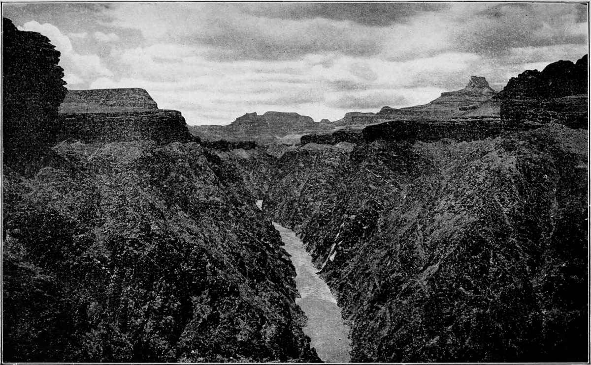
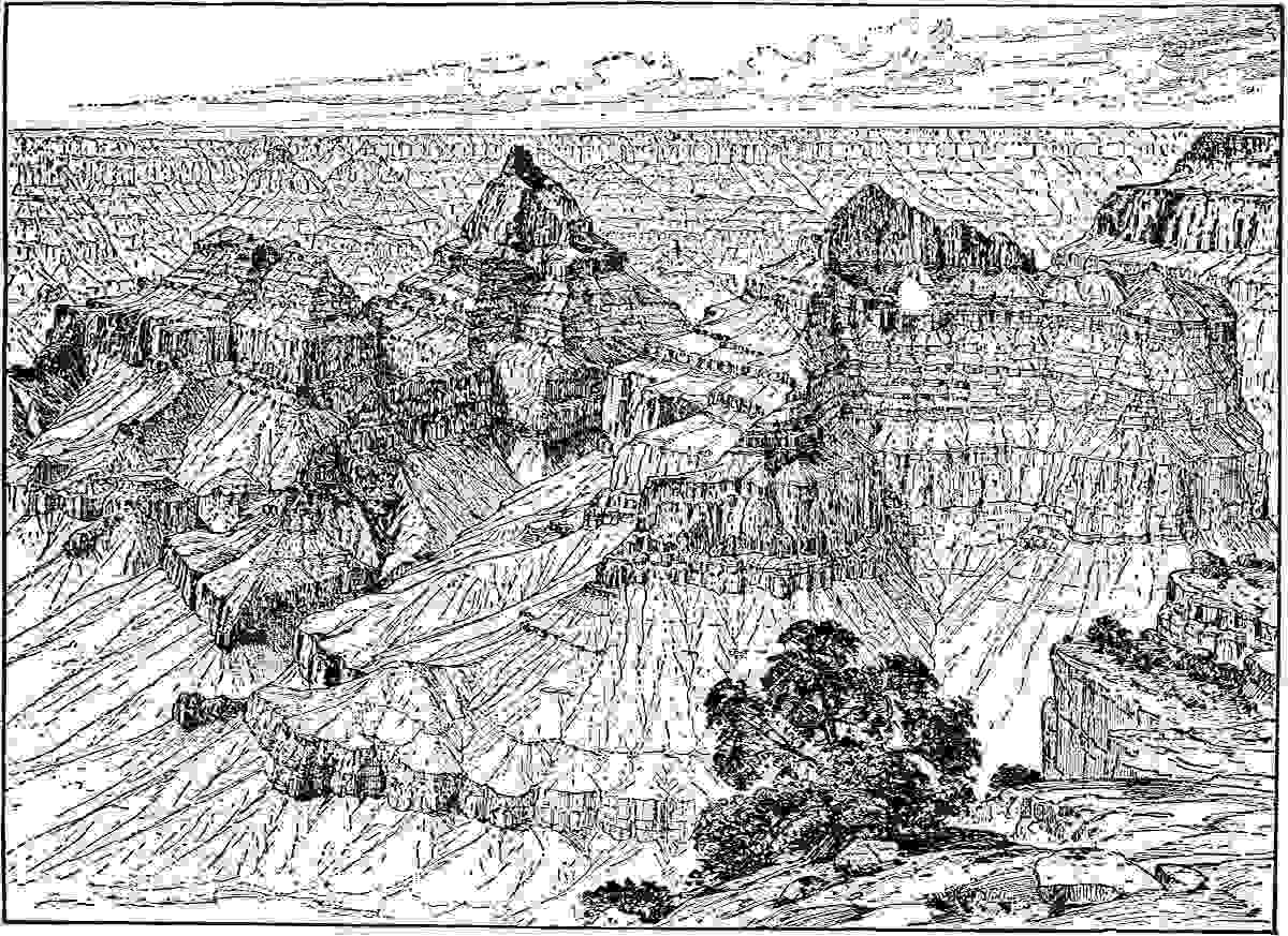
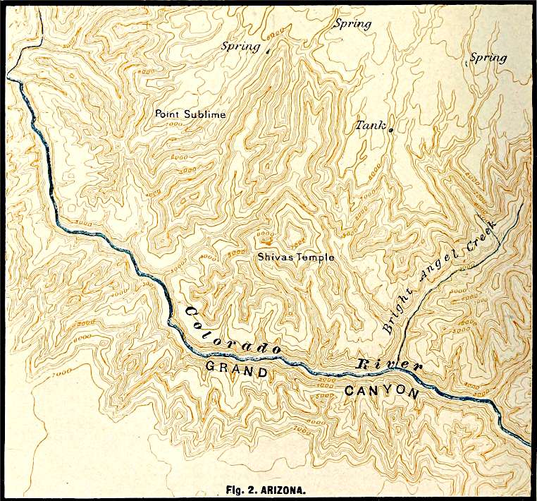
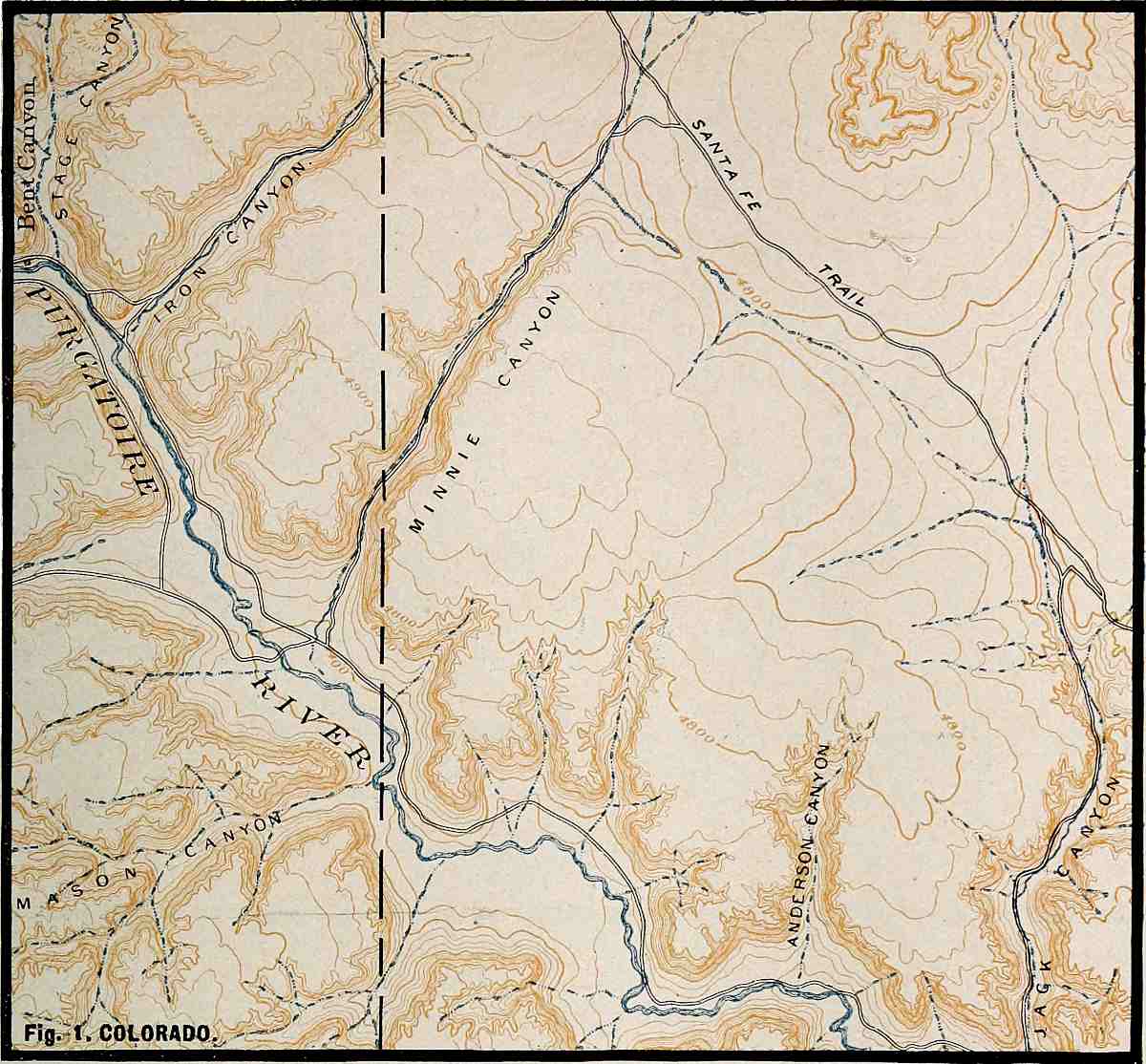
such as the canyon of the Colorado, and the shafts and borings of
the deepest mines and wells, give knowledge of nothing but rock. The
deepest excavations extend rarely more than a mile below the surface.
It is certain that rock of known kinds extends to far greater depths.
The interior.—Concerning the great interior of the earth, little
is known except by inference. From the weight of the earth,[2] it is
inferred that its interior is much more dense than its surface. From
its behavior under the attraction of other bodies, it is believed to
be at least as rigid as steel, and its interior cannot, therefore,
be liquid, in the usual sense of that term. From the phenomena of
volcanoes, and from observations on temperature in deep borings, it is
inferred that its interior is very hot. Further inferences concerning
its character are less simply stated, and will be referred to later.
The solid part of the earth is therefore composed of (1) a thin layer
of unconsolidated or earthy material, a few feet to a few hundred feet
in thickness, covering (2) a layer or zone many thousands of feet, and
probably many miles, thick, composed of solid rock comparable to that
exposed at numerous points on the surface, and (3) a central mass, to
which the preceding layers are but a shell, composed of hot, dense, and
rigid rock, the real nature of which is not known by observation.
Varieties of rock in crust.—If the mantle of soil, subsoil, and
glacial rubbish were stripped from the land, the surface beneath would
be found to be made up of a great variety of rocks, all of which may be
grouped into two great classes. About four-fifths of the land surface
would be of rock arranged in layers, and the other fifth would be of
crystalline rock, generally without distinct stratification, and often
bearing evidence of the effects of high temperature.
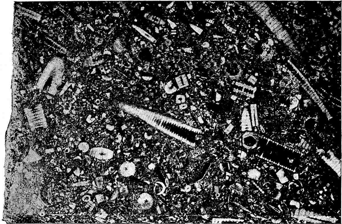
Stratified rocks.—The composition of most stratified rocks
corresponds somewhat closely with the composition of sediments now
being carried from the land and being deposited in the sea. Their
arrangement in layers is the same, and the markings on the surfaces
of the layers, such as ripple-marks, rill-marks, wave-marks, etc.,
are identical. Furthermore, the stratified rocks of the land, like
the recent sediments 15of the sea, frequently contain the shells and
skeletons of animals, and sometimes the impressions of plants. Most of
the relics of life found in the stratified rocks belonged to animals
or plants which lived in salt water. Because of their structure, their
composition, their distinctive markings, and the remains of life which
they contain, it is confidently inferred that most of the stratified
rocks which lie beneath the mantle rock of the land were originally
laid down in beds beneath the sea, and that the familiar processes of
the present time furnish the key to their history.
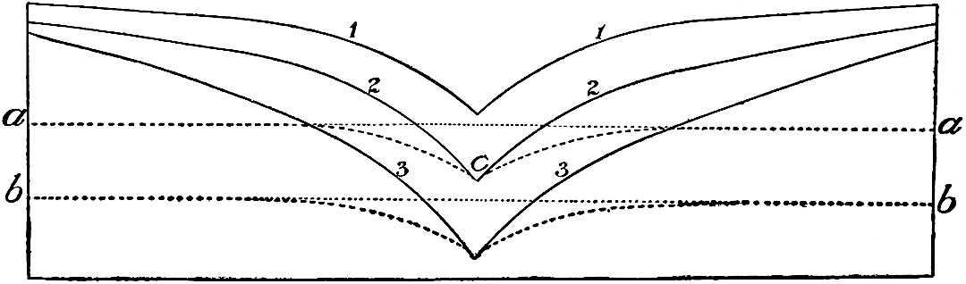
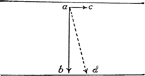
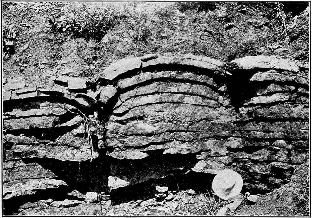
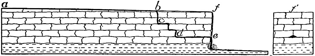
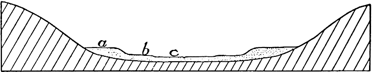
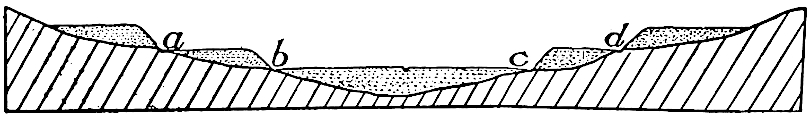
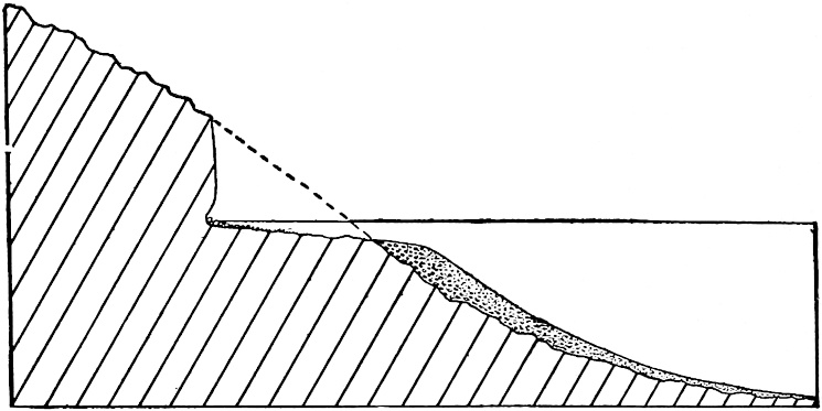
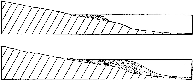
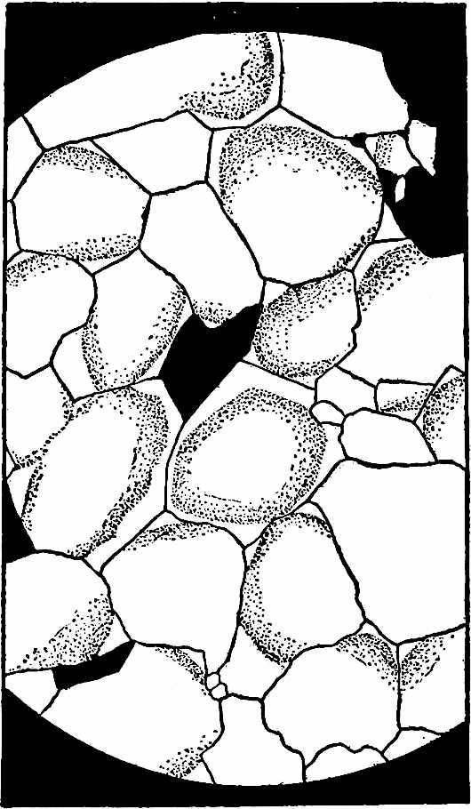
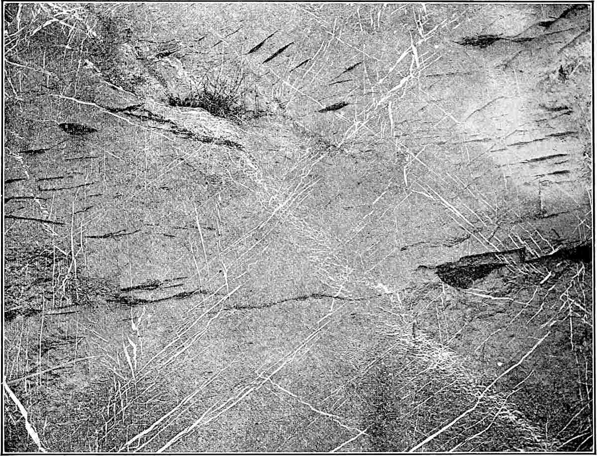
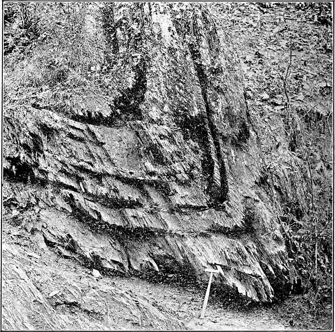
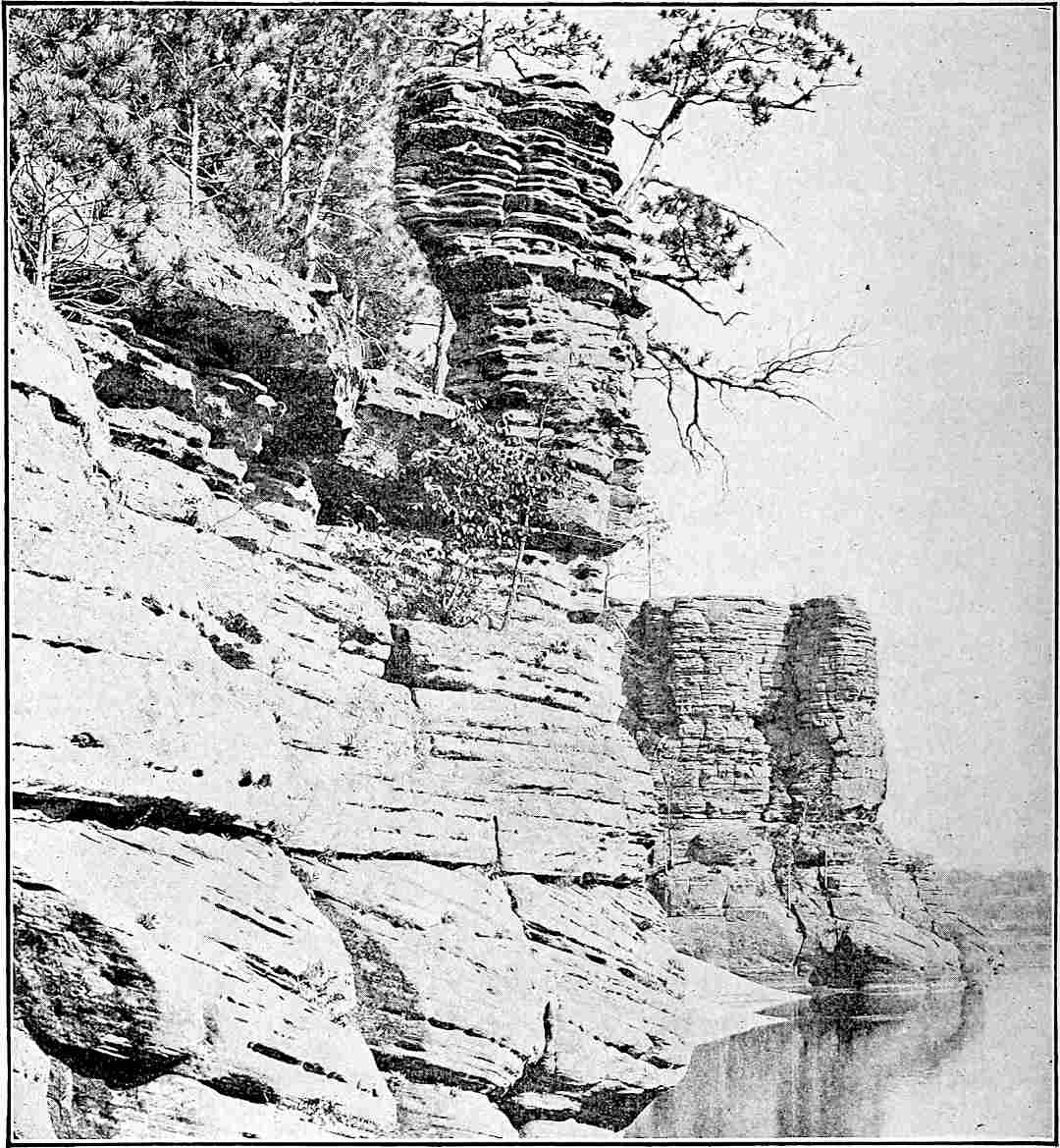
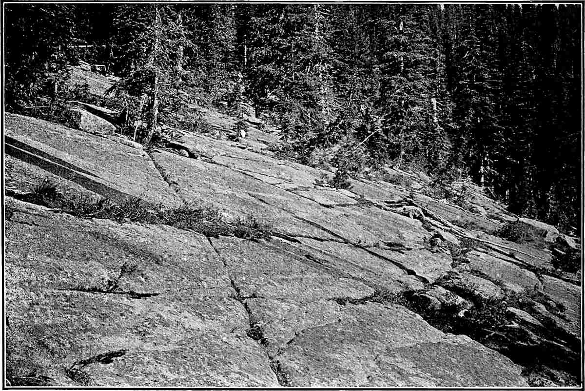
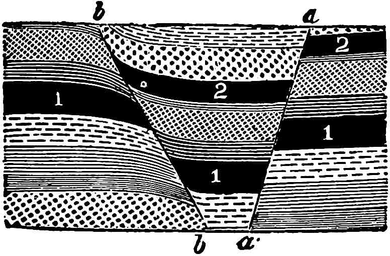
Fig. 1.—Beds of (Cambrian) sandstone, a,
are conformable with one another, but unconformable on beds of
(Huronian) quartzite, b, Near Ableman, Wis.
Conformability.—When the stratified rocks exposed by the removal
of the mantle rock are examined, the successive beds are sometimes
found to lie on one another in regular succession, showing that they
were laid down one after another, without change in the attitude of the
surface on which they were deposited. Such rocks are conformable
(the beds of series a, Fig. 1). In other cases it would be
seen that certain beds overlie the worn surfaces of lower beds, the
layers of which may have a different angle of inclination (series
a, Fig. 1, is unconformable on series b). Such relations
show that the lower series of beds was disturbed and eroded before
the overlying beds were deposited on them. Such series of rocks are
unconformable.
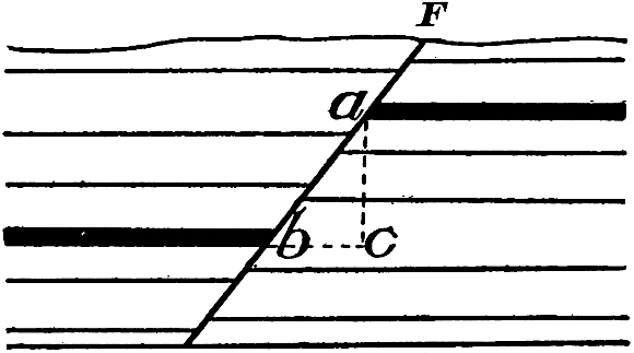
Relative ages.—The structure and relations of rocks lead to
inferences as to their relative ages. In the case of stratified
rocks it is obvious that overlying beds were deposited later than
those below, and where there is unconformity it is evident that an
interval of time elapsed between the deposition of the unconformable
series. Another and in some respects more important means of telling
their order of16 formation is found in the remains of life entrapped
in the water-laid sediments. Whatever life existed in the waters
in which the sediments were deposited was liable to burial, and if
it was possessed of hard parts, such as bones, teeth, shells, hard
integuments, etc., these parts, or at least their impressions, were
likely to be preserved in the sediments. Even tracks and imprints of
perishable parts are sometimes preserved. All these relics, which
we call fossils, give indications of the kinds of life which
existed when the beds were formed. The fossils of the youngest beds
show that the life which existed when they were deposited was quite
like that of the present time. The fossils of the next older and lower
beds show greater departure from present types. This series of changes
continues downward as lower and lower beds are studied, until beds at
considerable depths contain no relics of existing species but, in lieu
thereof, forms of more primitive types. Some of these earlier types are
clearly the ancestors of more modern forms, while others seem to have
no living descendants. Going still deeper, the fossils indicate life of
more and more primitive types, until they depart very widely from the
living forms, and seem to be but remotely ancestral. So the beds may be
followed downward until the lowest, which contain distinct evidences of
life, are reached.
It should be understood that it is not possible to proceed directly
downward through the whole succession of bedded rocks, but that the
edges of the various beds may be found here and there where they have
been brought to the surface by warpings or tiltings, or exposed by
the wearing away of the beds which once overlay them. The full series
of strata is made out only by putting together the data gathered
throughout all lands, and even when this is done an absolutely complete
series cannot yet be made out or, at least, has not been.
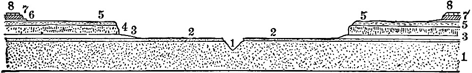
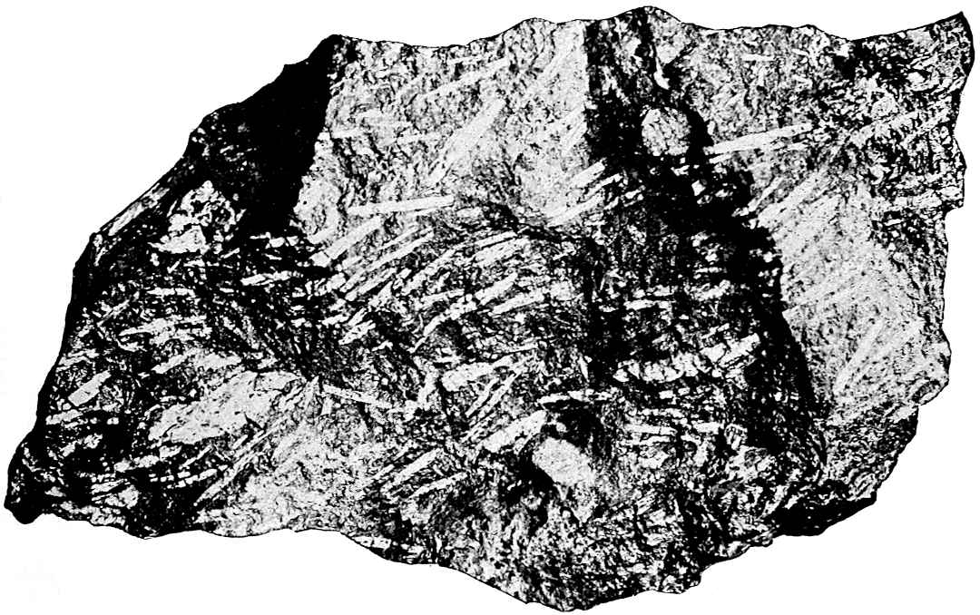
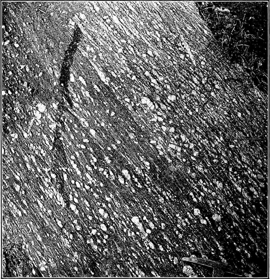
The crystalline rocks.—The crystalline rocks which would appear
if the mantle rock were removed are of two types, igneous and
metamorphic. Igneous rocks may be loosely defined as hardened
lavas. Metamorphic rocks are those which are greatly changed from their
original condition. Either stratified or igneous rocks may become
metamorphic.
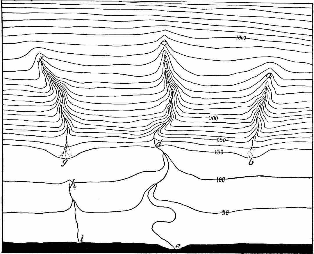
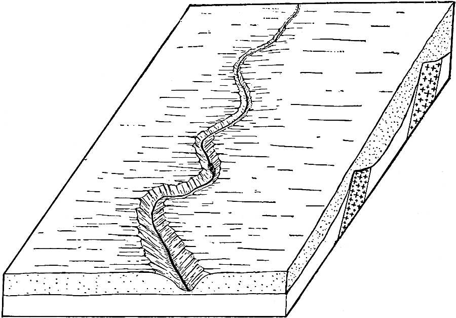
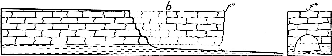
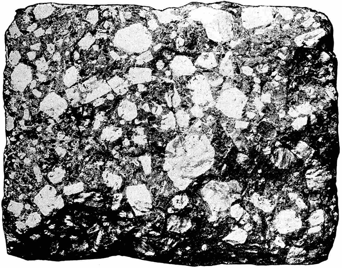
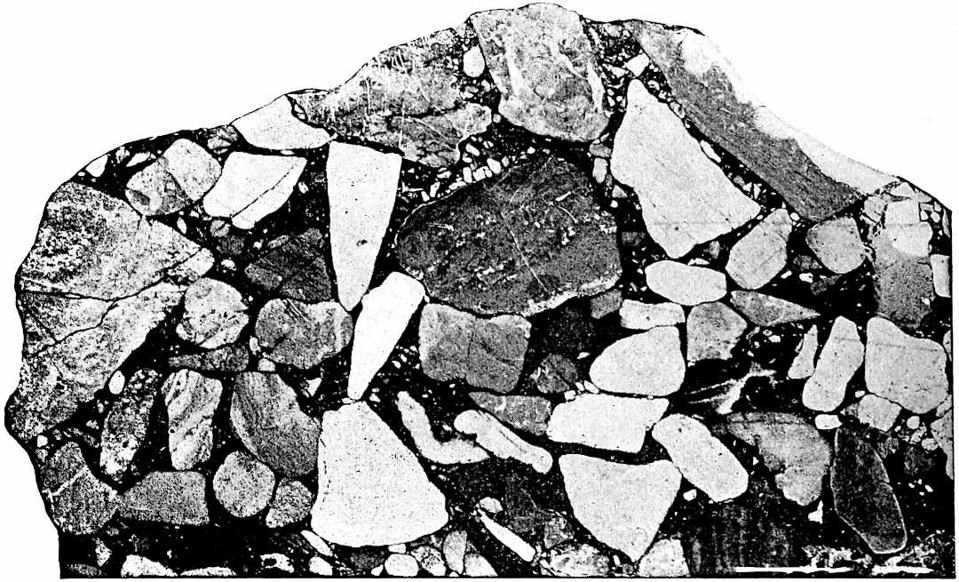
Igneous rocks sustain various relations to the stratified rocks, as
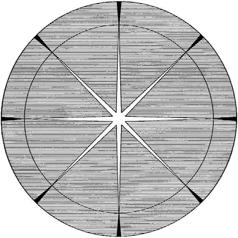
illustrated by Fig. 2. From these relations it is possible to tell
something of the order of their formation. Where the stratified rocks
are broken through by lavas, it is obvious that the stratified rocks
were formed first, and the lavas intruded later. Lava sheets intruded17
between beds of stratified rock can be told from those which flowed out
on the surface and were subsequently buried, for in the former case the
sedimentary rocks, both above and below the igneous rock, were affected
by the heat, while in the latter case only those below were so affected.
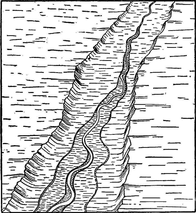
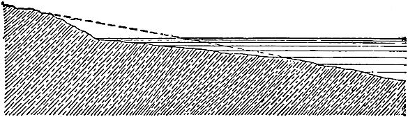
Fig. 2.—Diagrammatic representation of the
relations of igneous rock to stratified rock. The igneous rocks,
represented in black, have been forced up from beneath.
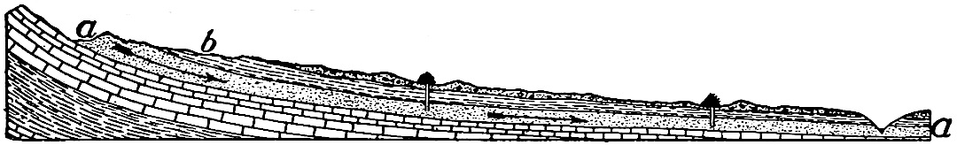
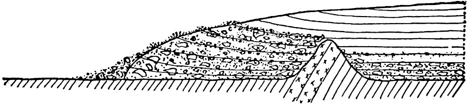
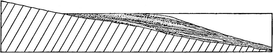
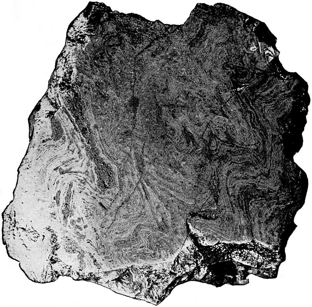
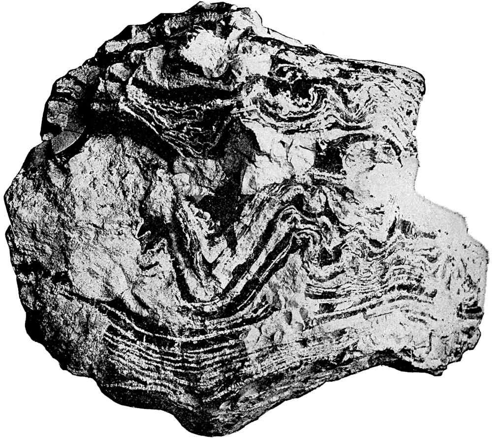
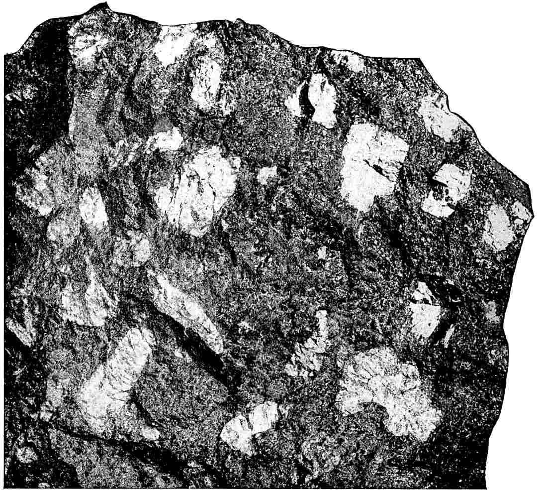
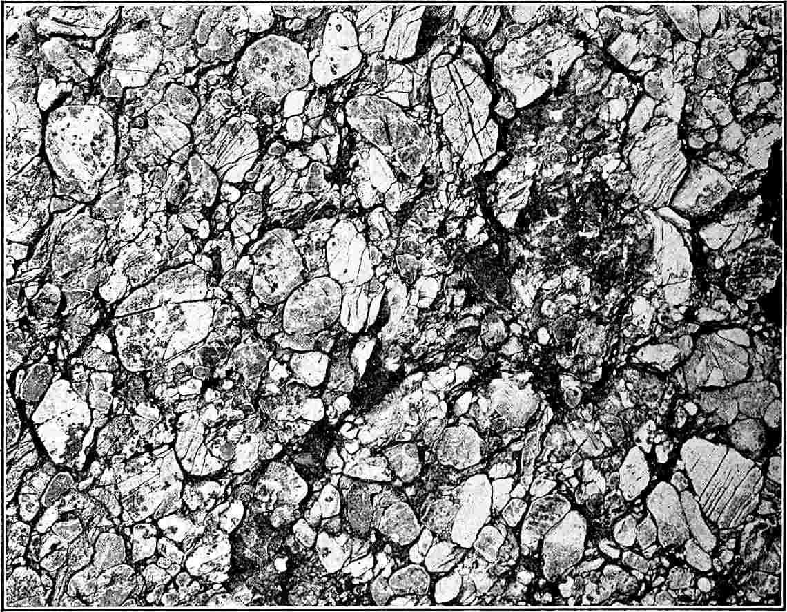
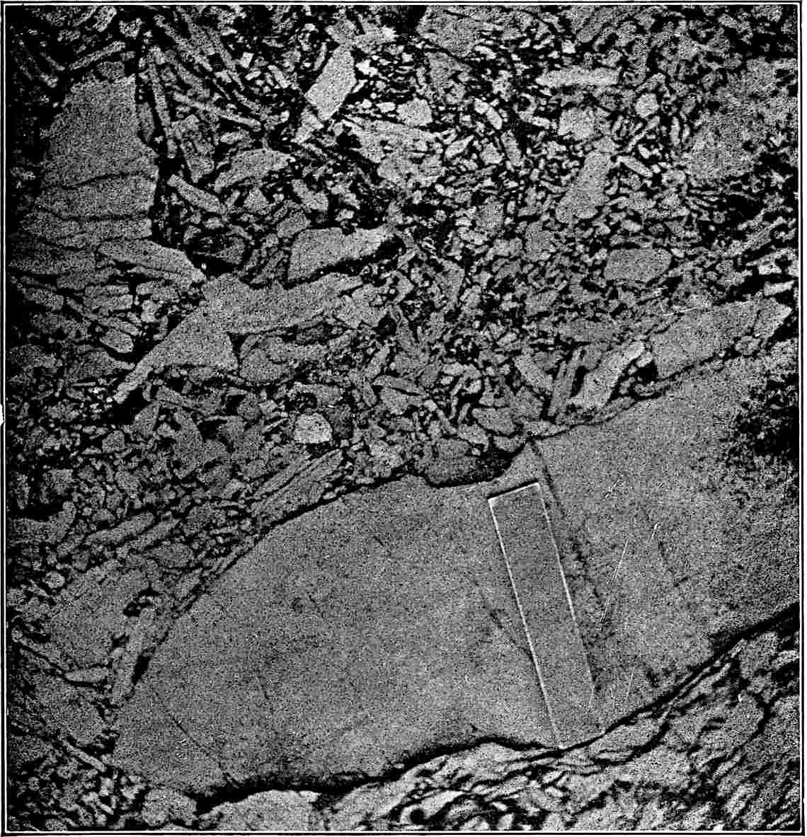
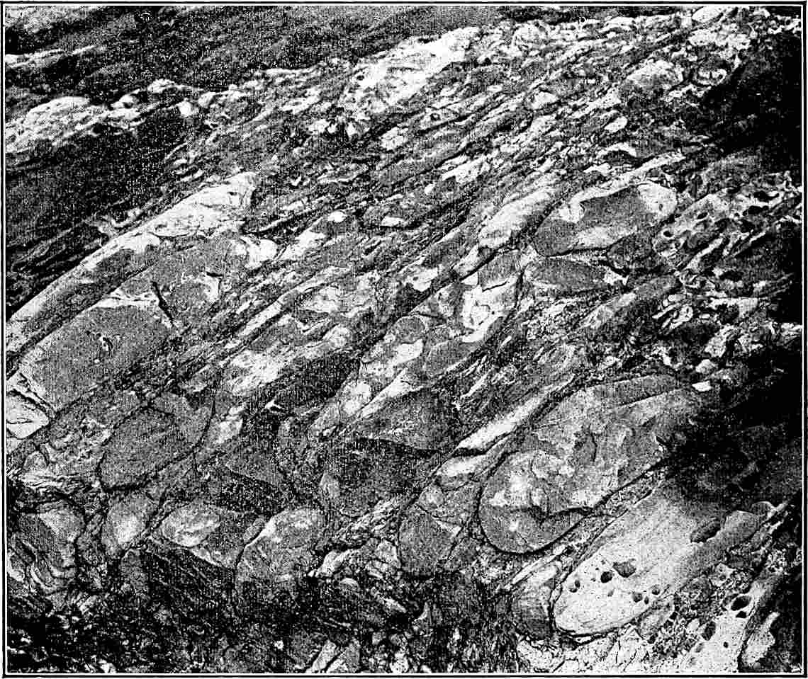
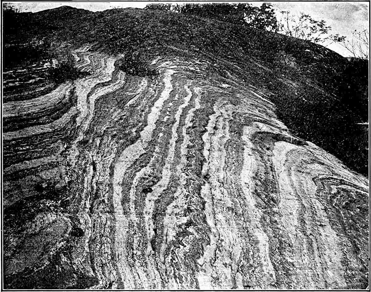
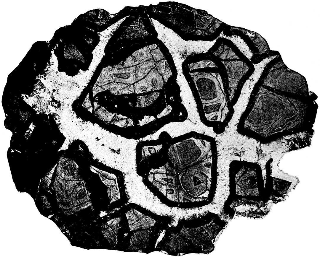
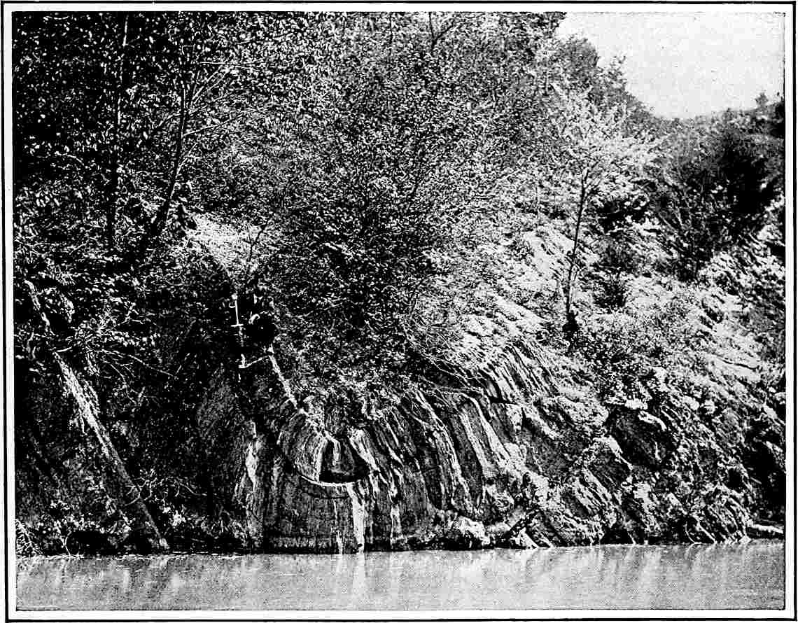
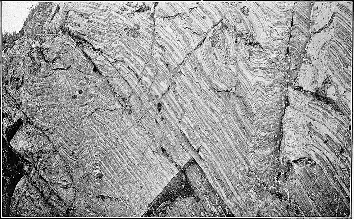
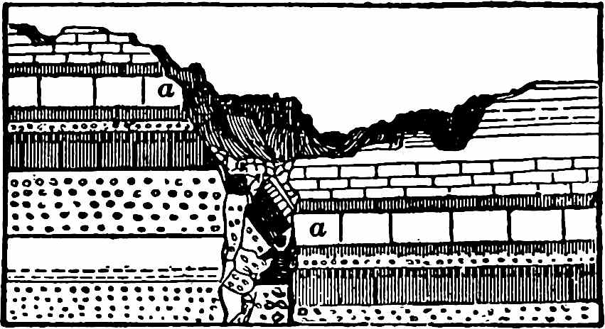
More commonly than otherwise the metamorphic rocks (Fig. 3) lie beneath
the sedimentary beds and are often broken through by the igneous rocks.
From their position in many places their great age may be inferred, but
locally, especially where dynamic action has been severe, relatively
young rocks are metamorphic.
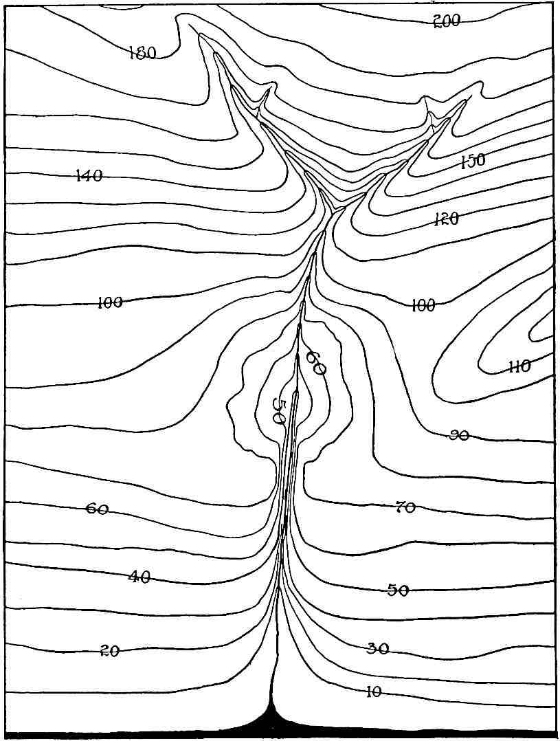
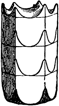
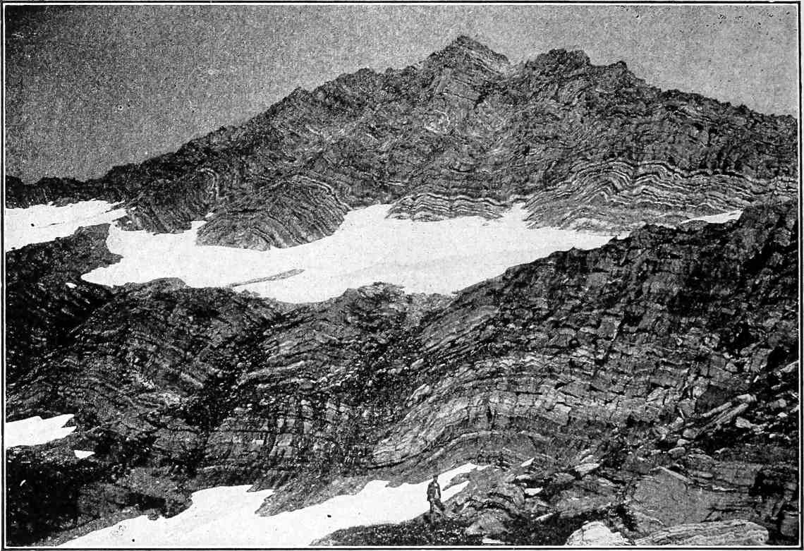
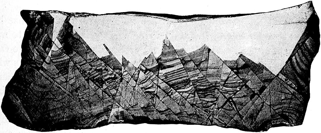
Fig. 3. The figure represents a section of the
earth about 1000 miles Long. The unequally thick black line at the
top represents on something like its proper scale the depth of the
stratified rock. The area below represents crystalline rock, largely
metamorphic.
Four great sedimentary eras.—The water-laid series represents
four great eras in the history of the earth, as shown by the relics
of life imbedded in them. Beginning with the latest, these are the
Cenozoic (recent life), during which the life took on its modern
aspect; the Mesozoic (middle life), during which the life bore
a mediæval aspect; the Paleozoic (ancient life), during which
the life belonged to older types; and the Proterozoic (earlier
life), during which it is inferred that much life prevailed, though
its record is very imperfect. It may safely be assumed to have been
more primitive than that of the Paleozoic, as it was earlier. Each
of these great divisions embraced several lesser periods or epochs,
and these again are subdivided more and more closely according to the
degrees of refinement to which studies are carried. The chief of these
subdivisions are given in the table on page 19, and others will come
under consideration in the historical chapters.
18
In these four great series of sedimentary rocks there are, here and
there, intrusions of igneous rocks, and in some places the sedimentary
beds have been metamorphosed into crystalline rocks by heat and
pressure. This is particularly true in the lowest of these series, the
Proterozoic, where a large part of the sediment is metamorphosed, and
where there is much igneous rock, but it is still clear that the main
portion of this series was originally water-laid sediment, and so it
belongs to the sedimentary series rather than the Archean, in which the
sediments are the minor rather than the main factor. It has, however,
usually been classed with the Archean, and it is certainly not always
easy to draw the dividing line. In a sense it may be regarded as a
transition series.
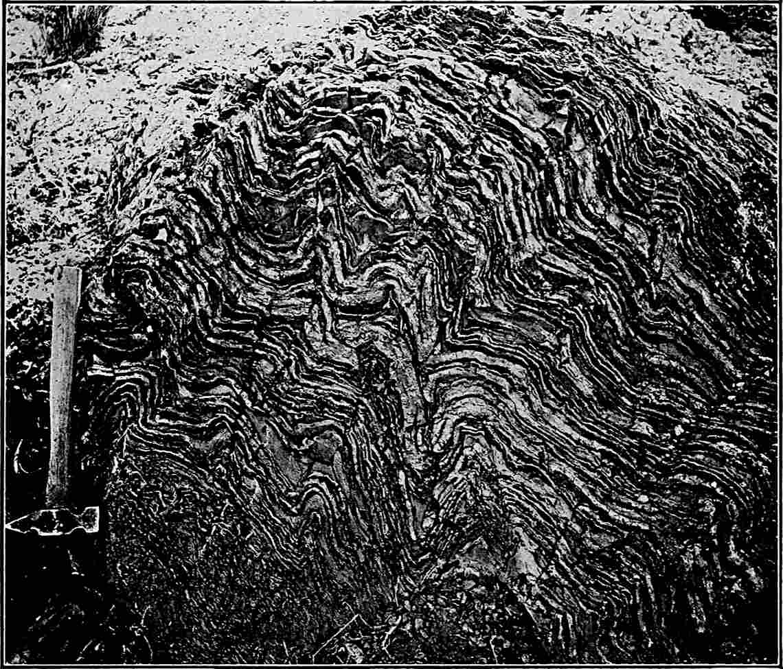
The Archean complex.—Beneath the dominantly sedimentary but
partly metamorphic and igneous series there is a very complex group of
rocks largely of metamorphosed igneous origin, though containing some
metamorphosed sediments. These extend downwards to unknown depths.
While all the great formations are occasionally bent and broken, these
lowest ones are almost everywhere warped, folded, and contorted, often
in the most intricate way. They have been very generally mashed and
sheared by enormous pressure, so that they have become foliated, and
their original character is much masked. They therefore form a series
of great obscurity and complexity. As they are at the bottom of the
known series, they have been called the “Fundamental gneiss” and the
“Basement complex,” but as the part which we see is not the true base
nor the true foundation, it is safer to call them simply the Archean
(very ancient) complex. As life appears to have been present during
a part at least of the period of its formation is referred to the
Archeozoic era.
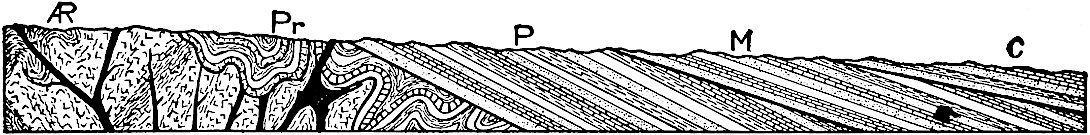
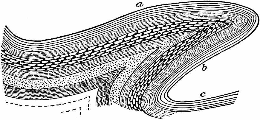
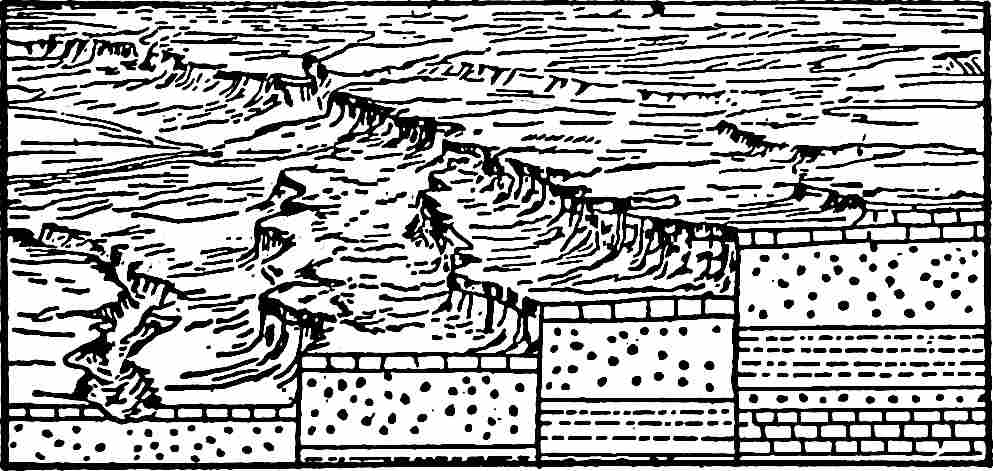
Fig. 4.—Diagram to illustrate the relations of
the five great groups of formations. AR = Archean, Pr
= Proterozoic, P = Paleozoic, M = Mesozoic, C =
Cenozoic.
Beyond and below this series, the structure of the earth is a matter
of inference. Vast as are the preceding series, they together form
relatively but a thin shell on the outer surface of the globe.
The foregoing series are diagrammatically expressed in Fig. 4, and
systematically presented to the eye in the following table.
19
GENERAL TABLE OF GEOLOGIC DIVISIONS.
Cenozoic
Present.
Pleistocene.
Pliocene.
Miocene.
Oligocene.
Eocene.
Transition (Arapahoe and Denver).
Mesozoic
Upper Cretaceous.
Lower Cretaceous (Comanche or Shastan).
Jurassic.
Triassic.
Paleozoic
Permian.
Coal Measures or Pennsylvanian.
Subcarboniferous, or Mississippian.
Silurian.
Devonian.
Ordovician.
Cambrian.
Great interval.
Proterozoic
Keweenawan.
Interval.
Animikean or Penokean. (Upper Huronian of some authors).
Interval.
Huronian.
Great interval.
Archeozoic
Archean Complex.
Great Granitoid Series. (Intrusive in the main, Laurentian.)
Great Schist Series. (Mona, Kitchi, Lower Keewatin, Coutchiching,
Lower Huronian of some authors.)
20
The purpose of this general survey is to bring the salient features
of the earth’s structure into view preparatory to entering in more
detail into the study of particular processes and special formations
and to lay a foundation for the fuller apprehension of the successive
stages of the history of the earth, which constitutes the chief purpose
of geological study. It is now advisable to turn to the detailed
consideration of individual processes and specific structures. The
complexity of the actions involved in the history of the earth is so
great that such separate consideration at the outset is helpful.
21
CHAPTER II.
THE ATMOSPHERE AS A GEOLOGICAL AGENT.
While it is convenient to regard the lithosphere as the earth proper,
and the atmosphere as its envelope, the latter is as truly a part of
the planet as the former, and its activities and its history are as
truly subjects of geological study as the formation of the rocks.
This view is in no way vitiated by the fact that the special study
of the atmosphere is set apart under the name Meteorology,
for in the same way the special study of rocks is set apart under
the name Petrology, that of ancient life under the name
Paleontology, and that of other phases of the subject under
other names. The atmosphere is one of the three great formations of
the earth, and as a geological factor takes its place beside the
hydrosphere and the lithosphere. It has played a part in the history
of the earth comparable to that of the water, though its mass is less
and its record more elusive. Unsubstantial as the atmosphere seems when
contrasted with the liquid and solid portions of the earth, its extreme
mobility and its chemical activity compensate for its lightness and
tenuity, and give it a function of the first order of importance.
The atmosphere plays a direct part as (1) a mechanical and (2) a
chemical agent, and at the same time serves an indirect function
in furnishing favorable conditions under which (3) solar radiation
produces temperature effects, and (4) evaporation gives origin
to precipitation and stream effects, and furnishes the necessary
conditions for land plants and animals, and the important influences
that spring from them.
This chapter is devoted to the work of the atmosphere in these and some
less notable phases. The consideration of the origin and history of the
atmosphere will receive attention later.
A. THE ATMOSPHERE AS A DIRECT AGENCY.
I. Mechanical Work.
The mechanical work of the atmosphere is accomplished chiefly through
its movement. A feeble breeze is competent to move particles22 of dust,
and winds of moderate velocity to shift sand. Exceptionally strong
winds sometimes move small pebbles, but winds of sufficient force to
move larger pieces of rock are rare. It follows, therefore, that the
impact of the wind has little direct effect except on surfaces covered
with dust and dry sand.
The transportation of material by the wind is limited by the size
of the particles to which it has access. Dust particles expose more
surface to the wind relative to their mass than sand grains. Winds
which are unable to carry sand may still carry dust, and winds which
are able to shift sand no more than a trivial distance may blow dust
great distances.
The common conception of wind as a horizontal movement of some part
of the atmosphere is not altogether accurate. Every obstacle against
which wind blows causes deflections of its currents, and some of these
deflections are upward. Furthermore, there are exceptional winds,
in which the vertical element predominates. Particles of dust are
often involved in these upward currents, and by them carried to great
heights, and in the upper air are transported great distances.
Transportation and deposition of dust.[3]—The universality of
the transportation of dust by the wind is well known. No house, no
room, and scarcely a drawer can be so tightly closed but that dust
enters it, and the movements of dust in the open must be much more
considerable. The visible dustiness of the atmosphere in dry regions
during wind-storms is adequate and familiar proof of the efficiency of
the wind as a transporter of dust.
Under special circumstances, opportunity is afforded for rough
determinations of the distance and height to which wind-blown dust is
transported. Snow taken from snow-fields in high mountain regions is
found to contain a small amount of earthy matter. Its particles are
often found to be in part volcanic, even when the place whence the snow
was taken is scores or even hundreds of miles from the nearest volcano.
There is probably no snow-field so high, or so far from volcanoes, but
that volcanic dust reaches it. If this be true of all snow-fields,
it is probably true of all land surfaces. In the great Krakatoa[4]
eruptions of 1883 large quantities of volcanic ash (pulverized lava)
were projected to great heights into the atmosphere. The coarser
particles 23soon settled; but, caught by the currents of the upper
atmosphere, many of the finer particles were transported incredible
distances. Through all their long journey, the particles of dust were
gradually settling from the atmosphere, but not until the dust had
traveled repeatedly round the earth did its amount become so small as
to cease to make its influence felt in the historic red sunsets which
it occasioned.[5] Some of this dust completed the circuit of the earth
in 15 days.
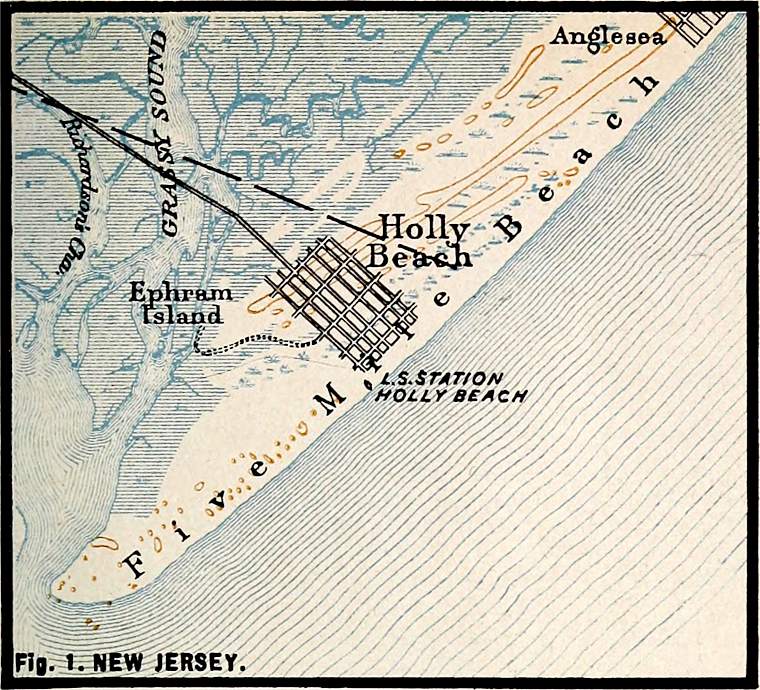
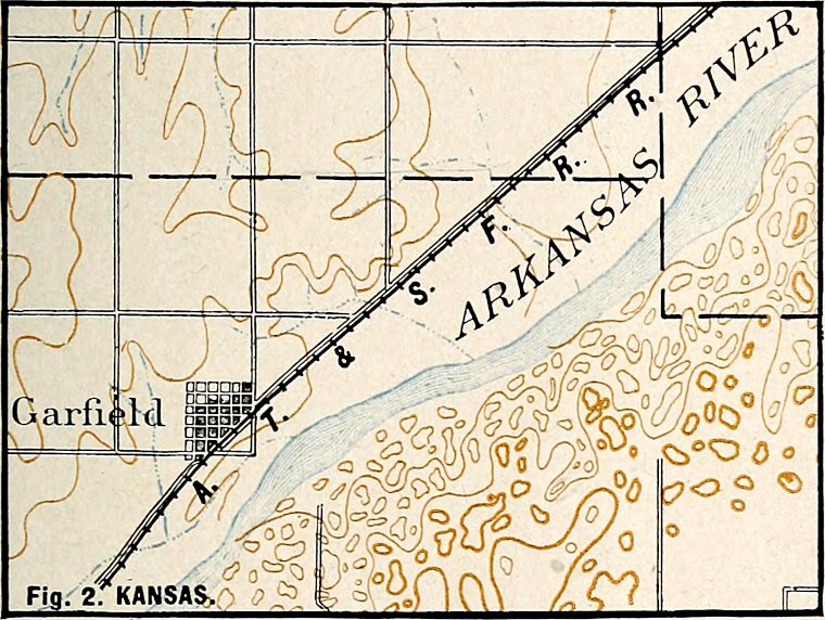
In various parts of Kansas and Nebraska[6] there are very considerable
beds of volcanic dust, locally as much as 30 feet thick, which must
have been transported from volcanic vents by the wind, though there
are no known centers of volcanic action, past or present, within some
hundreds of miles of some of the localities where the dust occurs.
These beds of volcanic dust, so far from its source, may serve as an
illustration of the importance of atmospheric movements as a geological
force.
Volcanic dust is shot into the atmosphere rather than picked up by
it. Dust picked up by the wind is perhaps transported not less widely
than volcanic dust, but, after settling, its point of origin is less
readily determined. It would perhaps be an exaggeration to say that
every square mile of land surface contains particles of dust brought to
it by the wind from every other square mile, but such a statement would
probably involve much less exaggeration than might at first be supposed.
Examples of extensive deposits of dust other than volcanic are also
known. In China there is an extensive earthy formation, the
loess, sometimes reaching 1,000 feet in thickness, which von
Richtofen believes to have been deposited by the wind.[7] This
conclusion has, however, not passed unchallenged.[8] The loess of some
other regions has been referred to the same origin, and some of it is
quite certainly eolian.[9]
The transportation of dust is important wherever strong winds blow over
dry surfaces, free or nearly free of vegetation, and composed of earthy
matter. Its effects may be seen in such regions as the sage-brush
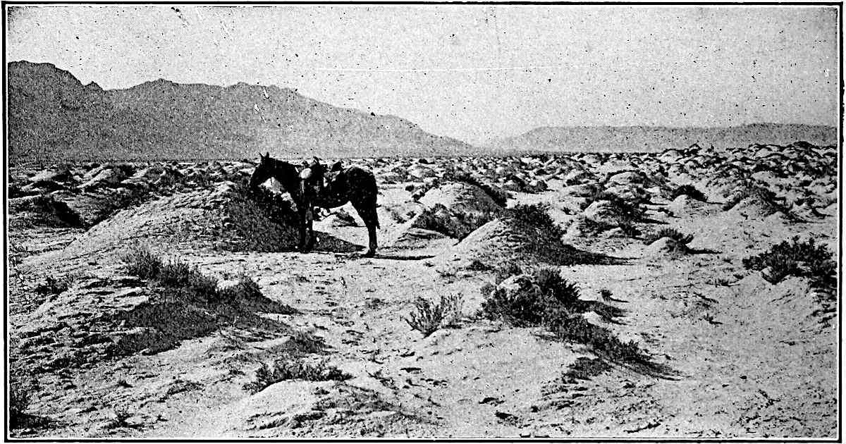
plains of western North America. The roots of the 24sage-brush hold the
soil immediately about them, but between the clumps of brush, where
there is little other vegetation, the wind has often blown away the
soil to such an extent that each clump of brush stands up several
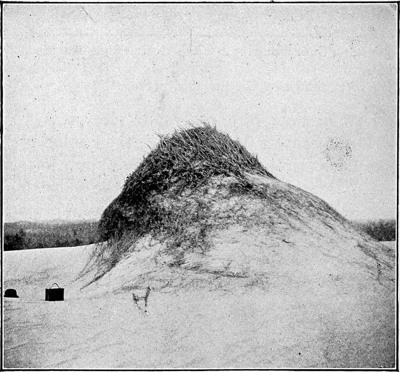
inches, or even a foot or two, above its surroundings (Fig. 5). Such
mounds are often partly due to the lodgment of dust about the bushes.
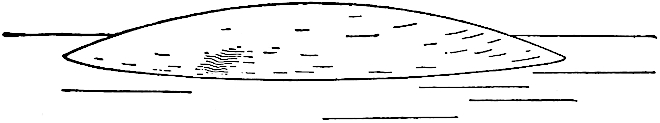
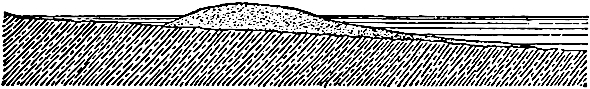
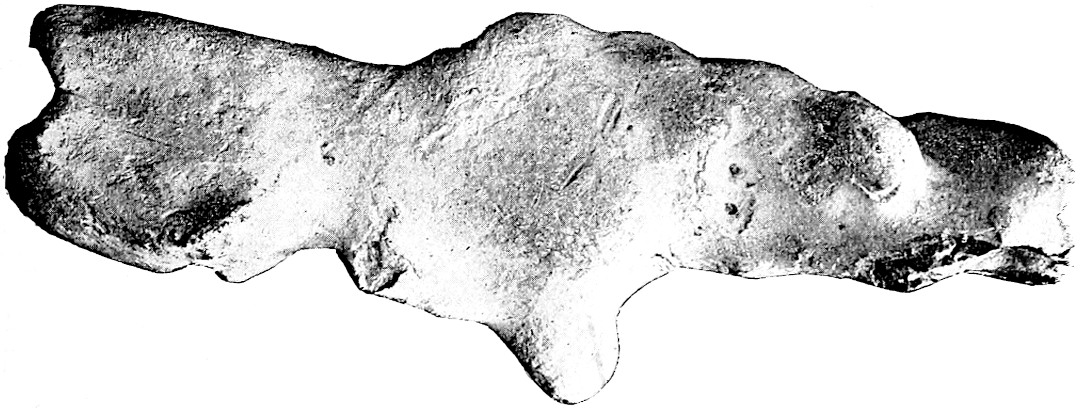
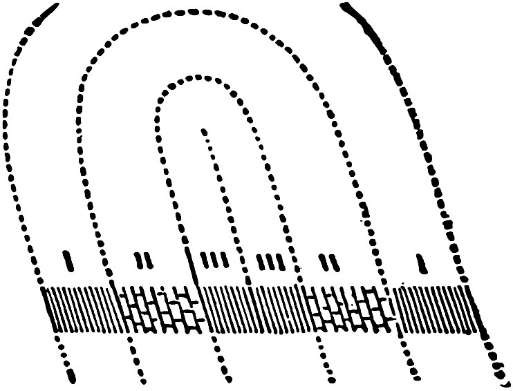
Fig. 5.—This figure shows the effect of
sage-brush or other similar vegetation in holding sand or earth, or in
causing its lodgment, in dry regions.
Where the earthy matter is moist, the cohesion of the particles is
great, and the wind cannot pick them up. Furthermore, if the surface
is generally moist, it is likely to be covered with vegetation which
protects it against the wind. But even where vegetation is prevalent
the wind finds many a vulnerable point. Thus on the edges of plains
or plateaus facing abrupt valleys, the wind attacks the soil from
the side, and in such situations all earthy matter may be stripped25
from the underlying rock for considerable distances from the edge of
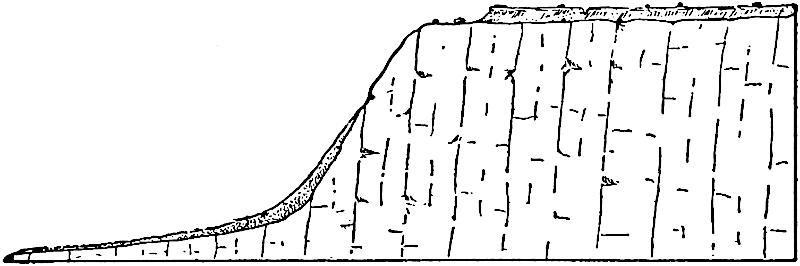
the cliff (Fig. 6). This may be seen at numerous points on the lava
plateaus of Washington.
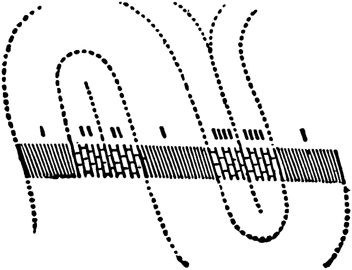
Fig. 6.—Diagram to illustrate the way in
which the wind sometimes strips the soil from the edge of a bluff.
This phenomenon is not rare in the basin of the Columbia River in
Washington.
The presence of dust in the upper atmosphere during a rain-storm is
sometimes the occasion of phenomena which are often misinterpreted. If
there be abundant dust in the atmosphere through which rain-drops or
snowflakes fall, much of it is gathered up by them, and the water is
thereby rendered turbid and the snow discolored. Here is to be found
the explanation of “mud-rain,” “blood-rain” (red dust), etc.
Since dust is carried to a considerable extent in the upper atmosphere,
its movements and its deposition are little affected by obstacles on
the surface of the land. A building or a hedge can only affect the
lodgment of that part of the atmospheric dust which comes in contact
with it or is swept into its lee. Since most obstacles on the surface
of the solid part of the earth reach up but slight distances into the
atmosphere, the dust of the greater part of the air settles without
especial reference to them, and is spread more or less uniformly over
the surface on which it falls.
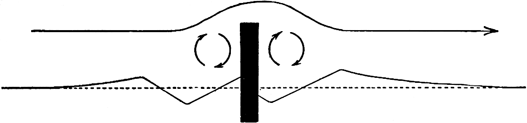
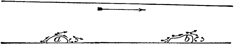
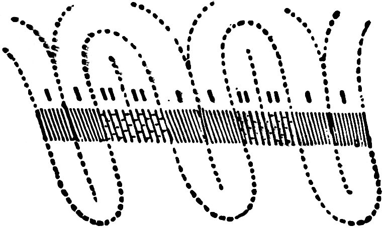
Fig. 7.—Diagram to illustrate the effect of an
obstacle on the transportation and deposition of sand. The direction of
the wind is indicated by the upper arrow. The lower arrows represent
the direction of eddies in the air occasioned by the obstacle. If the
surface in which the obstacle was set was originally flat (dotted
line), the sand would tend to be piled up on either side at a little
distance from the obstacle, but more to leeward. At the same time,
depressions would be hollowed out near the obstacle itself (see full
line). (After Cornish.)
Much of the dust transported by the wind is carried out over seas or
lakes and falls into them. By this means, sedimentation is doubtless
going on at the bottom of the whole ocean, and at the bottoms of all
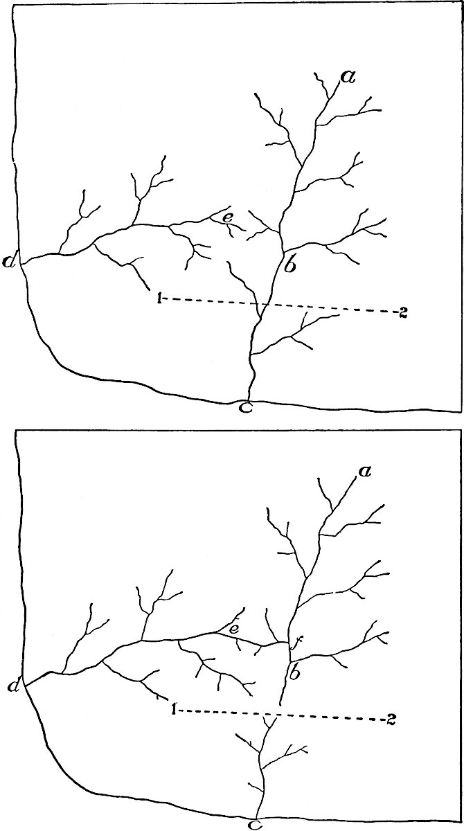
lakes. While means of determining the amount of dust blown into the
sea are not at hand, it is safe to say that, were such determinations
possible, the result, if stated in terms of weight, would be surprising.
Transportation and deposition of sand.—In its transportation by
the wind, sand is not commonly lifted far above the surface of the26
land, and its movement is therefore more generally interfered with by
surface obstacles than is the movement of dust. A shrub, a tree, a
fence, a building, or even a stone may occasion the lodgment of sand
in considerable quantity, though it has little effect on the lodgment
of dust. The effect of obstacles is illustrated by Fig. 7 (see also
Fig. 5). If the obstacle which occasions the lodgment of sand presents
a surface which the wind cannot penetrate, such as a wall, sand is
dropped abundantly on its windward side as well as on the leeward;
but if it be penetrable, like an open fence, the lodgment takes place
chiefly on its leeward side. In cultivated regions cases are known
where, in a few weeks of dry weather, sand has been drifted into lanes
in the lee of hedges to the depth of two or three feet, making them
nearly impassable to vehicles.
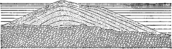
Formation of dunes.—In contrast with dust deposited from the
atmosphere, wind-blown sand is commonly aggregated into mounds and
ridges in the process of lodgment. These mounds and ridges are dunes.
Once a dune is started, it occasions the further lodgment of sand, and
is a cause of its own growth. Dunes sometimes reach heights of 200 or
300 feet, but they are much more commonly no more than 10 or 20 feet in
height. On plane surfaces, there is a limit in height above which they
do not rise, though the limit is different under different conditions.
The velocity of wind at the bottom of the air is not so great as that
higher up, and as a dune is built up, a level is presently reached
where the stronger upper winds sweep away as much sand as is brought to
the top. The very even crests of many dune ridges are probably to be
accounted for in this way. Wind-blown or eolian sand, not piled up in
heaps or ridges, is somewhat widespread, but does not constitute dunes.
Shapes of dunes.[10]—Dunes may assume the form of ridges or
of hillocks. The ridges may be transverse to the direction of the
prevailing wind or parallel with it. Where dunes assume the form of
hillocks rather than ridges, a group of them may be elongate in a
direction parallel to the dominant wind, or at right angles thereto.
The shape assumed by a dune or a group of dunes depends on the
abundance of the sand, the strength and direction of the wind, and the
shape of the obstacle which occasions the lodgment.
27
Fig. 8.—Dune ridges parallel to the direction
of the wind. Southwest part of India. Scale about 3 miles to the inch.
(Cornish.)Fig. 9.—Dune ridges transverse to the direction
of the wind. Scale about 3 miles to the inch. (Cornish.)
The incipient stages of dune formation are readily seen in many dry,
sandy regions. The dune is likely to start in the lee of some obstacle,
and to be elongate in the direction of the wind, especially if the wind
be strong relative to the supply of sand. This shape is permanently28
preserved if the proper relations between the supply of sand and
strength and direction of wind are preserved. In the dune region of the
Indian desert[11] the prevailing winds are alternately the southwest
and northeast monsoons, the former being the stronger. The supply
of sand comes from the southwest. Near the southwest coast the dune
ridges are parallel to the direction of the wind (Fig. 8); in the
interior, where the winds are less strong, the dunes are transverse to
it (Fig. 9); while between the districts where these two types prevail
intermediate forms occur. The transverse dune ridges (Fig. 9) are said
to be the result of the lateral growth and erosion of longitudinal
dunes.[12] In regions of changeable winds the shape of the dunes
is subject to great variation. Dunes are sometimes crescentic, the
convexity facing the wind (Fig. 10).
Fig. 10.—Crescentic dunes in ground-plan, the
convexities facing the wind. (Bokhara.) (Walther.)
29
Along coasts, dune ridges are often transverse to the wind, and groups
of dune hillocks are frequently elongate in the same direction. Here
the source of supply of the sand is itself an elongate belt, often
transverse to the dominant wind, and the resulting dunes often have
great length transverse to the wind. Where the wind has strong mastery
over the sand, the longitudinal tendency is seen, even along coasts.[13]
Fig. 11.—Section of a dune showing, by the
dotted line, the steep leeward (bc) and gentler windward
(ab) slope. By reversal of the wind the cross-section may be
altered to the form shown by the line adc. (Cornish.)Fig. 12.—Cross-section of a dune showing the
profiles developed by scour of the wind on both flanks. (Cornish.)
The shapes of dunes in section, like the shapes in ground-plan, depend
on the relative strength and constancy of the winds and the supply of
sand. With constant winds and abundant drifting sand, dunes are steep
on the lee side (bc, Fig. 11), where the angle of slope is the
angle of rest for the sand. It rarely exceeds 23° or 24°.[14] Under the
same conditions the windward slope is relatively gentle (ab,
Fig. 11). If the winds be variable so that the windward slope of one
period becomes the leeward slope of another, and vice versa, this
form is not preserved. Thus, by reversal of the wind, the section
abc, Fig. 11, may be changed to adc. If the winds and
the supply of sand be equal, on the average, from opposite directions,
the slopes should, on the average, be equal, though perhaps unequal
after any particular storm. The steep slopes of new-made dunes are
lost after the sand has ceased to be blown. At some points where the
winds erode (scour) more than they deposit, new profiles are developed
(Figs. 12 and 13). The erosion profiles may be very irregular if the
dunes are partially covered with vegetation. The effect of vegetation
in restraining wind erosion is shown in Fig. 14, where plants have
preserved a remnant of a dune.
30
The topographic map.—Since dunes as well as other
topographic features are conveniently represented on contour maps,
and since such maps will be used frequently in the following pages,
a general explanation of them is here introduced.
“The features represented on the topographic map are of three
distinct kinds: (1) inequalities of surface, called relief,
as plains, plateaus, valleys, hills, and mountains; (2)
distribution of water, called drainage, as streams, lakes,
and swamps; (3) the works of man, called culture, as roads,
railroads, boundaries, villages, and cities.
Fig. 13.—Diagram showing the outline of
dunes in process of destruction. Seven Mile Beach, N. J. (N. J.
Geol. Surv.)Fig. 14.—Illustrates the protective effect
of vegetation against wind erosion. Dune Park, Ind. (Cowles)
Relief.—All elevations are measured from mean sea-level.
The heights of many points are accurately determined, and those
which are most important are given on the map in figures. It is
desirable, however, to give the elevation31 of all parts of the
area mapped, to delineate the horizontal outline, or contour, of
all slopes, and to indicate their grade or degree of steepness.
This is done by lines connecting points of equal elevation
above mean sea-level, the lines being drawn at regular vertical
intervals. These lines are called contours, and the uniform
vertical space between each two contours is called the contour
interval. On the maps of the United States Geological Survey
the contours and elevations are printed in brown (see Plate II).
Fig. 15.—Sketch and map of the same area
to illustrate the representation of topography by means of contour
lines (U. S. Geol. Surv.)
The manner in which contours express elevation, form, and grade is
shown in the following sketch and corresponding contour map, Fig.
15.
The sketch represents a river valley between two hills. In the
foreground is the sea, with a bay which is partly closed by a
hooked sand bar. On each side of the valley is a terrace. From
the terrace on the right a hill rises gradually, while from that
on the left the ground ascends steeply in a precipice. Contrasted
with this precipice is the gentle descent of the slope at the left.
In the map each of these features is indicated, directly beneath
its position in the sketch, by contours. The following explanation
may make clearer the manner in which contours delineate elevation,
form, and grade:
32
1. A contour indicates approximately a certain height above
sea-level. In this illustration the contour interval is 50 feet;
therefore the contours are drawn at 50, 100, 150, 200 feet, and
so on, above sea-level. Along the contour at 250 feet lie all
points of the surface 250 feet above sea; and similarly with any
other contour. In the space between any two contours are found
all elevations above the lower and below the higher contour. Thus
the contour at 150 feet falls just below the edge of the terrace,
while that at 200 feet lies above the terrace; therefore all points
on the terrace are shown to be more than 150 but less than 200
feet above sea. The summit of the higher hill is stated to be 670
feet above sea; accordingly the contour at 650 feet surrounds it.
In this illustration nearly all the contours are numbered. Where
this is not possible, certain contours—say every fifth one—are
accentuated and numbered; the heights of others may then be
ascertained by counting up or down from a numbered contour.
2. Contours define the forms of slopes. Since contours are
continuous horizontal lines conforming to the surface of the
ground, they wind smoothly about smooth surfaces, recede into
all reëntrant angles of ravines, and project in passing about
prominences. The relations of contour curves and angles to forms of
the landscape can be traced in the map and sketch.
3. Contours show the approximate grade of any slope. The vertical
space between two contours is the same, whether they lie along a
cliff or on a gentle slope; but to rise a given height on a gentle
slope one must go farther than on a steep slope, and therefore
contours are far apart on gentle slopes and near together on steep
ones.
For a flat or gently undulating country a small contour interval
is used; for a steep or mountainous country a large interval is
necessary. The smallest interval used on the atlas sheets of the
Geological Survey is 5 feet. This is used for regions like the
Mississippi delta and the Dismal Swamp. In mapping great mountain
masses, like those in Colorado, the interval may be 250 feet. For
intermediate relief contour intervals of 10, 20, 25, 50, and 100
feet are used.
Drainage.—Watercourses are indicated by blue lines. If the
streams flow the year round the line is drawn unbroken, but if the
channel is dry a part of the year the line is broken or dotted.
Where a stream sinks and reappears at the surface, the supposed
underground course is shown by a broken blue line. Lakes, marshes,
and other bodies of water are also shown in blue, by appropriate
conventional signs.
Culture.—The works of man, such as road, railroads, and
towns, together with boundaries of townships, counties and states,
and artificial details, are printed in black.”[15]
Topography of dune areas.—From what has been said, it is clear
that the topography of dune regions may vary widely, but it is always
distinctive. Where the dunes take the form of ridges (Fig. 1, Pl.
II), the ridges are often of essentially uniform height and width for
considerable distances. If there are parallel ridges, they are often
separated 33by trough-like depressions. Where dunes assume the form of
hillocks (Figs. 2 and 3, Pl. II), rather than ridges, the topography
is even more distinctive. In some regions, depressions (basins) are
associated with the dune hillocks. Occasionally they are hardly less
notable than the dunes themselves. A somewhat similar association of
hillocks and basins is locally developed by other means, but dunes are
made up of sand and usually of sand only, while the composition of
similarly shaped hillocks and depressions shaped by other agencies is
notably different.
In Fig. 1, Plate II (Five Mile Beach, 8 miles northeast of Cape
May, N. J.), the contour interval is 10 feet. There is here but one
contour line (the 10-foot contour), though this appears in several
places. Since this line connects places 10 feet above sea-level,
all places between it and the sea (or marsh) are less than 10
feet above the water, while all places within the lines have an
elevation of more than 10 feet. None of them reaches an elevation
of 20 feet, since a 20-foot contour does not appear. It will be
seen that some of the elevations in Fig. 1 are elongate, while
others have the form of mounds.
Fig. 2 (Pl. II) shows dune topography along the Arkansas River in
Kansas (near Larned); Fig. 4, dune topography in Nebraska (Lat.
42°, Long. 103°), not in immediate association with a valley or
shore; and Fig. 3 shows irregular ridge-like dunes at the head of
Lake Michigan. In Fig. 2 the contour interval is 20 feet. All the
small hillocks southeast of the river are dunes. Some of them are
represented by one contour and some by two. The altitude of the
region is considerable, the heavy contour representing an elevation
of 2100 feet; but the dunes themselves are rarely more than 20 feet
above their surroundings. In Fig. 4, where the contour interval is
also 20 feet, there are, besides the numerous hillocks, several
depressions (basins). These are represented by hachures inside the
contour lines. In some cases there are intermittent lakes (blue) in
the depressions. The heavy contour at Spring Lakes in this figure
is the contour of 4300 feet. There are two depression contours
(4280 and 4260) below it. The bottom of the depression is therefore
lower than 4260, but not so low as 4240. In Fig. 3 the contour
interval is 10 feet, and the dune ridges north of Miller are more
than 50 feet high. The dune ridges here have helped to determine
the position of this branch of the Calumet River, and have blocked
its former outlet. The present drainage is to the westward.
Migration of dunes.—By the continual transfer of sand from its
windward to its leeward side, a dune may be moved from one place to
another, though continuing to be made up, in large part, of the same
sand. In their migration dunes sometimes invade fertile lands, causing
so great loss that means are devised for stopping them. The simplest
method (employed in France and Holland) is to help vegetation to get
a foothold in the sand. The effect of the vegetation is to pin the34
sand down. As a dune ridge along a coast travels inland, another may be
formed behind it. Successions of dune ridges are thus sometimes formed.
Fig. 16.—Diagram illustrating the migration of
dunes on the Kurische Nehrung. (Credner.)
A remarkable instance of the migration of a sand dune is recorded
on the Kurische Nehrung on the north coast of Germany. The Nehrung
consists of a long narrow neck of land composed of sand, lying
off the main coast. At the beginning of this century there was a
notable dune ridge on one side. Since that time it has migrated a
considerable distance, and in its migration it has been brought into
the relationships illustrated in the accompanying diagrams (Fig. 16).
In 180035 the dune ridge was on one side of a church, which was then in
use. In 1839 the ridge had been so far shifted to the leeward as to
completely bury the church, and in 1869, its migration had progressed
so far as to again discover the building.[16]
Fig. 17.—Migration of dunes into a timbered
region. Dune Park, Ind. Head of Lake Michigan. (Meyers.)
When dunes migrate into a timbered region they bury and kill the trees
(Fig. 17). In one instance on the coast of Prussia a tall pine forest,
covering hundreds of acres, was destroyed during the brief period
between 1804 and 1827.[17] At some points in New Jersey orchards have
been so far buried within the lifetime of their owners that only the
tops of the highest trees are exposed. Trees and other objects once
buried may be again discovered by farther migration of the sand (Figs.
18 and 19).[18]
Fig. 18.—A resurrected forest. The dune sand
after burying and killing the timber has been shifted beyond it. Dune
Park. Ind. (Meyers.)
Eolian sand, not aggregated into distinct dunes, is often destructive.
Even valleys and cities are sometimes buried by it. Drifting sands had
so completely buried Nineveh two centuries after its destruction that
its site was unknown.
Distribution of dunes.—Dunes are likely to be developed wherever
dry sand is exposed to the wind. Their favorite situations are the
36dry and sandy shores of lakes and seas, sandy valleys, and arid sandy
plains.
Along coasts, dunes are likely to be extensively developed only where
the prevailing winds are on shore. Thus about Lake Michigan, where the
prevailing winds are from the west, dunes are abundant and large on the
east shore, and but few and small on the west. In shallow water, shore
currents and storm waves often build up a reef of sand a little above
the normal level of the water. When the waves subside, the sand dries
and the wind heaps it up into dunes. This sequence of events is in
progress at many points on the Atlantic Coast. Sandy Hook, New Jersey,
and the “beaches” farther south started as barrier ridges. When the
waves had built them above normal water-level, the wind re-worked the
sand, piling it up into mounds and hillocks (Fig. 1, Pl. II). Such dune
belts a little off shore are sometimes turned to good account. They are
usually separated from the mainland by a shallow lagoon. Where land
is valuable, the lagoon is sometimes filled in, making new land, thus
anticipating the result which nature would achieve more slowly. This
has been done at some points on the western coast of Europe.
Fig. 19.—Migration of dune sand exposing bones
in a cemetery. Hatteras Island, N. C. (Collier Cobb.)
Dunes are likely to occur along stream valleys (Fig. 2, Pl. II), if
their bottoms or slopes are of sand, and not covered by vegetation.
Dunes along valleys are usually on the side toward which the
prevailing winds blow. Thus they are more common on the east side of
the Mississippi than on the west. Dunes may be formed in the valley37
bottoms, but the sand is often blown up out of the valley and lodged on
the bluffs above.
Apart from these special classes of situations, any sandy region the
surface of which is dry is likely to have its surface material shifted
by the wind and piled up into dune ridges or hillocks (Fig. 4, Pl.
II). Dunes probably reach their greatest development in the Sahara,
where some of them take the form of hillocks, and some the form of
ridges. Travelers in that region report that dune ridges are sometimes
encountered the faces of which are so high and steep as to be difficult
of ascent, and that parties have been obliged to travel miles along
their bases before finding a break where crossing was practicable.
Fig. 20.—Wind-ripples. (Cross, U. S. Geol.
Surv.)
Wind-ripples.—The surface of the dry sand over which the wind
has blown for a few hours is likely to be marked with ripples (Fig.
20) similar to those made on a sandy bottom beneath shallow water,
under the influence of waves. Like ripple marks made by the water,
wind-ripples have one side (the lee) steeper than the other. While the
ripples are, as a rule, but a fraction of an inch high, they throw
much38 light on the origin of the great dune ridges. If the ripples
be watched closely during the progress of a wind-storm, they are
found gradually to shift their position. Sand is blown up the gentler
windward slope to the crest of the ridge and falls down on the other
side. The moment it falls below the crest of the ridge to leeward, it
is protected against the wind, and is likely to lodge. Wear on the
windward side is about equal to deposition on the leeward, and the
result is the orderly progression of the ripples in the direction in
which the wind is blowing, just as in the case of dune ridges.
Abrasion by the wind.—While the effect of the wind on sandy
and dusty surfaces may be considerable, its effect on solid rock is
relatively slight and accomplished, not by its own impact, but by that
of the material it carries. The effect of blown sand on rock surfaces
over and against which it is driven is perhaps best understood by
recalling the effects of artificial sand-blasts, by means of which
glass is etched. In a region where sand is blowing, exposed surfaces
of rock suffer from a multitude of blows struck by the sand grains in
transit. The result is that such rock surfaces are worn, and worn in a
way peculiar to the agency accomplishing the work. If the rock be made
up of laminæ which are of unequal hardness, the blown sand digs out
the softer ones, leaving the harder projecting as ridges between them.
Adjacent masses of harder and softer rock of whatever thickness are
similarly affected. The sculpturing thus effected on projecting masses
of rock is often picturesque and striking (Figs. 21 and 22), and is
most common in arid regions. Details of wind-carving are shown in Fig.
23.
Fig. 21.—Wind-carved rock. (Green.)
PLATE II.
U. S. Geol. Surv.
Scale, 1+ mile per inch.
Fig. 1. NEW JERSEY.
U. S. Geol. Surv.
Scale, 2+ mile per inch.
Fig. 2. KANSAS.
U. S. Geol. Surv.
Scale, 1+ mile per inch.
Fig. 3. INDIANA.
U. S. Geol. Surv.
Scale, 2+ mile per inch.
Fig. 4. NEBRASKA.
39
Sand drifted over loose stones lying on the surface often develops
flat or flattish faces or facets on them. These facets are likely to
be three in number, and the exposed portion of the stone is likely to
develop a sort of pyramidal shape, the three flattish surfaces being
mutually limited by tolerably well-defined lines (Fig. 24). Thus arise
the three-faceted stones (Dreikanter of the Germans) commonly
seen where sands have been long in movement.
Fig. 22.—Wind-carved hillock of cross-bedded
sandstone. Missouri River, Montana. (Calhoun, U. S. G. S.)
Not only does the drifting sand wear the surface over which it passes
and against which it strikes, but the grains themselves are worn in the
process. They are liable to be broken as they strike rock surfaces, and
they are likely to strike one another in the atmosphere. In both cases
they are subject to wear, and so to reduction to a finer and finer
state.
The erosion accomplished by the wind is therefore of various sorts. The
impact of the wind itself picks up the fine materials which are already
loosened, thus wearing down the surface from which they are removed;
the materials picked up wear the rock surfaces against which they are
blown, and the transported materials themselves suffer reduction in
transit.
Effects of wind on plants.—Another effect of wind work is
seen in the uprooting of trees (Fig. 25). The uprooting disturbs the
surface41 in such a way as to make loose earth more readily accessible
to wind and water. The uprooting of trees on steep slopes often causes
the descent of considerable quantities of loose rock and soil. Again,
organisms of various sorts (certain types of seeds, germs, etc.), as
well as dust and sand, are extensively transported by the wind. While
this is important biologically its geological effects are remote.
Fig. 23.—Figure showing details of wind-carving
on rock surface (rhyolite). Mono Valley, California.Fig. 24.—Wind-worn stones (Dreikanter).Fig. 25.—Shows the disturbance of surface earth
and rocks by upturning of trees. (Darton, U. S. Geol. Surv.)
Indirect effects of the wind.—Other dynamic processes are called
into being or stimulated by the atmosphere. Winds generate both waves
and currents, and both are effective agents in geological work. The
results of their activities are discussed elsewhere.
II. The Chemical Work of the Atmosphere.
The chemical work of the atmosphere (including solution and
precipitation from solution) is principally accomplished in connection
with water, a dry atmosphere having relatively little direct chemical
effect on rock or soils.
Precipitation from solution.—The water in the soil is constantly
evaporating. Such substances as it contains in solution are deposited
where the water evaporates, and where evaporation is long continued42
without re-solution of the substances deposited, the surface becomes
coated with an efflorescence of mineral matter. Conspicuous examples
are found in the alkali plains of certain areas in the western part of
the United States. Since the alkaline efflorescence is the result of
evaporation it is connected with the atmosphere, but the material of
the efflorescence was brought to its present position by water. The
principle involved is illustrated by the white efflorescence which
frequently appears on brick walls during the dry days which follow a
drenching rain. The water penetrates the brick and mortar and dissolves
something of their substance, and when it is evaporated from the
surface the material in solution is left behind.
In arid regions the deposition of substances other than alkali is
common. The percolating waters dissolve whatever is soluble, and when
they evaporate their mineral content is left. The pebbles and stones of
the arid plains have in many places become heavily coated with mineral
matter deposited in this way, and not infrequently cemented into
conglomerate. One of the commonest mineral substances found in such
situations is lime carbonate. In some cases it was doubtless derived
by solution from limestone beds beneath the surface, but this is not
always the case. It often encrusts the bits of lava on lava plains
where it can hardly have been derived from limestone. The faces of
cliffs of granite or gneiss, hundreds and even thousands of feet above
all other sorts of rock,[19] are sometimes spotted with patches of lime
carbonate. In the first case the lime carbonate was derived by chemical
change from the lava, and in the second, from the granite or gneiss
(see Carbonation below), but its present position is the result
of evaporation.
Oxidation.—In the presence of moisture the oxygen of the air
enters into combination with various elements of the soil and rocks.
This is oxidation. No other common mineral substance shows the
results of oxidation so quickly and so distinctly as iron. The oxidized
portion is loose and friable, and a mass of iron exposed to a moist
atmosphere will ultimately crumble away. This change is comparable to
other less obvious changes taking place in many minerals at and below
the surface. Oxidation generally involves the disintegration of the
rock concerned. Its effects in this direction will be referred to in
other connections.
43
Carbonation.—The production of lime carbonate from rock
containing calcium compounds, but not in the form of carbonates, is
known as carbonation, and is one of the important chemical
changes effected by the carbon dioxide of the atmosphere in coöperation
with water. In the process of carbonation the original minerals of
complex composition are decomposed and simpler ones usually formed.
Volumetric changes are involved, which often lead to the disruption of
the rock (see Ground water). Furthermore, carbonates are among
the more soluble minerals, and their production therefore brings some
of the rock materials into a soluble condition, and their extraction
through solution tends still further to disintegrate the rock. The
carbonation of crystalline rocks is therefore a disintegrating process,
and will be considered further in its many concrete applications.
Other chemical changes.—A third chemical process which often
accompanies oxidation and carbonation is hydration. This is
effected by water rather than by air, and will be considered in
that connection. In general it leads to the disintegration of the
minerals and rocks affected. The chemical effects of nitric acid,
etc., developed through the agency of atmospheric electricity, and
the corresponding effects of the gases and vapors which issue from
volcanoes, many of them chemically active, are to be mentioned in this
connection.
Conditions favorable for chemical changes.—Conditions are not
everywhere equally favorable for the chemical work of the atmosphere.
In general, high temperatures facilitate chemical action, and, other
things being equal, rocks are more readily decomposed by atmospheric
action in warm than in cold regions. Chemical activity is probably
greater where the climate is continuously warm than where there are
great changes of temperature. Changes of temperature, on the other
hand, tend to disrupt rock, and thus increase the amount of surface
exposed to chemical change. Since nearly all the chemical changes
worked by the atmosphere on the rocks are increased by the presence of
moisture, the chemical activity of the atmosphere is greater in moist
than in dry regions.
B. THE ATMOSPHERE AS A CONDITIONING AGENCY.
The most obvious mechanical work of the atmosphere is effected by the
wind, but mechanical results of great importance, conditioned by the
atmosphere, are also effected when the air is still.
44
I. Temperature Effects.
When the sun shines on bare rock its surface is heated and expanded,
and the expanded particles crowd one another with great force. Since
rock is a poor conductor of heat its surface is heated and expanded
notably more than parts beneath the surface. It follows that strains
are set up between the expanded outer portion and the cooler and less
expanded parts within. In the cooling of the same rock mass it is the
outermost portion which cools first and fastest, and, contracting as
it cools, strains are again set up between the outer part, which is
cooled more, and the inner part, which is cooled less. The result may
be illustrated by the effect of cold water on hot glass, or of hot
water on cold glass. In either case the fracture is the result of the
sudden and considerable differential expansion or contraction. Since
the heating and cooling of rock are much slower than the heating and
cooling of glass under the conditions mentioned, the rupturing effects
are less conspicuous, but none the less real. The actual effects
of temperature changes are illustrated by familiar phenomena. The
surface portions of bowlders exposed to the sun are frequently seen
to be shelling off (Fig. 26). The loosened concentric shells may be a
fraction of an inch, or sometimes even several inches in thickness.
This process of exfoliation affects not only bowlders, but bare
rock surfaces wherever exposed to the sun (Figs. 27, 28). It is often
conspicuous on the faces of cliffs.
Fig. 26.—Exfoliation. A bowlder of weathering,
the rock being granite. Wichita Mountains, Oklahoma.
45
Fig. 27.—A weathered summit of granite in the
Wichita Mountains. Oklahoma. (Willis, U. S. Geol. Surv.)
Several conditions, some of which are connected with the atmosphere and
some with the rock, determine the efficiency of this process. Since
the breaking of the rock results from the expansion and contraction
due to its changes of temperature, it follows that, other things
being equal, the greater the change, the greater the breaking; but
the suddenness of the temperature change is even more important than
its amount. It follows that great daily, rather than great annual,
changes of temperature[20] favor rock-breaking, though with changes
of a given frequency their effectiveness is greater the greater their
range. A partial exception to this generalization should be noted.
If abundant moisture is present in the pores and cracks of the rock
a change of temperature from 45° to 35° (Fahr.) might be far less
effective in breaking the rock than a change from 35° to 25° in the
same time, for in the latter case the sudden and very considerable
expansion (about one-tenth) which water undergoes on freezing is
brought into play. This may be called the wedge-work of ice.
The daily range of temperature is influenced especially by latitude,
46altitude, and humidity. Other things being equal, the greatest daily
ranges of temperature occur in high-temperate latitudes, though to
this general statement there are local exceptions, depending on other
conditions. High altitudes favor great daily ranges of temperature, so
far as the rock surface is concerned (see Figs. 29, 30), for though
the rock becomes heated during the sunny day, the thinness and dryness
of the atmosphere allow its heat to radiate rapidly at night. Here,
too, the daily range of temperature is likely to bring the wedge-work
of ice into play. Since the south side of a mountain (in the northern
hemisphere) is heated more than the north, it is subject to the greater
daily range of temperature, and the rock on this side suffers the
greater disruption. Similarly, rock surfaces on which the sun shines
daily are subject to greater disruption than those much shielded by
clouds. Isolated peaks, because of their greater exposure, are subject
to rather greater daily ranges of temperature than plateaus of the same
elevation.
Fig. 28.—Exfoliation on a mountain slope. Mt.
Starr-King (Cal.) from the north.
The daily range of temperature is also influenced by humidity. Because
of the effect of water vapor in the atmosphere on insolation47 and
radiation, a rock surface becomes hotter in the day and cooler at night
beneath a dry atmosphere than beneath a moist one. Aridity therefore
favors the disruption of rock by changing temperatures.
Turning from the conditions of the atmosphere which affect the
disruption of rock to the conditions of the rock which influence the
same process, several points are to be noted. In the first place, the
disrupting effects of changes of temperature are slight or nil where
the solid rock is protected by soil, clay, sand, gravel, snow, or other
incoherent material. If the constituent parts of the loose material are
coarse, like bowlders, their surfaces are affected like those of larger
bodies of rock. The color of rock, its texture and its composition,
also influence its range of daily temperature by influencing absorption
and conduction. Dark-colored rocks absorb more heat than light-colored
ones, and compact rocks are better conductors than porous ones. Great
absorption48 and slow conduction favor disruption. A given range of
temperature is unequally effective on rocks of different mineral
composition. In general crystalline rocks (igneous and metamorphic) are
more subject to disruption by this means than sedimentary rocks, partly
because they are more compact, but especially because they are made up
of aggregates of crystals of different minerals which, under changes of
temperature, expand and contract at different rates, while the common
sedimentary rocks are made up largely of numerous particles of one
mineral.
Fig. 29.—Top of Notch Peak, Bighorn Mountains,
Wyo. Shows the thoroughly broken character of the rock on the summit,
the absence of soil, vegetation, etc. (Kümmel.)Fig. 30.—A detail from Fig. 29 showing the size
of the rock blocks. (Kümmel.)Fig. 31.—Peak north of Kearsarge Pass, the
Sierras. Shows the way in which serrate peaks break up into angular blocks.
The freezing of water in the pores of rock is effective in disrupting
them only when the pores are essentially full at the time of freezing.
Otherwise there is room for the expansion attending the freezing. If
the pores of the rock are large, the expansion on freezing may force
out sufficient water to balance the increase of volume, even though the
rock was completely saturated. If the pores be very small the water
passes out less readily, and if the rock is saturated, freezing is more
likely to be attended with disruption.[21]
49
In view of these considerations the breaking of rock by changes
of temperature should be greatest on the bare slopes of isolated
elevations of crystalline rock, where the temperature conditions of
temperate latitudes prevail, and where the atmosphere is relatively
free from moisture. All these conditions are not often found in one
place, but the disrupting effects of changing temperatures are best
seen where several of them are associated (Figs. 29, 30, and 31).
The importance of this method of rock-breaking has rarely been
appreciated except by those who have worked in high and dry regions.
Climbers of high mountains know that almost every high peak is covered
with broken rock to such an extent as to make its ascent dangerous to
the uninitiated. High serrate peaks, especially of crystalline rock,
are, as a rule, literally crumbling to pieces (Fig. 31). The piles
of talus which lie at the bases of steep mountain slopes are often
hundreds of feet in height, and their materials are often in large part
the result of the process here under discussion. In mountain regions
where atmospheric conditions favor sudden changes of temperature, the
sharp reports of the disruption of rock masses are often heard. Masses
of rock, scores and even hundreds of pounds in weight, are frequently
thus detached and started on their downward course.[22] Small pieces
of rock are of course much more commonly broken off than large ones.
The disruption of rock by changes of temperature is not usually the
result of a single change of temperature, but rather of many successive
expansions and contractions.
The sharp needle-like peaks which mark the summits of most high
mountain ranges (Fig. 32) are largely developed by the process here
outlined. The altitude at which the serrate topography appears varies
with the latitude, being, as a rule, higher in low latitudes and lower
in high. But even in the same latitude it varies notably with the
isolation of the mountains and with the aridity of the climate. Thus
within the United States the sharply serrate summits appear in some
places, as in Washington and Oregon, at altitudes of 6000 to 10,000
feet, while in the isolated Wichita range of Oklahoma, much farther
south, but in a much drier climate, the same sort of topography is
developed at altitudes of 2500 to 3000 feet.
50
Even in low latitudes and moist climates the effects of temperature
changes are often seen. Thin beds of limestone at the bottom of
quarries are sometimes so expanded by the heat of the sun as to arch up
and break.[23] In desert and arid regions,[24] whatever the altitude,
the effects of temperature changes are often striking.
Fig. 32.—Serrate peaks of granitic rock in
Black Hills. (Darton, U. S. Geol. Surv.)
The disruption of rock by changes of temperature is one phase of
weathering. It tends to the formation of a mantle of rock waste, which,
were it not removed, would soon completely cover the solid rock beneath
and protect it from further disruption by heating and cooling; but the
loose material thus produced becomes an easy prey to running water,
so that the work of the atmosphere prepares the way for that of other
eroding agencies.
II. Evaporation and Precipitation.
Perhaps the most important work of the atmosphere as a dynamic
agent lies in its function as the medium for the circulation and
distribution51 of water. Atmospheric temperature is the primary
factor governing evaporation, an important factor in the circulation
of the vapor after it is formed, and controls its condensation and
precipitation.
The average amount of annual precipitation on the land is variously
estimated at from forty to sixty inches, the lesser figure being
probably more nearly correct. Since much of this water falls at high
altitudes, the work which it accomplishes in getting back to the sea
is great. The water which falls on the land, if withdrawn wholly from
the ocean, would exhaust that body of water in 10,000 to 15,000 years
if none of it returned. The work of evaporation is of course not done
by the atmosphere, though the atmosphere determines the effect of the
solar energy which does the work.[25]
The precipitation is distributed with great inequality, and this
inequality affects both the rain and the snow. Some regions have heavy
precipitation and some light; some regions have much rain and little
snow; others have much snow and little rain; others have rain and no
snow, and still others have snow and little or no rain. The amount and
distribution of rain and snow determine the size and distribution of
streams and glaciers, and streams and glaciers are the most important
agencies modifying the surface of the land.
It is impossible to separate sharply the geologic work of the water of
the atmosphere from that of other waters; but so long as moisture is in
the atmosphere (including the time of its precipitation) its effects
are best considered in connection with the atmosphere.
The mechanical work of the rain.—In falling the rain washes the
atmosphere, taking from it much of the dust, spores, etc., which the
winds have lifted from the surface of the dry land. Not only this,
but in passing through the atmosphere the water dissolves some of its
gases, and perhaps particles of soluble solid matter. When therefore
the falling water reaches the surface of the land it is no longer pure,
and some of the gases it has taken up in its descent enable it to
dissolve various mineral matters on which pure water has little effect.
As it falls on the surface of the land the rain produces various
effects of a mechanical nature. In the first place, it leaves on the
52surface the solid matter taken from the air. The amount of material,
thus added to any given region in any particular shower is trivial,
but in the course of long periods of time the total amount of material
washed out of the air must be very great.
Every rain-drop strikes a blow. If the drops fall on vegetation,
they have little effect, but if they fall on sand or unprotected
earthy matter they cause movements of the particles on one another,
and this movement involves friction and wear. While the results thus
effected are inconsiderable in any brief period of time, they are not
so insignificant when the long periods of the earth’s history are
considered.
Clayey soils contract and often crack on drying. Falling on such a soil
when it is dry the rain causes it to expand, and the cracks are healed
by lateral swelling. The same soils are baked under the influence of
the sun, and when in this condition are softened and made more mobile
by the falling of rain. Under the influence of the expansion and
contraction occasioned by wetting and drying, the soils and earths on
slopes creep slowly downward. When rain falls on dry sand or dust the
cohesion is at once increased, and shifting by the wind is temporarily
stopped.
After the water has fallen on the land its further work cannot be
looked upon as a part of the work of the atmosphere; but any conception
of the geological work of the atmosphere which did not recognize the
fact that the waters of the land have come through the atmosphere would
be inadequate. The work of the water after it has been precipitated
from the atmosphere must be considered in another chapter.
III. Effects of Electricity.
Another dynamic effect conditioned by the atmosphere is that produced
by lightning. In the aggregate this result is inconsequential; yet
instances are known where large bodies of rock have been fractured by
a stroke of lightning, and masses many tons in weight have sometimes
been moved appreciable distances. Incipient fusion in very limited
spots is also known to have been induced by lightning. Where it strikes
sand it often fuses the sand for a short distance, and, on cooling,
the partially fused material is consolidated, forming a little tube
or irregular rod (a fulgurite) of partially glassy matter.
Fulgurites are usually only a few inches in length, and more commonly
54than otherwise a fraction of an inch in diameter. Strictly speaking
these results are the effect of the electricity of the atmosphere
rather than of the atmosphere itself, but they are best mentioned in
this connection.
Allusion has already been made to the chemical changes in the
atmosphere occasioned by electric discharges.
Fig. 33.—Stratified jointed rock in process of
weathering. (Cross, U. S. Geol. Surv.)Fig. 34.—Represents a later stage of the
processes illustrated by Fig. 33. (Darton, U. S. Geol. Surv.)
SUMMARY.
Weathering.—The result of all atmospheric processes, whether
physical or chemical, by which surface rock is disrupted, decomposed or
in any way loosened, is weathering. This convenient term also
includes similar results effected by ground water, plants, etc. The
tendency of weathering is to produce a mantle of residuary earth over55
solid rock. Weathering by mechanical means tends to produce material
which, though in a finer state of division, is still like the original
rock in chemical composition. Weathering by chemical means tends to
produce a mantle made up chiefly of the less soluble parts of the rock
from which it was derived. All processes of weathering prepare material
for transportation by wind and water.
Fig. 35.—Details of a weathered rock surface,
due partly to wind work and partly to solution. The particular phase
of weathering illustrated by this figure is known as “honeycomb”
weathering. (Gilbert, U. S. Geol. Surv.)
Many considerations determine the thickness which the mantle of
weathered rock (mantle rock) attains. Some of these considerations have
to do with the atmosphere, and some with drainage. Since the latter
are, on the whole, more important, this matter will be discussed in
connection with the work of water (Chapters III and IV).
56
CHAPTER III.
THE WORK OF RUNNING WATER.
Familiar phenomena, both of land and sea, reveal the constant activity
and importance of water as a geologic agent. Even when there is no
precipitation the moisture in the air influences its activity in
certain ways. Just as iron “rusts” more readily in moist air than
in dry, so changes in other mineral substances are influenced by
atmospheric humidity. Where precipitation takes place the results are
more obvious. The passing shower works changes in the surface of the
land, striking in proportion to the rate and amount of precipitation.
The rains feed the streams, and every stream is modifying its bed, and
with increasing rapidity as its current is swollen. Even the moisture
which is precipitated as snow works its appropriate results. Before it
melts it protects the surface against other agents of change; but if
it accumulates in sufficient quantity in appropriate situations, it
may give rise to avalanches and glaciers, which, like running water,
degrade the surface over which they pass.
A part of the water which falls as rain, and a part of that which
results from the melting of snow and ice, sinks into the soil and
into the rock below, becoming ground water. It is this ground
water which especially justifies the name hydrosphere, often
applied to the waters of the earth, for it literally forms a spherical
layer in the outer portion of the solid part of the earth. During the
stay of the water beneath the surface it effects changes in the rocks
through which it passes, dissolving mineral matter here and depositing
it there, substituting one substance for another in this place, and
effecting new chemical combinations in that. Slow as these processes
are, they have worked wondrous changes in the course of the earth’s
history.
When the waters are gathered together in ponds, lakes, and oceans, they
are still active, and the results of their activity are seen along the
shores, where winds and waves produce their chiefest effects. Even the
ocean currents, far from land, and the processes of the deep sea, are
not without their effect on the course of geological history.
The work of the surface waters, ground
(underground) waters, standing waters, and
ice will be considered in order.
57
RAIN AND RIVER EROSION.
Rain and river erosion began when the first rains fell on land
surfaces. Neither the location nor the nature of the first land surface
is known. There is little reason to believe that the ocean was ever
universal, but there is reason to believe that most land areas have at
some time or other been covered by the sea. The prevalent conception
that land areas which were once submerged came into existence by being
elevated above sea-level, should be supplemented by the alternative
conception that submerged areas may have become land by the depression
of the ocean basins, thus drawing off the water from the areas
where it was shallow. Thus in Fig. 36 the sinking of the sea-bottom
from a to b would lower the surface of the water from
cc′, to dd′, and draw off the water from the surfaces
cd and c′d′.
Fig. 36.—Diagram to illustrate the origin
of lands by the lowering of the sea-level due to depression of the
sea bottom. If the bottom is depressed from a to b the
surface will be drawn down from cc′ to dd′, and the
surfaces cd and c′d′ will become land.
Without attempting to picture the character of the original land our
study of subaërial erosion may begin with an area which has just been
changed from sea bottom to land. What is the nature of such a land
surface? Of what material is it composed, and what is the character of
its topography? Concerning its constitution something may be inferred
from the nature of the deposits now found at the bottom of the sea.
Near the shore and in shallow water they often consist of gravel and
sand, though other materials are not wanting. Far from shore and in
deep water they consist for the most part of fine sediments, some of
which were washed or blown from the land, some of which came from the
shells and other secretions of marine animals, some from volcanoes, and
some from various other sources. The topography of the newly emerged
land may have had some likeness to the topography of the sea bottom.
The numerous soundings which have been made over large areas of the
sea have shown that its bottom is, as a rule, free from the numerous
small irregularities which affect58 the surface of the land. They seem
to show that a large part of the ocean bottom is so nearly flat that,
if the water were removed, the eye would hardly detect irregularities
in the surface. This statement does not lose sight of the fact that
the ocean bottom is, in certain places, markedly irregular. Volcanic
peaks and striking irregularities of other sorts abound in some places.
Nevertheless if the bottom of the sea could be seen as the land is, its
most striking feature, taken as a whole, would be its apparent flatness.
With the topography of the sea bottom the topography of the land is,
in its details, in sharp contrast. In order to get at the history of
the latter, we may study the sequence of events which would follow the
emergence of a portion of the former.
Subaërial Erosion without Valleys.
For the sake of emphasizing the fundamental principles involved in
the work of running water, a hypothetical case will first be studied
in some detail, even at the risk of elaborating processes already
understood. The principles themselves will find application later in
relations which are much less simple.
Let it be assumed that the area of newly emerged land is a circular
dome-shaped island. The simplest possible condition is represented by
assuming its slope to be the same in all directions from the center,
and its materials to be absolutely homogeneous. Such an island would
be subject to all the forces ordinarily operating on land surfaces.
The chief agency tending to modify land surfaces is atmospheric
precipitation. It will be assumed that the rain falls on the surface
of the island with absolute equality at all points, and that all other
forces which affect it operate equally everywhere.
The rain falling on a land area disappears in various ways; part of it
evaporates, part of it sinks, and part of it runs off over the surface.
If the island be composed of fine and unconsolidated materials, such
as clay, the water which runs off over the surface will carry sediment
down to the sea. If the island be composed of solid rock instead,
exposure to the air will cause it to decay, and the products of decay,
such as sand and mud, will suffer a like fate.
For the sake of a clear understanding of the processes involved, two
cases may be postulated; one in which the waters of the sea remove the
sediment washed down from the hypothetical island as fast as it reaches
the shore, and one in which they allow it to accumulate59 without let or
hindrance. In both cases the wear of the waves will be neglected.
1. In the first case the water flowing off over the surface (the
run-off) will descend equally in all directions. It will
constitute a continuous sheet of surface-water, and both its volume
and its velocity will be the same at all points equally distant
from the summit. Erosion accomplished by sheets of running water,
as distinct from streams, is sheet (or sheet-flood)
erosion.[26] Since the material of the surface is homogeneous,
the wear effected by the water will be equal at all points where its
velocity and volume are equal. For obvious reasons the depth of the
run-off will increase from summit to base. The gradient (slope) also
increases in the same direction, and the increase of volume and of
gradient conspire to augment the velocity of the water, and therefore
of the wear effected by it. If the thin sheet of water starting from
the top of the island with relatively low velocity be able to wash
off even a little fine material from the surface, the thicker sheet
farther down the slope, moving with greater velocity, will be able to
carry away more of the same sort of material, and the increase will
be progressive from summit to base. It follows, therefore, that the
surface will be worn equally at points equally distant from the summit,
but unequally at points unequally distant from it. The first shower
which falls on the island may be conceived to wash off from its surface
a very thin sheet of material, but a sheet which increases in thickness
from top to bottom. The run-off will not be stopped immediately on
reaching the sea, but will displace the sea-water to some slight
depth, and wear the surface some trivial distance below the normal
level of the sea. The result of successive showers working in the same
way through a long period of time will be to diminish the area of the
island and to steepen its slopes. The results of a considerable period
of erosion under these conditions are shown 60diagrammatically in Fig.
37, which illustrates both the diminution in area which the island has
suffered, and the increase in the angle of its slopes. Immediately
about it, at the stage represented by aa, Fig. 37, there is
a narrow marginal platform, or submerged terrace, in place of the
land area which has been worn away at or just below the level of the
sea. Long successions of rains working in the same way will give the
island steeper slopes, a smaller area, and a wider marginal terrace.
Successive stages are shown by the lines bb and cc, Fig.
37.
Fig. 37.—Diagram to illustrate the effect of
rain erosion on an island where there is no deposition or wave erosion
about its borders. The uppermost curve represents the original surface,
while aa, bb, and cc represent successive surfaces
developed by sheet erosion, on the supposition that no material is
deposited along the shores.
If rain falls on such an island until it completes the work which
it is possible for running water to do, the island will be reduced
essentially to the level of the sea, and in its place there will be a
plain, the area of which will be equal to that of the original island.
Its central point will be at the level of the sea, and its borders a
trifling distance below it (Fig. 38). The island is gone, and in its
place there is a plain as low as running water can wear it. Other
agencies might come in to defeat the result just outlined, but if the
island did not rise or sink after its formation, rain falling upon it
would, under the conditions specified, finally bring about the
result which has been sketched. The plain (Fig. 38) which succeeds the
island is a base-level of erosion, though this term is also
used in other ways. Under these conditions the slope of the land would
remain convex at all stages, but the convex erosion profile of the land
would meet a nearly straight line just below sea-level. The relative
lengths of these two elements of the profile, the curve above and the
straight line below, vary as erosion progresses, the convex portion
becoming shorter and the other longer, The two parts of the profile
taken together are concave upward at the lower end all the time, and
for a greater distance from its lower end in all the advanced stages of
erosion (Fig. 37).
Fig. 38.—Diagram to illustrate the final effect
of rain erosion under the conditions specified in the text. The diagram
expresses the final result of the processes suggested by Fig. 37.
In the destruction of the land under these conditions neither
valleys nor hills would be developed, nor would the topography of
the land be61 fashioned to correspond with the surfaces with which we
are familiar.
It is to be distinctly borne in mind that the foregoing is a
hypothetical case; it is not probable that such an island ever existed,
or ever will; but that does not diminish the value of the illustration,
since the principles involved are operating on every land mass, though
in less simple relations.
2. The second case differs from the first in that the sediment washed
down from the land is deposited about its borders. This results in
the building up of a marginal platform, as shown in Figs. 39–41. As
erosion goes on more sediment is washed down and deposited, partly on
the narrow marginal shelf which has already been developed, and partly
on its outer slope, as shown in the figures. The marginal flat is thus
extended beyond the original shores of the island on the one hand, and
toward its center on the other. As it develops, its inner portion,
and indeed all except its outer edge (ab, Figs. 40 and 41),
will be gradually built up above the level of the water. This marginal
lowland is developed at a level as low as running water, under the
conditions then and there present, can reduce the land. Such a
surface may be said to be at grade, since running water neither
wears it down nor builds it up. Its angle of slope is a function of (1)
the volume of the water running over it, and (2) of the load which the
water carries.
Fig. 39–41.—Diagrams to illustrate the effect
of rain erosion on an island when all the eroded material is deposited
about the shore. The black portions represent deposition. The dotted
lines represent the original surface. The several diagrams represent
successive stages in the process.
Since the marginal plain of the above illustration extends beyond the
original shore of the island, the area of land is increased, though
both its average elevation and its mass (above water) are reduced. In
case destructive processes did not operate on the marginal graded62
plain the spreading and lowering suggested by Figs. 39 and 40 would go
on until the central mass of the island was brought down to a gradient
in harmony with that of the gently sloping border, as shown in Fig.
41. When this had been accomplished there would be a relatively large
land area with low slopes (Fig. 41) in place of the smaller area with
steeper ones (compare Figs. 39 and 40). The basal part of the larger
island from the center to the original margin would be made up of the
original material in its original position (unshaded part of Fig. 41).
Its surface would be covered, least deeply near its center and most
deeply near the original margin, with débris gradually shifted from
higher levels, as shown in Fig. 41.
Were such an island as that shown in Fig. 41 once formed, the rain
falling on it, and flowing off over its surface, would carry off its
surface soil and spread it about the shores. Though the surface of the
marginal flat of Fig. 40 was as low as running water could bring it at
the time it was developed, the conditions of erosion have changed by
the time the land reaches the conditions shown in Fig. 41, and the same
amount of rainfall may now be effective in erosion. In the first case
(Fig. 40) the water descending from the higher part of the land brought
down sediment and started across the flat with a load. Its energy was
consumed in transporting what it had, not in getting new material. In
the second case (Fig. 41) the water flowing over the gently sloping
surface has no initial load, and its energy is therefore available for
erosion. Under continued rainfall, the area of the land shown in Fig.
41 would be increased as before by successive marginal deposits (see
Fig. 42), and at the same time its average height would be reduced. The
lowering and enlarging of the island would continue until the whole
surface was brought so nearly to the level of the sea that water would
cease to run over it with sufficient velocity to carry away even the
fine material of its surface. Such a surface, brought down as low as
running water can degrade it, is also (see p. 57) a base-level.
It will be seen from the foregoing illustrations that a graded
surface may pass into a base-level, with no sharper line of
demarkation63 than that which separates a mature man from an old one. In
this case, as in the preceding, the island has been base-leveled, but
still without the formation of valleys or hills.
Fig. 42.—Diagram to illustrate the result of
the continuation of the processes shown in Figs. 39–41.
Both the preceding hypothetical cases make it clear that, from the
point of view of erosion, every drop of water which runs off over
the surface of the land has for its mission the getting of the land
into the sea. Under ordinary conditions surface drainage must fail to
bring a land area altogether to sea-level, the absolute base-level of
subaërial forces; but it is not simply the water which runs off over
the surface which degrades the land. That which sinks beneath the
surface contributes to the same end by slowly dissolving mineral matter
below the surface, and finally carrying it to the sea. In this way the
reduction of land areas to sea-level may be completed.
The rain-water which evaporates from the surface without sinking
beneath it does not effect much wear; but the water thus evaporated is
subject to reprecipitation, so that, in the long run, it may assist
in the work which has been sketched. Thus it is not simply the waters
which run off over the surface of the land, but all which fall upon it,
which unite to compass its destruction.
The Development of Valleys.
By the growth of gullies.—Had the slopes of the hypothetical
island not been absolutely uniform the processes of erosion would
have been different. Let the departure from uniformity be supposed to
consist of a single slight meridional depression near the base of the
island (Fig. 43). As the rain falls it will no longer run off equally
in all directions. A greater volume will flow through the depression
than over other parts of the surface having the same altitude, and the
greater volume of water along this line will give greater velocity,
greater velocity will occasion greater erosion, and greater erosion
will deepen the depression. The immediate result is a gully or
wash (Fig. 44). So soon as the gully is started it tends still
further to concentrate drainage in itself, and is thereby enlarged.
The water which enters it64 from the sides widens it; that which enters
at its head lengthens it by causing its upper end to recede; and all
which flows through it, so long as its bottom is above base-level,
deepens it. The enlarged gully will gather more water to itself, and,
as before, increased volume means increased velocity, and increased
velocity increased erosion. As the gully grows, therefore, its
increased size becomes the occasion of still further enlargement.
Fig. 43.—Diagram showing a slight meridional
depression in the surface of an otherwise even-sloped island.
Continued growth transforms the gully into a ravine, though between a
gully and a ravine there is no distinct line of demarkation. But growth
does not stop with ravine-hood. Water from every shower gathers in
the ravine, and, flowing through it, increases its length, width, and
depth, until it reaches such proportions that the term ravine is
laid aside, as childhood names are, and the depression becomes a valley.
Fig. 44.—Diagram illustrating the development
of a gully, starting from the condition shown in Fig. 43.
It was assumed in the preceding paragraphs that the single depression
in the slope was meridional and low on the slope, but almost any sort
of depression in almost any position would bring about a similar
result, since it would lead to concentration of the run-off. Had the
original surface been interrupted by ridges instead of depressions,
the effect on valley development would have been much the same, for a
ridge, like a depression, would, in almost any position, occasion the
concentration of the run-off, and so the development of valleys. Under
the conditions represented in Fig. 44 the lengthening of the drainage
depression is effected chiefly at its upper end, the head of the valley
working its way farther and farther back into the land. This method
of elongation is known as head erosion. But the lengthening of
the valley is not always wholly by head erosion. The gully normally
begins where concentration of run-off begins, and if this were not at
sea-level, the gully might be lengthening at both ends at the same
time. This would have been the case, for example, had the original
depression of Fig. 43 been half-way up the slope of the island.
If while the slopes of the island were absolutely uniform its surface
material failed of homogeneity, the result would be much the same as
if the slopes were unequal. If the material lying along a65 certain
meridian of the island be slightly softer than that over the rest of
the surface, the run-off, which would at the outset be equal on all
sides, would effect more erosion along the line of the less resistant
material than elsewhere. The result would be a depression along this
line, and, once started, the depression would be a cause of its own
growth. If the soft material were disposed in any way other than
that indicated, the final result would be much the same, for it
would quickly give origin to a depression which would lead to the
concentration of the surface-waters, and this is the condition for the
development of a gully, a ravine, and finally a valley.
Fig. 45.—Diagram to illustrate the effect of
sheet and stream erosion on the outline of an island when no deposition
takes place about its borders. The dotted line represents the original
outline of the island, the full line its border at a later time. The
stream develops a reëntrant (bay) in the outline.
In the presence of sufficient rainfall, either heterogeneity of slope
or of material will therefore occasion the development of valleys. If
the lack of uniformity appears at but a single point there will be but
a single valley. If it appears at many points the number of valleys
will be large. Since it is incredible that a land mass of perfectly
homogeneous material and of absolutely uniform slopes ever existed,
it is believed that every land mass, affected for any considerable
length of time by rain, has had valleys developed in it. The degree of
heterogeneity of material and slope is usually so great as to lead to
the development of many valleys, even on areas which are not large;
but for the sake of emphasizing the simpler elements of the complex
processes of stream work, the hypothetical case of an island with but
a single valley, and that without tributaries, may first be studied.
Under these conditions two cases may be considered, the one where there
is no deposition about the island, and the other where deposition takes
place.
1. If all the material eroded from the surface of such an island, both
in and out of the valley, were carried well beyond the borders of the
land before being deposited, the edge of the island would recede66 from
its original position toward the center, as illustrated by Figs. 37 and
45; but the recession would be most rapid where the valley joins the
sea (Fig. 45). At this point therefore a reëntrant would be developed
(a, Fig. 45), and the island would lose its circular outline.
Continued erosion would cause the shore-line to retreat on all sides,
but fastest at the lower end of the valley, and the final result would
be a base-level differing from that developed under the conditions
specified on p. 60, in that the last part to be brought low would not
be the center of the original island.
Fig. 46.—Diagram showing the outline of an
island as modified by sheet and stream erosion where eroded material
is deposited at the shore. The dotted line represents the original
outline; the full line, a later one. The excess of deposition at the
end of the valley causes a projection of land into the sea.
Under the foregoing conditions the profile of that part of the valley
which is above sea-level (cb) would be convex, following the
analogy of sheet erosion on a hypothetical island of uniform slopes
and homogeneous material with no marginal deposition. Its side slopes,
likewise developed under the influence of running water augmented in
volume from top to bottom, would also be convex.
2. If the sediment washed down from the land is deposited about its
borders, both the outline of the island and the profile of the valley
will be altered. Deposition at the debouchure of the valley follows
the same principles as deposition elsewhere; but if all the sediment
brought to the sea be deposited at the shore, the seaward extension of
the land by deposition would be more rapid opposite the valley than
elsewhere, and the island would lose its circular outline, and develop
some such form as is shown in Fig. 46. In this case the profile of the
upper end of the valley, and the upper parts of its side slopes, as
well as the upper parts of the extra-valley slopes of the island, are
convex (compare Figs. 39 and 40); but the convexity above is exchanged
for concavity below, the change beginning at the point where downward
erosion of the descending waters is checked. As a valley lengthens, the
larger part of its67 profile becomes concave (compare the profiles of
Figs. 39 to 41), but the extreme upper end still remains convex. Since
the side slopes of a valley are much shorter than its lengthwise slope,
a larger proportion remains convex. Under the conditions here discussed
the change from convexity above to concavity below would begin at about
the point where deposition begins.[27]
Fig. 47.—Diagram representing several
meridional valleys developing in a circular island. The valleys are all
young and narrow. All are making deposits at their debouchures.
The deposition at the debouchure of the valley, and later above the
debouchure, will follow the same course as about the island under the
conditions already discussed (pp. 61, 62).
Limits of growth.—In all cases there are limits in depth,
length, and width, beyond which a valley may not grow. In depth it may
reach base-level. At the coast, base-level is sea-level,[28] but inland
it rises by a gentle gradient. In length, the valley will grow as long
as its head continues to work inland. In the case represented by Figs.
45 and 46 the head of the valley would not cease to advance when the
center of the island was reached, though beyond that point head erosion
would not be more rapid than lateral erosion on either side. If but
a single valley affected a land area the limit toward which it would
tend, 68and beyond which it could never pass, would be the length of the
land area in the direction of the valley’s axis. In width, a valley is
increased69 by the side cutting of the stream, by the wash of the rain
which falls on its slopes, and by the action of gravity which tends to
carry down to the bottom of the slope the material which is loosened
above by any process whatsoever. If there be but one valley in a land
area its limiting width is scarcely less than the width of the land
itself.
Fig. 48.—Same as Fig. 47, with the valleys
more developed. The dotted line represents the original outline of the
island. Its area is being extended by deposition everywhere, but most
at the debouchures of the streams.Fig. 49.—A later stage of the island shown in
Fig. 48.Fig. 50.—Diagram to illustrate the lowering of
a divide without shifting it. The crest of the divide is at a,
b, and c successively. If erosion were unequal on the two
sides, the divide would be shifted.
Had there been several initial meridional depressions instead of one
in the island, or had there been several meridional belts where the
material of the surface was less resistant than elsewhere, several
valleys would have been developed, converging toward the center (Fig.
47). If the conditions were such as to allow of the equal development
of valleys on all sides of the island, each would be lengthened by head
erosion until it reached the center of the island, where the permanent
divide between their heads would be established. Each would be widened
by all the processes which widen valleys, and their widening would
narrow the intervening areas (Figs. 48 and 49). Under conditions of
equal erosion the limits of width for each valley would be the centers
of the ridges on either side, and here the divides between them would
be permanently established. Though erosion would continue even after
the crest of the ridge had been narrowed to a line, the permanence of
the divide would follow from the fact that erosion would be equal on
both sides of this line, and its effect would be to lower the divide,
but not to shift it horizontally (Fig. 50). The limits in length and
width are therefore not the same where there are several valleys as
where there is but one. The limit in depth, however, remains the same,
and the final result of erosion, proceeding along these lines, would
be the base-leveling of the land, leaving a plain but slightly above
sea-level. The plain would not be absolutely flat, though its relief
would be very slight, and the higher parts would be along the lines of
the divides between the streams (Fig. 51. Compare also Fig. 42). Many
valleys would occasion more rapid degradation than few, and the period
of base-leveling would be correspondingly shortened.
Had the initial depressions which gave origin to the valleys had
positions other than meridional, the valleys would have had other
and less regularly radial courses, but the final result of their
development would have been the same.
70
It is not to be inferred that the method of valley development which
has been sketched is the only one. The processes of valley development
are complex, and the history of some valleys has run a different
course; yet the processes outlined above are in operation in all cases,
and they were probably the most important ones in the development of
the first drainage system on any land surface. As will be seen in the
sequel the history of valleys is subject to serious accidents, and they
are often of such a nature as to mask the simplicity of the more normal
processes.
Fig. 51.—Diagram illustrating the further
development of Fig. 49. The land here has been reduced greatly, though
not yet to base-level.
The permanent stream.—From the foregoing discussion, it is seen
that a valley may be developed by the run-off of successive showers. If
supplied only from this source surface streams would cease to flow soon
after the rain ceased to fall, and a valley might attain considerable
size without possessing a permanent stream. How does the valley
developed by the run-off of successive showers come to have a permanent
stream? The answer to this question involves a brief consideration of
that part of the rainfall which sinks beneath the surface.
71
If wells be sunk in a flat region of uniform structure and composition
the water in them is generally found to stand at a nearly common
level. The meaning of this fact is not far to seek. If a hole 60 feet
deep fills with water up to a point 20 feet from the surface, it is
because the material in which the well is sunk is full of water up
to that level. When the well is dug the water leaks into it, filling
the hole up to the level to which the rock (or subsoil) is itself
full. This level, below which the rock and subsoil (down to unknown
depths) are full of water, is known as the ground-water level,
ground-water surface, or water-table.
The ground-water level fluctuates. In a wet season it rises, because
more water has fallen and sunk beneath the soil; but several processes
at once conspire to bring it down again. Where there is growing
vegetation its roots draw up water from beneath, and evaporation also
goes on independently of vegetation. The water is drawn out through
wells and runs out through openings. It may also flow underground from
one region to another where the ground-water surface is lower. All
these processes depress the ground-water surface.
Fig. 52.—Diagram illustrating the fluctuation
of a ground-water surface. a = wet-weather ground-water level;
b = ground-water level during drought. Well No. 1 will contain
water during the wet season, but will go dry in times of drought. Well
No. 2 will be permanent.
A well sunk to such a level as to be supplied with abundant water
in a wet season may go dry during a period of drought because the
ground-water level is depressed below its bottom. Thus either well
shown in Fig. 52 will have water during a wet season when the
water-level is at a; but well No. 1 will go dry when the water
surface is depressed to b.
The principles applicable to wells are applicable to valleys. When
a valley has been deepened until its bottom reaches below the
ground-water level, water seeps or flows into it from the sides. The
valley is then no longer dependent on the run-off of showers for a
stream. It will be readily seen that at some stage in its development,
the bottom of a valley may be below the ground-water level of a
wet season without being below that of a dry one. Thus the valley
represented in cross-section by the line 2–2, in Fig. 53, will have
a stream when the ground-water level is at aa, but none when
this level is depressed to bb. If the rainfall of the year were
concentrated in a single wet season, the intermittent stream would
flow not only during that season, but for so72 long a time afterward
as the ground-water level remained well above the valley bottom. In
regions subject to frequent and short periods of heavy precipitation,
alternating with droughts, the periods of intermittent flow may be
many and short. Since the precipitation of many regions varies greatly
from year to year, it follows that a stream may flow continuously one
year and be intermittent the next. Many valleys in various parts of
the earth are now in the stage of development where their streams are
intermittent.
As a valley containing an intermittent stream becomes deeper, the
periods when it is dry become shorter, and when it has been sunk below
the lowest ground-water level, it will have a permanent stream (3, Fig.
53). Since a valley normally develops headward, its lower and older
portion is likely to acquire a permanent stream, while its upper and
younger part has only an intermittent one (Fig. 47 and Fig. 1, Pl. III,
near Anthony, Kan. The intermittent part of the stream is indicated
by the dotted blue line). For the same reason the head of a stream is
likely to be farther up the valley in wet weather than in dry. So soon
as a valley gets a permanent stream, the process of enlargement goes
on without the interruption to which it was subject when the supply of
water was intermittent.
Fig. 53.—Diagram to illustrate the intermittency of
streams due to fluctuations of the ground-water level. The water level
aa would be depressed next the valley 2–2 by the flow of the
water into the valley. The profile of the ground-water surface would
therefore be aca rather than aa.
In general a permanent stream at one point in a valley means a
continuous stream from that point to the sea or lake which the valley
joins; but to this rule there are many exceptions. They are likely to
arise where a stream heads in a region of abundant precipitation, and
flows thence through an arid tract where the ground-water level is low,
and evaporation great. In such cases, evaporation and absorption may
dissipate the water gathered above, and the stream disappears (Fig. 2,
Pl. III, near Paradise, Nev.).
PLATE III.
U. S. Geol. Surv.
Scale, 2+ mile per inch.
Fig. 1. KANSAS.
U. S. Geol. Surv.
Scale, 4+ mile per inch.
Fig. 2. NEVADA.
PLATE IV.
U. S. Geol. Surv.
Scale, 1+ mile per inch.
Fig. 1. ILLINOIS.
U. S. Geol. Surv.
Scale, 2+ mile per inch.
Fig. 2. NORTH DAKOTA.
73
Other modes of valley development.—If as a new area of land
emerges from the sea its surface has a depression without an outlet,
and such an assumption is by no means improbable, the depression would
be filled with sea-water. The inflowing water from the surrounding
land might fill the basin to overflowing, and the outflow, finding
exit at the lowest point in the rim of the basin, would flow thence
toward the sea. Such a stream would develop a valley, the history of
which would be somewhat different from that which has been sketched.
Instead of developing headward from the sea, the valley would be in
process of excavation all the way from the initial basin to the sea at
the same time (Fig. 54). The upper end of the valley might ultimately
be cut to the level of the bottom of the basin, when the lake would
disappear. The head of the74 valley might then work back across the
former site of the lake into the territory beyond. Valleys might have
developed above the lake before it was drained, and after this event,
such valleys would make connections with the valley below (Fig. 55). A
valley developed in this manner is not simply a gully grown big by head
erosion, and the valley would not precede the stream.
Fig. 54.—Diagram to show how a valley may be
developing all the way from a water-filled basin (lake) to the sea at
the same time. Small valleys leading to the lake are also developing.
The black area = the sea.Fig. 55.—The stream leading out from the lake
(Fig. 54) has drained the lake, and the valleys above and below the
site of the former lake have united.
If a surface of land were notably irregular before valleys were
developed in it, there might be many lakes, and the flow from a higher
lake might pass to a lower. If the lakes were ultimately drained, the
several sections of the valley would be joined to one another without
intervening basins. In certain regions, especially those which have
been affected by continental ice-sheets, this has been a common method
of valley development in post-glacial time. In this case also
the stream precedes75 its valley, and not the valley its stream. Many
post-glacial valleys, on the other hand, antedated their permanent
streams, as in the cases first described.
Fig. 56.—Diagram showing the phases of valley
development described in the text.
If the gradient of a slope on which valleys are to develop is notably
unequal, though without basins, the development of valleys may follow
somewhat different lines. If on emergence the seaward part of a new
land area assumes the form of a plain, bordered landward by a steeper
slope (Fig. 56), the most notable early growth of the valleys would
be on the latter. The run-off would develop gullies on the steep
slope, but on reaching the plain below the velocity of the water
would be checked, and it would drop much of the detritus washed down
from above. This deposition would build up (aggrade) the surface,
and much or even all the water might sink into and seep through the
débris thus deposited, and disappear altogether from the surface, as
at b, Fig. 56. This would be most likely to occur where the
débris is abundant and coarse, and the precipitation slight. If the
water disappears at the base of the mountain (see Fig. 2, Pl. III), the
early growth of the valley may be confined to76 the steep slope remote
from the sea (ab, Fig. 56); but on the slope where the valley
is growing there will be headward lengthening, as in the general case
already considered. If the surface drainage does not disappear at the
base of the steep slope, the run-off will find its way over the plain
along the lowest accessible route to the sea (de, Fig. 56). In
this case the valley may be growing throughout its length at the same
time.
Fig. 57.—Diagram representing the further
development of the valleys fg and hi in Fig. 56. The head
of the latter (Fig. 56) has worked back until it has reached the lower
end of the former.
The conditions represented by ab, Fig. 56, may be no more
than temporary. Sooner or later a valley developing headward across
the plain (hi, Fig. 56) may provide a channel for the water
descending from the higher land beyond. In this case the valley
develops in sections, the one on the slope above, the other on the
plain below, and their union (compare fghi, Fig. 56, with Fig.
57) results from their growth.
The principles here sketched have been in operation wherever land
areas were so elevated as to give rise to unequal slopes, and this has
perhaps been the rule rather than the exception. The results effected
by the operation of these principles would of course be dependent on
the varieties of slope, on the abruptness with which a slope of one
gradient gave place to another, on the texture of the rock, the amount
and distribution of precipitation, etc., etc.
In the preceding paragraphs the lengthening of a valley at its upper
end by head erosion has been repeatedly referred to. If all valleys
began their development at the sea and lengthened headward, it might
seem that their seaward ends should be their oldest parts; but since
the development of valleys is begun somewhat promptly after the land
appears above the sea, and since the emergence is generally gradual,
that part of a valley which is at the seashore at one time may be far
inland a little later, because the land has been extended seaward.
On an emerging land area77 therefore the normal growth of a valley
involves its lengthening at its lower end as well as at its upper. The
lengthening of a valley, or at least the lengthening of a stream, also
takes place at its lower end if the land in which it lies is being
extended seaward by deposition.
Structural valleys.—In mountain regions valleys are sometimes
formed by the uplift of parallel mountain folds, leaving a depression
between (Fig. 58). Drainage will appropriate such a valley so that it
becomes in some sense a river valley. But it is not a river valley in
the sense in which the term has been used in the preceding pages. It is
rather a structural valley. In its bottom a river valley may be
developed (a, Fig. 58).
Fig. 58.—Structural valley with a river valley
developing its bottom.
The foregoing illustrations by no means exhaust the list of conditions
under which valleys develop, but they suffice for the present.
Fig. 59.
Fig. 60. Figures to show why the head of a gully (and therefore a valley)
departs from a direct course.
The courses of valleys.—River valleys are rarely straight. To
understand why they are crooked it is only necessary to understand the
methods by which they grow. In so far as a river valley is a gully
grown big, that is, in so far as its length is the result of head
erosion, its course was determined by the course of the antecedent
gully. If in the case shown in Fig. 59 the slope of the surface above
the head of the gully is uniform, its material homogeneous, and the
rainfall everywhere equal, more water will come into the gully from
the direction a than from any other. In this case there would
be more wear in the direct line of its extension than elsewhere, and
the head would advance in a straight line. But if there be inequalities
of slope about the head of a gully at any stage of its development
more water may come in78 from some direction other than that in the
direct line of its extension. In Fig. 59, for example, more water may
enter from the direction of b than from that of a. Since
most wear is likely to be affected along the line of greatest inflow,
the head of the gully will be turned in that direction (Fig. 60).
Started in this course it will continue in the new direction so long
as erosion in this line is greater than that elsewhere; but whenever
the configuration of the surface causes more water to enter the head of
the gully from some direction other than that in which it is headed,
the line of axial growth is again changed, as toward c, Fig.
60. Since new land surfaces are probably more or less undulatory,
crookedness should be the rule among valleys developed from gullies by
head erosion. Streams and valleys the courses of which are determined
by the original slope of the land are said to be consequent.
Fig. 61.—Diagram illustrating the development
of two equal gullies from the head of one.
Inequalities of material, leading to unequal rates of erosion, effect
the same result, in the absence of inequalities of slope. If at any
stage of a valley’s development erosion were equal in two directions
at its head, and at the same time greater than at points between, two
gullies would result (Fig. 61) diverging from the point in question.
In the case of a valley developed by overflow from a lake its course is
determined by the lowest line of flow to which the water has access. If
this line be straight the valley will be straight; if it is crooked, as
it generally is, the valley is crooked also.
The development of tributaries.—Thus far valleys leading
immediately to the sea have been considered, and no account taken
of tributaries. As a matter of fact most considerable valleys have
numerous tributaries. It is now in order to inquire into their mode of
development.
So soon as a gully is started, the water flowing into it from either
side wears back the slopes. The least inequality of slope, or the least
variation in the character of the material, is sufficient to make the
lateral erosion unequal at different points, and unequal erosion in
the slopes results in the development of tributary gullies. The oldest
tributaries may be nearly as old as the main which they join, and from
which they developed, for the possibilities of unequal side erosion
exist as soon as a79 gully is opened. While the main gully is developing
into a ravine, and the ravine into a valley, the tributary gullies
are likewise developing into maturer stages. Tributary to a young
valley, therefore, there may be gullies near its head, ravines in its
middle course, and small valleys along its oldest portion. It is not
to be understood, however, that the oldest tributaries are necessarily
the largest, for because of more favorable conditions for growth the
younger tributaries often outstrip the older.
Fig. 62.—Diagram to illustrate the oblique
position of a tributary gully at its inception, and its later normal
change of direction.
The position of tributaries with reference to their mains is worthy
of note. The water flowing down a slope follows the line of steepest
descent. A gully is usually wider at its lower end, and narrower at its
upper. Wherever this is true the line of steepest descent down its side
is not a line perpendicular to its axis, but a line slightly oblique to
it (ef, Fig. 62), and oblique in such a direction that it meets
the axis with an obtuse angle below and an acute angle above. It is in
the direction corresponding to this line that tributary gullies tend
to develop. Thus at the inception of its history a tributary gully is
likely to join its main with an angle slightly acute on the up-stream
side. If the tributary did not begin until after its main was farther
advanced this tendency would be less and less pronounced. Inequalities
of material or slope would often counteract this tendency, which, at
best, would cause the courses of tributaries to depart but little from
perpendicularity to their mains.
After the head of a tributary has worked back from the immediate slope
of its main every condition which determines the course of a gully
is likely to affect it, and it is by no means certain that it will
continue to lengthen in the direction in which it started. Since the
general slope of the surface into which the tributary works is likely
to be seaward, more water is likely to enter from the landward than
from the seaward side of its head, so that, except where there are
notable irregularities of slope, its tendency will be to turn more and
more toward the direction of its main (efg, Fig. 62).
In depth the tributary is always limited by its main. The principles
which determine the length and width of a main valley determine also
the length and width of a tributary (see p. 67 et seq.).
80
A CYCLE OF EROSION. ITS STAGES.
From what has preceded it is clear that the topography of a region
undergoing erosion will change greatly from time to time. The first
effect of erosion is to roughen the surface by cutting out valleys,
leaving ridges and hills. The final effect is to make it smooth again
by cutting the ridges and hills down to the level of the valleys.
Fig. 63.—Diagram showing three parallel valleys
in a land surface.Fig. 64.—Diagram to illustrate the lowering of
the surface by valley erosion. The successive cross profiles of the
valleys are represented by the lines 1–1, 1–1′, 2–2, 2–2′, etc.
The base-level of erosion has already been defined; but the mode of
its development may now be illustrated in the light of the preceding
discussion. Suppose a land surface affected by a series of parallel
young valleys without tributaries (Fig. 63). Between them there is
a series of upland plateaus. The profile of the surface between two
adjacent valleys is represented in section by the uppermost line in
Fig. 64. As the valleys are widened from 1–1 and 1,′–1′, to 2–2 and
2′–2′, the intervening plateau is correspondingly narrowed. When the
valleys have attained the form represented by 3–3 and 3′–3′, the
intervening upland has been narrowed to a ridge, a, and the
valley flats have become wide. With continued erosion the ridge will
be lowered (to b and below), and81 in time the surface will
approach a plain. In this condition it is known as a peneplain
(an “almost-plain”). Finally, when running water has done its utmost,
the ridges will be essentially obliterated and a base-leveled plain
(e, e′, e″) results. The figure expresses the fact
that the base-level develops laterally from the axis of the valley. It
also develops headward from the seaward end of the valley. Similarly,
taking into account all the valleys which affect it, the seaward margin
of a base-leveled plain is developed first, and thence it extends
itself inland.
Fig. 65.—Diagram showing the dissection of the
upland shown in Fig. 64 by tributary valleys.
Tributaries are tolerably sure to develop along each main valley. The
heads of the tributaries work back across the uplands between the main
valleys, dissecting them into secondary ridges (Fig. 65). Tributaries
will develop on the tributaries, and these tertiary valleys dissect
the secondary ridges into those of a lower order. This process of
tributary development goes on until drainage lines of the fourth,
fifth, sixth, and higher orders are formed (Fig. 66). Since the process
of valley development under such circumstances is also the process
of ridge dissection, a stage is presently reached where the ridges
are cut into such short sections that they cease to be ridges, and
become hills instead. Even then the processes of erosion do not stop,
for the rain-water falling on the hills washes the loose material
from their surfaces, and starts it on its seaward journey. Thus the
“everlasting hills” themselves are lowered, and, given time enough,
will be carried to the sea. Under these conditions, as under those
already discussed,82 the final result of stream erosion is the reduction
of the land to base-level. The base-leveled surface, as before, would
not be absolutely flat. The area reduced by each stream will have a
slight gradient down-stream, and from each lateral divide toward the
axis of the valley. The crests of the scarcely perceptible elevations
which remain will be in the position of the former divides, and these
will be highest where most distant from the sea by the course which
this part of the drainage took. Even the insensible divides between
streams flowing in a common direction may disappear, for when valleys
have reached their limits in depth, their streams do not cease to cut
laterally. Meandering in their flat-bottomed valleys, they often reach
and undercut the divides (Pl. VII), whether they be high or low. By
lateral planation, therefore, the divides between streams may be
entirely eaten away.
Fig. 66.—Diagram showing tributaries of several
orders developed from the conditions sketched in the text.
It has now been seen that by whatever method erosion by running water
proceeds, whether there be many valleys, or few or none, the final
result of subaërial erosion must be the production of a base-level. It
has also been seen that the base-level is first developed at the lower
ends of the main streams, and that it extends itself systematically
up the main valleys and up all tributaries. The time involved in the
reduction of a land area to base-level is a cycle of erosion.
It will have been evident from the preceding pages that the terms
“grade,” “graded plain,” and “base-level” and “base-leveled plain,”
are somewhat variously, and therefore somewhat confusingly, used.
“Grade is a condition of essential balance between corrasion and
deposition.”83[29] A graded valley is one in which deposition and
corrasion are, in the vertical sense, balanced. Its angle of slope is
most variable, and is dependent on the capacity of the stream for work,
and on the work it has to do. A weak river must have a higher gradient
than a strong one; a stream with much sediment must have a higher
gradient than one with little, and a stream with a load of coarse
material must have a higher gradient than one with a load of fine.
Thus the graded valley of the lower Mississippi has an inappreciable
angle of slope, but the graded valleys of many of its tributaries have
slopes of hundreds of feet per mile. Since both the size of the stream
and the amount and coarseness of its load at a given place vary from
time to time, it is clear that the inclination of a graded valley
must vary also, and further, that it must be in process of continual
readjustment. With the changing conditions of advancing years the slope
of a graded valley normally decreases. The same principles apply to
graded surfaces outside of valleys.
In the continual readjustment of grades incident to a river’s normal
history the land is brought nearer and nearer to sea-level without
ceasing to be at grade. When the inclination of a graded surface
becomes so low that it is sensibly flat, the surface may be said to be
at base-level, although this does not mean that the surface can
never be degraded further. If the term be used in this way, it is clear
that there is no sharp line of distinction between a graded surface and
a base-leveled surface, and as the terms are now commonly applied no
such distinction exists.
If the term base-level were made synonymous with sea-level, as has
been proposed,[30] the term might as well be discarded, for sea-level
could always be used in its stead. Furthermore, streams often erode
below sea-level. The bottom of the channel of the Mississippi is below
sea-level for some 400 miles above its debouchure, and locally (Fort
Jackson) it is nearly 250 feet below. This deep channel is the result
of the erosive activity of the stream, not of subsidence. Again, the
sea-level is itself inconstant. The extent of its changes cannot now be
measured, but they have probably been more considerable in the course
of geological history than has been commonly recognized. It is true
that they take place slowly, as far as known, but it is also true that
the duration 84of an erosion cycle is sufficiently long for even very
slow changes to reach great magnitude. The sea-level, therefore, can
hardly be accepted as the absolute base-level, unless (1) the absolute
base-level is a variable, and unless (2) the absolute base-level be a
surface below which rivers may cut to the extent of at least 250 feet.
The ocean may be looked upon as a barrier which in a general way limits
the down-cutting of running water; for only very large streams cut much
below its level. Other barriers, such as lakes, and the outcrops of
hard rock in a stream’s bed, have a comparable, though more temporary,
effect on the development of valley plains above. Plains thus developed
have been called temporary base-levels. They differ from other
graded plains in being controlled primarily by a barrier below, rather
than by conditions which exist above.
Since river valleys have a beginning and pass through various stages
of development before the country they drain is base-leveled, it
is important to recognize their various stages of advancement. Nor
is this difficult. An old valley and a young one have different
characteristics, and the one would no more be mistaken for the other by
those who have learned to interpret them, than the face of an aged man
would be mistaken for that of a child.
Fig. 67.—A gully developed by a single shower.
(Blackwelder.)
The cycle begins with the beginning of valley development, and at that
stage drainage is in its infancy. The type of the infant valley
is the gully or ravine (Figs. 67 and 68). It has steep85 slopes and a
narrow bottom. Fig. 1 of Plate IV represents similar, or rather older,
ravines in contour (shore of Lake Michigan, just north of Chicago).
With age, the valley widens, lengthens, and deepens, and passes from
infancy to youth. In this stage also the valleys are relatively
narrow, and the divides between them broad. They may be86 deep or
shallow, according to the height of the land in which they are cut, and
the fall of the water flowing through them; but in any case the streams
flowing through them have done but a small part of the work they are
to do before the country they drain is base-leveled. Figs. 69 and 70,
respectively, represent youthful valleys in regions of moderate and
great relief. Fig. 2, Plate IV, shows a youthful valley in a region of
slight relief (near Casselton, N. D., Lat. 46° 40′, Long. 97° 25′). The
uppermost line in Fig. 64 likewise represents topographic youth, as
shown in cross-profile.
Fig. 68.—A gully somewhat older than that shown
in Fig. 67. (Alden.)Fig. 69.—A young valley in a region of slight
relief.
Not only are narrow valleys said to be young, but the territory
affected by them is said to be in its topographic youth, since but
a small part of the time necessary to reduce it to base-level has
elapsed. An area is in its topographic youth when considerable portions
of it are still unaffected by valleys. Thus the areas (as a whole), as
well as the valleys, represented on Plate IV, are in their topographic
youth. It is often convenient to recognize various sub-stages, such
as early, middle, and late, within the youthful stage of valleys or
topographies. The different parts of the areas shown on Plate IV, for
example, represent different stages of youth.
Youthful streams, as well as youthful topographies, have their
distinctive characteristics. They are usually swift; their cutting is
mainly at the bottom rather than at the sides, and their courses are
often marked by rapids and falls.
As valleys approach base-level they develop flats. As the valleys and
their flats widen, and as their tributaries increase in numbers and
size, a stage of erosion is presently reached where but little of the
original upland surface remains. The country is largely reduced to
slopes. In this condition the drainage and the topography which it has
determined are said to be mature. Mature topography is shown in
contours in the figures of Plate V, and in the northern part of Plate
VI, where slopes, rather than upland or valley flats, predominate.
Fig. 1 of Plate V represents an area in southeastern Kentucky (Lat.
37° 12′, Long. 83° 10′); Fig. 2, an area in western Virginia. Plate
VI represents an area in southern California, somewhat west of San
Bernardino. The three areas are alike in representing mature drainage,
though not of equal stages of advancement. The striking differences
of topography of the three areas are the result of differences in
rock structure and altitude, and will be considered later. Mature
topography is also88 shown in Fig. 71, where the relief is moderate,
and in Figs. 72 and 73, where it is great. Figs. 72 and 73 illustrate
clearly the universal tendency of rivers in regions of notable relief
to develop new flats well below the old surface of the region. At the
same time that these low-lying flats are developing, tributary drainage
is dissecting and roughening the upper surfaces. This process is well
shown in Fig. 73. In both Figs. 72 and 73 the summits of the mountains
on either side of the valleys appear to have had about the same
elevation. The new flat is therefore developed at the expense of the
old flat. As will be seen in the sequel, the first flat which a stream
develops along its course is usually somewhat above base-level. It is a
graded flat.
89
PLATE V.
U. S. Geol. Surv.
Scale, 2+ mile per inch.
Fig. 1. KENTUCKY.
U. S. Geol. Surv.
Scale, 2+ mile per inch.
Fig. 2. VIRGINIA.
PLATE VI.
U. S. Geol. Surv.
Scale, 1+ mile per inch.
PARTS OF LOS ANGELES AND SAN BERNARDINO COUNTIES, CALIFORNIA.Fig. 70.—The valley (canyon) of the
Yellowstone. A young valley in an elevated region.Fig. 71.—Mature erosion topography in a region
of slight relief, Iowa. (Calvin.)Fig. 72.—Mature erosion in a mountain region.
From mouth of Gray Copper Gulch, Silverton, Colo., quadrangle. (Cross,
U. S. Geol. Surv.)
The same processes which have made young valleys mature will in time
work further changes. When the gradients of the valleys have become
low and their bottoms wide, and when the intervening ridges and hills
have become narrow and small, the drainage and the drainage topography
have reached old age, and the streams are in a condition of
senility. This is illustrated by Fig. 1, Plate VII (central Kansas),
and in section by the third and lower lines in Fig. 64. Topographic old
age sometimes has a different expression; this is shown in Fig. 74,
where most of the surface has been brought low. The elevations which
rise above the general plain are small in area, but have abrupt slopes.
This phase of old-age topography is usually the result of the unequal
resistance of the rock degraded. The effects of unequal rock-resistance
will be considered later.
Fig. 73.—Mature erosion in a mountain region.
Silverton, Colo. (Cross, U. S. Geol. Surv.)
The marks of old streams are as characteristic as those of young
ones. They have low gradients and are sluggish. Instead of lowering
their channels steadily they cut them down in flood, and fill them up
when their currents are not swollen. They meander widely in90 their
flat-bottomed valleys (Fig. 1, Pl. VII, Central Kansas) and their
erosion, except in time of flood, is largely lateral.
If the processes of degradation were to continue until the land
surface was brought to sea-level, and this might be done by solution
though not by mechanical erosion of running water, the rivers would no
longer flow, and the drainage system would have reached the end of its
history—death.
Not only do valleys normally pass from birth to youth, from youth to
maturity, and from maturity to old age, but a single river system
may show these various stages of development in its various parts.
Thus in the area shown in Fig. 2, Plate VII (north central Kansas),
there is a tract (extreme southwest) where the erosion history is
scarcely begun. The zone of land a little farther northeast, and just
reached by the heads of the valleys (same figure), is in its youth.
The well-drained and uneven tract southwest of the flat of the Solomon
River is in maturity, while the flat of the main valley has the general
characteristics of old age.
Fig. 74.—A peneplained surface where the
elevations are small but steep-sided. Near Camp Douglas, Wis. (Atwood.)
The age of valleys in terms of erosion is also expressed more or
less perfectly by their cross-sections. The line 1–1 (and 1′–1′) of
Fig. 64 represents in cross-section a narrow V-shaped valley. Such a
section is always indicative of youth. The stream which developed it
cut chiefly at its bottom, not at its sides. It was therefore rapid,
and rapid streams are young. The line 2–2, (2′–2′) (Fig. 64) shows
the same valley at a later and maturer stage when downward cutting
has nearly ceased. The widening of the valley by slope wash has91
become relatively more important than before, and the stream has so far
lost velocity as the result of diminished gradient as to be unable to
carry away all the detritus washed down from the sides. As a result of
deposition at the bases of the side slopes, a concave curve has been
developed. Up the valley from the point where such a section as is
represented by 2–2 occurs, the valley may still have a section similar
to that represented by 1–1.
PLATE VII.
U. S. Geol. Surv.
Scale, 2+ mile per inch.
Fig. 1. KANSAS.
U. S. Geol. Surv.
Scale, 2+ mile per inch.
Fig. 2. KANSAS.
PLATE VIII.
U. S. Geol. Surv.
Scale, 1+ mile per inch.
ABOUT 15 MILES SOUTHWEST OF ST. LOUIS, MISSOURI.
Still later stages of development are represented by the cross-sections
3–3 and 4–4. Not only has the valley become larger, but the stream
has deposited detritus (not shown in the figure) in the bottom of its
valley, developing an alluvial flat. On this flat the stream meanders,
and the valley may be widened by the undercutting of the bluffs
wherever the stream in its wanderings reaches them (Pl. VIII, near
St. Louis). A valley might possess the characteristics shown by the
cross-sections 3–3, 2–2, and 1–1, Fig. 64, in its lower, middle, and
upper courses, respectively.
The preceding discussion, and the illustrations which accompany it,
give some idea of the topography which characterizes an area in various
stages of its erosion history. Whether the valleys are deep or shallow,
and the intervening ridges high or low, depends on the original height
of the land and its distance from the sea. The higher the land, and the
nearer it is to the sea, the greater the relief developed by erosion. A
plateau near the sea may become mountainous in the mature stage of its
erosion history, while a plain in the same situation would only become
hilly. A plateau in the heart of a continent would have less relief
in its maturity than one of equal elevation near the sea, since the
grade-plain in the former position is higher than in the latter. Plates
IV and IX show youthful topography where the relief is relatively
slight, and Plate X shows youthful topography where the relief is
great. Similarly, Plates V and VI show mature topography where the
relief is great, and Fig. 1, Plate III, shows mature topography where
the relief is relatively slight.
Topographic youth, topographic maturity, and topographic old age
are also indicated in other ways, and especially by the presence of
features which rivers tend to destroy. If, for example, the surface
of the land, well above the valley bottoms, is marked by numerous
ponds and marshes, it is clear that drainage has not yet progressed
beyond its early stages, for, unless the lakes be very deep, valleys
working back into the land will find and drain them before topographic92
maturity has been reached. Their presence is evidence that the region
where they occur has not yet been thoroughly dissected by erosion
lines, and therefore has not reached maturity. Still other marks of
topographic youth, such as rapids, falls, etc., as well as marks of
topographic maturity and old age, will be mentioned in the following
pages.
GENERAL CHARACTERISTICS OF TOPOGRAPHIES DEVELOPED BY RIVER EROSION.
With the characteristics of river valleys and the methods by which
they grow clearly in mind it is easy to say whether rivers have been
the chief agents in the development of a given topography. River
valleys are distinguished from other depressions on land surfaces by
their linear form and, leaving out of consideration the relatively
insignificant inequalities in a stream’s channel, by the fact that any
point in the bottom of a river valley is lower than any other point
farther up the stream in the same valley, and higher than any point
farther down the stream. The second point might be otherwise stated
by saying that every valley excavated by erosion leads to a lower
valley, or to the sea, or an inland basin. Streams which dry up, or
otherwise disappear as they flow, constitute partial exceptions. If,
therefore, the depressions on a land surface are linear, lead to other
and deeper valleys, and finally to an inland basin, or the sea, and
if the elevations between these valleys are such as might have been
left by the excavation of the valleys, it is generally clear that
rain and rivers have been the chief factors in the development of
the topography. If, on the other hand, a surface is characterized by
topographic features which streams cannot develop, such as enclosed
depressions, or hills and ridges whose arrangement is independent of
drainage lines, other agents besides rain and surface streams have been
concerned in its development.
SPECIAL FEATURES RESULTING FROM SPECIAL CONDITIONS OF EROSION.
Many striking topographic and scenic features result from rain and
river erosion. Some of them depend primarily on the conditions of
erosion, such as climate, altitude, etc., while others depend largely93
on the structure and resistance of the rock. Between these two classes
there is no sharp line of demarkation. Illustrations of two types,
dependent largely but by no means wholly on conditions independent of
the rock, are cited at this point. Others will be mentioned in other
connections.
Fig. 75.—Bad-land topography. North of Scott’s
Bluff, Neb. (Darton, U. S. Geol. Surv.)
Bad-land topography.—To a type of topography developed in early
maturity in certain high regions where the rock is but slightly, though
unequally, resistant, a special name is sometimes given. Such regions
are termed bad lands. Some idea of bad-land topography is gained
from Figs. 75 to 78. Bad-land topography is found in various localities
in the West, but especially in western Nebraska and Wyoming, and the
western parts of the Dakotas. The formations here are often beds of
sandstone or shale, alternating with unindurated beds of clay. Climatic
factors are also concerned in the development of bad-land topography. A
semi-arid climate, where the precipitation is much94 concentrated, seems
to be most favorable for its development. The bad-land topography is
most striking in early maturity.
Fig. 76.—Toadstool Park, Sioux Co., Neb. The
peculiar topography is the result of erosion working on jointed rocks
of unequal hardness in an arid region of considerable elevation where
rainfall is unequally distributed. (Darton, U. S. Geol. Surv.)
Special forms of valleys; canyons.—Various conditions influence
the size and shape of valleys, especially in the early stage of their
development. If the altitude of the land be great, the gradient of
the streams at this stage will be high. A high gradient means a
swift stream, and a swift stream erodes chiefly at its bottom. High
altitudes therefore favor the development of deep valleys. Such valleys
will be narrow if the conditions which determine widening are absent
or unfavorable. Since slope wash is one of the main factors in the
widening of valleys, an arid climate favors the development of narrow
valleys, if there be sufficient water to maintain a vigorous stream.
Narrowness and steepness of slopes will also be favored if the valley
is cut in rock which is capable of standing with steep faces. Thus
98a stream may develop a narrow valley in indurated rock where it
would not do so in loose gravel, and, other things being equal, it
will develop a narrower valley in rock which is horizontally bedded
than in rock the beds of which are inclined. Aridity, high altitude,
and the proper sort of rock structure therefore favor the development
of canyons, and many of the young valleys in the western part of the
United States where these conditions prevail, belong to this class.
Fig. 77.—Detail of bad-land topography. Head
of Indian Draw, Washington Co., S. D. Protoceras sandstone on Oreodon
clay. (Darton, U. S. Geol. Surv.)Fig. 78.—Detail of bad-land topography.
Southwest foot of Mesa Verde, Colo. (Matthes, U. S. Geol. Surv.)Fig. 79.—Grand Canyon of the Colorado.
(Peabody.)Fig. 80.—Grand Canyon of the Colorado.
(Peabody.)Fig. 81.—Diagram showing the relations of depth
and width of a valley, the width of which is eight times the depth.
While all canyons are valleys, most valleys are not canyons. The
distinction between a canyon and a valley which is not a canyon is not
sharp. The canyon depends for its distinctive character on the relation
of depth, width, and angle of slope to one another; but any definition
of the depth, width, and angle of slope necessary to constitute a
valley a canyon is arbitrary.[31] In popular usage the rule seems to
be that if a valley is sufficiently deep, narrow, and steep-sided to
be distinctly striking, it is called a canyon in regions where that
term is in use. Whether a valley is deep, narrow, and steep-sided
enough to be striking clearly depends on the observer. The Colorado
Canyon (Figs. 79 and 80) is the greatest canyon known, but it is rarely
more than a mile deep, and where its depth approaches this figure it
is often eight, ten, or even twelve miles wide from rim to rim. Its
width at bottom is little more than the width of the stream; that is,
a few hundred feet. Its cross-profile throughout much of its course
is therefore not in keeping with the conventional idea of a canyon.
With a depth of one mile and a width of eight, the slope, if uniform,
would have an angle of less than 15°. Such a valley is represented in
Fig. 81. As a matter of fact the slopes of a canyon are not commonly
uniform. The slopes represented in Fig. 82 correspond more nearly than
those of Fig. 81, to the actual slopes of the Colorado Canyon. The
inequalities of slope are occasioned by the inequalities of hardness.
It is perhaps needless to say that to an observer on the rim of the
canyon the slopes seem several times as steep as those shown in the
diagrams.
Like all valleys which are narrow relative to their depth, the Colorado
Canyon, great as it is, is a young valley; for it represents but a
99small part of the work which the stream must do to bring its drainage
basin to base-level.
While aridity and altitude are conditions which favor the development
of canyons, as shown by the fact that most canyons are high and dry
regions, they are not indispensable. Niagara River has a canyon below
its falls (Pl. IX), and the surrounding region is neither high nor
arid. The narrow part of the valley has been developed by the recession
of the falls, and is so young that side erosion has not yet widened the
valley or lowered its angle of slope to such an extent100 as to destroy
its canyon character. This canyon is often called a gorge, a
term frequently applied to small valleys of the canyon type.
Fig. 82.—Cross-section of the Colorado Canyon.
(After Gilbert and Brigham.)Fig. 83.—Detail of erosion in the Grand Canyon.
The inequalities of slope are the result of unequal hardness. The
vertical planes which give the architectural effect are the result of
joints. (Holmes.)
Plate X shows portions of the canyons of the Yellowstone and the
Colorado rivers respectively. In the first the contour interval is 100
feet, and in the second, 250 feet. The horizontal scale is ¹⁄₁₂₅₀₀₀
(about 2 miles to the inch) in the first, and ¹⁄₂₅₀₀₀₀ in the second.
These scales should be borne in mind in interpreting the map.
Falls, rapids, narrows, and other peculiar features, due primarily to
inequalities in the hardness of the rock affected by erosion, will be
considered later.
Fig. 84.—A surface illustrating the struggle
for existence among gullies. Most of the smaller gullies shown on the
slope can have but little growth before being absorbed by their larger
neighbors. A type of erosion surface common in the Bad Lands. Scott’s
Bluff, Neb. (Darton, U. S. Geol. Surv.)
THE STRUGGLE FOR EXISTENCE AMONG VALLEYS AND STREAMS.
It is not to be inferred that every gully becomes a valley, nor that
every small valley becomes a large one. Among valleys, as among living
things, there is a struggle for existence, and fitness determines
101growth and survival. At an early stage of its erosion history the
number of small valleys in a given area is often great, while at a
later stage the number is less and the size of the survivors greater.
PLATE IX.
U. S. Geol. Surv.
Scale, 1+ mile per inch.
NIAGARA FALLS.
PLATE X.
U. S. Geol. Surv.
Scale, 2+ mile per inch.
Fig. 1. YELLOWSTONE PARK.
U. S. Geol. Surv.
Scale, 2+ mile per inch.
Fig. 2. ARIZONA.Fig. 85.—Diagram illustrating the absorption of
one gully by another by lateral erosion. The successive lines represent
successive cross-sections.
One phase of the struggle for existence is often well illustrated
on a freshly exposed slope of clay. The number of miniature gullies
which develop on such a slope, even in a single shower, may be very
large (Fig. 84); but the history of many of them is ephemeral. If two
adjacent ones are of unequal depth the widening of the deeper narrows
and finally eliminates the divide between them, and the two become one
(Fig. 85).
Another phase of the struggle for existence is shown in other
situations. Examination of a good map of the north shore of Lake
Superior or the west shore of Lake Michigan shows a large number of
small streams and gullies (Fig. 1, Pl. IV). The valleys are short and
narrow, and between and beyond them are considerable areas untouched by
erosion. The drainage near the lake is therefore young, and each of the
small valleys is growing. This condition of things is perhaps typical
of that which has been, is, or will be along the average coast at a
certain stage in its erosion history. No equal stretch of coast-line
where erosion is far advanced can boast of a number of large rivers
comparable to that of the many small ones along the coasts mentioned.
It therefore seems evident that of these many small streams a few only
will attain considerable size.
Some of the methods by which the growth of the many is arrested
are easily understood. Some of the young valleys on a given coast
will work their heads back into the land faster than others because
of inequalities of slope and material. This will be true of the
tributaries no less than of their mains. If valleys develop in
ways other than by head erosion (see p. 73) the chances are also
against their equality of growth. If two streams, such as a
and c, Fig. 86, develop faster than the intermediate stream
b, it is clear that their tributaries may work back into the
territory which at the outset drained into b, so as to cut off
the supply of water from the latter stream (compare a′b′c′,
Fig. 87). As a result, the growth of b will be checked, and
ultimately stopped. Similarly other valleys, such as f, will
get the better of their neighbors, and many of the competitors, as
b, d, e, and g will102 soon drop out of
the race. Between the stronger streams competition still goes on. If
a′ and f′ develop faster than c′ its prospective
drainage territory will be preëmpted by its rivals (compare Figs. 87
and 88). Thus as the result of the unequal rate at which valleys are
lengthened, the larger number of those which come into existence are
arrested in their development. As a result of growth in the manner
indicated, the basins of even the large streams remain narrow at
their lower ends while they expand above. This is the usual form of a
drainage basin the development of which has been normal.
Fig. 86–88.—Diagrams to illustrate successive
stages in the struggle for existence and dominion among streams.
103
Did valleys grow in length only, competition would not destroy the
small ones; it would simply limit them. But valleys widen as well as
lengthen, and by widening, adjacent valleys may eliminate the divide
between them and become one. The elimination of the intervening ridge
may be by lateral planation (p. 82), or, if the valleys be of unequal
depth, by slope wash (see Fig. 85). By these and other processes many
young valleys are dwarfed, and many others are destroyed.
Piracy.—Streams do not always hold the courses which they
establish for themselves at the outset. If the valley occupied by the
stream a, Fig. 89, is deepened more rapidly than the valley
occupied by b, a tributary from the former, c, may work
back across the inter-stream area to e and steal the head waters
of that stream (Fig. 90). The tributary which does the stealing is
known as a pirate. Stream f104 (Fig. 90) is said to be
beheaded, and its upper portion, de, diverted. The
beheaded stream is diminished in volume; or if its total supply of
water came in above the point of tapping it would disappear altogether.
Fig. 89 and 90.—Diagrams to illustrate piracy.
The process may not end even here. If after the diversion of de
the point in the channel to the left is lowered faster than the channel
of the beheaded stream f, the divide between dg and the
head of f (Fig. 90) will be shifted down the valley of the
latter, as shown in Fig. 91. The shifting will go on until the divide
reaches a position of stability, that is, until erosion on its opposite
sides is equal.
Fig. 91.—Diagram showing the shifting of a
divide after piracy.
The foregoing case may be called foreign piracy because the
valleys of different systems are concerned. Domestic piracy may
also take place, as illustrated in the accompanying diagrams (Figs. 92
and 93). Here a tributary to a crooked river may develop, working back
until it taps the main at a higher point, thus straightening the course
of the stream. The change takes place only when the highest point in
the tributary valley is brought below the surface of the water in the
main stream at the point where the tapping takes place. This would be
likely to occur only after the main stream had attained a low gradient,
for so long as it is deepening its channel notably, the small amount of
water flowing through the tributary valley would not be likely to bring
it down to the level of the main. In any case the flow of water from
the main stream through the new valley would be likely to be started
during flood, and at such time the erosion in the new channel105 would be
great. The complete and final diversion of the stream through the new
channel might be a slow process.
Fig. 92 and 93.—Domestic piracy. The
tributary, a of Fig. 92, develops headward until it taps the
main stream at b, giving the result shown in Fig. 93.
Piracy may occur where the material in which the valleys are cut is
homogeneous; but, as will be seen later, heterogeneity of material,
by determining unequal rates of erosion, stimulates the piratical
proclivities of streams.
An actual case of piracy is shown on Plate XI. North and South Lakes
formerly drained westward to the Schoharie Creek, the present head
of which is in the extreme northwest corner of the map. The head of
Kaaterskill Creek, which had a much higher gradient, worked back
and captured the head of the westward-flowing stream, diverting the
drainage from North and South Lakes to itself. Schoharie Creek was thus
beheaded.
Plaatekill Creek, near the south limit of the map, appears to have
beheaded the creek flowing west and northwest, similarly diverting its
head waters. The Dells, Wis., quadrangle (U. S. Geol. Surv.) affords an
illustration of domestic piracy.
RATE OF DEGRADATION.
The amount of mechanical sediment which the Mississippi River carries
to the Gulf of Mexico is estimated to represent a rate of degradation
for the Mississippi basin of about one foot in 5000 years. But the
mechanical sediment carried to the Gulf does not really represent the
total degradation of the basin, for the water which sinks beneath the
surface is dissolving more or less rock substance, especially lime
carbonate. This material is carried to the sea in solution, and does
not appear in the sediment on which the above estimate is based. Taking
into account the matter dissolved by the water and carried to106 the sea
in solution, the average rate of degradation for the Mississippi basin
is estimated at one foot in 3000 to 4000 years.
It is not to be inferred that this rate is uniform, or even that
erosion at any rate whatsoever is taking place in all parts of the
basin. Such is not the fact. On the whole the rate of erosion is
doubtless greatest toward the margins of the basins where the land
is in its topographic youth or early maturity. It is notably less in
the middle courses of the valleys, and erosion is locally exceeded by
deposition along the lower courses of the Mississippi and some of its
main tributaries.
The average elevation of North America is not accurately known, but it
is probably not far from 2000 feet. If the present rate of degradation,
say one foot in 3500 years, were to continue, it would take something
like 7,000,000 years to bring the continent to sea-level. But this rate
of degradation could not continue to the end, for as the continent
became lower streams would become sluggish and erosion less rapid.
Long before the continent reached base-level the rate of degradation,
so far as dependent on mechanical erosion, would become so slow that
the time necessary to bring the continent to sea-level would be almost
inconceivably prolonged. Furthermore, it is quite possible that
the land is suffering, or is liable to suffer, uplift, relative or
absolute. If the rate of rise were equal to the rate of degradation the
average height of the continent would of course not be affected.
The amount of sediment carried by streams in suspension varies
notably according to the stage of the water. During a year when
the stream was under careful study the Mississippi at Carrollton
(Miss.) was found to carry ¹⁄₆₈₁ of its weight of sediment during
the high-water stage of June, and ¹⁄₆₃₈₃ during the low-water of
October, the average for the year being ¹⁄₁₈₀₈. The average of a
greater number of records gives about ¹⁄₁₅₀₀ as the average ratio
between the weight of the sediment and the weight of the water.
This corresponds to about ¹⁄₂₉₀₀ by volume, the average specific
gravity being about 1.9. The amount of material carried in the
upper part of the water was notably less than that carried at
greater depths, but that carried midway between top and bottom was
about the same as that carried at the bottom.[32]
The discharge of the Mississippi River is about 19,500,000,000,000
cubic feet of water per year, and the sediment it carries in
suspension is estimated to weigh about 812,500,000,000 pounds. This
is equivalent to about 6,714,694,400 cubic feet. It is estimated
that about 750,000,000 cubic feet of sediment is rolled along the
bottom, giving a total of 7,468,694,400 cubic feet as the aggregate
annual load carried to the Gulf by the river. This would be
adequate to cover an area one square mile in extent to the depth of
268 feet per year.
PLATE XI.
U. S. Geol. Surv.
Scale, 2+ mile per inch.
PART OF THE CATSKILLS, NEW YORK.
PLATE XII.
U. S. Geol. Surv.
Scale, 2+ mile per inch.
Fig. 1. NEW MEXICO.
U. S. Geol. Surv.
Scale, 1+ mile per inch.
Fig. 2. VIRGINIA, WEST VIRGINIA AND MARYLAND.
ANALYSES OF AMERICAN RIVER-WATERS.[33] [Reduced to Parts per 1000 by Dr. H. J. Van Hoesen.]
Name of river
Bear
Croton
Cumberland
Delaware
Hudson, N. Y.
James
Collected at
Evanston, Wy.
Reservoir, New York City
Reservoir at Nashville, Tenn.
Reservoir at Trenton, N. J.
............
Richmond Water Works, Va.
Date
Dec., 1873
1881
............
............
............
Oct. 24. 1876, after light rain
Analyst
F. W. Clarke
E. Waller
N. T. Lupton
H. Wurtz
C. F. Chandler
W. H. Taylor
Reference
Bulletin No. 9, U. S. Geol. Surv., p. 30
Water supply of New York City, 1881
Am. Chemist, July 16, 1876, p. 16
Geol. of N. J., 1868, p. 702
Public Health Papers, Vol. I, Am. Pub. Health Ass.
Sesquioxides of iron and manganese, Fe2O3 and Mn2O3
Carbonates of iron and manganese, FeCO3 and MnCO3
......
Oxide of iron, FeO
Trace
......
Oxide of manganese, MnO
Trace
......
......
Hydrogen in bicarbonates, H
......
......
......
Chloride and sulphate of sodium, NaCl, and Na2SO4
......
......
......
Ammonia, NH4
......
......
......
Organic matter
......
......
.0234
.0250
Carbonates and sulphates of Na, K, and Mg
......
......
......
......
......
......
......
.16055
.3615
.0730
.1800
.3060
.1525
019526
107
The following table[36] gives the percentage of material carried in
suspension by various rivers:
River.
Drainage Areas in Square Miles.
Mean Annual Discharge (in Cubic Feet.) per Second.
Total Tons Annually.
Ratio of Sediment to Water by Weight.
Height in Feet of Column of Sediment with a Base of One Square Mile.
Thickness of Sediment in Inches if Spread over Drainage Area.
Potomac
11,043
20,160
5,557,250
1 : 3,575
4.0
.00433
Mississippi
1,244,000
610,000
406,250,000
1 : 1,500
241.4
.00223
Rio Grande
30,000
1,700
3,830,000
1 : 291
2.8
.00116
Uruguay
150,000
150,000
14,782,500
1 : 10,000
10.6
.00085
Rhone
34,800
65,850
36,000,000
1 : 1,775
31.1
.01075
Po
27,100
62,200
67,000,000
1 : 900
59.0
.01139
Danube
320,300
315,200
108,000,000
1 : 2,880
93.2
.00354
Nile
1,100,000
113,000
54,000,000
1 : 2,050
38.8
.00042
Irrawaddy
125,000
475,000
291,430,000
1 : 1,610
209.0
.02005
Mean
334,693
201,468
109,649,972
1 : 2,731
76.65
.00614
The composition of rain-water falling near London, as determined by
analysis, was as follows:[37]
Organic carbon
.99
part in 1,000,000 of water.
Organic nitrogen
.22
“““““
Ammonia
.50
“““““
Nitrogen as nitrates and nitrites
.07
“““““
Chlorine
6.30
parts in“““
Total solids
39.50
“““““
A comparison of the composition of rain-water with that of springs
and rivers gives some idea of the solvent work of water. From a
study of the water of nineteen of the principal rivers of the world
Murray has compiled the following table[38] showing the amount of
mineral matter in average river water:
MATERIAL IN SOLUTION IN ONE CUBIC MILE OF AVERAGE RIVER
WATER.[39]
Constituents.
Tons in a Cubic Mile.
Calcium carbonate (CaCO3)
326,710
Magnesium carbonate (MgCO3)
112,870
Calcium phosphate (Ca3P2O8)
2,913
Calcium sulphate (CaSO4)
34,361
Sodium sulphate (Na2SO4)
31,805
108Potassium sulphate (K2SO4)
20,358
Sodium nitrate (NaNO3)
26,800
Sodium chloride (NaCl)
16,657
Lithium chloride (LiCl)
2,462
Ammonium chloride (NH4Cl)
1,030
Silica (SiO2)
74,577
Ferric oxide (Fe2O3)
13,006
Alumina (Al2O3)
14,315
Manganese oxide (Mn2O3)
5,703
Organic matter
79,020
Total dissolved matter
762,587
Murray also estimates that the aggregate amount of water flowing
into the sea annually is about 6528 cubic miles, which, on the
above basis, would carry about 4,975,000,000 tons of mineral matter
in solution.
A large number of analyses of waters of rivers from the United
States and Canada give an average of about .15,044 part in a
thousand of mineral matter in solution, more than one-third being
CaCO3. The average amount of mineral matter in solution in 48
European streams cited by Bischoff[40] is .2127 part in a thousand,
of which CaCO3 is rather more than half. The average mineral
matter in solution in 36 rivers cited by Roth[41] (including some
of those tabulated by Bischoff) is .2033 part in a thousand, of
which CaCO3 is slightly less than one-half.
An average for American and European rivers, so far as determinable
from data at hand, is about .1888 part in a thousand in solution,
of which CaCO3 is slightly less than one-half. These last
figures are probably not very far from an average for river water
in general.
The following table shows the total amount of solids carried in
solution by the rivers indicated:[42]
Rhine
5,816,805
tons per year.
Rhone
8,290,464
“““
Danube
22,521,434
“““
Thames
613,930
“““
Nile
16,950,000
“““
Croton
66,795
“““
Hudson
438,000
“““
Mississippi
112,832,171
“““
ECONOMIC CONSIDERATIONS.
Certain considerations of human interest in connection with river
erosion are worthy of note. When a drainage system has reached its
109mature stage its basin has the roughest topography which it will have
at any time during that cycle of erosion. At that stage, therefore,
road construction is relatively difficult. If the relief be great,
roads must follow the valleys, or the crests of the ridges between
them, if they would avoid heavy grades. In such regions roads are
usually few and crooked.
The stage of development of valleys has an influence on the
navigability of their streams. Streams well advanced in life are much
more readily navigable than young ones, because their grades are lower
and their volumes of water greater. Old streams, on the other hand, are
sometimes depositing sand or silt along their lower courses to such an
extent as to interfere with navigation.
At certain stages of their development the power of streams is more
easily utilized than at others. Young streams, depending as they do for
their supply on the rainfall of a limited area, are likely to be fitful
in their flow, and therefore unreliable as a source of power. This is
especially true where the precipitation is unequally distributed, and
where the slopes are steep and free from forests. Because of their
great volume, old and large streams, though sluggish, have great power,
but it is less easily controlled. Where streams are large enough to be
navigable industrial considerations often prevent the utilization of
their power, the streams being more serviceable as highways than as
sources of power. Other things being equal, it follows that streams are
most available for water-power when they are large enough to have a
moderately steady flow, and not so large as to be beyond ready control,
or to be valuable for purposes of navigation.
Streams are subject to more disastrous floods in some stages of their
development than in others. Floods resulting from heavy rains are
likely to be greatest where the slopes above the drainage lines are on
the whole greatest, for this is the condition under which the water is
most quickly gathered into the drainage channels. The most disastrous
floods, humanly speaking, are those which affect wide-bottomed valleys,
where the flats are settled. In such cases a relatively slight rise
may flood very extensive areas. In such valleys the most disastrous
floods are generally in the spring, when the waters from the melting
snows of the preceding winter are being discharged.[43] Many other
110considerations enter into the problem of floods. The presence of
forests and other forms of vegetation on the slopes retards the flow of
water into the valleys, and so tends to prevent floods, or at any rate
to make them less severe. Porous soil and subsoil, or in their absence
porous rock, absorb the rainfall, and prevent its prompt descent into
the valleys and so tends to prevent or diminish floods.
The acreage of arable land within a given area stands in some relation
to its drainage development. At an early stage in its erosion history,
before an upland has been dissected by valleys, nearly all of it may
be arable. Later, when drainage is at its maturity, and when hillsides
and ridge slopes constitute a large part of the area, there is probably
the least acreage of arable land. This is especially true if the slopes
are so steep as to allow the soil to be readily washed away. At a still
later stage, when the valley bottoms have become wide and the slopes
of the ridges and hills so reduced as to be available, the area of
cultivable land is again increased.
Marshes, ponds, and lakes have some bearing on the resources and
industries of a region, and they stand in a more or less definite
relation to the stage of erosion in which a region finds itself. In its
youth ponds and lakes may occupy much of the surface; in its maturity
they will have been largely drained.
These suggestions are sufficient to show that the topography of a
region, even in so far as shaped by erosion, touches human interests at
many points.
Erosion is the term applied to all the processes by which earthy
matter or rock is loosened and removed from one place to another.
It consists of three sub-processes, namely, weathering,
transportation, and corrasion.
Weathering.
The term weathering is applied to nearly all those natural processes
which tend to loosen or change the exposed surfaces of rock. The
lettering of inscriptions on exposed marble becomes fainter and fainter
as time goes by, and finally disappears, because the rock in 111which
the letters were cut has weathered away. Some of it has crumbled off
as the result of the expansion and contraction induced by changes of
temperature, and some of it has been dissolved by the rain which has
fallen upon it. In this case the weathering is effected partly by the
atmosphere and partly by water. These are the chief, but not the only
agents concerned in the general processes of weathering. Those phases
of weathering which are the result of the activities of the atmosphere,
whether physical or chemical, have been discussed in connection with
the atmosphere (pp. 42 and 54).
The rain which falls upon the surface of exposed rock, and that which
sinks through the soil to the solid rock below, dissolves, even if
slowly, some of the rock constituents. Each constituent of a rock
composed of several minerals may be looked upon as a binding material
for the others. When one is dissolved the rock crumbles, much as mortar
does when the lime which cements the sand is dissolved.
The solution of mineral matter by ground water, as well as the
other chemical changes it effects, is greatly augmented by the
impurities, especially carbonic and other organic gases, dissolved by
the water from the atmosphere and the soil. The commonest chemical
changes effected by the joint action of water and air, oxidation
and carbonation, have been referred to in Chapter II. Hydration is
more exclusively the work of water, and is one of the commonest
processes of rock change, and often of rock disintegration. Numerous
other less simple chemical changes resulting from the activities
of ground water are constantly in progress, and in so far as they
lead to the disintegration of rock are processes of weathering. Many
chemical changes involve notable changes in volume of the mineral
matter concerned. Merrill has calculated that in the conversion of
the granitic rock of the vicinity of Washington, D. C., into soil,
its volume has been increased 88 percent., largely as the result
of hydration.[45] Even when the chemical changes do not themselves
directly involve the disintegration of the rock, the accompanying
increase of volume is sometimes sufficient to cause its physical
disruption. This also may be regarded as a phase of weathering.
The weathering accomplished by water, or under its influence, proceeds
at rates which vary with the composition of the rock, the amount and
composition of the water, the temperature, and certain 112other factors
less susceptible of brief statement. The weathering effected by ground
water has a wider range both in area and depth than that due to
changes of temperature, for while the latter is effective only where
temperature changes are considerable, and where coherent material lies
at the surface (p. 45), the former is operative to all depths to which
water sinks.
Fig. 94.—Talus accumulation at the base of
a steep bluff. Weber Canyon, Uinta Mountains, Utah. The talus has
accumulated since the last glaciation of the valley and is therefore of
very recent origin. (Church.)
There are other processes of weathering not due directly either to
the atmosphere or to water. The roots of trees and smaller plants
frequently grow into cracks of rocks, and, increasing in size, act much
like freezing water (p. 45) in similar situations. This wedge-work of
roots is a phase of weathering.
From the faces of steep cliffs masses of rock frequently fall. However
dislodged, their descent is effected by gravity. The quantities of
débris at the bases of many cliffs, forming slopes of talus
(Fig. 94), testify to the importance of the action of gravity in
getting material from higher to lower levels. Another phase of
gravity-work is shown in Fig. 95. Here, under the influence of gravity
and expansion and contraction, due to freezing and thawing and wetting
and drying, the surface material is creeping down slope. In the process
the rock113 is being broken. The process illustrated by the figure
involves weathering as well as other factors.
The foregoing are among the commoner processes of weathering, although
they do not exhaust the list. The more active and tangible processes
by which surface rocks are broken up, such as wave wear, river wear
and glacier wear, are processes of corrasion. The mechanical wear
effected by wind-driven sand might be considered either as corrasion
or as weathering. It is more likely to be regarded as corrasion if the
amount of wear is considerable enough to be obvious. Rock is sometimes
decomposed by the chemical action of hot vapors, gases, and waters
rising to the surface from considerable depths. This is often seen in
volcanic regions. A conspicuous illustration is seen in the canyon of
the Yellowstone in the National Park. Decay of this sort is perhaps not
properly weathering, but is not always readily distinguished from it.
114
Fig. 95.—Shows the downward creep of soil and
slaty rock under the influence of gravity.
The importance of weathering in the general processes of erosion is
shown in many ways. In regions where the mantle rock is the product
of the decay of the solid rock beneath, and such regions constitute a
large portion of the earth’s surface, the soil and subsoil represent
the excess of weathering over transportation. Since most of the earth’s
surface is covered with soil to a greater or less depth, it is clear
that, on the whole, weathering keeps ahead of transportation. Again,
it is clear that the loosening of rock by weathering greatly increases
the erosion which a given amount of moving water can accomplish.
Not only this, but weathering plays a much more important rôle in
the development of valleys than is commonly realized. This is best
illustrated by the valleys of young swift streams. The valley which
is not at its top ten times as wide as its stream is rare. The stream
which has such a canyon has been cutting chiefly at its bottom.
Ignoring its lateral corrasion, which is slight, the valley which it
would cut would have a width equal to its own. This is illustrated by
Fig. 96. Weathering in its broadest sense is largely responsible for
the width of such a valley, in so far as it exceeds the width of the
stream. The work of weathering, slope wash, etc., has been to get the
material which originally lay between a, b, and c
down to the stream. The stream has then carried it away. The above
illustration would not apply to old and sluggish streams, for they, by
their meandering, widen their valleys independently of weathering.
Fig. 96.—Diagram of a valley the top of which
is ten times the width of the stream.
Weathering is a part of erosion, but only a part. In so far as it is
effected by solution the process involves the transportation of that
which is dissolved to some other point. Transportation is also involved
to some extent in the other processes of weathering, but the central
idea of the processes embraced under this term is the loosening and
disrupting of rock by which it is prepared for transportation.
115
Transportation.
The second element of erosion is transportation. The transportation
of mechanical sediment is to be distinguished from the transportation
of materials in solution. In so far as mineral matter is dissolved
it becomes, so far as flowage is concerned, a part of the stream. If
the quantity dissolved were large it might influence the mobility of
the water, but the amount is usually too slight to influence the flow
sensibly.
The sediment transported by a stream is either rolled along its bottom
or carried in suspension at some higher level. The coarser materials
(gravel and sand) are carried chiefly in the former position, and the
finer (silt and mud) largely in the latter.
Transporting power and velocity.—The transporting power of
running water depends on its velocity. The formula expressing the
relations between them is as follows: Transporting power, t,
varies as the sixth power of velocity, v, (tαv6); that
is, doubling the velocity of the stream increases its transporting
power 64-fold. Strictly speaking, this means that if a stream of
given velocity is just able to move a stone of a given size, a stream
with double that velocity will be just able to move a stone of the
same shape 64 times as large as the first. This may be graphically
illustrated as follows: Let a current be supposed just able to move the
cube a (Fig. 97). If the current be doubled, twice as much water
will strike the same surface with twice the force in the same time;
that is, the force exerted on the cube a will be quadrupled. It
will, therefore, be able not only to move the one cube, but it will
be able to move three other cubes (b, c, and d)
besides (Fig. 98). The same current against any other equal surface
would also be able to move four small cubes, and there are sixteen
such surfaces on the face of the large cube (Fig. 99). It follows that
the dimension of the cube which the stream with the doubled velocity
can move is four times as great as that of the cube which the original
current could move, and the cubical contents of such a cube is 64 times
as great as that of the first (64 = 26) (Fig. 99). Swift streams,
therefore, have enormously greater power of transportation than
sluggish ones. It does not necessarily follow that transportation keeps
pace with transporting power; that depends on the accessibility of
materials suitable for transportation. A stream of great transporting
power, like the Niagara at its rapids, may carry little sediment,
because there is little to be had.
116
The velocity of a stream depends chiefly on three elements—its
gradient, its volume, and its load, (i.e., the sediment it is moving).
The higher the gradient the greater the volume, and the less the load
the greater the velocity. The relation between gradient and velocity
is evident; that between volume and velocity is illustrated by every
stream in time of flood, when its rate of flow is greatly increased.
The relation between velocity and load is less obvious, but none the
less definite. Every particle of sediment carried by a stream makes
a draught on its energy, and energy expended in this way reduces the
velocity. The draught on a stream’s energy of a particle carried in
suspension is measured by its mass into the distance it would fall in a
unit of time in still water. It follows that a large particle makes a
stronger draught on a stream’s energy than the same amount of material
in smaller pieces. It follows also that the comminution of sediment
facilitates transportation in much more than a simple ratio, for not
only can a given amount of energy carry more fine material than coarse,
but a larger proportion of a stream’s energy can be utilized in the
transportation of the fine.
Fig. 97–99.—Diagrammatic representation of the
effect of increased velocity on transporting power.
How sediment is carried.—Coarse materials, such as gravel
stones, are rolled along the bottoms of the swift streams which carry
them. Their movement is effected by the impact of water. The same is
true to a large extent of sand grains, especially if they be coarse. So
far as concerns the material rolled along the bottom it is to be noted
that a stream’s transporting power is dependent on the velocity of the
water at its bottom. This is much less than the surface, or even the
average velocity. The particles of fine sediments, such as silt and
mud, are frequently carried by streams quite above their bottoms, as
shown by the roiliness of many streams. A particle of mud is usually117
a small bit of mineral matter, the specific gravity of which is two or
three times that of water. Why does it not sink through the water and
come to rest at the bottom of the stream, or suffer transportation as
the gravel does?
Fig. 100.—Diagram to illustrate the relative
strength of the two forces acting on a particle in suspension. The
arrows represent the relative strength of the two forces when the
stream’s velocity is 5 miles per hour. No account is taken in the
diagram of the viscosity of the water, or of the acceleration of
velocity of fall.
A particle of sediment in running water is obviously subject to two
forces, that of the current which tends to move it nearly horizontally
down-stream, and that of gravity which tends to carry it to the bed of
the stream. In Fig. 100, the arrows ab and ac represent
respectively the relative force of gravity and a current of 5 miles
per hour. As a result of these two forces the particle would tend to
descend in the general direction of ad, a line which represents
the resultant of these forces, though not the exact path which a
particle acted on by them would take in water. If a river were the
simple straightforward current which it is popularly thought to be,
a particle in suspension would reach its bottom in the time it would
take to sink through an equal depth of still water, for the descent
would be none the less certain and none the less prompt because of the
forward movement of the water. The current would simply be a factor in
determining the position of the particle when it reached the bottom,
not the time of reaching it. Very fine particles, like those of clay,
though having the same specific gravity as grains of sand, would sink
less readily than coarser ones, because they expose larger surfaces,
relative to their mass, to the water through which they sink. But even
such particles, unless of extraordinary fineness, would presently reach
the bottom if acted on only by a horizontal current and gravity. Since
even sediment which is not of exceeding fineness is kept in suspension
it is clear that some other factor is involved. This is found, in part
at least, in the subordinate upward currents in a stream.
Where a bowlder occurs in the bed of a stream (Fig. 101) the water
which strikes it is in part forced up over it. If there be many
bowlders the process is frequently repeated, and the number of upward
currents118 is great. Any roughness will serve the same purpose, and
every stream’s bed is rough to a greater or less extent. Where there
are roughnesses at the sides of a channel, currents are started which
flow from them toward the center. The varying velocities of the
different parts of a stream serve a similar purpose. The curves in a
river tend to give the water a rotatory movement. A river is therefore
to be looked upon not as a single straightforward current, but as a
multitude of currents, some rising from the bottom toward the top, some
descending from top to bottom, some diverging from the center toward
the sides, and some converging from the sides toward the center. The
existence of these subordinate currents is often evident from the
boiling and eddying readily seen in many streams. It is, of course,
true that the sum of the upward currents is always less than the sum of
the downward, so that the aggregate motion of the water is down slope;
but it is also true that minor upward currents are common. Sediment
in suspension is held up chiefly by such currents, which, locally
and temporarily, overcome the effect of gravity. The particles in
suspension are constantly tending to fall, and frequently falling; but
before they reach the bottom many of them are seized and carried upward
by the subordinate currents, only to sink and be carried up again. Even
if they reach the bottom, as they frequently do, they may be picked
up again. It is probable that every particle of sediment of such size
that it would sink readily in still water is dropped and picked up many
times in the course of any long river journey, and its periods of rest
often exceed its periods of movement.
Fig. 101.—Diagram to illustrate the effect of
bowlders, a and b, in a stream’s bed on the currents of
water impinging against them.
Independently of the subordinate currents, the different velocities of
the different parts of a stream tend to keep materials in suspension
by exerting different pressures on the different sides of suspended
particles.[46]
River ice sometimes facilitates the transportation of débris which the
water alone could not carry. The ice freezes to bowlders in the 119banks
of the streams, to those which are partially submerged, and sometimes
to those altogether submerged beneath slight depths of water. When the
ice breaks up in the spring such bowlders, buoyed up by the ice, may be
floated far down the stream. The influence of ice in this connection is
most considerable in high latitudes, but it is of consequence as far
south as Virginia, where the river deposits sometimes contain bowlders
which the unaided streams could not have carried. Ground ice
sometimes forms about bowlders in the bottoms of streams, especially
in the quiet pools of turbulent rivers, and floats them to the surface
before the surface itself is frozen.[47] In the floods of spring rivers
often spread their ice widely over their flood-plains. It is sometimes
massed in constricted portions of valleys so as to form great dams, the
breaking of which is attended with great destruction.
Corrasion.
Abrasion.—The wear effected by running water is
corrasion. So long as the materials to be carried away are
incoherent it is easy to see how running water picks them up and
carries them forward. The water which gathers in the depressions on the
slope of a cultivated field gathers earthy matter from the surface over
which it passes, even before it is concentrated into rills, and the
rills continue the process. Thus the loose materials of the surface are
gathered at the very sources of the streams, and the amount of sediment
in the water after a heavy shower, even at the head of the stream, may
be great. The run-off from the slopes of any valley in any part of its
course likewise brings sediment to the stream, which gathers more from
its bed whereever it flows with sufficient velocity over incoherent
material. Streams also undercut their banks, and receive new load from
the fall of the overhanging material.
By far the larger part of the sediment acquired by a normal stream is
made up of material loosened in advance by the processes of weathering.
The stream, or the waters which get together to make the stream,
find them ready-made; but rivers frequently wear rock which is not
weathered, for the principal valleys of the earth’s surface are cut in
solid rock, and many of them in rock of exceeding hardness. How does
the stream wear the solid rock?
120
When a stream flows over a rock bed, the wear which it accomplishes
depends chiefly on the character of the rock, the velocity of the
stream, and the load it carries. If the rock be stratified and in thin
layers, and if these thin layers be broken by numerous joints at high
angles to the stratification planes, the impact of the water of a clear
stream of even moderate strength may be effective in dislodging bits of
the rock. This condition of things is often seen where streams run on
beds of shale or slate. If the rock be hard and without bedding-planes
and joints, or if its layers be thick and its joints few, clear water
will be much less effective. If the surface of the rock be rough, the
mechanical action of a swift stream of clear water might still produce
some effect on it; but if massive hard rock presents a smooth surface
to a clear stream, the mechanical effect of even a swift current is
slight.
This general principle is illustrated by the Niagara River. Just above
the falls the current is swift. When the river is essentially free from
sediment, the surface of the limestone near the bank beneath it is
sometimes distinctly green from the presence of the one-celled plants
(fresh-water algæ) which grow upon it. The whole force of the mighty
torrent is not able to sweep them from their moorings. Were the stream
supplied with a tithe of the sand which it is capable of carrying, it
would not take many hours, and perhaps not many minutes, to remove the
last trace of vegetation. This illustration furnishes a clue to the
method by which the erosion of solid rock in a stream’s bed is effected.
It has been seen that the ingathering waters which make a stream often
have abundant sediment before they reach well-defined stream channels,
and that the streams continue to gather sediment whereever their beds
are composed of material which is readily detached. The sediments which
the stream carries are the tools with which it works. Without them
it is relatively impotent, so far as the abrasion of solid rock is
concerned; with them, it may wear any rock over which it passes (Fig.
102).
We have next to inquire the methods by which running water uses its
tools in the excavation of valleys. When gravel is rolled along in
the channel of a stream there is friction between it and the bed over
which it moves. If the pebbles be as hard as the bed over which they
are rolled their movement must result in its wear, and even if they be
softer more or less wear takes place. As the moving stones wear the121
rock of the stream’s bed they are themselves worn by impact with it and
with one another. In all cases the softer material suffers the more
rapid wear. The first effect of wear on materials in transportation is
the reduction of their rugosities of surface. The projecting points
and sharp angles are worn off, and the stones are reduced to rounded
water-worn forms. The particles broken off make grains of sand,
or, if very fine, particles of silt or mud. Even after a stone has been
rounded it is subject to further wear and reduction, and in the course
of time may be literally worn out.
The sediment carried in suspension, as well as that rolled along
the bottom, may wear the rock bed of a stream. When a grain of sand
in suspension escapes from an upward moving current it may not sink
quietly. If it be caught by a downward current it may be made to strike
a blow on the bed of the stream, and the effect of the blow is to wear
the surface which receives it. The larger the grain and the stronger
the current the greater the wear.
Fig. 102.—Some of the tools with which a stream
works. The cobbles and bowlders have been shifted by the stream in its
flow. Other stones and bowlders now in transit cause the ripples in
the stream. The Chelan River, Wash., just above its junction with the
Columbia. (Willis, U. S. Geol. Surv.)
122
The ceaseless repetition of the blows struck by the material in
suspension, or rolled on its bottom, hour after hour, day after day,
and year after year, will accomplish sensible results. In the long
course of the ages this process has excavated deep valleys. Concomitant
processes are largely concerned in making valleys wide, but the depth
of valleys cut in solid rock is chiefly the result of the impact and
friction of the sediment in transportation.
The wear effected in this way is not proportional to the number of
blows struck. Since every pebble and every grain of sand carried
diminishes the velocity of a stream, and since with diminished velocity
the force of the blows struck is diminished, it follows that the blows
may become so weak, as the result of their multiplication, as to be
ineffective. The larger the load, therefore, which the stream carries,
the more the tools with which it has to work, but the less effectively
can it use them; and the load may be so far increased as to destroy its
corrasive power altogether. On the other hand, the smaller the load
of the stream the greater its velocity and the more effectively will
its tools be used; but their number may be so far reduced that their
aggregate effect is slight. To accomplish the greatest results on a bed
of solid rock a stream must have tools to work with, but must not be so
heavily burdened as to interfere with its effective use of them.
Whatever the cause of their unequal velocities swift and slow streams
corrade their valleys differently. The erosion of a swift stream is
chiefly at the bottom of its channel. The sluggish stream lowers
its channel less rapidly, while lateral erosion is relatively more
important. The result is that slow streams increase the width of their
valleys more than the depth, while swift streams increase the depth
more than the width. It follows that slow streams develop flats, while
swift ones do not. Not only is a slow stream more likely to have a
flat, and therefore a better chance to meander, but it is more likely
to take advantage of opportunities in this line, for a slow stream gets
out of the way for such obstacles as it may encounter, while a swift
stream is much more likely to get obstacles out of its way.
Special phases of corrasion are introduced where waterfalls and other
peculiarities dependent on inequalities of rock resistance occur.
Solution.—In most cases the solution effected by a stream is
much less important than its mechanical work. Only when conditions
are unfavorable to the latter, is solution the chief factor in the
excavation of a valley. This may be the case where a stream’s bed is
over soluble123 rock, such as limestone, and where the stream is clear,
or its gradient so low that its current is sluggish. The solvent power
of water is not influenced by the presence of sediment, though the
presence of sediment offers the water a greater surface on which to
work.
CONDITIONS AFFECTING THE RATE OF EROSION.
In considering the rate of erosion, both the work of the stream in
its valley and that of the general run-off are to be considered. The
conditions which favor the most rapid erosion in a stream’s channel are
not necessarily those which determine most rapid degradation in the
basin outside of the valley.
The Influence of Declivity.
In general the greater the declivity the more rapid the rate of
erosion, whether in the stream’s channel or on the slopes above it. The
truth of this conclusion is illustrated by the great erosive power of
swift streams as compared with slow ones.
It does not follow, however, that high declivity favors each element
of erosion. The effect of declivity on weathering is far from simple.
For example, great declivity, by allowing more of the rainfall to flow
off over the surface, and by causing it to flow off more promptly,
restricts the work of solution, and therefore of decomposition, both
at the surface and beneath it. High declivity is also unfavorable to
the growth of vegetation, and so to the wedge-work of roots. On the
other hand, a given amount of wedge-work of roots and ice is more
effective where the slope is steep than where it is gentle, for such
materials as are loosened descend the slopes more readily. The prompt
removal of weathered materials, by exposing fresh surfaces of rock,
accelerates weathering. The total amount of weathering may therefore
not be diminished by the increase of slope, even though certain of its
processes are hindered.
The effect of high declivity on transportation, the second element of
erosion, is too patent to need explanation.
Corrasion likewise is favored by high declivity, for the abrasive power
of a stream increases as the square of its velocity. With corrasive
power increased, corrasion will also be increased if the water124 has
tools to work with. Since high declivity greatly increases both the
transporting and the corrasive power of running water, and favors
certain elements of weathering, it is clear that the aggregate effect
of high declivity is to favor erosion, whether in the channel of the
stream or on the general surface of its drainage basin.
The Influence of Rock.
The physical constitution, the chemical composition, and the
stratigraphy of a rock formation, influence the rate at which it may
be broken up and carried away. Clastic or fragmental rocks are usually
stratified and made up of cemented pebbles (conglomerate), sand grains
(sandstone), or particles of mud (shale). Igneous rocks, such as
granite, are massive instead of stratified, and are usually made up of
great numbers of interlocking crystals which bind one another together.
Some crystalline rocks, such as schists, though not stratified, possess
cleavage, which has much the effect of stratification, so far as
erosion is concerned. All rocks are affected by systems of more or less
nearly vertical cracks called joints. All these structures have
their influence upon the rate of degradation.
Physical constitution.—Clastic rocks may be firmly cemented,
or their constituents may be loosely bound together. The less the
coherence the more ready the disintegration, and the finer the
particles the more easily are they carried away. When the particles in
transportation are angular they effect more wear on the bed over which
they move, and on one another, than when they are round. The difference
is great where the particles are large, and little where they are very
small. If the materials carried be harder than the bed over which they
pass, corrasion of the latter is favored.
Chemical composition.—Something also depends on the chemical
composition of the rock, since this affects its solubility, and
therefore its rate of decomposition. The more soluble the rock the
larger the proportion of it which will be taken away in solution; but
it does not follow that the most soluble rock will be most rapidly
eroded, since the rate of erosion depends on abrasion as well as
solution, and a rock which is readily soluble, as rocks go, may be less
easily abraded than a rock which is made of discrete and insoluble
particles bound together by a soluble cement. In such rocks, for
example a sandstone in which the grains are cemented together by
lime carbonate,125 the solution of the cement sets free a considerable
quantity of sand, so that a small amount of solution prepares a large
amount of sediment for removal. A stream might cut its valley much
more rapidly in such a sandstone than in a compact limestone, though
the latter is, as a whole, the more soluble. The constituent minerals
of crystalline rocks resist solution and decay unequally, and when any
one is dissolved or decomposed the rock crumbles and the less soluble
constituents are ready for removal by mechanical means. So long as the
material loosened by disintegration is removed, chemical heterogeneity
favors erosion; but if the loosened débris is not removed erosion is
not favored by chemical heterogeneity. In such a case erosion would be
most rapid where the rock was most soluble.
Structure.—The structure of the rock has much to do with the
rate of its erosion. Other things being equal, stratified rock is
more readily eroded than massive rock, since stratification-planes
are planes of cleavage, and therefore of weakness. Taking advantage
of these planes the water has less breaking to perform to reduce
the material to a transportable condition. For the same reason a
thin-bedded formation is more easily eroded than a thick-bedded one.
Fig. 103 and 104.—Diagrams to illustrate the
fact that a stream crosses many more cleavage-planes when the beds of
rock are inclined than when they are horizontal.
The beds of stratified rock may be horizontal, vertical, or inclined,
and inclined strata may stand at any angle between horizontality and
verticality. In indurated formations the rate of erosion is influenced
both by the position of the strata and by the relation of the direction
of the flowing water to their dip and strike. On the whole the strata
which are horizontal, or but slightly inclined, are probably less
favorable for rapid erosion than those which are vertical or inclined
at considerable angles. This is at least true where the layers are of
uniform hardness and the joints infrequent.
Horizontal strata expose fewer cleavage planes to the water flowing
over them than strata in any other position. In Fig. 103 the stream
which has the profile ad crosses bedding-planes at b and
c. In Fig. 104,126 where the beds dip up-stream, many more
division-planes are crossed in the same distance. Since bedding-planes
are planes of weakness, it follows that horizontal and nearly
horizontal strata are not, under ordinary conditions of erosion, in a
position favorable for most rapid wear. When strata are horizontal, it
makes no difference which way the stream runs, for the current sustains
the same relation to the cleavage-planes whatever its course.
In the case of incoherent material the position of the beds, or even
their existence, has little influence on the rate of erosion. Such
formations are weak in all directions, not simply along bedding-planes.
Fig. 105.—Diagram to illustrate the various
relations a stream may sustain to the outcrop of vertical layers of rock.
When the strata are vertical, three distinct cases may arise (Fig.
105). The stream may flow (1) with the strike (aa); (2) at right
angles to the strike (bb); or (3) oblique to it (cc) at
any angle whatsoever. It is perhaps not possible to say which of these
positions is most favorable for erosion, for the character of the rock,
the thickness of its layers, its ability to stand with steep slopes,
and the strength of the currents concerned, would influence the result.
A stream which flows at right angles to the strike (bb, Fig.
105) would cross more cleavage-planes in a given distance than a stream
flowing in any other direction, and would strike the outcropping edges
of layers at the angle of greatest advantage. A stream flowing along
the strike (aa), on the other hand, has better opportunity to
sink its channel on cleavage-planes, and the current oblique to the
strike (cc), has some of the advantages of each of the others.
Fig. 106.—Diagram to illustrate the various relations a
stream may sustain to the outcrops of inclined layers of rock.
When the strata are inclined five cases may arise. (1) The stream
may be parallel to the strike (aa, Fig. 106), when it makes
no difference which way the current flows; it may be at right angles
to the strike (bb′), and (2) flowing with the dip (toward
b′), or (3) against it (toward b); it may be oblique to
the strike, and flowing (4) in the general direction of dip (toward
c′); or (5) in the opposite direction (toward c). As
before, the stream flowing at right angles to the strike would cross
the largest number of layers in a given distance, and so have an
opportunity to take advantage of more cleavage-planes than127 a stream in
any other position. But in the case of inclined strata a new element
enters into the problem. When the stream flows parallel to the strike,
the valley which is in process of deepening is not sunk vertically,
but is shifted more or less in the direction of the dip (Fig. 107).
This is called monoclinal shifting. The result is that there
is a constant tendency to undermine (sap) the valley bluff on the
down-dip side, and this process of sapping will, according to its rate,
accelerate the growth of the valley, especially in width. Monoclinal
shifting is favored by the presence of a hard layer (H), as
shown in Fig. 107, if this stratum is the bed of the stream.
Fig. 107.—Diagram to illustrate monoclinal shifting. The
valley abc, as seen in cross-section, becomes deb, as the
stream lowers its channel.
In the second and third cases mentioned above, the only difference is
in the angle at which the current strikes the outcropping edges of
layers and laminæ. The mechanical advantage is with the stream which
flows with the dip. In the fourth and fifth cases something will
depend on the angle which the stream’s course makes with the strike.
In all these cases, as in those where the strata are vertical, much
will depend on the thickness and resistance of the layers and on the
strength of the currents concerned.
The Influence of Climate.
Climate has both a direct and an indirect effect on erosion. Its
direct influence is through precipitation, evaporation, changes of
temperature, and wind; its indirect, through vegetation. Like declivity
and rock structure, climate does not affect all elements of erosion
equally.
The chief elements of climate are temperature, moisture, and
atmospheric movements; the principal factors which influence it are
latitude, altitude, distance from the sea, direction of prevailing
winds, and topographic relations.
128
The effects of variations in temperature on rock weathering have
already been discussed (p. 43). They are chiefly mechanical, and are
seen at their best where the daily range is great.
High temperature favors chemical action, and the weathering of rock
by decomposition is at its best in the presence of abundant moisture
in regions where the temperature is uniformly high. Furthermore, a
warm moist climate favors the growth of vegetation, the decay of which
supplies the water with organic acids which greatly increase its
solvent power. The climatic conditions favoring mechanical weathering
are therefore different from those favoring chemical weathering. High
temperature and abundant moisture and vegetation are found in many
tropical regions, and here the rock is often decomposed to greater
depths, on the whole, than in high latitudes. How far this is the
result of rapid weathering, and how far of slow removal, due in part
to the protective influence of the plants, cannot be affirmed. If the
weathered material is not removed, it will presently become a mantle
thick enough to retard the processes which brought it into existence.
So long as the water of the surface and that in the soil remains
unfrozen, temperature affects neither corrasion nor transportation.
But in middle and high latitudes the surface is frozen for some part
of each year. During this time corrasion is at a minimum, for although
the streams continue to flow there is relatively little water running
over the surface outside the drainage channels, and that little is
relatively ineffective. Under some conditions, therefore, temperature
affects both corrasion and transportation.
The humidity of the atmosphere has an influence even more important
than that of temperature on the rate of erosion, and its influence
is exerted on each of the elements of that complex process. A moist
atmosphere favors oxidation, carbonation, hydration, and the growth of
vegetation, all of which promote certain phases of rock weathering.
On the other hand, humidity tends to prevent sudden and considerable
variations in temperature, thus checking the weathering effected
by this means. Precipitation, the most important single factor in
determining the rate of erosion, is dependent on atmospheric humidity.
Its amount, its kind (rain or snow), and its distribution in time, are
the elements which determine its effectiveness in any given place.
Other things being equal the greater the amount of precipitation
the more rapid the corrasion and transportation. Much, however,129
depends on its distribution in time. A given amount of rainfall may
be distributed equally through the year, or it may fall during a
wet season only. The maximum inequality of distribution would occur
if all the rainfall of a given period were concentrated in a single
shower. With such concentration the volume of water flowing off over
the surface immediately after the down-pour would be greater than
under any other conditions of precipitation, and since velocity is
increased with volume, and erosive power with velocity, it follows
that the erosive power of a given amount of water would be greater
under these circumstances than under any other. Furthermore, a larger
proportion of the precipitation would run off over the surface under
these circumstances than under any other, for less of it would sink
beneath the surface and less would be evaporated. If erosive power
and rate of erosion were equal terms, this would therefore be the
condition for greatest erosion; but erosive power and rate of erosion
do not always correspond. If the water falling in this way could
get hold of all the material it could carry, extreme concentration
of precipitation would be the condition favorable for most rapid
erosion. But if the amount of available material for transportation
is slight, a large part of the force of the water could not be
utilized in erosion. It follows that if there were a large amount of
disintegrated material on the surface, erosion would be greater the
greater the concentration of precipitation. If, on the other hand,
there were but little disintegrated material on the surface, frequent
showers, with intervening periods when conditions were favorable for
weathering, that is, for preparing material for transportation, might
be more favorable for rapid erosion. While the total energy of running
water available for erosion under these conditions would be less than
before, there might in the long run be more material for transport;
for weathering in the presence of moisture, and all that goes with
it, might be more effective in preparing material for transportation,
than weathering during the long periods of drought which would occur
if the precipitation were concentrated to its maximum. Temperature
favoring, the uniform distribution of moisture through the year would
allow the growth of vegetation, which, although favoring some processes
of weathering, retards erosion in general. While therefore it is not
possible to say what distribution of rainfall favors most rapid erosion
without knowing the nature of the surface on which it is to fall,
enough has been said to show that the problem is by no means a simple
one. Some of the most striking phases of topography130 developed by
erosion, such as those of the Bad Lands (Figs. 75 to 78, and 108), are
developed where the rainfall is unequally distributed in time, and too
slight or too infrequent to support abundant vegetation.
Fig. 108.—Bad-land topography developed under
conditions of aridity and unequal distribution of rainfall. Slope of
Pinal Mountains, Ariz. (Ransome, U. S. Geol. Surv.)
During its fall, and immediately after, rain is more effective than
an equal amount of snow; but the snow may be accumulated through
a considerable period of the year, and then melted rapidly, when
it has an effect comparable to that which would be produced by the
concentration of the rainfall into a limited period of the year. If
the ground beneath be frozen when the snow melts (and this is often
the case) the erosion accomplished by the resulting water will be
diminished.
Except in dry regions, where wind-work sometimes exceeds water-work,
the movements of the atmosphere are of less importance directly
than precipitation in determining the rate of erosion. But even in
regions which are not arid the winds have much to do with the rate of
evaporation and the distribution of rainfall, so that their indirect
effect is great. Even their direct effects in moist climates are not to
be lost sight of, for even here the surface is sometimes dry enough to
yield dust and sand, and the uprooting of trees so disturbs the surface
as to make earthy débris more accessible to wind and water. Where trees
gain precarious footholds on steep slopes, as they often do, they are
likely to be overturned as soon as they are large enough to offer131
considerable resistance to the wind, and in the overturning, large
quantities of rock are sometimes loosened and carried down the slope
by gravity. This phase of destructive work is seen at its best on the
walls of gorges, where trees often flourish until their tops project
above the rim of the valley.
Through vegetation, climate influences erosion in ways which are easily
defined qualitatively, but not quantitatively. Both by its growth
(wedge-work of roots) and by its decay (supplying CO2, etc., to
descending waters) it favors certain phases of weathering; but, on
the other hand, it retards corrasion and transportation both by wind
and water. This is well shown along the banks of streams and on the
faces of cliffs, in clay, sand, etc. Its aggregate effect is probably
unfavorable to erosion by mechanical means, and favorable to that by
chemical processes.
Fig. 109.—Characteristic cliffs of high arid
regions. Right wall of Snake River canyon, nearly opposite the mouth of
Salmon River, Id. Two spring-formed coves, with “Castle Rock” between.
(Russell, U. S. Geol. Surv.)
Erosion in high arid regions differs from that in regions of abundant
rainfall in several ways. It is obvious that the valleys will develop
more slowly in the former, that they will remain young longer, that the
period necessary for the dissection of the surface is greater, that
the watercourses will be less numerous, and that fewer of them will
have permanent streams. There are certain other differences which are
less obvious. If the arid region be high and composed of heterogeneous
strata, the topography which erosion develops is more angular (Fig.
83) than that of the humid region. This is because there is132 less
rock decay, and less vegetation to hold the products of decay. The
more resistant beds of rock therefore come into greater prominence,
especially on slopes, where they develop cliffs (Figs. 109 and 110).
These general principles find abundant illustration in the plateaus of
the western part of the United States,[48] where the cliffs are by no
means confined to the immediate valleys of the streams (Fig. 1, Pl. XII).
Fig. 110.—A Butte. A characteristic feature of
the arid plateau region of the West. (Dutton, Mono. II, U. S. Geol. Surv.)
EFFECTS OF UNEQUAL HARDNESS.
In the preceding pages incidental reference has been made to the
results of inequalities of rock resistance. This topic will now be
considered more fully.
Rapids and falls.—Returning for a moment to the hypothetical
island with which our study of erosion began, let a horizontal layer
of hard rock be assumed to run through it (H, Fig. 111). As the rain
133falls on the land and runs off over it, wear will be less rapid where
the hard layer comes to the surface than at the higher or lower levels.
As a result, the slope will become steeper at and below the outcrop
of the hard layer, and less steep immediately above it, as shown
by ab in Fig. 111. Under these conditions the water passing
over the hard ledge constitutes rapids. The increased erosion
which accompanies the increased velocity makes the rapids more rapid.
The process may continue until the water falls, rather than
flows over the hard layer (cd, Fig. 111). With continued
rainfall the edges of the hard layer, together with the slopes above
and below, would continue to recede toward the center of the island.
Under conditions of absolute homogeneity of material, save for the hard
layer specified, no valley would be developed, and therefore no stream.
If the surface was so changed as to allow of the development of a
valley (p. 63) the same principles would be applicable. As an active
stream passes from a hard layer to one less resistant, the greater
wear on the latter gives origin to rapids. At first the rapids would
be slight (a, Fig. 112), but would become more considerable
(b) as time and erosion go on. When the bed of the rapids
becomes sufficiently steep, the rapids become falls[49]
(cd). When the water falls rather than flows over the rock
surface below the hard layer, erosion assumes a new phase. The hard
layer is then undermined, and the undermining causes the falls to
recede. This phase of erosion is sometimes called sapping.
Fig. 111.—Diagram representing a horizontal
layer of hard rock in an island, and its effects on erosion.Fig. 112.—Diagram illustrating the development
of a fall where the hard layer dips gently up-stream.Fig. 113.—Diagram illustrating the conditions
which exist at Niagara Falls. (Gilbert.)
If the hard layer which occasions a fall dips up-stream (Fig. 112),
its outcrop in the stream’s bed becomes lower as the fall recedes
(e). When it has become so low that the water passing over it no
longer 134reacts effectively against the less resistant material beneath
(f), sapping ceases, and the point of greatest erosion may be
shifted from the soft material beneath the fall to the hard layer
itself. The actual rate of erosion at this point may be no greater than
before, though the relative rate is. Under these circumstances the
vertical edge of the hard layer will presently be converted into an
incline (f), and as this takes place the fall becomes rapids.
The conversion of the falls into the rapids begins about the time
the lower edge of the hard stratum in the channel reaches grade. By
continuation of the process which transformed the falls into rapids,
the rapids become less rapid, and when the upper edge of the hard layer
has been brought to grade, the rapids disappear (h, Fig. 112).
The history of rapids which succeed falls is the reverse of that which
preceded. The later rapids are steepest at the beginning of their
history, the earlier at their end. Stated in other terms, rapids are
steepest when nearest falls in time. Slight differences in hardness in
successive layers often occasion successive falls or rapids (Fig. 114).
If the hard layer which occasions the falls be horizontal, instead of
dipping up-stream, the general result would be the same; but, other
things being equal, the duration of the falls developed under these
conditions would be greater, since they must recede farther before
becoming rapids.
If the layers of unequal hardness in a stream’s bed be vertical and the
course of the stream at right angles to the strike, rapids, and perhaps
falls, will develop (Fig. 115). The chances for falls are greater,
the greater the difference in hardness. Falls developed under135 these
conditions, as well as the rapids preceding and following, would remain
constant in position until the resistant layer was brought to grade,
but they would ultimately disappear as in the preceding cases. Falls
are not likely to develop where the strata of the stream’s bed dip
down-stream, though they may develop even under these conditions if the
gradient of the stream is greater than the dip of the strata (Fig. 116).
Fig. 114.—Falls in Utica shale, Canajoharie, N. Y.
(Darton, U. S. Geol. Surv.)
The inequality of resistance in the rock which occasions a fall may
be original or secondary. In the case of Niagara Falls[50] (Fig.
113) relatively resistant limestone overlies relatively weak shale.
At the Falls of St. Anthony (Minneapolis) limestone overlies friable
sandstone. The falls of the Yellowstone and the Shoshone Falls of
the Snake River (Idaho), are in igneous rock. In the former case the
unequal 136resistance is occasioned by unequal decay of the rock, due
perhaps to the rise of hot vapors which have decomposed the rock along
the lines of their ascent; in the latter, a more resistant sort of
igneous rock overlies a less resistant.
Structural features, such as jointing, sometimes give rise to falls,
or determine their distinctive features (Fig. 117), even where the
formations involved are of uniform hardness. A joint plane has the
effect of a weak vertical or highly inclined bed. If an open joint
is discovered in a stream’s bed, the water enters it. If it finds an
outlet below, a channel is worn along the new line of flow, with rapids
or falls where the water descends. Rock originally homogeneous may be
much fractured in some parts, while it remains unbroken in others.
Where a stream passes from the solid to the broken portion rapids, or
even falls, may develop.
Fig. 115.—Diagram illustrating the development
of falls over a vertical hard layer.Fig. 116.—Diagram illustrating the possibility
of falls where the beds dip down-stream.
Falls may originate in still other ways. If for any reason a stream is
forced out of its valley, it may in its flow find entrance to another
valley, or to another part of its own valley, over a steep slope. If
the structure of the slope favors, a fall may speedily develop. The
Falls of St. Anthony are an example, the Mississippi having been turned
out of its earlier course by deposits of glacial drift. Again, if an
obstruction of any sort, such as a flow of lava, dams a stream, rapids
or falls are developed where the water overflows the dam. When a main
valley is notably deepened by glaciation the drainage from tributary
valleys may fall into it, if the tributaries were not equally deepened.
Falls which originated in this way are common in the western mountains
of the United States, as well as in most mountain regions recently
affected by local glaciers (Fig. 118).
137
One waterfall often breeds others. Thus where a fall recedes beyond
the mouth of a tributary stream, the tributary falls. The Falls of
Minnehaha, on a small tributary to the Mississippi, near Minneapolis,
may serve as an illustration. In such cases the falls may not develop
from rapids. Once in existence, the fall of a tributary follows the
same history as that of a main stream.
Fig. 117.—Kepler’s Cascade, in the Yellowstone
Park. The jointed and fractured character of the igneous rocks
occasions a series of falls and rapids. (Iddings, U. S. Geol. Surv.)
Streams which have falls are relatively clear.[51] If a stream
favorably situated for the development of a fall carried a heavy
load, deposition would take place below the rapids, and the tendency
would 138be to aggrade the channel at that point and so to prevent
the development of the fall. Falls occur only on streams which have
relatively high gradients. This means that the streams which have falls
are well above base-level, and streams well above base-level are young.
Falls therefore are a mark of topographic youth.
Fig. 118.—The Upper Yosemite Falls.
139
The fall of the Niagara[52] (Pl. IX) is one of the most remarkable
known, both because of its large volume of water and its great descent,
between 160 and 170 feet. The rate at which the fall is receding is a
matter of interest not only in itself, but because, once determined,
it may be made to serve as a unit of measurement for certain important
events in geological history. It was formerly conjectured that this
fall was receding at the rate of one to three feet per century, but
it was not until recent years that its actual rate of recession was
approximately140 fixed. By surveys executed in 1842 and 1890 it has been
determined that its average rate of recession between those dates was
something like 4½ feet per year, or about 150 times as great as the
highest estimate stated above. It is to be noted that this is the
average rate of recession, for all parts of the ledge over which
the water falls are not receding at the same rate. The point of the
“Horseshoe” has, during the same time, gone back at more than twice
this rate.[53]
Fig. 119.—A group of pot-holes. (Turner,
U. S. Geol. Surv.)
Rapids and falls sometimes occasion the development of pot-holes
(Fig. 119), a peculiar rather than important erosion feature. The holes
are excavated in part by the falling and eddying of silt-charged water,
but chiefly by stones which the eddies move. Pot-holes which are not
now in immediate association with rapids or falls often point to the
former existence of rapids or falls.
Rock terraces.—The tendency to sapping shown in many waterfalls
is also shown in the weathering and erosion of the sides of a valley
where a hard layer outcrops above the bottom, and the profile of
the side slopes of the valley simulates that of the stream; that
is, the slope becomes gentle just above the hard layer, and steep,
or even vertical, at and below its outcrop. This is illustrated by
Fig. 120, where the hard layer through which the stream has sunk its
valley stands out as a rock terrace on either side of the valley.
Such terraces are not rare and are popularly believed to be old
“water-lines”; that is, to represent the height at which the water once
stood. In one sense this interpretation is correct, since a river has
stood at all levels between that of the surface in which its valley
started, and its present channel, but the shelf of hard rock does not
mean that the river, after attaining its present channel, was ever so
large as to fill the valley to the level of the terrace. Rock terraces
may also result from changes of level.
141
Fig. 120.—Diagram to illustrate the development
of rock terraces.
Narrows.—Inequalities in hardness occasion another peculiarity
common to valleys. If a stream crosses vertical or highly inclined
strata of unequal hardness, its valley is usually constricted at the
crossing of the harder layers. If such a constriction be notable it is
called a narrows, or sometimes a water-gap (Figs. 121,
159, and Fig. 2, Pl. XII). The Appalachian Mountains afford numerous
examples. The constriction arises because the processes which widen the
valley are less effective on the hard layer than on the less resistant
ones on either hand. Though most narrows are due to the superior
resistance of the rock where they occur, they are sometimes the result
of other causes.
Fig. 121.—Lower narrows of the Baraboo River,
Wis. The even-crested ridge is Huronian quartzite. The surroundings are
of Cambrian sandstone. (Atwood.)Fig. 122.—A hog-back, Jura-Trias. Colorado
City, Colo. (Russell, U. S. Geol. Surv.)
Narrows are much more conspicuous in certain stages of erosion than
in others. While a valley is still so young as to be narrow at142 all
points, no narrows will be conspicuous; but at a later stage in
its history, when the valley is otherwise wide, narrows are more
pronounced. At a still later stage, when the hard strata themselves
approach base-level, the narrows again become inconspicuous.
From what has preceded it is clear that rapids or falls are likely to
occur at narrows, especially in the early part of their history.
Other effects on topography.—Inequalities in the hardness of
rock develop certain peculiarities of topography other than those
of valleys. The less resistant portions of a land area more or less
distant from streams are worn down more readily than those which are
more resistant. If great areas of high land be capped with hard rock
they are likely to remain as plateaus after surrounding areas of
less resistance are brought low. If the hard capping affects a small
area instead of a large one, the elevation is a butte, a hill, or a
mountain, instead of a plateau (Fig. 110). Many buttes and small mesas
are but remnants of former plateaus (Mesa Lauriano, N. M., Fig. 1, Pl.
XII). A feature of buttes and mesas capped by hard rock is the steep
slope or cliff corresponding to the edge of the hard bed (Figs. 78 and
109).
Fig. 123.—A ridge due to the outcropping edge
of hard Jurassic rock. Wyoming.
If the rock of a region be stratified and the layers tilted, the
removal of the softer beds leaves the harder ones projecting above
the general level in the form of ridges or “hog-backs” (Figs. 122
and 123).143 Dikes of igneous rock, harder than the beds which they
intersect, likewise become ridges after the degradation of their
surroundings. The plugs of old volcanic vents and other igneous
intrusions of limited area often constitute conspicuous hills or
mountains after erosion has removed their less resistant surroundings
(Fig. 124). Inequalities of hardness are therefore responsible for many
hills and ridges. In the isolation of the hills and ridges picturesque
coves are developed, where the attitude and distribution of the weak
and strong rocks are propitious. The bottoms of the coves are located
on the weak rocks, and above them rise the precipitous slopes of
the resistant ones. Round valley (Fig. 1, Pl. XVII,
High Bridge, N. J., quadrangle, U. S. Geol. Surv.) and the coves about the head of
Hiawassee River (Dahlonega, Ga., quadrangle) are examples.
Fig. 124.—Matteo tepee, Wyo. Mass of igneous
rock exposed by erosion, and preserved because of its superior
resistance. (Detroit Photo. Co.)
Ridges and hills resulting from the unequal degradation of unequally
resistant terranes are not equally prominent at all stages in an
erosion cycle. In early youth the material surrounding the hard bodies
of rock has not been removed; in early maturity considerable portions
of their surroundings still remain about them; but in late maturity
or early old age the outcropping masses of hard rock144 have been more
perfectly isolated and are most conspicuous. Most of the even-crested
ridges of the Appalachian system, as well as many others which might be
mentioned, became ridges in this way. In the final stages of an erosion
cycle the ridges of hard rock are themselves brought low. Isolated
remnants of hard rock which remain distinctly145 above their surroundings in the late stages of an erosion cycle (Fig. 124) are known as
Monadnocks, the name being derived from Mount Monadnock, N. H.,
an elevation of this sort developed in a cycle antedating the present.
Fig. 125–27.—Diagrams illustrating piracy,
where the stream which does not flow over rock of superior hardness
captures those which do. Fig. 126 represents a further development of
the drainage shown in Fig. 125, and Fig. 127 represents a still later stage.Fig. 128–30.—Diagrams to illustrate piracy,
where the competing streams all cross a hard layer. The diagrams
represent successive stages of development.
146
Adjustment of streams to rock structures.—Valleys (gullies)
locate themselves at the outset without immediate regard to the
hardness and softness of their beds. It is primarily the slope about
the head of a gully which determines its line of growth, though
relative hardness often determines the details of slope, even in the
early stages of an erosion cycle. Once established, streams tend to
hold their courses, even if this involves the crossing of resistant
layers.
While a region where more and less resistant layers of rock come to the
surface is in a youthful stage of erosion, some of the valleys (and
therefore the streams) are likely to be located on the less resistant
rock, some on the more resistant, and some partly on the one and partly
on the other. The streams on the weaker rock will deepen their valleys
more rapidly than the others, and those which flow across stronger
and weaker rocks alternately will deepen their valleys more rapidly
than those which run on hard rock all the time. The former conclusion
is self-evident. The latter appears from the fact that rapids will be
likely to develop at the crossing of each hard layer, thus accelerating
erosion at those points. Such a stream therefore not only has less hard
rock to erode than one which flows on resistant rock all the time, but
it erodes that which it does cross much faster.
147
Fig. 131, 132.—The capture of the head of
Beaverdam Creek by the Shenandoah Va.-W. Va. (After Willis.)
Streams which do not cross hard layers therefore have an advantage
over those which do, and the tributaries to such streams, since they
join deeper mains, have an advantage over the tributaries to the
others. The valleys of the former may lengthen until their heads reach
the latter, and capture their streams. This sequence of events is
illustrated in the accompanying diagrams (Figs. 125–27). Even where
several streams cross the same resistant bed, piracy is likely to take
place among them, for some are sure to deepen their valleys faster than
others, because of inequalities of volume, load, or hardness. This is
illustrated by Figs. 128–30. An actual case is shown in Figs. 131,
132. Though piracy may take place when streams do not flow over rock
of unequal hardness (p. 103), it is much more common where unequal
resistance of the rock puts one stream at a disadvantage as compared
with another.
The changes in the courses of streams, by means of which they come to
sustain definite and stable relations to the rock structure beneath,
are known as processes of adjustment.[54] Since streams and
valleys adjust themselves to other conditions as well, this phase of
adjustment may be called structural adjustment. Structural
adjustment is not uncommon among rivers flowing over strata which
are vertical or highly inclined, since in these positions the hard
and soft strata are most likely to come to the surface in frequent
alternation. The smaller streams suffer capture and adjustment first,
since, as a rule, they have shallower valleys. It often happens that
main streams, because of their deeper valleys, hold courses not in
adjustment with structure (the Delaware, the Susquehanna, etc.), while
tributary streams are captured, diverted, and adjusted. The capture of
a tributary, however, leads both to the diminution of its main and to
the increase of its captor, and the weakened stream may ultimately fall
a prey to the one which is strengthened.
The processes of adjustment go on until the streams flow as much as
possible on the weaker beds, and as little as possible on the stronger,
when adjustment is complete. This amounts to the same thing as saying
that the outcrops of the hard layers tend to become divides. In many
cases an area is so situated that there is no escape for its drainage
except across resistant rock. In this case its drainage is completely
adjusted when as few streams as possible cross the resistant rock, and
these by the shortest routes.
148
Adjustment has been carried to a high degree of perfection in most
parts of the Appalachian system. Here, as in all other mountains of
similar structure, strata of unequal hardness were folded into ridges.
In this case, the folds have been truncated by erosion, exposing the
more and the less resistant beds (H and S respectively)
in alternate149 belts along the flanks of the truncated folds (ab
and cd, Fig. 133). The streams, especially the lesser ones,
now flow along the strike of the softer beds much more commonly than
elsewhere, and where they cross the hard layers it is usually at right
angles to the strike. This is shown in Fig. 134, where the arrows
indicate the direction of strike.150 In the history of these rivers,
however, a factor is involved which has not yet been considered, and
these streams will be referred to later.
Fig. 133.—Diagram showing the outcrops of hard
layers on the flanks of a truncated fold. cd represents th/e
present surface; dotted lines above, earlier surfaces.Fig. 134.—Example of adjusted drainage in a
region of folded rocks, Va.-W. Va.Fig. 135.—Diagram to illustrate readjustment of
drainage, as base-level is approached.Fig. 136.—Diagram to illustrate
superimposition. The consequent stream on the upper formation is
superimposed on the underlying structures when the upper bed has been
cut through.
As base-level is approached, the outcrops of hard rock are brought
low. When they have been reduced to the level of their surroundings,
the streams may flow without regard to the resistance of the rock
beneath, for downward cutting has ceased. As this stage of erosion is
approached, a readjustment of the drainage may take place, and the
waters which had taken long and circuitous courses to avoid hard rock,
may change their courses to more direct ones (compare Figs. 130 and
135). Adjustment is, therefore, a relative term, and streams which
are adjusted at one stage of erosion, are not necessarily adjusted at
another.
It sometimes happens that rocks of unequal resistance are covered
by beds of uniform hardness. A consequent stream developed on the
latter may find itself out of structural adjustment when it has cut
its channel down to the level of the heterogeneous beds below. Such a
stream is said to be superimposed (Fig. 136) on the underlying
structure. Structural adjustment is likely to follow.
INFLUENCE OF JOINTS AND FOLDS.
Joints.—Various structural features of rock other than hardness
influence its erosion. Apart from the stratification planes, most rock
formations are affected by joints or fissures. The joints are often,
but not always, nearly vertical. Two sets are generally present, and
sometimes more. If but two, they usually meet at a large angle; if more
than two, two are likely to be nearly perpendicular to each other,
while the third and fourth sets have such directions as to cut the
others at large angles. These joints allow the ingress of water, roots,
etc., which help to weather and disrupt rocks. Occasionally there is
notable sag of the beds of rock along joint planes, but this effect
is usually superficial only (Fig. 137). Where the jointage planes are
frequent and open, the columns bounded by them sometimes topple over on
cliff faces, either by undercutting, or by the wedge-work of roots or
ice.
The effect of joints on erosion may often be seen along a stream
which flows in a rock gorge. In such situations, the outlines of the
banks are sometimes angular, and sometimes crenate (Fig. 138), the151
reëntrants being located at the joints. By working into and widening
joints, running water sometimes isolates masses of rock as islands
(Fig. 139). In a region free from mantle rock, or where the mantle rock
is meagre, joints often determine the courses of valleys by directing
the course of surface drainage. This is shown in many parts of the
arid west. In regions where the rocks are notably faulted, the courses
of the streams are sometimes controlled by the courses of the fault
planes. This is the case, for example, in central Washington.[55]
Fig. 137.—Shows the sagging of beds along
joints. The disturbance does not extend far below the surface. Cook’s
quarry (Niagara limestone) near La Salle, Niagara Co., N. Y. (Gilbert,
U. S. Geol. Surv.)
The jointing of rocks often shows itself distinctly in the weathered
faces of cliffs (Figs. 140 and 141), especially in arid and semi-arid
regions, or where the slope is too steep for the accumulation of soil
and rock-waste on its surface.
If a stream flowing over jointed rock has falls, the conditions are
sometimes afforded for the development of an exceptional and striking
scenic feature. If above Niagara Falls, for example, there were 153an
open joint in the bed of the stream (as at b, Fig. 142), some
portion of the water would descend through it. After reaching a lower
level it might find or make a passage through the rock to the river
below the falls. If even a little water took such a course, the flow
would enlarge its channel, making a passageway between the joint
through which the water descended and the valley below the falls
(bcde, Fig. 142). This passageway might become large enough to
accommodate all the water of the river. In this case, the entire fall
would be transferred from the position which it previously occupied
(f) to the position of the enlarged joint (b). The fall
would then recede. The underground channel between the old falls and
the new would be bridged by rock (bf″ and f‴, Fig. 143),
making a natural bridge. The natural bridge near Lexington, Va.
(Fig. 144), almost 200 feet above the stream which flows beneath it, is
believed to have been developed154 in this way. A similar bridge is now
in process of development in Two Medicine River in northwestern Montana
(Fig. 145). Once in existence, a natural bridge will slowly weather
away.
Fig. 138.—Figure showing crenate river bank,
the reëntrants being determined by joints. Dells of the Wisconsin
River, near Kilbourn, Wis. (Atwood.)Fig. 139.—Lone Rock. An island isolated by the
notable widening of a series of joints. The joints in the rock of the
island have themselves been so widened that a rowboat may be taken
through it in two directions. Lower Dells of the Wisconsin. (Meyers.)Fig. 140.—Effect of columnar structure on
weathering. Material unconsolidated. Spur of south end of Sheep
Mountain. (Lippincott, U. S. Geol. Surv.)
It is not to be understood that all natural bridges have had this
history. They are sometimes developed from underground caves when parts
of their roofs are destroyed, as well as in various other ways.
Fig. 141.—Effect of columnar structure on
weathering. Big Bad Lands, S. D. (Darton, U. S. Geol. Surv.)
Folds.—The erosion of folded strata (anticlines and synclines)
leads to the development of distinctive topographic features. So soon
as a fold begins to be lifted, it is, by reason of its position,
subject to more rapid erosion than its surroundings. For the same
reason the crest of the fold is likely to be degraded more rapidly
than its lower slopes, and must suffer more degradation before it is
brought to base-level. Folds are usually composed of beds of unequal
resistance, and as the degradation of a fold proceeds, successive
layers are worn from the top, and the alternating hard and soft layers
composing it are exposed. So soon as this is accomplished, adjustment
of the streams155 is likely to begin, and the watercourses, and later the
valley plains, come to be located on the outcrops of the less resistant
layers, while the outcrops of the harder beds become ridges.
If the axis of an eroded anticline were horizontal, a given hard layer,
the arch of which has been cut off, would, after erosion, outcrop on
both sides of the axis. When the topography was mature these outcrops
would constitute parallel ridges, or parallel lines of hills; when the
region had been base-leveled, the outcrops would be in parallel belts,
though no longer ridges or hills. The lower the plane of truncation,
the farther apart would the outcrops be in the anticline, and the
nearer together in the syncline (compare ab and cd, Fig.
133).
Fig. 142.—A natural bridge in process of
development; longitudinal section at the left; transverse section,
looking toward e, at the right.Fig. 143.—The same as Fig. 142 at a later stage
of development.
If, on the other hand, the axis of the anticline or syncline to
be eroded was not horizontal, that is, if it plunged, the
topographic result would be somewhat different. Suppose a plunging
anticline to be truncated at base-level. If either end of the fold
plunged below the plane of truncation, the outcrops of a given layer
on opposite sides of the axis would converge in the direction of
plunge, and come together at the end. At a stage of erosion antedating
planation (say late maturity) there would have been a ridge, or a
succession of hills, in the position corresponding to the outcrop of
a hard layer, with a canoe-shaped valley within. If two hard layers
were involved, instead of one, there would be two encircling ridges,
with a curved valley between them, and a canoe-shaped valley within
the innermost (Fig. 146). If157 the anticline plunged both ways, the
valley enclosed by the hard-layer ridge would be canoe-shaped at both
ends (Fig. 147). In such a case there would be likely to be a low gap
(water-gap) in the rim of the valley through which the drainage which
degraded the surface escaped, but there would be likely to be but one,
for if two or more streams had drained the area of the valley at an
early stage of erosion, one would be likely to have captured the others
(see p. 138) before late maturity. A succession of doubly-plunging
anticlines and synclines might give rise to a very complex series of
ridges and valleys. Illustrations of the above phenomena are found at
various points in the Appalachian Mountains, especially in eastern
Pennsylvania.[56]
Fig. 144.—The Natural Bridge of Virginia, from
the southeast (Walcott, U. S. Geol. Surv.)Fig. 145.—A natural bridge in development. Two
Medicine River, Mont. Corresponds to the stage represented by Fig.
142, and the view corresponds to that shown diagrammatically at the
right-hand end of the figure. (Whitney.)
158
In the structural adjustment which goes with the erosion of
folds, it often happens that the valleys come to be located on the
anticlines, while the outcrops of the hard layers on the flanks of the
anticlines, or even in the original synclines, become the mountains.
The adjustments159 by which valleys come to be located on anticlines
are somewhat as follows:[57]Fig. 148 represents two doubly-plunging
anticlines with a syncline between, the relative elevations being shown
by contour lines. At the outset, the drainage of such a region must
have followed the structural valley, and its initial course, consequent
on the slope, must have been down the axial trough. Drainage from the
anticlines into the synclines would have promptly developed valleys,
and the valleys would soon have acquired streams.
Fig. 146.—A canoe-shaped valley bordered by a
ridge formed by the outcrop of a hard layer in a plunging syncline. The
ridge bounding the canoe-valley is separated from an outer ridge by a
curved valley underlain by relatively weak rock. (After Willis.)Fig. 147.—A diagram to illustrate the effects
of erosion on a doubly-plunging anticline made up of beds of unequal hardness.Fig. 148–51.—Diagrams to illustrate the
shifting of rivers from a synclinal to an anticlinal position. (After Davis.)
The anticlines and synclines under consideration are assumed to have a
thick hard layer at the surface, and softer beds below. This is shown
in the cross-section introduced in the figure, the upper hard stratum
(m) being indicated by the dots, while the softer one (n)
is white. The line oo represents base-level, which is below
the hard layer both in the syncline and anticline, but much farther
below in the latter position than in the former. Because of their
higher gradients, and because of the greater fracturing to which the
region they drain 160was presumably subject at the time of folding, the
tributary streams might cut through the hard layer sooner than the main
stream which they join. This done, they would enlarge their valleys
rapidly in the softer rock beneath, and secondary tributaries would be
developed (Fig. 149). When the condition of things represented in Fig.
149 is reached, the streams c and d, tributary to the
synclinal stream, come into competition. The former has the advantage
over the latter, because it joins the main stream at a lower level.
Stream c will therefore be likely to capture d. The
incipient stages of the capture are stealthy, and the later bold. At
first the divide between their head waters is shifted northward inch by
inch, because the gradient toward g is higher than that toward
e. The capture of the head waters of e is as slow as
the migration of the divide, until the divide reaches the point where
e joins f. The stream f is then diverted promptly
into the valley of g, and is at once led away to c (see
Fig. 150). Strengthened by its increased volume, the stream c
(Fig. 150) lowers its valley across the hard layer more rapidly than
before, and so holds the advantage it has gained. Not only this, but
the beheaded stream d (Fig. 150), because of its diminished
volume, sinks its valley into the hard layer less rapidly than before,
and its decrease in power also works to the advantage of the stream
leading to c. The result is that the divide between fg
and d does not remain constant, but is driven back step by step
toward a.
Similarly a tributary to the main stream at b (Fig. 150), may by
means of its tributary h, capture the waters of fg, and
lead them to the synclinal valley at b (compare Figs. 150 and
151). Deprived of its main source of supply (at c) the synclinal
stream is greatly diminished above b, and cuts more and more
slowly, while the stream fgh (Fig. 151), having greater volume
and working mainly in softer rock, sinks its channel faster than the
stream in the synclinal axis. Under these circumstances, the stream
at f may cut its valley below the valley in the synclinal axis
a (Fig. 150). In this event, the divide between f and
a (Fig. 150) may be pushed back until the synclinal stream is
beheaded at a and carried out of the syncline and over into the
anticlinal valley (Fig. 151). Thus, the old anticlinal axis comes to
be the course of the main stream. Similarly the stream entering the
syncline at b (Fig. 151) might later be captured by i,
thus lengthening its anticlinal course.
161
It is not to be understood that this sequence of events will take
place in the degradation of every anticline, but the principles here
set forth will always be operative. The result specified will be
accomplished wherever hard and soft layers have the relations indicated
in the diagrams; that is, where the stream in the syncline finds itself
on a resistant layer as it approaches base-level, while at the same
time the (original) tributary streams are working in softer beds. It is
not to be understood, therefore, that streams migrate from synclines to
anticlines for the sake of getting out of the former positions into the
latter. If they shift their courses it is to find easier ones.
That these changes are not fanciful is shown by the fact that the
adjustment described corresponds with that shown in many parts of the
Appalachian Mountains, and in other mountains of similar structure.
If in a later stage of its history, the new main stream, fh,
were to cut its bed down to a lower hard layer, while the original
stream, ab, reached a softer bed beneath the hard one above, the
latter would again have an advantage, and a new series of adjustments
would be inaugurated which might result in re-establishing the main
stream in its original synclinal position.
EFFECT OF CHANGES OF LEVEL.
Rise.—If after being base-leveled, or notably reduced by
erosion, a region is uplifted so as to increase the gradients and
therefore the velocities of the streams which drain it, the streams are
said to be rejuvenated, and a new cycle of erosion is begun.
If the rise of the area were equal everywhere, while the coast line
remained constant in position, there would be an immediate increase
in velocity only at the debouchures of the streams flowing directly
into the sea. At the debouchures of such streams there would be rapids
or falls. Each162 rapids or falls would promptly recede, and with the
recession, the acceleration of velocity resulting from the uplift would
be felt farther and farther up-stream, and ultimately to its source.
The rejuvenated streams would cut new valleys in the bottoms of their
old ones (Figs. 152 and 153). The new valleys would begin where the
increase in velocity was first felt, and they would be lengthened by
head erosion just as valleys of the first cycle were lengthened.
Fig. 152.—Cross-section of a wide valley,
ab, in the bottom of which a younger valley, cd, has been
excavated as the result of uplift.Fig. 153.—Diagram to illustrate in ground plan
an ideal case of rejuvenation as the result of uplift.
When the head of the new part of a valley of a rejuvenated stream
recedes past the mouth of a tributary adjusted[58] to the gradient of
the main stream before rejuvenation, the velocity of the tributary
is 163accelerated at its debouchure, and it begins to excavate a new
valley in the bottom of its old one. The new valley commences at the
lower end of the old one, and develops headward (a and b,
Fig. 153). Good illustrations are furnished by the streams in the west
central part of New Jersey. The Delaware has here a sharply defined
valley, and its tributaries are essentially as deep as their main at
the point of junction. Above this point they have high gradients for a
short distance (three to six miles), beyond which they wind sluggishly
in wide valleys with low gradients across a relatively high plateau.
Their profiles are illustrated by Fig. 154. The flat, though high,
surface in which their upper courses lie, appears to have been nearly
base-leveled in an earlier cycle, and then to have been elevated.
The date of the elevation is fixed, in terms of erosion, by the time
necessary for the excavation of the Delaware gorge, and the narrow
gorges along the lower courses of its tributaries. It was so recent
that the effects of rejuvenation, proceeding from the debouchures of
the tributaries toward their heads, have not yet advanced far from the
Delaware. Similar relations are found elsewhere (Fig. 1, Pl. XIII,
s. c. Col.). Another peculiarity of rejuvenated drainage is shown in
Fig. 2, Plate XIII (s. Kan.). Here Elm Creek flows at a level 200 feet
below that of Sand Creek, 4 miles distant. The valley of the former
appears to have entered upon a new cycle as the result of uplift, while
that of the latter, in the area shown on the map, is still
unrejuvenated. Farther down-stream, the valley of Sand Creek shows
signs of rejuvenation. It may be noted that a tributary of Amber Creek
has good opportunity to capture Sand Creek, for the latter flows about
25 miles before reaching the level of Amber Creek at its junction with
Elm Creek.
PLATE XIII.
U. S. Geol. Surv.
Scale, 2+ mile per inch.
Fig. 1. COLORADO.
U. S. Geol. Surv.
Scale, 2+ mile per inch.
Fig. 2. KANSAS.
PLATE XIV.
U. S. Geol. Surv.
Scale, 1+ mile per inch.
Fig. 1. PENNSYLVANIA.
U. S. Geol. Surv.
Scale, 1+ mile per inch.
Fig. 2. CALIFORNIA.Fig. 154.—Profile of a rejuvenated stream. The
Lockatong River (N. J.) to the head of Mud Run.
Should the lower end of a tributary valley fail to be degraded as fast
as the valley of the main at the point of junction, the tributary is
out of topographic adjustment with its main. Falls or rapids may
result. When the lower end of a tributary valley is distinctly164 above
the level of its main, the former is called a hanging valley.
Hanging valleys developed by stream erosion alone are not common except
just after the recession of a falls past the mouth of a tributary.
Hanging valleys, as well as the characters and relations illustrated by
Figs. 152–154 are criteria of rejuvenation, but they must be applied
with discretion. Such profiles, for example, as that shown in Fig.
154 may be developed when the rock of a stream’s bed is unequally
resistant, and hanging valleys are generally a result of glaciation
(see Chapter V).
Rejuvenated streams sometimes inherit certain peculiarities from their
aged ancestors. Thus a rejuvenated stream may intrench the meanders
possessed by the old stream which preceded (see Fig. 1, Pl. XIV, near
Harrisburg, Pa.), and intrenched meanders are one of the marks of
rejuvenated streams. They are not uncommon in the Appalachian Mountain
regions, and are known in other parts of the world. The Seine and the
Moselle furnish further illustrations.[59]
The history of the new cycle of erosion inaugurated by the uplift would
differ from that of the preceding cycle in that the new one would begin
with a drainage system already developed. Other things being equal,
therefore, the reduction of the land would proceed more rapidly in a
subsequent cycle than in the first.
The recognition of different cycles of erosion, separated by uplifts,
is often easy. The principles involved are illustrated by Fig. 155
which represents an ideal profile of considerable length (say 50
miles). The points a, a′, and a″ reach a common
level. Below them there are areas b, b′, and b″
which have a nearly common elevation, below which are the sharp valleys
d, d′, and d″. The points a, a′,
and a″ represent the cross-sections of ridges formed by the
outcrops of layers of hard rock. If the crests of the ridges are
level, the points a, a′, and a″ must represent
remnants of an old base-level, since at no time after a ridge of
hard rock becomes deeply notched does it acquire an even crest, until165
it is base-leveled.[60] At all earlier stages its crest is uneven.
After the cycle represented by the remnants a, a′, and
a″ was completed, the region suffered uplift. A new cycle
represented by the plain b, b′, and b″ was well
advanced, though not completed, when the region was again elevated,
and the rejuvenated streams began to cut their valleys d,
d′, and d″ in the plain of the previous incomplete cycle.
The elevations, c and c′ (intermediate in elevation
between a, a′, and a″, and b, b′,
and b″) may represent either remnants of the first base-level
plain which were lowered, but not obliterated, while the plane b,
b′, b″ was developing; or they may represent a cycle intermediate
between that during which a, a′, a″ and b, b′, b″ were
developed. If the intermediate elevations (c, c′) have a common
height and level crests, the presumption would be in favor of the
latter interpretation. If they be numerous and of varying heights, as
is possible, they may in the field obscure the planes (a, a′, a″
and b, b′, b″) developed in the different cycles, which, in the
figure, are distinct.
Fig. 155.—Diagram to illustrate cycles of
erosion where the beds are tilted.
If the strata involved be horizontal the determination of cycles is
sometimes less easy. Thus in Fig. 156, it is not possible to say
whether a and a′ represent remnants of an old base-level,
or whether they represent the original surface from which degradation
started. So, too, the various benches below a, such as b,
b′, and b″ may readily be the result of the superior
hardness of the beds at this level. For the determination of successive
uplifts in the field it is necessary to consider areas of considerable
size, and to eliminate the topographic effects of inequalities of
hardness, and of certain other factors to be mentioned presently.
Fig. 156.—Diagram to illustrate cycles of
erosion where the beds are horizontal.
The inequalities in the depths of the young valleys in Figs. 155 and
156 may be explained on the supposition that the deeper ones belong to
main streams, and the shallower ones to tributaries. Such a valley as
that shown at e, Fig. 155, suggests rejuvenation at this point;
but farther up the stream which occupies this valley, rejuvenation
166might not be apparent. In this case, the main streams might be
flowing in new valleys, d, d′, etc., while the heads of their
tributaries are still flowing in the older valleys of the preceding
cycle (compare Fig. 154 and Fig. 1, Pl. XIII).
It is by the application of the preceding principles that it is known
that the Appalachian Mountains, after being folded, were reduced to a
peneplain (p. 76), throughout their whole extent from the Hudson River
to Alabama. The peneplain level is indicated by the level crests of
the Appalachian ridges, shown in cross profile by the high points of
Fig. 157. The system was then uplifted, and in the cycle of erosion
which followed, broad plains were developed at a new and lower level,
corresponding in a general way to the plains b, b′, and
b″ of Fig. 155. The plains were located, for the most part,
where the less resistant strata come to the surface. Above them rose
even-crested ridges, the outcrops of the resistant layers, which
had been isolated by the degradation of the softer beds between.
They constitute the present mountain ridges (the high points of Fig.
157). The evenness of their crests, testifying to the completeness
of the first peneplanation, is shown in Fig. 158, which represents,
diagrammatically, a longitudinal profile of an Appalachian Mountain
ridge. The evenness of the crest is interrupted by (1) notches (b,
c, etc., Fig. 158) cut by the streams in later cycles, and (2)
by occasional elevations above the common level (monadnocks, a,
a′, Fig. 158). The monadnocks are generally rather inconspicuous,
but there is a notable group of them in North Carolina and Tennessee.
Mount Mitchell and Roane Mountain are examples. When long distances
are considered, the ridge crests depart somewhat from horizontality.
This is believed to be due, in part at least, to deformations of the
old peneplain during the uplift which inaugurated the second cycle of
erosion.
167
Fig. 157.—Cross-section of a portion of the
Appalachian Mountains to illustrate the phenomena of erosion cycles.
(After Rogers.)Fig. 158.—A diagrammatic longitudinal profile
of an Appalachian Mountain ridge.
The extent to which the second cycle of erosion recorded in the
present topography had proceeded before its interruption by uplift,
is indicated by the extent of the valley plains (Fig. 157) below the
mountain ridges. While these plains were being developed on the weak
rocks, narrow valleys only (Fig. 158) were cut in the resistant rocks
which now stood out as ridges. In Fig. 158 some of these valleys are
shallow (c, c′, c″, etc.), and but one of them deep. The former
may be either (1) the valleys of streams which crossed the hard layer
at the beginning of the cycle, and which were diverted before their
valleys became deep; or (2) they may represent the heads of valleys now
working back into the ridges. The deep valley (b) represents the
work of a stream which has held its course across the hard layer while
the latter was being isolated as a mountain ridge (compare Figs. 131
and 132). Deep narrows of this sort are often called water-gaps.
Similar valleys, whether shallow or deep, from which drainage has been
diverted, are sometimes called wind-gaps. The second cycle of
erosion, while still far from complete, was interrupted by uplift
(relative or absolute), and a new cycle inaugurated. This event was so
recent that the new (third) cycle has not yet advanced far.
Fig. 159.—The Kittatinny Mountains and Delaware
Water-Gap from Manunka Chunk. (N. J. Geol. Surv.)
Recently it has been urged that another cycle, intermediate between the
first and second, is to be recognized.[61]
Some of the features just described are illustrated by Fig. 159. The
even mountain crest in the background is the Kittatinny Mountain of
New Jersey and its continuation in Pennsylvania. In common 168with other
corresponding crests it represents the oldest recorded base-level (or
peneplain) of the region. The great gap in the mountain is the Delaware
Water-Gap. Below the mountain crest there is another plain, developed
in a subsequent cycle of erosion, while the valley plain in the
foreground represents the work of a still later cycle.
Fig. 160.—Showing certain peculiarities of
Appalachian drainage. 1 = the Susquehanna; 2 = the Potomac; 3 = the
James; 4 = the Roanoke; 5 = the Coosa; 6 = the Tennessee; 7 = the
Kanawha; 8 = head of New River; 9 = head of the French Broad.
The oldest erosion plain of the Appalachian Mountains, the results of
which are seen in the even-crested ridges so characteristic of the
system, is sometimes called the Kittatinny base-level.[62] It
was completed169 early in the Cretaceous period, and hence is sometimes
known as the Cretaceous base-level. The next lower plain,
imperfectly developed, has been called the Shenandoah Plain,[62a]
from the Shenandoah Valley where it is well seen (Fig. 132 and Fig.
2, Pl. XII). It is to be noted that the terms base-level and
peneplain have both been used in connection with these old
plains. Graded plain is equally applicable. The truth is that
the topographic types represented by these three terms grade into one
another. It may be questioned whether definitions should be insisted on
which differentiate these types more sharply than Nature has.
Many of the peculiarities of the drainage of the Appalachian Mountain
system are intimately connected with the history just outlined. Thus
three great rivers, the Delaware, the Susquehanna, and the Potomac,
have their sources west of the Appalachians proper, cross the system
in apparent disregard of the structure, and flow into the Atlantic.
The James and Roanoke head far to the west, although not beyond the
mountain system, and flow eastward, while the New River (leading to
the Kanawha) farther south, heads east of the mountain-folds, and
flows northwestward across the alternating hard and soft beds of the
whole Appalachian system, to the Ohio (Fig. 160). The French Broad,
a tributary to the Tennessee, has a similar course. Such streams are
clearly not in structural adjustment, and afford good opportunities
for piracy. Their courses were apparently assumed during the time of
the Kittatinny base-level, when the streams had so low a gradient as
not to be affected by the structure (p. 150). Elevation rejuvenated
them, and they have held their courses in succeeding cycles across beds
of unequal resistance, though smaller streams have become somewhat
thoroughly adjusted. Crustal deformations have also helped them to hold
their courses, for the Cretaceous peneplain seems to have been tilted
to the southeast at its northern end, and to the southwest at its
southern, when the succeeding cycle began.
Streams which hold their early courses in spite of changes which
have taken place since their courses were assumed are said to be
antecedent. They antedate the crustal movements which, but
for pre-existent streams, would have given origin to a different
arrangement of river courses. As a result of crustal movements,
therefore, a consequent stream may become antecedent. Master streams
are more 170likely to hold their courses, and therefore to become
antecedent, than subordinate ones.
The uplift of base-leveled beds, especially if the beds are tilted so
as to bring layers of unequal resistance to the surface at frequent
intervals, affords conditions favorable for extensive adjustment. The
numerous wind-gaps in the mountain ridges, representing the abandoned
courses of minor streams, and the less numerous water-gaps, which
indicate the resistance of large streams to structural adjustment, are
instructive witnesses of the extent to which adjustment has gone. So
extensive has been the adjustment among the streams of the Appalachian
Mountains that there is probably no considerable stream in the whole
system which has not gained or lost through its own or its neighbors’
piracy. The history of the rivers of the Appalachian Mountains has been
further complicated by a considerable amount of warping during the
periods of uplift.[63]
Fig. 161, 162.—Diagrams to illustrate the
effect of crustal warping on stream erosion. The dotted lines represent
the profiles of the streams before deformation; the full lines, after.
Erosion will be stimulated between a and b in each case,
and between c and d in Fig. 162. Below b, Fig.
161, the stream will be drowned, and erosion therefore stopped. Erosion
will also be stopped or retarded above a, between b and
c, and below d in Fig. 162.
Sinking.—The land on which a river system is developed may be
depressed relative to sea-level. In this case the sea would occupy
the lower ends of valleys, converting them into bays and estuaries.
A stream in this condition is said to be drowned. Of drowned
rivers there are many examples along the Atlantic coast. Thus the St.
171Lawrence River is drowned up to Montreal, and the Hudson up to Albany.
If the drowned portion of the latter valley were not so narrow, it
would be a bay. Delaware and Chesapeake Bays, as well as many smaller
ones, both north and south, are likewise the drowned ends of river
valleys (see figures, Chapter VI). If all parts of a drainage basin
sank equally, the velocities of the streams above the limit of drowning
would not be changed, for the gradients would remain the same as
before. The fact that a river’s channel is below sea-level is not to
be taken as proof that the valley is drowned. Thus the bottom of the
channel of the Mississippi is as much as 100 feet below the level of
the Gulf, some 20 miles above New Orleans.[64]
Differential movement. Warping.—Where a land surface on which
a river system is established suffers warping, some parts going up
and others down, the opposite movements being either absolute or
relative, various phenomena would result. This may be illustrated by
the accompanying diagrams (Figs. 161 and 162), where the profiles of
the streams are represented as warped from the positions represented
by the dotted lines, to the positions shown by the full lines. The
velocity will be accelerated below the points of differential elevation
(between a and b, Fig. 161, and between a and
b, and c and d, Fig. 162), but checked above
(above a, and between b and c, Fig. 162). Above an
elevation which notably checks its flow, a stream is ponded. If
the ponding is slight, a marsh may develop above the obstruction; if
more considerable, a lake is formed. Lakes of this class are likely to
be short-lived, since the ponded waters are likely to soon overflow and
lower their outlet so as to drain the lake. The elevation which ponds
the stream may be great enough and rapid enough so that the resulting
lake finds an outlet by some course other than that originally followed
by the stream. Where a stream holds its course across an uplift athwart
its valley, either with or without ponding, it becomes an antecedent
stream (see p. 169), since it has a course assumed before the latest
deformation of the crust and in apparent disregard of present surface
configuration. Thus the Columbia River holds 172its antecedent course
across areas which have been uplifted (differentially) hundreds and
even thousands of feet.[65] Some of the striking scenic features of
this noble valley are the result of these changes in the country
through which it flows. A lesser stream would have been 173diverted, as
many of its tributaries have been. Even its course across the Cascade
ranges is believed to be antecedent.[66]
Fig. 163, 164.—Piracy stimulated by warping.
Uplift along axis 1–2.
Another peculiarity of valleys and streams resulting from changes of
level is illustrated in Fig. 2, Pl. XIV (southern California). The
main valleys of this part of the coast were developed when the land
stood considerably higher than now. Later the subsidence of the coast
converted the lower ends of the valleys into bays or fiords. The bays
were then transformed into lagoons by deposition. Subsequent rise of
the land or depression of the sea allowed the drainage from the old
lagoons to cut across the deposits which had converted the bays into
lagoons. The result is an old, wide valley above, suggested by a young
one below.
If the warpings were considerable, much more decisive changes in
drainage would result. Suppose the drainage of a given region to be
represented by the streams in Fig. 163. If there is uplift along the
axis 1–2, that part of ac above the axis of uplift would be
ponded, or at least have its velocity checked, while the flow of some
of the tributaries of d would be accelerated, and might work
back and capture the other stream (Fig. 164).
Crustal warping was one of the conditions under which the Tennessee
achieved its present anomalous course, and its history[67] is
illustrative of the complex changes which drainage suffers when
warping affects the area where the rock structures are of unequal
resistance. At the close of the Cretaceous cycle of erosion, when the
Appalachian Mountains had been reduced to a peneplain, the waters
falling in the area now drained by the upper course of the Tennessee
flowed south-south-west to the Gulf in a stream (the Appalachian River,
a, Fig. 165) the lower part of which had the general position of
the Coosa and the Alabama.
To the west of the Appalachian River, shorter streams flowed west and
southwest into the Mississippi embayment (Fig. 165) by courses which
are not now definitely known. The succeeding cycle of erosion was
inaugurated by uplift and deformation of the peneplain. The axis 175of
greatest elevation (AB, Fig. 166) was nearly parallel to the
Appalachian River, and the effect of the differential uplift was to
impose a greater task on this river (a, Fig. 166), which flowed
along the axis of uplift, than upon the rivers which flowed westward
and southwestward to the Mississippi embayment. The result was that
the strongest of the176 southwesterly flowing streams worked its head
back into the drainage basin of the Appalachian River, and captured,
one by one, the head-waters of its westerly tributaries, establishing
some such drainage relations as are shown in Fig. 166. Still later,
after the land area of 177the region had been considerably extended by
the withdrawal of the sea, the Appalachian River itself was reached by
the invading stream, and its waters carried away to the Mississippi Bay
by a course the lower part of which is thought to have corresponded
approximately with the course of the present Black River (b,
Fig. 167).
Fig. 165.—Shows the general position of the
main drainage lines in the southern Appalachians at the close of the
Cretaceous cycle of erosion. The lower part of stream b is made
to follow the course of a portion of the present Tennessee.Fig. 166.—Shows the general position of the
main drainage lines in the southern Appalachians, after the capture of
the westerly tributaries of the Appalachian River by stream b.
Compare Fig. 165.Fig. 167.—A stage later than that shown in Fig.
166. The sea is represented as having withdrawn from a considerable
area which was submerged at earlier stages (Figs. 165, 166).Fig. 168.—Shows the final change which resulted
in the present course of the Tennessee. The land is represented as
somewhat higher than now.[68]
Still later there was further deformation which caused additional
changes in the drainage. The whole region was uplifted, relatively
if not absolutely, but the uplift was differential, being greatest
along the axis represented by AB, Fig. 167. The effect of the
deformation was to stimulate the tributaries of the Ohio flowing north
from this axis. Their growth was further accelerated by the weakness
of the strata over which they ran. At the same time, the uplift to the
south led the southwesterly flowing stream (b, Fig. 167) to
discover relatively hard beds of rock in its lower course, and these
beds retarded its down-cutting. The result was that a tributary of the
Ohio (a, Fig. 167) finally tapped the main stream flowing to the
southwest (b, Fig. 167) and carried its upper part over to the
Ohio (Fig. 168). This was the beginning of the present Tennessee.
THE AGGRADATIONAL WORK OF RUNNING WATER.
Principles involved.—Since deposition results from the failure
of transportation, the factors which control transportation also
influence deposition. Transportation by streams is determined largely
by velocity, and the most important factors influencing velocity are
slope, volume, and load (p. 115). Of these the first two are usually of
greater importance than the third.
A stream is said to be loaded when it has all the sediment it can
carry; it is loaded with fine material when it has all the fine
material it can carry, and with coarse material when it has all the
coarse it can transport. A stream loaded with coarse material flows
more swiftly than one loaded with fine, for a larger percentage of a
stream’s energy can be utilized in carrying fine material than coarse,
and hence a larger percentage of the energy of a stream which carries a
load of the latter will express itself in velocity.
Deposition takes place whenever a stream finds itself with more load
than it can carry, and is an expression of the stream’s refusal178 to
remain overloaded. A stream may become overloaded in various ways.
It might at first seem unnecessary to inquire whether a stream may
be overloaded at its source, but the question is not necessarily to
be answered in the negative. The source of a stream is not always a
definite point. In a general way it may be said that the source of the
normal stream is at that point in its valley where the bottom is as low
as the ground-water level of the region. But since the ground-water
level is not constant (p. 71) the source of a stream is likely to be
farther up its valley in a wet season than in a dry one (p. 72). After
a heavy shower, the run-off descends to the axis of the valley from the
slopes on all sides, and temporarily the stream begins above the point
which marks even its wet-season source. If under such circumstances
the slopes about the head of the valley are notably steeper than the
slope of the valley itself, as they frequently are, the water flowing
down them may gather an amount of material which it cannot carry after
it reaches the bottom of the valley. This may be the case at, or even
above, the point which marks the source of the permanent stream. It is,
therefore, possible for a stream to be overloaded at its source, if we
take the source to be the point whence the water permanently flows.
Deposition may, therefore, be taking place in a valley at the head of
its permanent stream, or temporarily even in the valley above it.
Streams issuing from glaciers sometimes have more load than they can
carry after they escape from the ice. If the stream be regarded as
beginning at the point where it issues from beneath the ice it may be
overloaded at its source.[69]
Under certain circumstances, a stream may overload itself. Thus if a
stream loaded with coarse detritus reaches a portion of its valley
where fine material is accessible in abundance, some of the velocity
which is helping to carry the coarse may be used in picking up and
carrying the fine. This reduces the velocity, and since the stream
already had all the coarse material it could carry, reduction of
velocity must result in deposition. It follows that when a stream fully
loaded 179with coarse material picks up fine, it becomes overloaded,
so far as the coarse material is concerned.
Again, tributaries may overload their mains. While tributaries
are usually smaller than their mains, they frequently have higher
gradients, and the smaller stream of higher gradient may bring to the
larger stream of lower gradient more material than the latter can
carry away. Thus deposition may take place at the point of junction of
tributaries with their mains. This may go so far as to pond the latter
enough to cause its expansion into a river-lake. Lake Pepin, in the
Mississippi River at the mouth of the Chippewa (in Wis.), is an example.
Streams may become overloaded by losing velocity or volume, or both.
Decrease in velocity is brought about either by decrease in declivity
or in volume. In general, streams have lower gradients and greater
volumes in their lower courses than in their upper, and these two
elements affect velocity in different ways. If the increase in volume
be not enough to counterbalance the decrease in declivity, as is often
the case, a stream which is loaded in its upper course will deposit
in its lower. The decrease of velocity at the debouchure of a stream
almost always leads to deposition.
Decrease in velocity as the result of decrease in volume is less
common. When decrease in volume occurs, it may be the result of (1)
evaporation, (2) the absorption of water into the bed of the stream,
or (3) branching—the giving off of distributaries. While
evaporation is going on everywhere, the diminution of a stream by this
means is usually more than balanced by the increase from tributaries,
rainfall, and springs; but in arid regions a very different condition
of things sometimes exists. If mountains in an arid region be capped
with snow, its melting supplies the streams during the melting season.
As the streams flow out from the mountains through dry regions, they
receive little or no increment from rainfall, tributaries, or springs,
and evaporation reduces the volume of water, or even dissipates it
altogether. Absorption of water into the bed of the stream often
accompanies evaporation. Reduction of volume by evaporation and by
absorption is especially common in arid regions. Wherever loaded
streams are reduced in volume, whether by evaporation or absorption,
deposition takes place.
180
The third way by which velocity is decreased as the result of
decreasing volume is illustrated at the debouchures of many streams.
Near the Gulf, for example, the Mississippi branches repeatedly (see
Fig. 190). The same phenomena are often seen where one stream joins
another (Fig. 169). Individually the distributaries are much smaller
than the main stream before they separated from it, and because they
are smaller their combined surfaces are greater, and the amount of
energy consumed in the friction of flow is increased. The velocity of
the water and its carrying power are, therefore, reduced. Thus the
branching of streams gives rise to deposition, and where deposition
takes place the gradient of the stream is reduced, and this occasions
still further deposition. The sediment which fills up the channel and
checks the flow finally compels the stream, or some part of it, to
transgress its banks. Deposition, therefore, favors the development of
distributaries, and the development of distributaries in turn favors
deposition.
Fig. 169.—Delta of the Chelan River at its
junction with the Columbia. Shows the tendency of streams to distribute
where active deposition is in progress. (Willis, U. S. Geol. Surv.
The foregoing statements make it clear that a stream may be eroding
in one part of its valley while it is depositing in another, and that
erosion may alternate with deposition in the same place, on account of
fluctuations in volume, and, therefore, in velocity of the stream. It
will be seen in the sequel that erosion and deposition may be taking
place at the same time in the same part of the valley. The activities181
of a river are so nicely balanced that slight disturbance at one point
causes disturbance at all points below.
The deposits.
Types.—Turning from the principles which underlie river
deposition to the deposits themselves, they are found to occur in
various situations. Running water usually descends from steeper slopes
above to gentler slopes below, and ends at the sea, or in a lake or
inland basin. Wherever there is a sudden decrease in its gradient, as
at the base of a hill, ridge, or mountain, running water is likely to
leave a large part of its load, building an alluvial fan or
cone (Figs. 67, 68, and Pl. VI). Even where there is no sudden
decrease in the gradient of a stream, there is likely to be a gradual
one, and in spite of the fact that the increased volume of a stream in
its lower course tends to overcome the effect of diminished gradient
on velocity, deposition is likely to take place as the gradient is
reduced. Deposits occasioned by the gradual reduction of a stream’s
velocity often have great extent in the direction of a stream’s flow.
They cover the flood plains of streams, making them alluvial
plains (Fig. 73). When a stream reaches the sea or a lake its
current is destroyed and its load dropped, unless taken in charge by
the waves and currents of the standing water. Sediment accumulated in
quantity at the debouchures of streams gives rise to deltas
(Figs. 169, 187). Alluvial cones and fans, alluvial plains, and
deltas, are the principal types of river deposits. Apart from these
well-defined types there are bars in the channels of depositing
streams, and much ill-defined alluvium which does not allow of ready
classification.
Alluvial fans and cones.—The only distinction between the
alluvial fan and the alluvial cone is one of slope, the cones (they are
but half-cones at best) being steeper than the fans. Alluvial fans and
cones have their most striking development where temporary torrents,
occasioned by showers or the rapid melting of snow, issue from mountain
ravines. Such streams usually carry heavy loads of detritus, the
coarser part of which is likely to be deposited at the base of the
mountain slope. Cones and fans built by such streams have a periodic
rather than a steady growth.
At the beginning of its development the material of the alluvial cone
is deposited much as in a talus cone (compare Fig. 170 with Figs. 67
and 68). Its deposition chokes the channel of the stream, and182 some of
the water then seeks new courses to right and left of the apex of the
deposit. This expands the area of deposition to right and left, while
the water which flows over it lengthens it in the direction of flow.
The course and behavior of the water after reaching an alluvial cone is
instructive. As its velocity is checked, deposition often takes place
in the channel, diminishing its capacity. As the channel is filled up,
the water tends to overflow on either side. The overflowing water,
being shallow, has so little velocity that much of its load is dropped
on either margin of the channel, building up levees. The water ever and
anon breaks through the levees, giving rise to distributary streams,
each of which aggrades its channel and builds its own miniature
levees (Fig. 171). Not rarely this process of channel-filling and
levee-building goes on until the channels of the little rivulets are
above the general level of the cone on which they rest. The rivulet
then runs in a groove on the crest of a little ridge. The channels on
the surfaces of fans and cones are fewest and deepest at their heads,
and more numerous and shallower below. In some cases the surface-water
disappears altogether before the outer border of the fan is reached, by
sinking into the débris.
Fig. 170.—A talus cone. North Greenland Coast.
The talus cone reaches the sea-level. Drawn from photograph.
Alluvial fans and cones have various forms, and often attain
considerable dimensions. Their angles of slope depend on the amount
of reduction of velocity which the depositing water suffers, and the
amount and kind of load which it carries. The maximum slope of the
cone is the angle at which the loose material involved will lie. The
minimum slope of the fan, on the other hand, approaches horizontality.183
If many alluvial fans develop in proximity to one another, as at the
base of a mountain range, they may expand laterally until they merge. A
long succession of them may thus give rise to an extensive alluvial
piedmont plain, or a compound alluvial fan. The lower edge
of such a fan is often somewhat lobate. Such plains exist along the
bases of many mountain ranges (Pl. VI), and may be seen in miniature
even along low ridges.
Fig. 171.—Miniature levees on an alluvial cone.
Slope of Gray Peak, Colo. (R. T. Chamberlin.)
A permanent stream, as well as a temporary one, may develop an alluvial
fan at the base of a mountain slope; but since the mountain course of
the former is likely to be less steep than that of the latter, its
waters suffer a correspondingly less reduction of velocity at any
one point. The fan of the permanent stream is therefore likely to be
relatively flat, and to stretch far down the valley. Such fans grade
into valley plains. From the general principles already discussed, it
is clear that well-developed fans go with relatively youthful stages of
erosion, and belong normally to the upper parts of drainage lines.
Ill-defined alluvium.—There is a widespread mantle of alluvial
material deposited by running water which was not organized into
distinct streams. The water which runs down smooth slopes in sheets
during showers carries fine earthy matter, as well as some that
is184 coarser. These materials are largely deposited at the bases of
the slopes, forming basal accumulations of greater or less extent,
comparable in origin to alluvial fans. A relatively small amount of the
slope wash is carried far out from the base of the declivities. It is
not easy to realize the extent to which this process is taking place.
There is hardly a slope without loose material, and there is hardly an
acre of low land below a slope on which running water has not deposited
sediment washed down from above. When it is remembered that this is
as true of gentle slopes and their surroundings as of steep slopes,
though perhaps not to the same extent, and that a very large part of
the earth’s surface is made up of sensible slopes, or of flats at their
bases, some idea of the aggregate effect may be gained.
There is another way of looking at the same question. Earthy matter
is being continually transferred from land to sea, and chiefly from
high land. Rarely does it start from any point distant from the shore
and move uninterruptedly to it. It is transported a short distance and
lodged, to be again picked up, carried forward another step in its
journey, and lodged again. For a very large part of the earth’s surface
it would be true to say that its mantle rock is material in transit
from higher land to the sea.
Alluvial plains.—Most streams, whether heading in mountains or
not, have gentler gradients in their lower courses than in their upper,
and in spite of increasing volume are usually unable to carry to their
debouchures all the material gathered above. The excess of load is
dropped chiefly on the flood-plains of the streams and constitutes them
alluvial plains.
The making of an alluvial plain usually involves both erosion and
deposition. When a stream has cut its channel to grade, downward
erosion ceases, or more exactly, downward cutting is, on the average,
counterbalanced by deposition. So long as a stream is cutting downward
rapidly, it carries away whatever débris descends the side slopes. When
it approaches grade, the débris which descends the side slopes tends to
accumulate at their bases, and the V-shaped cross-section of the valley
becomes U-shaped (see Fig. 172). At about the same time the stream
begins to meander, for, having lost something of its former velocity,
it is more easily turned from side to side. As it begins to meander,
it widens the bottom of its valley. This is the initial stage in the
development of the valley flat (2 and 3, Fig. 172). In its meandering185
the stream encroaches on the talus accumulations at the bases of its
valley’s slopes. The side-cutting may remove all the loose débris
and even undercut the bluff as at a, Fig. 173. The stream’s
meanders shift their positions from time to time so that the valley
flat is successively widened at different points. By lateral planation,
therefore, a stream tends to develop a flat as soon as it reaches
grade. This is the initial part of erosion in the making of a river
flat, but a flat developed by erosion alone is not an alluvial plain.
So soon as the flat developed by a stream exceeds the width of its
channel, the water (except in times of flood) does not cover it all at
the same time. On any part which it temporarily abandons, some débris
(alluvium) is likely to be left. This deposit of alluvium constitutes
the valley flat an alluvial plain (Fig. 174). It will be seen that the
valley flat is commonly an alluvial plain from the beginning.
Fig. 172.—Diagram illustrating the
transformation of a V-shaped valley into a U-shaped valley.Fig. 173.—Diagram to illustrate the widening of
a valley flat by erosion. Compare 3, Fig. 172.
Once the valley flat and alluvial plain are begun, their further
development is easily followed. The stream in flood overflows the banks
of its channel. The velocity of the overflowing water is reduced,
and if it has much load a part of it will be dropped and the plain
aggraded. Meantime meandering and lateral planation continue. Thus the
flood-plain is widened by erosion, and aggraded by alluviation, the two
processes going on simultaneously.
Fig. 174.—An alluvial plain. The diagram
suggests the relative importance of lateral planation and alluviation
in the development of the flat.
186
Flood-plains, chiefly the result of planation, but partly of
aggradation, are a normal feature of river valleys, after a certain
stage of development has been reached. This stage is that at which
downward erosion becomes slight in comparison with lateral erosion. It
follows that an alluvial plain normally begins its development where
the valley is first brought to grade, that is, in its lower course.
As the development of the valley goes on, the head of the flood-plain
advances up-stream, and at the same time its older parts become wider.
Fig. 175.—Diagrammatic representation of a
flood plain developed by alluviation only.
Flood-plains due to alluviation only.—Exceptionally, an alluvial
plain is developed by deposition only. Thus if a stream becomes
overloaded while its valley is still narrow, as sometimes happens,
deposition follows, and, as aggradation proceeds, the narrow valley
acquires a progressively wider bottom (Fig. 175). Wide valley plains
are sometimes developed in this way. Flood plains developed wholly by
alluviation are sometimes formed under conditions which are independent
of the stage of a valley’s development. Thus if a stream suddenly
acquires an exceptional supply of detritus in its upper course, the
development of an alluvial plain begins immediately below the point of
overloading.
The overload might be acquired in various ways. (1) If a stream taps
another (piracy) which carries a large quantity of sediment, carrying
off both water and sediment to a channel with a lower gradient,
deposition may take place where, under the earlier conditions, there
was none. (2) Again, when a stream cuts through a barrier near its
head waters, its velocity, and, therefore, its eroding power, may be
so increased in its upper course that sediment enough is acquired
to occasion deposition below, where none took place before. (3) In
working back through formations of varying degrees of resistance, a
stream’s head may presently reach a formation or a region which yields
abundant sediment, even though there was no especial barrier below.
(4) If an advancing glacier should reach the head waters of a stream,
its discharge to the stream would greatly increase the load of the
latter, and, although its volume would be augmented at the same time,
deposition might result. As a matter of fact, streams carrying glacial
drainage187 are usually aggrading streams. In general, anything which
greatly increases the load of a stream near its head is likely to cause
deposition, and so the development of a flood plain, at some point
farther down the valley.
Fig. 176.—Anastomosing of a depositing stream.
Yahtse River, Alaska. (Russell, U. S. Geol. Surv.)
Streams which are actively aggrading their valleys are likely to
anastomose (Figs. 176, 177). This results from the filling of the
channels until they are too small to accommodate all the water. The
latter then breaks out of the channel at few or many points. The new
channels thus established suffer the same fate.
Fig. 177.—Anastomosing of the Platte River,
Dawson Co., Neb. (U. S. Geol. Surv.)
188
Flood-plains due to obstructions.—Again, any obstacle in a
stream’s course is likely to cause deposition above. Thus dams built
across rivers entail the deposition of sediment above. Where a stream
flows over the outcropping edges of strata of different strength, the
more resistant serve, in some sense, as dams. Above them the stream
cuts its bed to a low gradient, and, becoming sluggish, drops more or
less of the detritus brought down from above. Obstacles of any sort
across a stream’s channel, therefore, favor the development of alluvial
plains.
Fig. 178.—The levees of the Mississippi in
cross-section, 4 miles north of Donaldsonville, La. Vertical scale ⨉50.
The horizontal line in the diagram represents sea-level. The bottom of
the channel at this point is far below sea-level.
Levees.—As the stream in flood escapes its channel and
overspreads its plain, its immediate banks are the site of active
deposition, for it is here that the velocity of the overflowing water
is first notably checked. On the banks of the channel, therefore, low
alluvial ridges, called natural levees, are built up (Fig.
178, and Pl. XV). They may be narrow, or hundreds of feet in width,
and are often several feet above the plains behind them, giving the
latter a slope away from the channel of the stream. They are sometimes
high enough to control the courses of tributary streams, as shown by
numerous tributaries to the Mississippi below the Ohio. The Yazoo, for
example, flows some 200 miles on the flood-plain of the Mississippi
before it joins that river near Vicksburg. The levees even become
divides, directing drainage away from the streams they guard (Pl.
XV). Streams sometimes build levees faster than their tributaries
aggrade their channels. The latter are then ponded, giving rise to
lakes. The lakes on the lower courses of the tributaries to the Red
River of Louisiana are examples.[70] They are sometimes built up
above their natural level and kept in repair by human agency so as
to confine the streams in time of flood. This is a source of danger
unless they be steadily maintained, for the breaking of such levees
often occasions great destruction. A case in point is the breaking
of the levees of the Mississippi near New Orleans in 1890. The water
broke through the levees at the Nita and Martinez crevasses (Fig. 187)
and flowed eastward (from the former) with a current of 15 miles per
hour, spreading destruction in its 190path. The water flowed eastward
through Lakes Pontchartrain and Borgne, and entered Mobile Bay with
such volume, velocity, and load of mud, as to destroy for a time the
oyster and fish industries of that locality.[71]
PLATE XV.
U. S. Geol. Surv.
Scale, 1+ mile per inch.
NEAR HAHNVILLE, LOUISIANA.
U. S. Geol. Surv.
Scale, 2+ miles per inch.
Fig. 1. MISSOURI.
PLATE XVI.
U. S. Geol. Surv.
Scale, 2 miles per inch.
Fig. 2. MISSOURI.
U. S. Geol. Surv.
Scale, 2+ miles per inch.
Fig. 3. MISSOURI.Fig. 179.—Flood-plain of the Mississippi
River south of the mouth of the Ohio. (From charts of the Miss. Riv.
Commission.)Fig. 180.—Diagram illustrating an early stage
in the development of meanders. The shaded part represents the area
over which the stream has worked.
Flood-plain meanders. Cut-and-fill.—A stream with an alluvial
plain is likely to meander widely (Pl. XVI). In general terms this
may be said to be the result of low velocity, which allows it to be
easily turned aside. Were the course of such a stream made straight, it
would soon become crooked again. The manner of change is illustrated
by Figs. 180 and 181. If the banks be less resistant at some points
than at others, as is always the case, the stream will cut in at those
points. If the configuration of the channel is such as to direct a
current against a given point, a (Fig. 180), the result is the
same, even without inequality of material. Once a curve in the bank
is started, it is increased by the current which is directed into it.
Furthermore, as the current issues from the curve, it impinges against
the opposite bank and develops a curve at that point. The water issuing
from this curve develops another, and so on.
Once started, the curves or meanders tend to become more and more
pronounced (compare Figs. 180 and 181).
In the case represented by Fig.
1, Plate XVI (Missouri River near Brunswick, Mo.) the narrow neck of
land between curves is almost cut through. When this is accomplished,
the stream will abandon its wide curve. A later stage in the process is
shown in Fig. 2, Plate XVI (the Osage River near Schell, Mo.).
191
The straightening of the channel is often accomplished in another way.
Even before the meanders reach the stage represented by Fig. 1, Plate
XVI, the position of the channel becomes unstable. In time of flood,
the whole flat is covered with flowing water. The greater depth of
water in the channel tends to give it a velocity greater than that of
the water on the flat outside. But the distance from a to c
via b (Fig. 181) is much greater than that in a direct line. It
follows that the slope from a to c direct is greater than
that by way of b. If the current between a and c
in time of flood be strong enough to erode, it may deepen its bed,
and thereby increase the volume of water following this course. The
increased volume gives increased velocity, and the result may be the
opening of a channel between a and c direct. The channel
may be worn so deep that when the flood subsides, the stream will
follow it. So long as the abandoned channel-curve remains unfilled with
sediment, it is often called a cut-off. If it contains standing192
water and has the proper form, it is called an ox-bow lake (Fig.
182), or sometimes a bayou. The water-filled portions are not
always bows (Fig. 183, Osage River, near Butler, Mo.). Cut-offs, with
or without standing water, are of common occurrence along most rivers
with wide plains. Meandering is not confined to streams which are near
sea-level.193 Even small creeks at high altitudes may meander, if so
situated as to have slight velocity. Trout Creek in the Yellowstone
Park (Fig. 184) is an example.
Fig. 181.—Diagram illustrating later stages in
the development of meanders.Fig. 182.—Meanders and cut-offs (ox-bow lakes)
in the Mississippi Valley a little below Vicksburg. The figure also
shows the migration of meanders down-stream, and their tendency to
increase themselves. (From charts Nos. 18 and 19, Mississippi River
Commission.)Fig. 183.—Bayou Lakes, Osage River, near
Butler, Mo.
There seems to be some relation between the width of the belt within
which a stream meanders, and the width of the stream itself. Recently
it has been estimated that the ratio between them is 18:1.[72]
During the development of the meanders it is to be noted that lateral
planation on the one side of a stream is accompanied by deposition
on the other. This is cut-and-fill. The sediment eroded from
the curve which is concave toward the stream is shifted down-stream,
while that deposited in the curve which is convex toward the stream is
brought down from above. Thus even in the development of meanders, the
material which is dislodged is shifted down-stream. Since the current
directed against the down-stream side of a growing meander is on the
average stronger than that directed against the opposite side, the
meander itself has a tendency to migrate down-stream (Fig. 182).
In their evolution, the curves of a stream’s channel often reach and
undermine the valley bluff (Pl. VII). Since the meanders are, on the
average, shifted down-stream individually, and since meanders are
frequently developed in new places, it follows that a meandering stream
tends to widen its valley throughout. Widening is also effected in
other ways, for a stream with a flood-plain sometimes abandons its
channel altogether for miles at a stretch, and the new course chosen
may be against one of the bluffs of the valley. Such changes are most
likely to take place where deposition along channel and levees has
194brought the part of the flood-plain (though not necessarily the bottom
of the channel) adjacent to the stream above the level of that farther
from it (Fig. 178). The change is likely to be effected in time of
flood.
Flood-plains often attain great size. That of the Mississippi below the
Ohio (Fig. 179) has a width ranging from rather more than 20 miles at
Helena (Ark.), to something like 80 miles in the latitude of Greenville
(Miss.).[73] Below the Ohio its area is something like 30,000 square
miles, and its entire area has been estimated at about 50,000 square
miles.[74]
Theoretically, the rotation of the earth should affect the erosion
of streams, increasing it on the one bank (the right in the northern
hemisphere and the left in the southern) and decreasing it on the
other.[75] The streams doubtless accommodate themselves to the rotation
of the earth in the original development of their gradation-plains
and flood-plains, and the later effects of rotation are usually
inconspicuous.
Fig. 184.—Meanders of Trout Creek, Yellowstone
Park. (Walcott, U. S. Geol. Surv.)
Scour-and-fill.—It has already been shown that aggrading streams
cut laterally at the same time that they build up their plains. It is
195now to be added that they periodically deepen their channels to a
notable extent, and that the deepening of the channel takes place at
the very time when the flood-plain is being aggraded. In other words,
the stream in flood aggrades its plain, and degrades its channel.
This follows from the fact that the current is sluggish in the former
position, where the water is shallow, and rapid in the latter, where
it is deep. When the flood subsides, the channel, deepened while
the current was torrential, is filled again by the feebler current
which follows. This alternate deepening and filling is known as
scour-and-fill. It is well illustrated by the Missouri River. At
Nebraska City, scour is believed to occasionally reach depths of 70
to 90 feet.[76] At Blair, about 25 miles above Omaha, the same river
is believed to cut to bed-rock (about 40 feet below the bottom of the
channel in low water) twice a year, that is, during floods.[77]Fig.
185 shows the changes recorded in the channel of the river at this
point during the year 1883. It shows that the scour-and-fill during
this year amounted to almost 40 feet. All 196streams similarly situated
do a like work. The material thus eroded is shifted down-stream, some
of it for short distances only, and some of it to the sea. Even an
aggrading stream therefore is not without erosive activity; it is a
stream whose fill exceeds its scour, not one which has ceased to erode.
Fig. 185.—Diagram illustrating scour and fill
in the Missouri River. A record of soundings at Blair Bridge (near
Omaha), 1883. Shows also the cross-sections of the river at various
rates. (Todd, Bull. 158, U. S. Geol. Surv.)
Materials of the flood-plain.—As a result of its varying
velocities in flood and low water, a stream may deposit coarse material
at one time and fine at another. A similar sequence of deposits takes
place in the flood-plain of a meandering stream, irrespective of
floods. Flood-plain deposits are often therefore very heterogeneous, as
shown in Fig. 186, which represents the constitution of the alluvium of
the Missouri River at Omaha. The deposits of the streams range from the
finest clay, through sand to gravel, and even bowlders. In general they
become finer down-stream. In a given plain, they are usually coarser
below and finer above.
Fig. 186.—Diagram to show the heterogeneous
character of alluvial deposits. (Todd, Bull. 158, U. S. Geol. Surv.)
Topography of the flood-plain.—The flood-plain is nearly, but
not altogether, flat. It has a gentle slope down-stream, and often for
a distance from the sides toward the center (Fig. 174). This latter
slope is the result of deposition by waters descending to the plain
from the sides. It is destroyed wherever a meandering stream reaches
its bluffs. When levees are well developed, there is a slope from them197
toward the sides of the valley (Fig. 178), but it rarely continues
to the limiting bluffs. Since a stream with a well-developed flat
frequently shifts its course, old levees and abandoned channels lend
variety to the topography of the flood-plain.
The topographic adjustment of tributaries.[78]—The meandering
and shifting of a main stream affects its tributaries. If a main stream
swings against the bluff through which a tributary enters, the latter
brings its channel into topographic adjustment by lowering its end to
the level of the main. If now the main stream opposite the tributary
swings to the other side of its valley, the tributary must make its
way across the flat with a very low gradient. Not only this, but the
flat of the main valley through which the tributary must flow is likely
to be aggraded by the main in time of flood. The result is that the
tributary stream becomes an aggrading stream at its debouchure, and
topographic adjustment is not established until it has filled up the
lower end of its valley to some notable extent. The filling of the
lower end of the tributary likewise affects the lower ends of its lower
tributaries.
198
Fig. 187.—A general view of the Mississippi
delta.
If the main stream again swings over to the point where the tributary
issues from its valley, the tributary stream and all its affected
tributaries again become eroding streams. Thus scour-and-fill are not
confined to the valley of the main stream.
River-lakes.—While rivers are in general hostile to lakes, they
sometimes give origin to them. Oxbow lakes (Fig. 182 and Pl. XVI),
due to the cut-offs of meandering streams, have already been referred
to. Lakes formed in the same way have other forms (Pl. XVI and
Fig. 183). Rivers also give rise to lakes through the deposits they make.
If a main stream obstructs its tributaries by deposition at their
debouchures, their lower courses are ponded and converted into lakes.
The lakes along the tributaries to the Red River of Louisiana have
already been cited as examples. If a tributary brings more load to its
main than the latter can carry away, the detritus constitutes a partial
dam, ponding the river and causing it to expand into a lake above. Such
is the origin of Lake Pepin already referred to. In mountain regions,
the alluvial cones of tributary valleys sometimes pond their mains.
Fig. 188.—Longitudinal section of an incipient
delta made of coarse material.
Rivers may be dammed in other ways, as by lava flows, by landslides, by
glacial drift, etc. In all such cases, lakes may come into existence,
but they are not due primarily to the activity of the river itself.
Deltas.[79]—Where a stream enters standing water, or a slower
stream, a special form of plain, the delta, is sometimes built
up (Figs. 169, 187, and 188). Deltas and alluvial fans have much in
common, and their only notable differences are those imposed by the
differences in the conditions of deposition. The current of the stream
is checked, but not altogether stopped, at its immediate debouchure. If
it carries abundant sediment, much of it will be promptly dropped where
the decrease in velocity is first felt. Such flow as there is beyond
the debouchure 199is not confined to a definite channel, and the deposits
made are therefore spread more or less on either side of the line which
represents the continuation of the stream’s course.
As the depth of the water into which the stream flows increases, the
current diminishes. Out to the point where the depth of the standing
water is less than the depth of the current, the latter affects the
bottom, and the surface of the deposits made slopes gently seaward; but
where the depth of the standing water is such that the projected stream
current is ineffective at the bottom, all the load rolled along the
bottom is dropped, and a depositional slope is established (Fig. 188),
its upper edge being below sea-level by an amount corresponding roughly
to the depth of the current which brings the detritus. The outer slope
is relatively steep and well-defined where the detritus is coarse, and
relatively gentle and ill-defined where it is fine. Thus the stream
tends to construct a sort of platform in the water just beyond its
debouchure. The successive deposits on the outer abrupt slope will dip
conformably with its surface (Fig. 189). The finest sediment will be
carried beyond the steep slope, and conform to the topography of the
bottom beyond (c, Fig. 189).
At the beginning, the top of the delta platform is at the level of the
bottom of the stream’s channel at the point of debouchure, but it is
gradually aggraded as water continues to flow over it. Its landward
margin is presently built up to sea-level and then above it, and as the
delta grows the delta-land is extended seaward (compare Figs. 188 and
189). At the same time the channel of the stream above the original
head of the delta is aggraded, for the current there is checked by the
aggradation of the delta. Thus alluvial deposits continuous with the
delta are extended landward.
Fig. 189.—Longitudinal section of the delta at
a later stage of development.
The projection of the direction of the lower end of the stream may be
said to be the axis of the extra-debouchure current. From this200 axis,
where the flow is strongest, the movement diverges more or less to
right and left. Since the velocity of the diverging water is reduced
more rapidly than that of the water which follows the axis of flow,
deposition is likely to take place faster on either side of the axis
than along the axis itself. The result is that the extra-debouchure
current tends to build up levee-like ridges on either side, making a
sort of sluice-way for itself. This sluice-way is gradually extended
seaward, and at the same time gradually filled. As its capacity is
reduced, more and more of the water flows over its sides. Presently
the escape of the water over the little side-levees will develop a
break at some point, and a line of distinct flow then diverges from the
main current. This distributary repeats the history of its main. Thus
the processes of levee-building, channel-filling, and levee-breaking
follow one another,201 until some such system of currents as shown in
Fig. 190 is developed. The result is that a delta’s growth is not
simply in the line of extension of the main stream, but in a more or
less semicircular area, the center of the circle being a point slightly
below the position of the debouchure of the stream when the delta
began. At any stage in its development the margin of the delta is more
or less crenate (Fig. 191), or characterized by delta fingers (Fig.
190), the projections corresponding to the positions of the debouchures
of the latest streams flowing across it. The extreme ends of the
delta lobes (Fig. 190), and of groups of the delta fingers, often
have something of the shape of the Greek letter from which the name
originated, but the resemblance in form between a well-developed delta
and the Greek letter is not striking. Deltas are sometimes built in
bays, and in such cases their forms are predetermined on all sides but
one. The head of a delta is sometimes arbitrarily located at the point
where the first distributaries are given off. Since this point shifts
widely with time, the definition can hardly be accepted. On this basis
the head of the Mississippi delta is about 200 miles above its lower
end. In reality it is much farther north.
Fig. 190.—The terminus of the delta of the
Mississippi. (C. and G. Survey.)Fig. 191.—A miniature delta.
The structure of a delta, shown in Fig. 189, shows its history. At any
stage in its growth the river discharges its sediment across that part
of the platform already built. The sediment rolled at the bottom of
the current is dumped on reaching the steep slope, and constitutes202
the inclined fore-set beds shown in Fig. 189. The material in
suspension is carried farther, settles more gradually, and constitutes
the bottom-set beds (c, Fig. 189). In time the bottom-set
beds, originally deposited some distance beyond the debouchure, may
come to be overlain by the fore-set beds, deposited at a later time.
While the fore-set beds are being deposited on the steep slopes of the
delta, and the bottom-set beds beyond, deposition is also taking place
on the top of the delta. These top-set beds are laid down in
a nearly horizontal position, and their seaward margin is gradually
extended. Thus the delta comes to have the threefold structure shown in
Fig. 189.
That part of the delta which is above the abrupt slope of its front
corresponds in all essentials to an alluvial fan; but the delta as a
whole differs from the fan in its abrupt and crenate or digitate margin.
It is to be noted that the delta is not wholly the product of a
stream’s activity. The stream supplies the material, but the lake
or sea renders at least passive assistance in its disposition. Not
all rivers opening into the sea build deltas, and their failure is
often the result of waves or shore currents which carry off the river
sediment. Deltas are, however, sometimes formed in tidal seas, as at
the debouchures of the Yukon; the Mackenzie, where the tidal range is
three feet; the Niger, where the range is four feet; the Hoang-Ho,
where the range is eight feet; and the Brahmaputra and Ganges, where
the range is sixteen feet.[80] Since lakes, bays, gulfs, and inland
seas have weaker waves and currents than the open sea, they are more
favorable than the latter for the growth of deltas. Hence occur such
deltas as those of the Mississippi, the Nile, the Po, and the Danube.
Deltas are likely to be absent, or confined to the heads of bays, on
coasts which have recently sunk. Their general absence on the Atlantic
coast of the United States is a case in point.
The following figures give some idea of the extent of deltas, and of
their importance in land building. The Mississippi delta is advancing
into the Gulf at the rate of about 100 yards per year, or a mile in
16 or 17 years. Its length is more than 200 miles, its area more than
12,000 square miles, and its depth at New Orleans has been estimated
at 700[81] to 1000[82] feet. This great depth is believed to be the
result of subsidence,203 and so of the superposition of one delta on
another.[83] The delta of the Yukon has a sea margin of 70 miles,
and extends more than 100 miles inland. The delta of the Rhône has
also had a remarkable growth, considering the size and the history of
the stream. Arles, near the debouchure of the stream, was 14 to 16
miles inland in the fourth century b.c., and is now 30 miles
inland.[84] The Rhône has also built a great delta in Lake Geneva,
and its lower delta is built of sediment gathered below the lake. The
Po has built a delta 14 miles beyond Adria, the port which gave its
name to the Adriatic Sea. The extension of this delta has been at the
average rate of about 50 feet per year, but recently, on account of
artificial embankments, the rate has been much more rapid.[85] The
Ganges and Brahmaputra together have made a delta of great size. Its
area is sometimes estimated to be as high as 50,000 or 60,000 square
miles, and its head is more than 200 miles from the sea.[86] The head
of the Nile delta is 90 miles from the sea, and it has a coastal border
of 180 miles. The head of the delta of the Hoang-Ho is about 300 miles
from the coast, and its seaward border has a length of about 400 miles,
though with some highland interruptions.[87]
After a delta has been built into a lake, the lake may disappear,
leaving the delta out of water. Such “fossil” deltas, if so recently
exposed that erosion has not destroyed their distinctive features,
are readily recognized by their flat tops, their abrupt and lobate
fronts, and their characteristic structure. They are often a means
of determining the former existence of extinct lakes,[88] or the
former higher levels of lakes which still exist.[89] Elevated deltas
on seashores show either a rise of the land or a depression of the
sea-level.
The material which is carried along the coasts or shores from the
mouths of rivers may take on various and peculiar forms, according
204to the strength, direction, and relations of waves and currents. The
consideration of these forms belongs more properly to the work of the
sea than to that of rivers, since rivers are not concerned in their
construction except in supplying material.
Delta lakes.—Delta-building streams sometimes help to form lakes
by throwing their deposits around an area which fails to be aggraded
to sea-level. Lake Pontchartrain, and other lakes in the delta of the
Mississippi are examples (Fig. 187).
Fig. 192.—Terraces of the Frazier River at
Lillooet, B. C. (Calvin.)
STREAM TERRACES.
Stream terraces[90] are bench-like flats or narrow plains along the
sides of valleys (Fig. 192). They are usually narrow, but sometimes
have great length in the direction of the axis of the valley. They
originate in various ways.
Due to inequalities of hardness.—Reference has already been made
(p. 140) to the effect of hard horizontal layers in the development
of terraces and terraciform projections on the sides of valleys (Fig.
120). Such terraces are the result of differential degradation, and
the upper 205surface of the hard layer marks the lower limit of the
terrace, which commonly has a distinct slope toward the stream. Except
where interrupted by tributary valleys, such terraces are likely to
be continuous in a valley so long as the structure remains the same
and the stream sustains the same relation to it. Such terraces would
first show themselves in the older part of the valley. The effect of
inclination of the hard stratum on the development of such terraces
will be readily inferred. Terraces and benches of this sort are not
equally distinct at all stages of a valley’s history. For great
distinctness, the hard layer should have been exposed long enough to
allow the general processes of erosion to have effected considerable
differential wear, but not long enough to allow the topographic effects
of unequal resistance to be obliterated.
Fig. 193.—Diagram illustrating a distinct
terrace and a “second bottom (b),” which may be regarded as a
low terrace.
Normal flood-plain terraces.—It has been seen that deposition
in a river valley stands in more or less definite relationship to
the stage of its development, and that the deposition which leads to
the development of an alluvial plain is likely to take place where
the higher gradient of the upper course gives place to the gentler
gradient of the lower. It has also been seen that as a stream’s history
advances, the stretch where the gradient is high recedes up-stream,
and that the point which marks the head of active deposition follows.
It follows that a river flat or flood-plain normally begins in the
lower part of a valley, and works progressively headward, its upper end
following, at some considerable distance, the head of the valley itself.
The commoner river terraces are remnants of former flood-plains,
below which the streams which made them have cut their channels. It
has already been pointed out (p. 184) that processes of erosion and
deposition work together in the development of flood-plains, and that
some flood-plains have but little alluvium (Fig. 174), while others
owe their origin wholly to stream deposits (Fig. 175). It follows that
terraces developed from flood-plains may be of rock, of alluvium, or of
rock covered with alluvium.
206
The amount which a river channel must be deepened in order to change
the remnants of its flood-plain to terraces cannot be definitely
stated. When a channel is so deep that the remnants of a former
flood-plain are no longer flooded, they would be called terraces,
especially if a lower flood-plain has been developed. Even though not
above the reach of floods, they are often called terraces if they are
notably above the channel and separated from it by a lower plain. Thus
the flat at b, Fig. 193, would be called a terrace, even though
covered by water in exceptional floods; but the flat at c, but
slightly above the channel, would hardly be called a terrace.
Fig. 194.—Diagram illustrating the beginning of
the development of a terrace from a flood-plain.
The question now arises why a stream, having once developed a
flood-plain, should sink its channel to a lower level, leaving parts
of the old flood-plain as terraces. This may be brought about by the
operation of various causes.
(1) In the first place, the head of the valley-plain where the first
notable deposition takes place normally advances up-stream. After the
advance has been considerable, the descending stream may, on reaching
the head of its valley-plain, lose so much of its load as to be able
to sink its channel into the flood-plain farther down the valley (Fig.
194).
(2) Ordinarily a stream does not drop all its load at the head of its
plain, but only its excess; but it will always drop coarse sediment
to take fine, if fine be available. For a relatively small amount of
coarse material dropped, a relatively large amount of fine may be
taken up (p. 179). Other things being equal, it follows that when a
stream207 drops coarse material to take fine, its channel is degraded
unless there is at the same time a great reduction in the stream’s
energy. Such reduction is likely to go with the decreasing declivity
down-stream; but this is partly, or sometimes wholly, counterbalanced
by the increasing volume of water. By the exchange of load, therefore,
a stream may ultimately sink its channel below the flood-plain which
the earlier and perhaps smaller stream had developed.
Fig. 195.—Diagram to illustrate the development
of river terraces by the widening of a channel or meander belt. The
valley flat above might not be called a terrace; but the same plain
below, where the meander belt has some width, would be called a terrace.
(3) Again, so long as a stream is actively eroding at its head, there
is likely to be some aggradation below. At a later stage in the
stream’s history, when active erosion at the head has ceased because
of the reduction of the surface, less material will be carried from
the upper part of the valley, and the stream on the flood-plain below,
formerly loaded with material from up the valley, is now free to take
up and carry away material temporarily left on the flood-plain. The
result is a deepening of the channel.
(4) Any stream which has reached the flood-plain stage is likely to
meander. After the flood-plain has become wide, the width of the belt
within which the stream meanders is less than the width of its plain.
In the Lower Mississippi, for example, the meander belt is often no
more than a third to a tenth of the width of the flood-plain. It has
already been pointed out that the meanders migrate down the valley. In
so doing they depress the meander belt, the tendency being to reduce
it to the level of the channel, and, therefore, below the level of
the flood-plain.208 As the meander belt widens, the depression which it
develops becomes more and more capacious. Presently it may attain such
dimensions as to hold the water of ordinary floods. At this stage,
or even before, such parts of the earlier flood-plain as remain, are
terraces.
These several tendencies conspire to partially destroy river
flood-plains, and to transform such parts as remain into terraces in
the normal course of a river’s history. They appear first in the
lower part of the valley, and migrate headward, following the course
of nearly every other phase of activity in a stream’s history. The
heads of the terraces follow, at a respectful distance, the head of the
flood-plain, just as the head of the flood-plain follows at a distance
the head of the valley. The second and subsequent flood-plains and the
terraces to which they give origin follow the same course.
Terraces developed by the normal activities of a stream are always low,
and it is improbable that they would ordinarily be conspicuous. The
vertical distance between the first (highest) and second is greater
than that between the second and third. The principles developed on
page 65 et seq., in connection with the erosion of the hypothetical
island, are applicable here.
Flood-plain terraces due to other causes.—Certain other causes,
accidental rather than normal to a stream, result in the development of
terraces from flood-plains. (1) If there be uplift in a region where
the rivers have flats, the streams are rejuvenated, and the remnants
of their former flood-plains become terraces. (2) If an alluvial
flood-plain has been built as the result of an excessive supply of
sediment (p. 186), the exhaustion or withdrawal of the excessive supply
would leave the stream again relatively clear, and free to erode where
it had been depositing. It would forthwith set to work to carry away
the material which it had temporarily unloaded on the plain. The plains
built up in many valleys in the northern part of our continent during
the glacial period, when the drainage from the ice coursed through
them, have subsequently been partially destroyed by erosion, and their
remnants have become terraces. A notable reduction in the amount of
available sediment, even when the earlier supply was not excessive,
produces a similar result. (3) A notable increase in the volume of a
stream, without corresponding increase in load, as when one stream
captures another, may occasion the development of terraces by allowing
the stream to deepen its channel. (4) Above any209 barrier which dams a
stream, a flood-plain is likely to be developed. When the barrier is
removed the stream will cut more or less deeply into the plain above,
leaving terraces. (5) The recession of a falls through a flood-plain
converts such parts of it as remain, into terraces.
In conclusion, it may be stated that many river terraces, mostly
very low, are normal features of valley development, coming into
existence at definite stages in a valley’s history. They are generally
composed, in large part, of river alluvium. Others result from more
or less accidental causes, working singly or in conjunction, and to
this class belong all of the more conspicuous terraces developed from
flood-plains. The structure of a terrace often affords some clue to its
origin (Fig. 196).
Fig. 196.—Terraces partly of rock and partly
of alluvium. Such terraces indicate successive uplifts, or some other
change which had a similar effect on the stream which made the valley.
Discontinuity of terraces.—When a stream sinks its channel
into its flood-plain, it does not follow that a terrace remains on
each side. Where the stream’s deepened channel is in the middle of
its flood-plain, there is, temporarily, a terrace on either side; but
wherever the deepened channel is at one margin of its flood-plain,
a terrace remains on the other side only. Even where continuous at
the outset, terraces soon become discontinuous, for all processes of
subaërial erosion conspire to destroy them. A stream is likely to
meander on its second and later flood-plains, as on its first and
highest one. Wherever the meanders on its second flood-plain reach the
borders of the first flood-plain, the terrace at that point disappears,
and since the meanders are continually migrating, terraces are
continually disappearing. The same would be true of the second terrace,
if a second were developed. The removal of portions of a terrace by
the sweep of meanders is likely to leave the remnants cuspate toward
the stream.[91] Again, tributary streams, in bringing their channels
into topographic adjustment with their mains, cut through the terraces
of the latter. New gullies develop on the faces of the terraces and
their heads work back across them, dissecting them still further. At
the same time, sheet erosion and other phases of slope wash tend to
drive the scarps of the terraces back 210toward the bluff beyond. By the
time a second series of terraces is well developed, no more than meagre
remnants of the first may remain.
From the foregoing considerations it is clear that the extent to which
river terraces once developed, now remain, is dependent in part on the
length of time which has elapsed since the river sank its channel below
them. Other things being equal, the greater their age the more meagre
their remnants.
Terraces developed from river plains formed chiefly by alluviation
stand a better chance of long life than most other alluvial terraces.
This is because of the configuration of the original valley, the
aggradation of which gave origin to the plain. The principle involved
is illustrated by Fig. 197. In developing the second flood-plain the
river encounters the rock wall of the valley. This greatly retards
lateral erosion, and the terrace above, defended[92] by the
rock, is likely to be long-lived.
Fig. 197.—Diagram to show why certain terraces
are longer lived than others.
Alluvial terraces, like rock shelves, are popularly thought to mark
“old levels of the river.” In one sense this is true, but not in the
sense in which the expression is commonly used. Every level, from the
crest of the bounding bluffs to the bottom of a valley, is a level at
which water ran for a longer or shorter time; but the terrace does not
mean that the river was once so much larger than now as to fill the
valley from its present channel to the level of the terraces.
Termini of terraces.—From the mode of development of terraces it
will be seen that, traced up-stream, each terrace should theoretically
grade into a flood-plain at its upper end (Fig. 194), and that the
upper end of the second (from the top) terrace, where there are two,
would not be so far up-stream as the upper end of the first (highest).
This is represented diagrammatically in Fig. 198.
211
The down-stream termini of terraces are rarely distinct. This is partly
because the notable meandering of the streams in their lower courses
is antagonistic to the preservation of terraces. If all terraces
once developed remained, and if delta-building proceeded without
interruption from waves, the relations should be somewhat as follows:
Traced down-stream, the cliff between the oldest (highest) terrace and
the next younger becomes gradually lower until it finally disappears,
and the continuation of the two is found in a common plain. The cliff
between the second and third terraces should disappear in the same way,
and below its disappearance the plain representing their continuation
is continuous with that representing the continuation of the first and
second. The cliff between the second and third terraces may or may not
continue farther down-stream than that between the first and second.
The plains below the terraces finally become continuous with the lowest
flood-plain and with the delta. These212 relations can rarely be seen
because of the destruction of the older terraces, and because of the
erosion by waves along shore.
Fig. 198.—Diagram looking up the valley,
showing two terraces below, one in the middle, and none above. The
relations are purely diagrammatic.
The topography of terraces is similar to that of flood-plains, except
in so far as modified by erosion. While flat in general, the terrace
may slope either toward or from the valley bluff, and its surface
may be marked by all the minor irregularities which characterize a
flood-plain.
213
CHAPTER IV.
THE WORK OF GROUND- (UNDERGROUND) WATER.
Many familiar facts demonstrate the general presence of abundant water
beneath the surface of the land. The thousands of wells in regions
peopled by civilized races, and the countless springs which issue from
the sides of mountains and valleys are a sufficient proof both of the
wide distribution of ground-water and of its great abundance.
Certain well-known facts make it clear that ground-water is intimately
connected with rainfall. In a dry season the level of the water in
wells commonly sinks, and after a heavy rain it rises (p. 71); and
the amount of sinking is greater when the drought is long, and the
rise is most notable when the rainfall is heavy. Many springs which
discharge large quantities of water during a wet season flow with
reduced volume, or cease to flow altogether in periods of drought.
Furthermore, the water of springs and wells has the properties which
rain-water would possess after sinking beneath the surface and
dissolving mineral substances. Rain-water is seen to sink beneath the
surface with every shower, and since this source seems altogether
adequate for ground-water, and since no other source is known whence
any considerable amount of ground-water might come, it is concluded
that atmospheric precipitation is its chief source.
Water gets beneath the surface by processes which are readily seen.
Wherever the soil is porous some of the rain which falls upon it is
absorbed. Sinking through the soil to the solid rock it finds cracks
and pores through which it descends to great depths. Nowhere are the
rocks beneath the mantle rock so compact and so free from cracks, when
any considerable area is considered, as to prevent the percolation of
water through them.
Conditions influencing descent of rain-water.—There are
several conditions which influence not only the amount of water which
sinks beneath the surface in a given area, but the proportion of the
precipitation which follows this course. These are as follows: (1)
Amount of precipitation.—In a general way it is true that the
greater214 the amount of precipitation the greater the amount of water
which will sink beneath the surface. Other things being equal, a region
of heavy precipitation is a region where wells are easily obtained and
springs common. (2) Rate of precipitation.—A given amount of
precipitation may be concentrated in a short interval, or distributed
through a considerable period of time. In the latter case more of the
water sinks beneath the surface; in the former, a larger proportion
runs off over the surface. The reason is readily seen. Water passes
through small spaces, such as those of soil, slowly, and its rate of
passage decreases rapidly with decreasing size of the passageways.
When rain falls rapidly on a surface of even moderately close texture,
the uppermost layer of soil is promptly filled with water, and since
the water passes downward slowly, the uppermost saturated part of the
soil becomes virtually impervious. While in this condition, the water
which falls on it will run off if there be slope, and stand if there be
none. In the latter case it will sink slowly as the water in the soil
passes down to lower levels. If precipitation takes place no faster
than the water can sink through the soil, all the water may become
ground-water. (3) The topography of the surface has much to do
with determining the proportion of rainfall which becomes ground-water.
If the surface be flat, more will sink in; if it be sloping, more of it
will run off before it has time to sink. Other things being equal, the
steeper the slope the larger the proportion of the rainfall which will
run off over it. (4) The texture of the soil, or other material
on which the rain falls, helps to determine what proportion of it sinks
beneath the surface. If the surface materials be porous, the water
sinks readily; if of close texture, it finds less ready ingress. Other
things being equal, the closer the texture of the soil the less the
proportion of the rainfall which will enter it. (5) The texture and
structure of the rock beneath the surface have some influence on
the amount of ground-water. The rock may be stratified or massive; it
may be abundantly or sparsely jointed; it may be porous or compact. On
the whole, stratified rock is more favorable for the entrance of water
than unstratified, partly because of its greater average porosity,
and partly because the planes of division between beds often allow
the passage of water. If the beds of stratified rock are vertical or
inclined, water finds its way into them more readily than if they are
horizontal, in so far as it descends along stratification215 planes.
Horizontally bedded rock, or rock which is not bedded at all, may be so
much jointed, and the joints so open, as to allow the water to enter
readily.
The conditions favorable to the sinking of abundant water below the
surface are therefore heavy precipitation, falling slowly on a surface
with little relief, a soil of open texture underlain by rock which is
porous, or affected by vertical or highly inclined planes of cleavage.
The annual discharge of water by rivers is estimated to be about 22
percent. of the rainfall on the land.[93]
Supply of ground-water not altogether dependent on local
rainfall.—The amount of ground-water in a given region is not
always entirely dependent on the local rainfall. Ground-water is in
constant movement, and entering the soil or rock at one point it may,
after a long subterranean journey, reach a point far from that at which
it entered. Thus beneath the Great Plains of the West there is much
subterranean water which fell on the eastern slopes of the mountains to
the west. It has flowed beneath the surface to the Plains, where some
of it is now withdrawn for the purposes of irrigation in regions where
rainfall is deficient. The accompanying diagram (Fig. 199) illustrates
the flow here described.
Fig. 199.—Diagram illustrating the general
point that ground-water is not dependent entirely upon local supply.Fig. 200.—Diagram illustrating the position of
the ground-water surface (the dotted line) in a region of undulatory topography.
The ground-water surface. Water table.—The water table has
already been defined (p. 71) as the upper surface of the ground-water.
In a flat region of uniform structure the ground-water surface is
essentially level, but rises and falls with the rainfall. Where the
216topography of a region is not flat, the ground-water surface is not
level. As a rule it is higher, though farther below the surface, under
an elevation than under surrounding lowlands, as illustrated by Fig.
200. The explanation is not far to seek. If a hill of sand be exposed
to rainfall, most of the water falling on its porous surface will sink
into it. If the precipitation continues long enough, as in a protracted
rain, the hill of sand will be filled with water, the water occupying
the interstices between the grains. If the sand of the hill could be
removed, leaving the water which it contains on the same area, it would
constitute a mound perhaps a third or a fourth as high as the hill
itself. If unsupported, this mound of water would spread promptly in
all directions until its surface was level. While the sand remains,
the water in it constitutes a mound, and has a tendency to spread. It
does in fact spread, but since the process involves great friction
the spreading is slow. With the spreading the surface of the water in
the sand sinks, and sinks fastest at the center where it is highest
(b, Fig. 201). If the process were not interrupted the surface
of the water in the hill would, in time, sink approximately to the
level of the water in the surrounding land (d, Fig. 201); but
at every stage preceding the last, the surface of the water would be
higher beneath the summit of the hill than elsewhere, though farther
from the surface. In regions of even moderate precipitation the water
surface beneath the hills rarely sinks to the level of that in the
lowlands adjacent, before being raised by further rains.
Fig. 201.—Diagram to illustrate the relations
of ground-water to the surface.
The water-level beneath the lowlands also sinks. Some of it finds its
way into valleys, some of it sinks to greater depths, and some of it
evaporates; but since the water surface beneath the elevation sinks
more rapidly than that beneath the lowland, the two approach a common
level. Their difference will be least at the end of a drought, and
greatest just after heavy rains.
Depth to which ground-water sinks.—The depth to which
ground-water penetrates has not been determined empirically. No
borings217 or excavations of any sort have been made to such depths as
to indicate that its limit was being approached, though some of them
are a mile or more deep. There is a popular belief that water sinks
until it reaches a temperature sufficient to convert it into steam, but
except for special localities where hot lava lies near the surface,
this belief is not well founded. In the first place, it is not known
at what temperature water below the surface would be converted into
steam. While water boils at sea-level at a temperature of 212° (Fahr.)
a higher temperature would be necessary below that level.
Assuming the temperature of water sinking beneath the surface to
be 50° Fahr., its temperature must be raised 162° to bring it to
the temperature at which it would boil at sea-level. On the above
assumption of initial temperature, the following table shows the depths
at which water would reach a temperature of 212° Fahr. under various
assumptions as to the rate of increase of temperature. It shows also
the pressure in atmospheres which would exist at these several depths
if the overlying rock were full of water.
Rate of Increase of Temperature.
Depth at which Temperature of 212° would be reached.
Equivalent Pressure in Atmospheres.
1° for 50 feet
8,100
feet
238
(approximately)
1° for 60 “
9,720
“
285
“
1° for 70 “
11,340
“
333
“
With an initial temperature of 80°, corresponding to that of the warmer
parts of the earth’s surface, instead of 50°, the table would be as
follows:
1° for 50 feet
6,600
feet
194
(approximately)
1° for 60 “
7,920
“
214
“
1° for 70 “
9,240
“
272
“
The temperature at which water boils increases with the pressure. A
pressure of about 200 atmospheres is the critical pressure for water;
that is, the pressure which, if increased, will prevent boiling
altogether. The depth at which a pressure of 200 atmospheres would
be reached, supposing the upper rock to be full of water, is about
6800 feet. The temperature of the water at this depth, under various
assumptions as to initial temperature and rate of increase of heat, is
shown in the following table:
218
Initial Temperature.
Rate of Increase of Temperature.
Temperature at a Depth of 6,800 Feet.
50°
1° for 50 feet
186° Fahr.
50°
1° for 60 “
163° “
50°
1° for 70 “
147° “
80°
1° for 50 “
216° “
80°
1° for 60 “
193° “
80°
1° for 70 “
177° “
Only one of these temperatures reaches the boiling-point of water at
sea-level. It is therefore clear that at this depth water has not
even closely approached the boiling temperature for this depth,
and since this is the depth of the critical pressure, it is clear that
it cannot boil at any greater depth. The descent of water is therefore
not stopped, under normal conditions of crustal temperature, because
it reaches its boiling-point. Locally, as in the vicinity of active or
recently extinct volcanoes, the case may be different.
It is conceivable that water may descend until it reaches its critical
temperature (somewhere between 610° and 635° Fahr.). The depth at which
the critical temperature would be reached, under various assumptions,
is shown in the following table:
Initial Temperature.
Rate of Increase of Temperature.
Depth of Critical Temperature.
50°
1° for 50 feet
28,000 to 29,250 feet
50°
1° for 60 “
33,600 to 35,100 “
50°
1° for 70 “
39,200 to 40,950 “
80°
1° for 50 “
26,500 to 27,750 “
80°
1° for 60 “
31,800 to 33,300 “
80°
1° for 70 “
37,100 to 38,850 “
There is good reason, in the increasing density beneath the surface,
for believing that the rate of increase of temperature decreases with
depth, and therefore that the rate of 1° for 50 feet for the depths
concerned is too high. The greater depths of the table above are
therefore believed to more nearly represent the truth than the lesser
ones. (See discussion of underground temperature in Chapter XI.)
If descending water attained its critical temperature, the extent to
which the resulting water-gas might be absorbed is not known.
So far as limited by temperature, therefore, it is not possible
to assign a limit to the descent of water under average conditions of
crustal temperature.
Other considerations seem to place a limit to the descent of water.
Rock, solid and unyielding as it seems, is yet plastic when under
sufficiently219 great pressure. The cracks and cavities affecting it are
believed to descend a distance which is but slight in comparison with
the radius of the earth. Even if openings were once formed at greater
depths, they could not persist, for the adjacent rock, under the
pressure which there exists, would “flow” in, in effect (though perhaps
not in principle) much as stiff liquid might, and close them. The outer
zone of the earth where cavities may exist is known as the zone
of fracture.[94] The depth of the zone of fracture differs for
different rocks, but is not believed to extend below some such depth as
five or six miles, even for the most resistant.[95] It is to be noted
that these depths are less than those at which the critical temperature
of water would be reached under most of the conditions, including all
the more probable ones, specified in the above table.
Let it be assumed that water descends through openings in the rock
to a depth of six miles. At this depth it would, under the various
assumptions specified in the first and second columns of the following
table, have the temperature indicated in the third column:
Initial Temperature.
Rate of Increase of Temperature.
Temperature at Depth of Six Miles.
50°
1° for 50 feet
683° Fahr.
50°
1° for 60 “
578° “
50°
1° for 70 “
502° “
80°
1° for 50 “
713° “
80°
1° for 60 “
608° “
80°
1° for 70 “
532° “
In two of these cases, namely, those in which the assumed rate of
increase of temperature is highest, the temperature of the water at
the assumed lower limit of the zone of fracture is above the critical
temperature of water. If the assumptions involved in these two cases be
correct, water might descend to the point where it would be converted
into water-gas, and in this condition it might be occluded by the hot
rock. In the other cases, involving the more probable assumptions, the
critical temperature is not reached at a depth of six miles. If pores
and cracks do not extend to greater depths, liquid water could not; and
since the water at this depth has probably not reached its critical
temperature, it cannot exist as water-gas. If it does not exist 220in the
form of water-gas, its occlusion by the hot rock substance would not
be probable. It would seem, therefore, that the descent of water under
ordinary conditions is much more likely to be limited by the zone of
fracture, than by temperature.
Movement of ground-water.[96]—Ground-water is in more or less
continual movement. If all the water be pumped out of a well it soon
fills up again to its normal level by inflow from all sides. Springs
and flowing wells also demonstrate the movement of ground-water. Near
the surface the movement of ground-water is primarily downward if the
medium through which it passes is equally permeable in all directions;
but so soon as the descending water reaches the water surface, its
descent is checked and its movement is partly lateral.
The commonest sort of movement of ground-water is that exemplified
as the water sinks beneath the surface, namely, slow percolation
through the pores and cracks of the soil and rock. Ground-water is
not generally organized into definite streams, though underground
streams, mostly small, are sometimes seen in caves and crevices, and
sometimes issue as springs. Most underground streams which issue as
springs probably have definite channels for short distances only
before they issue. It is probable that ground-water frequently flows
in considerable quantity along somewhat definite planes, without
having open channels. Thus every porous bed of rock is likely to
serve as the pathway along which subterranean drainage passes. This
is especially true where the porous bed is underlain by an impervious
one. The “reservoirs” from which artesian wells draw their supply are
not usually streams or lakes, but porous beds of rock through which
abundant water passes. As the supply is drawn off at one point, it is
renewed by water entering elsewhere. Since the freedom of movement of
ground-water is notably influenced by the porosity of the rock, and
since the rock is, on the average, most porous and the pores largest
near the surface, the movement of ground-water is, on the average,
greatest near the surface, and least at its lower limit. In general the
decrease of movement is much more rapid than the decrease in the size
of the pores. It follows that while the upper part of the ground-water,
especially that above ground-water level, moves somewhat freely, the
lower part moves 221much more slowly. It is probable, indeed, that the
movement in the lower part of the subterranean hydrosphere is extremely
slight.
The amount of ground-water.—The porosity of surface rocks varies
widely, and the porosity of but few has been determined.[97] Such
determinations as have been made are chiefly on building stones, in
which the range of porosity varies from a fraction of one percent.,
in the case of granite, to nearly 30 percent. in the case of some
sandstones. Building stone is perhaps more dense than the average
surface rock. Furthermore, such tests as have been made do not take
account of the larger cracks and openings of rock, for these would
not appear in the specimens tested; nor of the mantle rock, which
generally contains a large amount of water. From such determinations
as have been made it is estimated that the average porosity of the
outer part of the lithosphere is somewhere between 5 and 10 percent.
If the porosity diminishes regularly to a depth of six miles, where
it becomes zero, the average porosity to this depth would be half
the surface porosity.[98] An average porosity of two and one-half
percent. would mean that the rock contains enough water to form a
layer nearly 800 feet deep. With an average porosity of 5 percent.,
this figure would be doubled.[99] While these figures are not to be
regarded as measurements, they perhaps give some idea of the amount of
ground-water. It is this sphere of ground-water which justifies the
term hydrosphere, as applied to the waters of the earth.
Fate of ground-water.—Most of the water which sinks into the
earth reaches the surface again after a longer or shorter journey. Some
of it is evaporated from the surface directly; some of it is taken up
by plants and is passed by them into the atmosphere; some of it issues
in the form of springs; some of it seeps out; some of it is drawn out
through wells; and much of the remainder finds its way underground
to the sea or to lakes, issuing as springs beneath them. A small
portion of the descending waters enters into permanent combination
with 222mineral matter. Many minerals are known to take up water, being
changed thereby from an anhydrous to a hydrous condition. It does not
necessarily follow, however, that the total supply of water is thereby
decreasing. Minerals once hydrated may be dehydrated subsequently,
the water being set free. Furthermore, considerable quantities of
water in the form of vapor issue from volcanoes, and volcanic vents
often continue to steam long after volcanic action proper has ceased.
It is probable that some, and perhaps much of the water issuing from
these vents has never been at the surface before, and it is not now
possible to affirm that the supply from this source does not offset, or
even surpass, the depletion of the hydrosphere resulting from mineral
hydration.
THE WORK OF GROUND-WATER.
Ground-water effects very considerable results in the course of its
history. These results are partly chemical and partly mechanical, the
former being far more important than the latter.
Chemical Work.
The results of the chemical and chemico-physical action of water may be
grouped in several more or less distinct categories.
1. The simplest effect is the subtraction of soluble mineral
matter. Pure water is in itself a solvent of certain minerals; but
the carbonic-acid gas extracted from the atmosphere, and the products
of organic decay extracted from the soil make ground-water a much
more efficient solvent. Something of the results which it achieves
is shown by its composition. All ground-water, whether issuing as
springs or drawn out through wells, contains much more mineral matter
than the water which falls as rain, and the excess is acquired in its
underground course.
The subtraction of soluble matter from rock renders it porous. The
amount of material dissolved from a given place may be trivial or
considerable, according to the character of the rock, the readiness
with which water has access to it, and the character of the water.
Locally, the subtraction of mineral matter may be the chief, or even
the only appreciable, effect of the ground-water.
2. It sometimes happens that ground-water with certain mineral
substances in solution exchanges them for other substances extracted223
from the rock. Thus the process of substitution is effected.
By this process the lime carbonate of a shell imbedded in rock may
be removed, molecule by molecule, and some other substance, such
as silica, left in its place. When the process is complete, the
substance of the shell has been completely removed, though its form
and structure are still preserved in the new material which has taken
the place of the old. Buried logs are sometimes converted into stone
by the substitution of mineral matter for the vegetable tissue. This
is petrification. Petrification is altogether distinct from
incrustation, which simply means the coating of an object with
mineral matter. A bird’s nest may be incrusted with lime carbonate,
but it is not thereby petrified. Solution is a necessary antecedent of
substitution.
3. The materials which are subtracted from the rock at one point
may be added to other rock elsewhere. Thus a third type of change,
addition, is effected. Rock may at one time and place be
rendered porous by the subtraction of some of its substance, and
the openings thus formed may subsequently become the receptacles
of deposits from solution. This is exemplified in the stalactitic
deposits of many caves. Not uncommonly cracks and fissures are filled
with mineral matter deposited by the waters which pass through them.
Thus arise veins which, for the most part, are nothing more
than cracks and crevices filled by mineral matter brought to them in
solution, and precipitated on their walls. Most veins of metallic ores
have originated in this way.
4. A further series of changes is effected by ground-water when it,
or the mineral matter it contains, enters into combination with the
mineral matter through which it passes. One of the commonest processes
of this sort, hydration, has already been referred to (pp. 43 and 428);
but in the development of many of the commoner hydrous minerals changes
other than hydration are involved. These changes result in new
mineral combinations, the new minerals being developed out of the
old, usually with some additions or subtractions. In the long course of
time changes of this sort may be very great, so great indeed that large
bodies of rock are radically changed, both chemically and physically.
Much of the old substance may remain, but it has entered into new and
more stable combinations with the materials which the water has brought
to it.
Quantitative importance of solution.—In general, solution is
probably most effective at a relatively slight distance below the
surface.224 In the outermost zone of mantle rock the materials are
usually less soluble than below, for they often represent the residuum
after the soluble parts of the formation from which they originated
were dissolved out. Below this zone the rock contains more soluble
matter, and the water, charged with organic matter in its descent
through the soil, is in condition to dissolve it. At greater depths
the water has become saturated to some extent, and, so far forth, less
active. Here, too, the movement is less free. The increased pressure
at considerable depths, on the other hand, facilitates solution, which
must be understood to take place under proper circumstances in any zone
reached by the water.
Calculations have been made which illustrate the quantitative
importance of the solution effected by ground-water. The springs of
Leuk (Switzerland) bring to the surface annually more than 2000 tons of
calcium sulphate (gypsum) in solution, and in the same time the springs
of Bath (England) bring up an amount of mineral matter in solution
sufficient to make a column 9 feet in diameter, and 140 feet high.[100]
The amount of mineral matter in solution in streams is also
significant, for while stream-water is not all derived from
ground-water, much of it had such an origin. In the case of several
streams, among them the Thames and the Elbe, careful estimates of the
amount of dissolved mineral matter have been made. Though the Thames
drains an area only about one-tenth as large as the State of New York,
it is estimated to carry about 1500 tons of mineral matter in solution
to the sea daily.[101]
From the uppermost 20,000 square miles of its drainage basin the Elbe
is estimated to carry yearly about 1,370,000 tons of mineral matter in
solution. Estimates of the amounts of material carried to the sea in
solution by several rivers are given on pp. 102 and 103. Much of this
matter was brought to the rivers by waters which had been underground
before reaching the streams.
From these figures it is clear that we have to reckon here with a very
considerable factor in the lowering of land surfaces. From the amount
of lime carbonate carried by the Thames it has been estimated 225that
the average amount of this material dissolved from the limestone area
drained by this stream is 143[102] tons per square mile per year. It is
estimated that, on the average, something like one-third as much matter
is carried to the sea in solution as in the form of sediment, and that
by this process alone land areas would be lowered something like one
foot in 13,000 years.[103]
Deposition of mineral matter from solution.—The deposition of
material from solution is effected in several ways. (1) It is sometimes
deposited by evaporation. This is well shown where water seeps out on
arid lands. The same process is illustrated when water is boiled. (2)
Reduction of temperature often occasions deposition. In general, hot
water is a better solvent of mineral matter than cold,[104] and if it
issues with abundant mineral matter in solution the precipitation of
some of it is likely to take place. (3) Plants sometimes cause the
precipitation of mineral matter from solution. About some hot springs,
even where the temperature of the water is very high small plants of
low type (algæ) grow in profusion. In ways which are not perfectly
understood these algæ extract the mineral matter from the hot water.
They are now thought to be a chief factor in the deposits about the
hot springs of the Yellowstone Park.[105] The influence of organisms
on precipitation from solution is not confined to the waters of hot
springs. (4) A fourth factor involved in the deposition of mineral
matter from solution is pressure. Pressure increases the solvent power
of water with respect to minerals directly; it produces the same effect
indirectly by its effect on the solution of gases. As water charged
with gas comes to the surface, the pressure is relieved and some of the
gas escapes. Such mineral matter as was held in solution by the help
of the gas which escapes is then precipitated. (5) Precipitation is
also sometimes effected by the mingling of waters containing different
mineral substances in solution. Such mingling of solutions would be
most common along lines of ready subterranean 226flow, and while each
portion of the water entering a crevice or porous bed may be able to
keep its own mineral matter in solution, their mingling may involve
chemical changes resulting in the formation of insoluble compounds,
and therefore in deposition. This principle has probably been involved
in the filling of many fissures and crevices, converting them into
veins. (6) The escape of gases from water, whether from increase of
temperature or by the disturbance of water, sometimes causes the
deposition of mineral matter held in solution.
The deposition of material held in solution is most notable at two
zones, one below that of most active solution, and the other at the
surface, where evaporation is active. Under proper conditions, however,
deposition may take place at any level reached by water.
Mechanical Work.
The mechanical work of ground-water is relatively unimportant. Wherever
it is organized into definite streams, the channels through which it
flows are likely to be increased by mechanical erosion as well as by
solution. Either beneath the surface, or after the streams issue, the
mechanical sediment carried will be deposited.
Fig. 202.—Diagram to illustrate the general
form and relations of caves developed by solution. The black portions
represent the cavern spaces. Some limestone sinks are represented on
the surface above.
RESULTS OF THE WORK OF GROUND-WATER.
Fig. 203.—Ground-plan of Wyandotte Cave. The
unshaded areas represent the passageways. (21st Ann. Rept., Ind. Geol.
Surv.)
Weathering.—Where the solution effected by ground-water in any
locality is slight and equally distributed, the result is to make
the rock porous. If, for example, some of the cement of sandstone is
dissolved, the texture of the rock becomes more open; but if all the
cement be removed the rock is changed from sandstone to sand. If a
complex crystalline rock contains among its many minerals some one
which is227 more soluble than the others, that one may be dissolved. This
has the effect of breaking up the rock, since each mineral acts as a
binder for the rest. It might happen that no one of the minerals is
dissolved completely, but that some one of them is decomposed by water,
and certain of its constituents removed. Such change would be likely
to cause the mineral so affected to crumble, and with its crumbling,
if it be an important constituent of the rock, the integrity of the
rock is destroyed. Where considerable chemical changes, especially
subtractions, are going on, the rock is likely to crumble. The increase
in volume attendant on hydration, etc., sometimes leads to the
disruption of rock. These are phases of weathering. (For other phases
of weathering see pp. 54 and 110.)
Caverns.[106]—Where local solution is very great results of
another sort may be effected. In formations like limestone, which are
relatively soluble, considerable quantities of material are frequently
dissolved from a given place. Instead of making the rock porous, in
the usual sense of the term, large caverns may be developed (Fig.
202). In their production, solution may be abetted by the mechanical
action of the water passing through the openings which solution has
developed. Considerable caves are found chiefly in limestone. They were
probably developed when the surface relief was slight, and surface
drainage therefore poor. Regions where caves were developed under these
conditions may subsequently acquire relief, so that caves are not now
confined to flat regions.
One of the best known regions of caves is in the basin of the Ohio in
Kentucky and southern Indiana, where the number of caves is large,
and the size of some of them, such as Mammoth and Wyandotte, very
great. A ground-plan of Wyandotte (Ind.) Cave is shown in Fig. 203. The
aggregate length of the passageways is about 23½ miles.
228
Fig. 204.—Deposits in Wyandotte (Ind.) Cave. (Hains.)Fig. 205.—Deposits in Wyandotte Cave. (Hains.)
229
Deposition often takes place in caves after they are formed (Figs. 204
and 205). It may even go on at the same time that the cave is being
excavated. Here are formed the well-known stalactites and stalagmites.
A stalactite may start from a drop of water leaking through the roof
of the cave. Evaporation, or the escape of some of the carbonic gas in
solution, results in the deposition of some of the lime carbonate about
the margin of the drop, in the form of a ring. Successive drops make
successive deposits on the lower edge of the ring, which grows downward
into a hollow tube through which descending water passes, making its
chief deposits at the end. Deposition in the tube may ultimately close
it, while deposition on the outside, due to water trickling down in
that position, may greatly enlarge it.
Fig. 206.—A limestone sink-hole, east-northeast
of Cambria, Wyo., exceptional for its steep sides. Minnekahta
limestone. (Darton, U. S. Geol. Surv.)
Underground caves sometimes give rise to topographic features which
are of local importance. When the solution of material in a cavern
has gone so far that its roof becomes thin and weak, it may collapse,
giving rise to a sink or depression in the surface over the site231 of
the original cave. This is so common that regions of limestone caves
are often affected by frequent sinks formed in this way. They are a
conspicuous feature of the landscape in the cave region of Kentucky,
and are well known in many other limestone districts. They are known as
limestone sinks. (Fig. 206 and Fig. 2, Pl. XVII.)
Fig. 207.—A fresh landslide near Medicine Lake,
Mont. The bare space shows the position from which the slide started.
(Whitney.)Fig. 208.—Landslide topography. The protruding
mass on the right has slumped down from the mountain to the left. South
face of Landslip Mountain, Colo., seen from the west; Rico quadrangle.
(Cross, U. S. Geol. Surv.)
Under certain circumstances caves may give rise to striking features
of another sort. If for any reason the roof is destroyed at the two
ends of a cave, remaining intact over the middle, the latter part
constitutes a natural bridge. Natural bridges also originate in
other ways (pp. 151, 153).
Fig. 209.—Landslide topography on Badger
Mountain, Washington. The slumping material in this case is basalt.
Creep, slumps, and landslides.—When the soil and subsoil on a
slope become charged with water they tend to move downward. When the
movement is too slow to be sensible it is called creep. The
common downward inclination of trees growing in such situations, the
result of the more rapid creep of the surface as compared with the
deeper part of the soil, is both an expression of the movement and of
its slowness. Other factors besides ground-water are involved in creep
(see p. 112).
When the movement is rapid enough to be sensible the material is
said to slump or slide. This may happen when the slope
on which water-charged mantle rock lies is steep (Fig. 207). Great
landslides of this sort have been recorded, and some of them have done
great damage. Where a stream’s banks are high, and of unindurated
material, such as clay, considerable masses sometimes slump from the
bank232 or bluff into the river, or settle away slowly from their former
positions. This is a common phenomenon along streams which have cut
valleys in drift, and along shores on which waves are encroaching. The
same phenomenon is common on a larger scale on the slopes of steep
mountains.[107] Considerable terraces are sometimes developed on their
slopes in this way, but they are usually irregular and discontinuous
(Figs. 208, and 209). The loose débris on steep slopes sometimes
assumes a sort of flowing motion and descends the slope with some such
form and at some such rate as a glacier. Such bodies of débris are
sometimes called “talus glaciers” (Fig. 210). In many such cases, snow
and ice have had some part in their development.
In creep and in landslides gravity is the force involved, and the
ground-water only a condition which makes gravity effective. Gravity
alone accomplishes similar results, as illustrated by Fig. 211.
Summary.
All in all, ground-water is to be looked upon as a most important
geological agent. When it is remembered that a very large part of all
the water which falls on the surface of the earth, either in the form
of rain or snow, sinks beneath the surface; that much of it sinks to
a great depth; that much of it has a long underground course before
it reappears at the surface; that it is everywhere and always active,
either in subtracting from the rock through which it passes, in adding
to it, in effecting the substitution of one mineral substance for
another, or in bringing about new chemical combinations; and when it
is remembered that this process has been going on for untold millions
of years, it will be seen that the total result accomplished must be
stupendous. The rock formations of the earth to the depths to which
ground-water penetrates are to be looked upon as a sort of chemical
laboratory through which waters are circulating in all directions,
charged with all sorts of mineral substances. Some of the substances
in solution are deposited beneath the surface, and some are brought to
the surface where the waters issue. Much of the material brought to
the surface in solution is carried to the sea and utilized by marine
organisms in the making of shells. Without the mineral matter brought
to the sea by springs and rivers, many shell-bearing animals of great
importance, geologically, would perish. Biologically, therefore, as
well as geologically, ground-water is of great importance.
PLATE XVII.
U. S. Geol. Surv.
Scale, 1+ miles per inch.
Fig. 1. HUNTERDON COUNTY, NEW JERSEY.
U. S. Geol. Surv.
Scale, 1+ miles per inch.
Fig. 2. NEAR PIKEVILLE, TENNESSEE.
PLATE XVIII.
U. S. Geol. Surv.
Scale, 2+ miles per inch.
Fig. 1. WASHINGTON.
U. S. Geol. Surv.
Scale, 2+ miles per inch.
Fig. 2. CALIFORNIA.
233
Fig. 210.—A “talus glacier,” in Silver Basin,
near Silverton, Colo. (Cross, U. S. Geol. Surv.)Fig. 211.—A huge mass of rock settling into the
Canyon of the Colorado. A result of gravity action. (Atwood.)
234
SPRINGS AND FLOWING WELLS.
The term spring is applied to any water which issues from
beneath the surface with sufficient volume to cause a distinct current.
If the water issues so slowly as to merely keep the surface moist, it
is not called a spring, but seepage. The spring from which water issues
with a strong current, especially if it be upward, is comparable to
a flowing well, while the spring from which water issues with little
force, and without upward movement, is comparable to the flow of water
into a common well.
Springs often issue from the sides of valleys (Fig. 212), the bottoms
of which are below ground-water level. They are especially likely to
issue at the surface of relatively impervious layers, and where the
valley slopes cut joints, porous beds, or other structures which allow
free flow of ground-water.
Fig. 212.—Diagram illustrating positions,
a and b, favorable for springs.
Springs are classified in various ways, and these several
classifications suggest characteristics worthy of note. They are
sometimes said to be deep and shallow. The “deep”
spring, as the term is ordinarily used, is one which issues with
great force, and with something of upward movement, and the “shallow”
spring, one which issues with little force, and without upward
movement; but the spring which issues with force is not necessarily
deep, nor is the one which issues with little force necessarily
shallow. The idea involved in this grouping would be better expressed
by strong and feeble. Springs are also classified as
cold and thermal, the latter term meaning simply that
the temperature is such as to make the springs seem warm or hot. The
temperature of thermal springs ranges up to the boiling-point of
water.235 Between deep springs and shallow ones, and between cold springs
and thermal, respectively, there is no sharp line of demarkation.
Again, some springs are continuous in their flow, while others are
intermittent. Most intermittent springs flow after periods of
precipitation, but dry up during droughts (see p. 202). Springs are
also classified as mineral and common. Mineral springs,
in the popular sense of the term, are of two types: (1) Those which
contain an unusual amount of mineral matter, and (2) those which
contain some unusual mineral. Springs are especially likely to be
called mineral if the substances which they contain, have, or are
supposed to have, some medicinal property. All springs which are
not “mineral” are “common.” This classification is not altogether
rational, for all springs contain more or less mineral matter, and
many springs which are “common,” contain more mineral matter than some
springs that are “mineral.” Mineral springs are themselves classified
according to the kind and amount of mineral matter they contain. Thus
saline springs contain salt; sulphur springs contain
compounds (especially gaseous) of sulphur; chalybeate springs
contain iron compounds, especially the sulphate; calcareous
springs contain abundant lime carbonate, etc. These various mineral
substances are extracted from the rock, sometimes by simple solution,
and sometimes by solution resulting from other chemical change. The
salt of saline springs is usually extracted from beds of salt beneath
the surface. Lime carbonate, one of the commonest substances in
solution in ground-water, is dissolved from limestone, or derived by
chemical change from rocks containing other calcium compounds. Thus
lime feldspars, by carbonation, give rise to lime carbonate. The
chalybeate waters often arise from the oxidation of iron sulphide, a
mineral which is common in many sedimentary rocks. The iron sulphate
is itself subject to change in the presence of the ubiquitous lime
carbonate. From this change iron carbonate results, and this is usually
quickly altered to iron oxide, which, being relatively insoluble,
is precipitated. About chalybeate springs, therefore, iron oxide is
frequently being deposited. Medicinal springs are those which
contain some substance or substances which have, or are supposed to
have, curative properties.
Mineral matter in solution.—The number and variety of mineral
substances in spring water is very great, and the amount of solid
matter in solution varies widely. Some of the hot springs of the
Yellowstone236 Park contain nearly three grams (2.8733) of mineral matter
per kilogram.[108]
The composition of various spring and well waters is shown in the
accompanying table, which gives some idea of the range of mineral
substances commonly in solution in ground-water.
Geysers.—Geysers are intermittently eruptive hot springs. They
occur only in volcanic regions (past or present) and in but few of
them. Active geysers are virtually confined to the Yellowstone Park and
Iceland, though they formerly existed at other places. Those of New
Zealand have but recently become extinct. The great geyser region of
the world is the Yellowstone Park, where there are said to be more than
sixty active geysers.
The cause of the eruption is steam. The surface-water sinks down until,
at some unknown depth, it comes into contact with rock sufficiently hot
to boil it. The source of the heat is not open to inspection, but it is
believed to be the uncooled part of an extrusive lava flow, or of an
intrusive lava mass. From what was said on pp. 216 and 217 it is clear
that geysers do not have their origin in water which sinks down to the
zone of great heat, where the increment of heat is normal.
The water of a geyser issues through a tube of unknown length. Whether
the tube is open down to the source of the heat is not determinable,
but water from such a source finds its way to the tube. Water may enter
the tube from all sides and at various levels from top to bottom. The
heating may precede or follow its entrance into the tube, or both. So
far as the water is heated after it enters the tube, the point of most
rapid heating may be at the bottom of the tube or at some point above.
If the temperature of the source of heat were high enough to convert
the descending water into steam as fast as it enters the tube, the
steam would escape continuously, though there would be no geyser; but
if the rock is only hot enough to bring the water to the boiling-point
after some lapse of time, and after some water has accumulated, an
eruption is possible.
ANALYSES OF AMERICAN SPRING-WATERS.[109]
[Reduced to Parts per 1000 by Dr H. J. Van Hoesen.]
The exact sequence of events which leads up to an eruption is not
known, but a definite conception of the principles involved may
perhaps be secured by a definite case. Suppose a geyser-tube filled
with water, and heated at its lower end. As the water is heated below,
convection tends to distribute the heat throughout the column of
water above. If convection were free, and the tube short, the result
would be a boiling spring; but if the tube is long, and especially
if convection is impeded, the water at some level below the surface
may be brought to the boiling-point earlier than that at the top.
Under these circumstances if even a little water in the lower part of
the tube is converted into steam, the steam will raise the column of
water above, and it will overflow. The overflow relieves the pressure
on all parts of the column of water below the surface. If before the
overflow there was any considerable volume of water essentially ready
to boil, the relief of pressure following the overflow might allow it
to be converted into steam suddenly, and the sudden conversion of any
considerable quantity of water into steam would cause the eruption of
all the water above it (Figs. 213 and 214). The height to which the
water would be thrown would depend upon the amount of steam, the size
and straightness of the tube, etc.
It is clear that everything which impedes convection in the geyser
tube will hasten the period of eruption, since impeded circulation
will have the effect of holding the heat down, and so of bringing the
water at some level below the top more quickly to the boiling-point.
It follows that anything which chokes up the tube, or which increases
the viscosity of the water, or its surface tension, would hasten an
eruption.[119]
239
Geysers often build up crater-like basins or cones (Figs. 214 to 217)
about themselves, the cone being of material deposited from solution.
In the Yellowstone Park the precipitation of the matter in solution
(chiefly silica) is partly due to cooling and partly to the algæ which
abound even in the boiling water, and the brilliant colors of the
deposits about the springs are attributable to these plants. When the
water from any geyser or hot spring ceases to flow the plants die and
the colors disappear. The details of the surface of the deposits about
geysers and hot springs are often complicated, and frequently very
beautiful (Fig. 218).
Fig. 214.—“Giant” Geyser, Yellowstone Park, in
eruption. Shows also the cone. (Wineman.)Fig. 215.—Cone (or crater) of Castle Geyser,
Yellowstone Park. (Detroit Photo. Co.)Fig. 216.—Cone (or crater) of Grotto Geyser,
Yellowstone Park. (Detroit Photo. Co.)Fig. 217.—Cone of Giant Geyser, Yellowstone
Park. (Wineman.)
The heating of geyser and hot-spring water must cool the lava or240
other source of heat below. As this takes place, the time between
eruptions becomes longer and longer. In the course of time, therefore,
the geyser must cease to be eruptive, and when this change is brought
about the geyser becomes a hot spring. Within historic times several
geysers have ceased to erupt and new ones have been developed. In the
Yellowstone Park, where there are said to be something like 3000 vents
of all sorts, hot springs which are not eruptive greatly outnumber the
geysers. From many of the vents but little steam issues, and from some,
little else.
Fig. 218.—Hot springs deposits. Terraces of
Mammoth Hot Springs, Yellowstone Park.
A few geysers have somewhat definite periods of eruption. Of such “Old
Faithful” is the type; but even this geyser, which formerly erupted at
regular intervals of about an hour, is losing the reputation on which
its name is based. Not only is its period of eruption lengthening,
but it is becoming irregular, and the irregularity appears to be
increasing. In the short time during which this geyser has been under241
observation its period has changed from a regular one of sixty minutes,
or a little less, to an irregular one of seventy to ninety minutes.
In the case of some geysers years elapse between eruptions, and in
some the date of the last eruption is so distant that it is uncertain
whether the vent should be looked upon as a geyser or merely a hot
spring.
In the Yellowstone Park[120] the geysers are mainly in the bottoms
of valleys (Fig. 219), but the deposits characteristic of geysers
are found in not a few places well above the present bottoms. These
deposits record the fact that in earlier times the geysers were at
higher levels than now. It is probable that they have been, at all
stages in their history, near the bottoms of the valleys, and that, as
the valleys have been deepened the ground-water has found lower and
lower points of issue. In this respect the geysers have probably had
the same history as other springs.
Fig. 219.—Hot springs and geysers. Norris
Geyser basin, Yellowstone Park.
242
Unless new intrusions of lava occur, or unless heat is otherwise
renewed at the proper points, it is probable that all existing geysers
will become extinct within a time which is, geologically, short. New
geyser regions may, however, develop as old ones disappear.
Artesian wells.—Originally the terms artesian wells and
flowing wells were synonymous; but at the present time any
notably deep well is called artesian, especially if it descends
to considerable depths below the mantle rock. The artesian well which
does not flow, does not differ from common wells in principle; but
being deeper, the water which it affords is often more thoroughly
filtered and frequently more highly mineralized than that of other
wells. The flowing well is really a gushing spring, the opening of
which was made by man.
Flowing wells[121] depend upon certain relations of rock structure,
water supply, and elevation. Generally speaking a flowing well is
possible in any place underlain by any considerable bed of porous rock,
if such rock outcrops at a sufficiently higher level in a region of
adequate rainfall, and is covered by a layer or bed of impervious, or
relatively impervious rock. This statement involves four conditions,
all of which are illustrated by Fig. 199, where a is the bed
of porous rock. It is not necessary that the beds of rock form a
structural basin, nor is it usually necessary to take account of the
character of the rock beneath the porous bed which contains the water.
The bed of porous rock is the “reservoir” of the flowing well.
Formations of sand or sandstone, and of gravel or conglomerate, most
commonly serve as the reservoirs. In order that it may contain abundant
water it must have some thickness, and its outcropping edge must be so
situated that the water may enter freely and be replenished, chiefly by
rain, as the water flows out at the well.
A relatively impervious layer of rock above the reservoir (b,
Fig. 199) is most important; otherwise the water in the reservoir will
leak out, and there will be little or no “head” at the well site. Thus
if the rock overlying stratum a (Fig. 199) were badly broken,
the fractures extending up to the surface, the conditions would be
unfavorable for flowing wells. Under such conditions, wells in the
positions of those shown in Fig. 199 might get abundant water, but they
would not be likely to flow. If the 243stratum next below the reservoir
is not impervious, some lower one probably is. No layer of rock is more
impervious than one which is full of water, and the substructure of any
bed which might serve as a reservoir is usually full of water, even if
the rock be porous.
If the outcrop of the reservoir be notably above the site of the well,
and if it be kept full by frequent rains, the “head” will be strong,
though the water at the well will not rise to the level of the outcrop
of the reservoir. Experience has shown that an allowance of about one
foot per mile of subterranean flow should be made. Thus if the site of
the well be 100 miles from the outcrop of the water-bearing stratum,
and 200 feet below it, the water will rise something like 100 feet
above the surface at the well. This rule is, however, not applicable
everywhere. The failure of the water to rise to the level of its head
is due to the adhesion and the friction of flow through the rock. The
more porous the rock the less the reduction of head by friction. The
height of the flow is also influenced by the number of wells drawing on
the same reservoir, on the degree of imperviousness of the confining
bed above, etc.
Flowing wells, often relatively shallow, are frequently obtained from
unconsolidated drift. Some such relations as suggested by Fig. 220
would afford the conditions for flowing wells in such a formation.
Fig. 220.—Figure illustrating the principle of
artesian wells in drift.
244
CHAPTER V.
THE WORK OF SNOW AND ICE.
A part of the atmospheric precipitation falls as snow, and this, like
the rain, does its appropriate work in degrading the land. Over the
larger part of the land surface the snow of the winter does not endure
through the succeeding summer, and when it melts it follows the same
course as the precipitation which falls as rain; but in cold regions
where the fall of snow is heavy some of it remains unmelted and
constitutes perennial snow-fields.
SNOW- AND ICE-FIELDS.
Snow-fields.—Mountain heights and polar lands are the most
common habitats of snow-fields, though they are not confined to these
situations. In North America there are numerous small snow-fields in
the western mountains, from Mexico on the south to Alaska on the north,
their number and size increasing in the latter direction. In the United
States there are few snow-fields south of the parallel of 36° 30′, and
most of the many hundreds north of that latitude (excluding Alaska) are
small (Pl. XVIII, Fig. 1, Washington,
Lat. 48° 5′, Long. 121° 5′; Fig.
2, Lat. 41° 25′, Long. 122° 12′. From Glacier Peak and Shasta Special
Quadrangles, U. S. Geol. Surv.). Farther north, especially in Alaska,
the snow-fields of the western mountains attain much greater size. In
Europe snow-fields comparable to those of the northwestern part of
the United States and British Columbia occur in the Alps (Fig. 221),
the Pyrenees, the Caucasus, and the Scandinavian mountains. In Asia
snow-fields occur in the Himalayas and in many of the high mountains
farther north, from Turkestan on the southwest nearly to the coast on
the northeast. In South America there are snow-fields of small size
even in equatorial latitudes, and farther south in the Chilean Andes
there are some of considerable size. Small snow-fields occur on the
highest peaks of tropical Africa, and in the mountains of New Zealand.
For reasons which will appear later, much of every considerable
snow-field is really ice.
245
In addition to these limited fields of snow in mountain regions, there
are fields of much greater extent covering wide expanses of plain
and plateau in the polar regions. The greater part of the island of
Greenland is covered with a single field of ice and snow, the size of
which is variously estimated at 300,000 to 400,000 square miles (Fig.
222)—an area 400 to 600 times as large as the snow-and-ice-covered
area of Switzerland. Numerous islands to the west of North Greenland
are also partly covered with snow, the areas of the snow-fields far
exceeding those of most mountain regions. In Antarctica there is
believed to be a still larger field, the largest of the earth. Its area
is not even approximately known, but such data as are at hand indicate
that it may have an extent of 3,000,000 or 4,000,000 square miles.
Fig. 221.—An alpine snow-field.Fig. 222.—Map of Greenland. The borders only
are free from ice. (Stieler.)
The only condition necessary for a snow-field is an excess of snowfall
over snow waste. The lower edge of a snow-field, the snow-line,
is dependent chiefly on temperature and snowfall. In general246 it does
not depart much from the summer isotherm of 32°, though it may be well
above this isotherm where the snowfall is light. That the snow-line
is not a function of temperature only is shown by its position in
various places. In the equatorial portion of the Andes, for example,
the snow-line has an altitude of about 16,000 feet on the east side
of the mountains, where the precipitation is heavier, and of about
18,500 feet on the west side, where it is lighter. For the same reason
the snow-line in the Himalayas is 3000 or 4000 feet lower on the
south side than on the north.
While in equatorial regions the snow-line has an altitude of 15,000 to
18,000 feet, it approaches or even reaches sea-level in the latitude
of Antarctica and North Greenland. In intermediate latitudes it has an
intermediate position.
While temperature and snowfall are the most important factors
controlling the position of the snow-line, both humidity and the
movements of the air are of some importance, since both affect the rate
of evaporation of snow and ice.
The passage of snow into névé and ice.—The snow does not lie
on the surface long before it undergoes obvious change. The light
flakes soon begin to be transformed into granules, and the snow becomes
“coarse-grained.” The granular character, so pronounced in the snow
of the last banks which remain in the spring in temperate latitudes,
is even more distinct in perennial snow-fields, either at the surface
or just beneath it. This granular snow is called névé, or
firn. Still deeper beneath the surface, where the thickness of
the snow is great, the névé becomes more247 compact and finally coherent,
and grades into porous ice. This gradation is accomplished at no great
depth, though the thicknesses of snow and névé are by no means constant.
Structure of the ice.—Ice formed beneath a snow-field is in
some sense stratified. It is made up of successive falls of snow which
tend to retain the form of layers. This follows from two or three
conditions. The snow of one season, or of one period of precipitation,
may have been considerably changed before the succeeding fall of snow.
So also the surface of the snow-field at the end of the melting season
is often covered with a visible amount of earthy matter, some of which
was blown up and dropped on the surface during the melting season, and
some of which was concentrated in that position by the melting of the
snow in which it was originally imbedded. The amount of earthy matter
is often sufficient to define snows of successive years, or perhaps of
minor periods of precipitation, and makes distinct the stratification
which would otherwise remain obscure. The snowfall of successive years
has been estimated by this means[122] where the snow is exposed in
crevices in the snow-field.
In addition to its rude stratification, the ice of the deeper portions
often acquires a stratiform structure which may perhaps best be called
foliation to distinguish it from the stratification which
arises from deposition. The foliation appears to result mainly from the
shearing of one part over another in the course of the movements to
which the ice is subjected, as will be illustrated presently.
Texture.—The ice derived from the snow is formed of interlocking
crystalline grains. The crystalline character is present from the
beginning, for it is assumed by the snowflakes when they form, and
the subsequent changes seem only to modify the original crystals
by building up some and destroying others. By the time the snow is
converted into névé, the granules have become coarse, and wherever the
ice derived from the névé has been examined, the granular crystalline
texture is present. The individual crystals in the ice are usually
larger than those of the névé, and more closely grown together. In the
fresh unexposed ice the crystals are so intimately interlocked that
they are not readily seen except under a polarizing microscope, but
when the ice has been honeycombed by partial melting, the granules
become partially248 separated and may be easily seen. Fig. 223 shows
quantities of them which have been washed down from the surface,
and disposed as cones at its base. While a given mass of snow in a
great snow- and ice-field cannot be followed consecutively through
its whole history, yet since (1) the granular texture is pronounced
in the névé stage where the granules show evidences of growth, and
since (2) the same texture is also pronounced in the last stages of
the ice when it is undergoing dissolution, as well as at all observed
intermediate stages, and since (3) the crystals are, on the average,
larger in proportion to the lateness of the stage of their history,
while (4) experiment has shown that granules grow under the conditions
which exist in snow-fields, and (5) that they persist under very
considerable pressure, it is legitimate to assume that a granular
crystalline condition persists throughout all stages, and is a feature
of progressive growth.
Fig. 223.—Figure showing cones of granules of
ice which have been washed down the front of the glacier by streamlets,
and accumulated after the manner of talus or alluvial cones. North
Greenland.
Inauguration of movement.—Eventually the increase in depth of
snow and ice in a snow-field gives rise to motion. The exact nature
of the motion has not yet been demonstrated to the satisfaction of
all investigators. Brittle and resistant as ice seems, it exhibits,
under proper conditions, some of the outward characteristics of a
plastic substance. Thus it may be made to change its form, and may
even be249 moulded into almost any desired shape if carefully subjected
to sufficient pressure, steadily applied through long intervals
of time.[123] These 250changes may be brought about without visible
fracture, and have been thought to point to a viscous condition of the
ice. There is much reason, however, as will be seen later, to question
this interpretation of the ultimate nature of the movement. Whatever
this may be, the mass result of the movement in a field of ice
is comparable, in a superficial way at least, to that which would be
brought about if the ice were capable of moving like a viscous liquid,
the motion taking place with extreme slowness. This slow motion of
ice in an ice-field is glacier motion, and ice thus moving is
glacier ice.
Fig. 224.—Ice-caps of small size. The figure
also shows some valley glaciers extending out from the main ice-sheet
and from the local ice-caps. A portion of the North Greenland coast,
north of Inglefield Gulf. Lat. about 78°. (Peary.)Fig. 225.—Small ice-caps in the northwestern
part of Iceland. (Thoraddsen’s geological map of Iceland.)Fig. 226.—A glacial lobe, midway between an
ice-cap and a valley glacier. A protrusion from a local ice-cap east of
Cape York, Greenland.
If both the surface on which the ice-sheet develops and its
surroundings be essentially plane, as may happen in high latitudes,
and if the snow- and ice-field be symmetrical in shape, the outward
movement will be approximately equal in all directions, and the area
covered by the spreading ice-field will remain more or less circular.
If the ice-field rests on a steeply inclined surface, like a mountain
slope, the movement becomes one-sided in conformity to the slope. If
the surface, otherwise plane, be affected by valleys parallel to the
direction of movement, the ice in the valleys will be deeper than
that on the divides between them, and its movement stronger. In the
valleys, therefore, the ice will advance farther than elsewhere before
being melted, and the outline of the ice will become lobate, the lobes
occupying the depressions. These general relations are shown in Figs.
224 and 225. If the depressions be wide and shallow, the lobes will be
broad and short251 (Fig. 226); if the depressions be narrow and deep, the
lobes will be relatively narrow and Long. If the snow and ice rest on
a surface consisting chiefly of steep valleys and sharp ridges, as is
common on mountain slopes, the snow and ice are chiefly gathered in the
valleys, and take a linear form.
TYPES OF GLACIERS.
These different forms give rise to different terms. The ice which
spreads with some approach to equality in all directions from a
center is a glacier, is indeed the type of the greatest glaciers,
but is commonly called an ice-cap. The same name is applied
to any glacier in which there is movement in all directions from
the center, even though its shape departs widely from a circle. The
glacier covering the larger part of Greenland (Fig. 222) is a good
example of a large ice-cap, and the glaciers on some of the flat-topped
peninsular promontories of the same island are good examples of small
ones (Fig. 224). If ice-caps cover a large part of a continent, as some
of those of the past have done, they are often called continental
glaciers.
Fig. 227.—Characteristic end of a North
Greenland (Bryant) glacier.
252
Fig. 228.—The Rhône glacier. (Reid.)Fig. 229.—Characteristic end of a North
Greenland glacier. North side of Herbert Island, Inglefield Gulf.
253
Fig. 230.—The end of an alpine (Forno,
Switzerland) glacier. (Reid.)Fig. 231.—Deploying end of a North Greenland
glacier.
254
Where ice-caps are developed on plateaus whose borders are trenched by
valleys, ice-tongues from the edge of the ice-cap often extend down
into the valleys and give rise to one type of valley glacier
(Figs. 224 and 227). A second and more familiar type of valley glacier
occupies mountain valleys, and is the offspring of mountain snow-fields
(Fig. 228). The former are confined chiefly to high latitudes, and
are distinguished as polar or high-latitude glaciers
(Figs. 227 and 229); the latter are known as alpine glaciers
(Figs. 228 and 230). The end and side slopes of polar glaciers
are, as a rule, much steeper than those of alpine glaciers. When
a valley glacier descends through its valley to the plain beyond,
its end deploys, forming a fan (Fig. 231). The deploying ends of
adjacent glaciers sometimes merge, and the resulting body of ice
constitutes a piedmont glacier (Fig. 232). At the present
time, piedmont glaciers are confined to high latitudes. In some
cases the snow-field that gives rise to a glacier is restricted to
a relatively small depression in the side of a mountain, or in the
escarpment of a plateau. In such cases the snow-field and glacier are
hardly distinguishable,256 and the latter descends but little below
the snow-line. In many cases it does not even enter the narrow valley
which leads out from the depression occupied by the snow-field. Such a
glacier is nestled in the face of a cliff, and may therefore be called
a cliff glacier[124] (Figs. 233 and 234). The snow-field of a
cliff glacier is sometimes no more than a great snowdrift, accumulated
through successive years. Cliff glaciers are often as wide as long, and
are always small, and between them and valley glaciers there are all
gradations (Fig. 235). Occasionally the end of a valley glacier, or
the edge of an ice-sheet reaches a precipitous cliff, and the end or
edge of the ice breaks off and accumulates like talus below. The ice
fragments may then again become a coherent mass by regelation, and the
whole may resume motion. Such a glacier is called a reconstructed
glacier. The precipitous cliffs of the Greenland coast furnish
illustrations.
Fig. 232.—The Malaspina glacier, Alaska; the
best known example of a piedmont glacier. (Russell.)Fig. 233.—A cliff glacier. North Greenland
type. North side of Herbert Island, Inglefield Gulf. The lower half of
the white area is snow, and snow talus. So also are the white patches
to the right. The height of the cliff is perhaps 2000 feet. The water
in the foreground is the sea.Fig. 234.—Chancy glacier; a cliff glacier of
the Montana type. (Shepard.)
Of the foregoing types of glaciers, the ice-caps far exceed all others
both in size and importance, while the valley glaciers out-rank, in the
same respects, the other types; but since the valley glaciers are the
most familiar type, the general phenomena of glaciers will be discussed
with primary reference to them.
Dimensions.—Glaciers which occupy valleys leading down from
snow-fields sometimes reach the upper parts of the valleys only,
sometimes extend through them, and sometimes push out on the plain
beyond.257 In length they range from a fraction of a mile to many
miles, and though their width is usually much less than their length,
the reverse is sometimes the case (Figs. 233, 234, and 235). Their
thickness is usually measured by hundreds of feet rather than by
denominations258 of other orders, but the variation is great, and exact
measurements are almost wholly wanting. The minimum thickness is that
necessary to cause movement, and this varies with the slope, the
temperature, and other conditions. There is also much variation in the
thickness in different parts of a glacier. As a rule, it is thinnest in
its terminal portion, and thickest at some point intermediate between
this and its source, but nearer the latter than the former. Cliff and
reconstructed glaciers are comparable in size to the smaller valley
glaciers. Piedmont glaciers may attain greater size.
Fig. 235.—A glacier in the Cascades near
Cascade Pass, Wash. A glacier intermediate between a cliff glacier and
a valley glacier. (Willis, U. S. Geol. Surv.)
An ice-cap is theoretically thickest at its center and thins away to
its borders, but its actual dimensions are influenced by the topography
on which it is developed. The Greenland ice-cap is known to rise about
9000 feet above the sea, and it probably reaches considerably higher
than this in the unexplored center of its broad dome. The height of the
land surface beneath is unknown, but it is unlikely that it averages
half this amount, and hence the ice is probably 5000 feet or more thick
in the center. There is reason to think that it is much thicker in
Antarctica.
Limits.—The ice of a glacier is always moving forward
(neglecting temporary halts), but the end of a glacier may be
retreating, advancing or remaining stationary, according as the rate
of wastage is greater, less, or just equal to the forward movement of
the ice. The position of the lower end of the glacier is therefore
determined by the ratio of movement to wastage. Its upper end is
generally ill-defined. In a superficial sense, it is the point where
the ice emerges from the snow-field; but the lower limit of the
snow-field is often ill-defined, and in any case is not the true upper
limit of the glacier, since there must be movement from the granular
mass of ice beneath the snow to make up for the waste below, and the
moving ice beneath the snow-field which feeds the tongue of ice in the
valley is just as really a part of the glacier as the more consolidated
portion in the valley below. If a definite upper limit for an alpine
glacier is to be named, it should probably be the Bergschrund, a
gaping crevasse, or series of crevasses which sometimes open near the
precipitous slope of the peak or cliff where the snow-field lies. The
Bergschrund is formed by the moving of the lower part of the
snow-field away from the portion above.
The lower end of a glacier is usually free from snow and névé in
summer, but, traced toward its source, it first becomes covered with259
névé, then with snow, and finally merges into the snow-field without
having ceased to be a glacier. The term glacier is, however, commonly
used to mean merely the more solid portion outside (below) the névé.
Movement.—The fact of glacier movement is established in various
ways, the most obvious being by the advance of its lower end. Such
advance is too slow to be seen from day to day, and is only detected
when the lower end of the glacier overrides or overturns objects in
front of it, or moves out over ground previously unoccupied. But even
when the end of a glacier is not advancing, the movement of the ice may
be established by means of stakes or other marks set on the surface.
If the positions of these marks relative to fixed points on the sides
of the valley be determined, they are found after a time to have moved
down the valley. Rows of stakes or lines of stones set across a glacier
in the upper, middle and lower portions have revealed many facts
concerning the movement of the ice.
Generally speaking, the middle of a valley glacier moves more rapidly
than its sides (Fig. 236), but in some cases, especially in large
glaciers, there are found to be two or more main lines of movement,
with belts of lesser movement between. The top of a glacier moves, on
the whole, more rapidly than the bottom, though the observations made
do not show that the rate of movement diminishes regularly downward,
and it probably does not so diminish in many cases. In Switzerland,
where the glaciers have been studied more carefully than elsewhere,
the determined rates of movement range from one or two inches to four
feet or more per day. Some of the larger glaciers in other regions
move more rapidly, but it does not follow that large glaciers always
move faster than small ones. The Muir glacier of Alaska has been found
to move seven feet or more per day,[126] and some of the glaciers of
Greenland have been found to move, in the summer time, 50, 60, or even
more feet per day. A single estimate as high as 100 feet per day has
been made; but these high rates have been observed only where the ice
of a large inland area crowds down into a comparatively narrow fjord,
and debouches into the sea, and then only in the summer. In the case of
the glacier with the highest recorded rate of summer movement, 100 feet
per day, the advance was only 34 feet at about the same place in April.
260
Fig. 236.—Diagram to show the rate of movement
of the Rhone Glacier at various points in its course at centre and
sides. It also shows the fluctuations in the positions of the end of
the glacier between 1874 and 1882, and the profile of the ice. (Heim.)
261
The average movement of the border of the inland ice of
Greenland is very small. Rink says that “between 62° and 68° 30′, the
edge of the inland ice is almost stationary for a remarkably long
distance.”[127] The observations of the authors between 77° and 78°
were of like import. Probably the average movement of the border of the
Greenland ice-cap is less than one foot a week.
Conditions affecting rate of movement.—The rate of glacier
movement appears to depend on (1) the depth of the moving ice; (2) the
slope of the surface over which it moves; (3) the slope of the upper
surface of the ice; (4) the topography of the bed over which it passes;
(5) the temperature; and (6) the amount of water which falls upon it or
is carried to it by the drainage of its surroundings, in addition to
that produced by the melting of the glacier itself. Great thickness,
a steep slope, much water, smoothness of bed, and a high (for ice)
temperature favor rapid movement. Since some of these conditions,
notably temperature and amount of water, vary with the season, the rate
of movement for any given glacier is not constant throughout the year.
Other conditions, especially the first of those mentioned above, vary
through longer periods of time, and occasion periodic variations in the
rate of movement.
Since the volume of ice concerned influences the rate of movement,
anything which changes the volume affects the rate. An excess of
snowfall with favorable conditions for its preservation for a period
of years, increases the volume of ice, and tends to accelerate its
movement. A deficiency in snowfall, or in its preservation, as from
high average temperature or from aridity, diminishes the quantity of
ice, and so retards the movement. An acceleration of velocity causes
the ice to move down the valley farther before being melted, that
is, causes the end of the glacier to advance, while a decrease of
velocity produces the opposite effect. As a matter of fact, the lower
ends of glaciers advance for a period of years and then retreat, to
advance again at a later time.[128] Observation has shown that the
periods of advance follow a succession of years when the snowfall
has been heavy and the temperature low, while the periods of retreat
follow a succession of years when the snowfall has been light and the
temperature above the 262average. The periods of advance and retreat lag
behind the periods of heavy and light snowfall respectively, by some
years, and a long glacier responds less promptly than a short one.
Present knowledge seems to point to a period of 35 to 40 years as the
time within which a cycle of fluctuation, that is, an advance and a
retreat, takes place.
A declining upper surface is essential to glacier motion. There are
short stretches where this is not the case, and indeed there are
particular places where the upper surface slopes backward.[129] This
may occur where the ice is pushed up over a swell in its bed, or is
crowded up against any considerable obstacle; but such cases are no
more than local exceptions, and do not militate against the truth of
the general statement that the upper surface of a glacier declines
in the direction of motion. A declining lower surface is less
necessary. In the case of valley glaciers, the bed does, as a rule,
decline in the direction of motion, but that there are local exceptions
is shown by the deep basins in rock which such glaciers often leave
behind them when they retreat. In the great continental glaciers of
recent geologic times, the ice frequently moved up slopes for scores,
and even hundreds of miles; but in all such cases, the upper surface
must have declined in the direction of movement. With a given thickness
of ice, the greater the decline of its lower surface in the direction
of motion, the more rapid its progress. A rough bed, or a crooked
course retards the motion of a glacier, while a smooth bottom and a
straight course facilitate it.
Slope, roughness of bed, and volume affect the movement of glaciers
somewhat as they affect the movement of rivers. The temperature of
the water, on the other hand, has little effect on the flow of a
river so long as it remains unfrozen; but the effect of temperature
on the motion of ice is most important. In many cases, indeed, the
temperature, together with the water that is incidental to it, seems
to be the chief factor in determining the rate of movement. The way in
which its effects are felt will be discussed later.
Likenesses and unlikenesses of glaciers and rivers.—Many of the
characteristics of a valley glacier may be understood from the study of
the accompanying figure (Fig. 237) of the White (Alaska) glacier. From
this figure it will be seen that the glacier is an elongate river-like
body, following the curves of the valley in stream-like fashion. It
263has its origin in the snows collected on the mountain heights seen
in the distance, and it works its way down the valley in a manner
which, in the aggregate, is similar to the movement of a stiff liquid.
The likeness to a river extends to many details. Not only does the
center move faster than the sides, and the upper part faster than the
bottom, as in the case of streams, but the movement is more rapid in
constricted portions of the valley and slower in the broader parts.
These and other likenesses, some of which are apparent rather than
real, have given origin to the view that glacier ice moves like a stiff
viscous liquid.
But while the points of likeness between glaciers and rivers are
several, their differences are at least equally numerous and
significant. The trains of débris on the surface (the dark bands in the
illustration), like the central currents of streams, pass nearer the
projecting points of the valley walls and farther from the receding
bends; but beyond this point the analogy fails, for the trains of
débris on the ice do not conform in detail to the courses of the
currents of a winding stream, nor is there evidence of the rotatory
motion that characterizes river water. Furthermore, the glacier is
readily fractured, as the numerous264 gaping crevices on many glaciers
show. The crevasses are sometimes longitudinal, sometimes transverse,
and sometimes oblique. In the case of Arctic glaciers, longitudinal
crevassing is especially conspicuous.
Fig. 238.—Cracking of glacier due to change
in grade of bed. A North Greenland glacier overriding a mound of
moraine-stuff.
Crevasses appear to be developed wherever there is appreciable
tension, and the causes of this tension are many. An obvious cause is
an abrupt increase of gradient in the bed (Fig. 238). If the change
of gradient be considerable, an ice-fall or cascade results, and the
ice may be greatly riven (Fig. 228). Below the cascade, the surface
may bristle with wedges and pinnacles of ice (séracs, Fig. 239).
Transverse crevices at the margin sometimes appear to be the result
of the tension developed on a curve. Oblique crevices on the surface
near the sides are commonly ascribed to the tension between the
faster-moving center and the slower-moving margins, and in like manner
crevasses that rise obliquely from the bottoms are attributed to the
tension between the faster-moving portions above and the slower-moving
portions below. All these crevasses indicate strains to which a liquid,
whose pressures are equal in all directions, does not offer a close
analogy. Longitudinal265 crevasses may affect both the river-like part
of a glacier and its deploying end, and are the result of tension
developed by movement within the ice itself, to which, again, rivers
offer no analogy. Somewhat similar cracks develop in the outer crust
of asphalt, when a mass of it is allowed to stand and spread; but in
this case there is evaporation of the volatile ingredients, giving to
the outer part relative rigidity and brittleness, while the inner part
remains more fluent. The analogy is therefore not perfect and probably
not really illustrative. The crevices may be narrow or wide, and both
narrow and wide may be found in the same glacier. The narrow crevices
that never open much are the most significant, as they show that very
little stretching is needed to satisfy the tension. The opening of a
gaping crevice is sometimes the work of weeks, and, in the slow-moving
glaciers of high latitudes, sometimes the work of successive seasons.
All this shows that the glacier is a very brittle body, incapable of
resisting even very moderate strains brought to bear upon it very
slowly. Had the ice even moderate ductility,266 it would adapt itself to
tension brought to bear upon it so slowly as are many of the tensions
which produce crevassing. In its behavior under tension therefore a
glacier is notably unlike a river.
Fig. 239.—Séracs of glacier. (Reid.)
SURFACE FEATURES.
Topography.—Many of the minor irregularities of the surface of
a glacier are the result of crevassing. After the ice is crevassed,
the sun’s rays and the air which has been warmed by them penetrate
the openings and melt the ice. The melting is most rapid at the
top, and decreases downward. The result is that the sections of ice
between adjacent crevasses are narrowed into wedges. If there be
cross-crevassing, as is common, points instead of wedges result. As the
sort of surface shown in Fig. 239 develops, any débris which was on the
ice slides into the crevices, and the upper surface becomes clean.
Where ice is crevassed transversely, and where melting is not rapid,
the crevasses may close as the ice moves forward, and the regelation
of adjoining faces heals the rents in the surface. Even in this case,
however, the surface is likely to be more or less undulating because of
the waste on the sides of the crevices before they are closed. After
regelation, surface ablation tends to obliterate the protuberances.
The topography of the surface of the ice is affected by other
conditions. All parts of the surface of the ice are not equally
compact, and the least compact portions melt most rapidly, giving rise
to depressions, while the more solid parts occasion protuberances.
Both depressions and protuberances may be regular or irregular in form
(Figs. 240 and 241). Undulations of the bed often show themselves
in the surface of the ice as suggested by Fig. 242. In such cases,
ponds or lakelets sometimes accumulate on the surface of the ice. The
topography of the ice in such cases seems to show that the ice is
forced up slope.
Surface moraines.—The surface of a glacier is often affected
by débris of one sort or another, and this also influences its
topography. The débris is sometimes disposed in the form of belts
or moraines (Figs. 237, 243). The surface moraines may be
lateral, medial, or terminal. A lateral
moraine is any considerable accumulation of débris in a belt on the
side of a glacier. A medial moraine is a similar accumulation
at some distance from the margins, but not necessarily in or near the
268middle. There may be several medial moraines on one glacier, in which
case some of them may be far from the center. In alpine glaciers,
the surface terminal moraine is less well-defined; in polar
glaciers it often connects two lateral moraines, making a loop roughly
concentric with the terminus of the glacier.
Fig. 240.—End of Mount Dana glacier, Cal. Shows
irregularities of surface due to crevassing farther up the glacier, and
to unequal melting.Fig. 241.—Shows irregularities due to unequal
melting of veined ice. End of small glacier south of Forno hut,
Engadine, Switzerland. (Reid.)
Besides the surface moraines, which represent belted aggregations of
débris, there may be scattered bowlders and bits of rock of various
sizes on the ice, and, in addition to the coarse material, there is
often some dust which has been blown upon the ice.
Relief due to surface débris.—The débris on the ice affects its
topography by influencing the melting of the subjacent and adjacent
ice. The rock débris absorbs heat more readily than the ice. A small
and thin piece of stone lying on the ice is warmed through by the
sun’s rays, and, melting the ice beneath, sinks, just as a piece of
black cloth on snow will sink because of the increased melting beneath
it. Though a good absorber of heat, rock is a poor conductor, and so
the lower surface of a large mass of stone is not notably warmed. The
ice beneath it is protected from the direct rays of the sun, and is
therefore melted more slowly than that around it. The result is that
the bowlder presently stands on a protuberance of ice (Fig. 244). When
its pedestal becomes high, the oblique rays of the sun and the warm air
surrounding it cause it to waste away, and the capping bowlder falls.
In high latitudes,269 the great obliquity of the rays sometimes allows
them to strike under isolated bowlders. In this case, they are warmed
from below, and thus aid rather than hinder the melting of the ice.
Fig. 242.—Irregular surface due to uneven
bottom. Bowdoin glacier, Inglefield Gulf, North Greenland. The dark
patches near the left margin of the glacier are lakelets in basins
produced by the upward bending of the ice as it overrides an elevation
in its bed. The figure also shows a depressed medial moraine.
The same principles apply to the moraines. A thin bowlder moraine in
high latitudes is sometimes sunk below the surface (Fig. 242). Usually,
however, a medial moraine protects the ice beneath from melting, and
occasions the development of a ridge of ice beneath itself. As the ice
on either side is then lowered by ablation, the moraine matter of the
medial belt tends to slide down on either hand. The same is true of the
lateral moraines. So far does this spreading go, that in some cases the
lower end of a glacier is completely covered with the débris which has
spread from the medial and lateral moraines. Examples of this may be
seen in almost any region of abundant, long, alpine glaciers.
Fig. 243.—A Swiss glacier, showing surface
moraines, characteristic profile, etc.
Dust-wells.—The wind-blown dust sometimes gives rise to peculiar
topographic features of small size. The dust is not distributed by the270
wind with absolute equality, and the surface drainage of the ice tends
to aggregate it. Every dust particle acts like a small stone, and where
aggregations of dust occur, they melt their way down into the ice,
developing holes or “dust-wells” (Fig. 245). These wells rarely reach a
depth of more than a few inches, but they may be so numerous that the
pedestrian is obliged to watch his steps. This is especially true near
the edge of the large ice-caps. It is evident that the depth of these
dust wells must be slight, for so soon as they are deep enough to cut
off the sun’s rays from the dust at the bottom, the deepening ceases.
Other things being equal, they are deeper in low latitudes than in high.
Fig. 244.—Bowlder on ice pinnacle. Forno
glacier, Switzerland. (Reid.)
271
Fig. 245.—Dust-wells. Igloodahomyne glacier,
North Greenland.Fig. 246.—Disposition of débris in ice. North
Greenland glacier. (Libbey.)
272
Fig. 247.—Profile of the lower part of the
lateral margin of a glacier. Southeast side of McCormick Bay, North Greenland.
Débris below the surface.—The lower part of a glacier, as
well as the upper, carries rock débris. This débris is sometimes so
abundant, especially near the ends and edges of the ice, that it is
difficult to locate the bottom of the glacier; for between the moving
ice which is full of débris, and the stationary débris which is full
of ice, there seems to be a nearly complete gradation. The débris in
the lower part of arctic glaciers, and to some extent of others, is
often disposed in thin sheets sandwiched in between layers of clean
ice. These débris sheets are often numerous and usually discontinuous,
though groups of such sheets often persist for considerable distances.
Débris also occurs to some extent in the ice well above its base. It is
sometimes in belts, as seen in section, and sometimes in bunches. These
various relations are illustrated by Figs. 227, 229, and 246–249.
Another characteristic of the basal débris-laden part of some glaciers
is the foliation of the ice (Figs. 248, 249, etc.). This is
especially well shown in the arctic glaciers, the ends and sides of
which have steep or vertical faces. The foliation is best developed
in the débris zone, though often shown above. The foliation is
sometimes minute, consisting of layers of clean ice, an inch or less
in thickness, separated by mere films of earthy matter. In extreme
cases there are a score or more of laminæ within a foot. Locally, and
especially where débris is abundant, the laminæ273 are much contorted.
This is seen both in section (Figs. 248 and 249) and on the surface
(Fig. 250).
TEMPERATURE, WASTE, AND DRAINAGE.
The temperature of glacier ice may range downward from the freezing
point of water much as other solid portions of the earth’s surface,
but it has a fixed upper limit at 32° Fahr. (0° C.) because all the
heat it receives tending to raise its temperature above that point, is
converted into the latent form by the melting of the ice. The range of
temperature is greatest at the surface, where it varies from 32° in the
summer, to the coldest temperature of the region where the ice occurs.
Beneath the surface the range of temperature is more restricted, and
increasingly so with increasing depth.
Fig. 248.—Side view of end of glacier.
Southeast side of McCormick Bay, North Greenland. Shows structure of
ice as well as position of débris.
274
The variation of temperature at the surface is due primarily to the
varying temperature of the air. During the cold season, a wave of
low temperature (the winter wave), starting at the surface,
penetrates the ice, and during the warm season a wave of higher
temperature (the summer wave) takes the same course. The day
and night waves and other minor variables are, for present purposes,
negligible.
Fig. 249.—Side view of a North Greenland
glacier (East glacier), showing position of débris and structure of the ice.
The winter wave.—There are but few observations on the internal
temperatures of glaciers during the winter season, but it seems certain
that the winter wave diminishes rapidly downward and dies out below,
much as does the winter wave which affects land surfaces not covered
with ice. Conduction alone considered, the temperature of the ice where
the cold wave dies out, should correspond, approximately, to the mean
annual temperature of the region, provided that temperature is below
the melting point of ice.
275
Assuming that in the high altitudes and high latitudes where glaciers
abound, the temperature of the surface may average about −12° Fahr.
(about −25° C.) for the winter half of the year, which is about the
case for north Greenland, Spitzbergen, and Franz Josef Land, and that
the conductivity of the ice in the C. G. S.[130] system is .005,
the temperature would be lowered appreciably only about 40 feet
below the surface at the close of the winter period, conduction only
being considered. How far the internal temperature may be influenced
by air forced through the ice by winds and by variations of the
barometer is not known and cannot well be estimated. The wave of low
temperature descending from the surface in winter would probably become
inappreciable before reaching a depth of 60 feet. At this depth the
temperature should be about 15° Fahr.—the mean annual temperature of
the region.
276
Fig. 250.—Contorted lamination shown at the
surface. A small glacier south of Forno hut, Engadine, Switzerland. (Reid.)
The summer wave.—The warm wave follows the analogy of the summer
wave of ice-free land surfaces much less closely. This is because of
the low melting temperature of ice as compared with other forms of
solid earth-matter. On this account the summer wave is bi-fold. The
one part travels downward by conduction, the other by the descent of
water; the one has to do primarily with the temperature before the
melting-point of ice is reached; the other, with the temperature after
that point is reached; the first conforms measurably to the warm wave
affecting other solid earth-matter, while the second is governed by
special laws. After the surface portion of the ice is brought to the
melting temperature, the additional heat which it receives melts the
ice and is transformed from sensible into potential heat.
Ice charged with water is potentially, but not sensibly,
warmer than ice which has just reached the melting temperature.
The warm wave of conduction dies out below like the cold wave. The
warm wave descending by the flow of water stops where the freezing
temperature of water is reached. In regions where the average
temperature is below freezing, the water-wave does not descend so far
as the wave of conduction, since the latter descends below the zone
where the melting temperature is found.
The foregoing considerations warrant the generalization that glaciers
normally consist of two zones (1) an outer or upper zone of fluctuating
temperature, and (2) an under zone of nearly constant temperature. The
under zone obviously does not exist where the thickness of the ice is
less than the thickness of the zone of fluctuating temperature. This
may be the case in very thin glaciers in very cold regions, and in the
thin ends and edges of all glaciers.
The temperature of the bottom.—The internal heat of the earth
is slowly conducted to the base of a glacier where it melts the ice at
the estimated average rate of about one-fourth of an inch per year.
The temperature of melting is a little below 32° Fahr. since pressure
lowers the melting-point at the rate of .0133° Fahr. (.0075° C.) for
one atmosphere of pressure. At the bottom of a mile of ice therefore
the melting temperature is about 30.2° Fahr. (−1° C.) It is probable
that in all thick glaciers the temperature of the bottom is constantly
maintained at the melting-point. This may be indicated by the streams
which issue from beneath glaciers during the winter, though this
criterion is hardly decisive since the issuing waters may be derived
partly277 or wholly from the rock beneath. In glaciers or in parts of
glaciers so thin as to lie wholly within the zone of fluctuating
temperature, the temperature of the bottom is obviously not constant.
Temperature of the interior of the ice.—The variation of
temperature of the surface of a glacier has already been shown to lie
between a maximum of 32° Fahr. and the minimum temperature of the
region where the glacier occurs. Lower, in the zone of fluctuating
temperature, the variation is less, and where the zone of fluctuating
temperature passes into the zone of constant temperature, variation
ceases. The thickness of the zone of fluctuating temperature varies
with the temperature of the region where the glacier occurs, being
greatest where the winters are coldest. In the case of all glaciers
except thin ones in very cold regions, the temperatures within the
zone of constant temperature range from the mean annual temperature
of the region at the top of the zone (provided this is not above the
melting-point of ice at this depth) to the melting temperature of the
ice at the bottom. Within these limits the range may be great or slight.
If we consider only the effects of the external seasonal temperatures
and the internal heat of the earth, it appears that all the ice in
the zone of constant temperature in the lower end of a typical alpine
glacier should have a constant melting temperature, for the average
temperature of regions where the ends of such glaciers occur is usually
above 32° Fahr., and this determines a temperature of 32° Fahr. (or a
little less) at the top of the zone, while a melting temperature is
maintained at the bottom by the earth’s interior heat. In thin glaciers
of very cold regions, where the zone of constant temperature has
relatively slight thickness, the low temperature descending from the
surface may so far overcome the effect of internal heat as to keep the
bottom of the ice at a freezing temperature. In all other cases, the
ice at the bottom of the under zone has a melting temperature, while
that above is probably colder.
In the higher altitudes and in the polar latitudes where glaciers
are chiefly generated, the mean annual temperature of the surface is
usually below the melting-point of ice. Here the temperature of the
ice between the top and bottom of the zone of constant temperature
must, on the average, be below the melting-point, unless heat enough
is generated in the interior of the ice to offset the effect of the
temperature above. For example, where the mean annual temperature is
20°278 Fahr. or lower, as in middle Greenland, Spitzbergen, and Franz
Josef Land, and at certain high altitudes in more southerly latitudes,
the mean temperature in the zone of constant temperature should range
from 20° Fahr. at the top to 32° Fahr. (or a little less) below;
i.e., it should average about 6° below the melting-point. Under these
conditions, all the ice in the zone of constant temperature, except
that at its bottom, must be permanently below the melting-point, but it
is perhaps worthy of especial note that much of it is but little below.
In alpine glaciers the part of the ice affected by this constant low
temperature (below freezing) is presumed to be chiefly that which lies
beneath the snow-fields. In polar glaciers the low temperature probably
prevails beneath the surface, not only throughout the great ice-caps,
but also in the marginal glaciers which descend from them.
From these theoretical considerations we may deduce the generalization
that in the zone of constant temperature within the area of glacial
growth, the temperature of the ice is generally below the
melting-point, while within the area of wastage, the temperature
of the corresponding zone is generally at the melting-point.
Compression and friction as causes of heat.—The foregoing
conclusions are somewhat modified by dynamic sources of heat. The
compression arising from gravity, and the friction developed where
there is motion, are causes of heat. Since friction occurs only when
motion takes place, the heat which it generates is secondary and
may, for present purposes, be neglected. Compression not only lowers
the melting-point slightly, but it produces heat at the point of
compression. Where the ice is granular, the compression, due to
weight, takes place at the contacts of the grains. At intermediate
points the pressure tends to cause them to bulge, and this has the
effect of lowering the temperature of the bulging points. If therefore
the compression be considerable, the granules may be warmed to the
melting-point where they press each other, while at other points their
temperature may be lower. In this case melting will take place at the
points of compression, and the moisture so produced will be transferred
to the adjacent parts of the granule and immediately refrozen. Melting
at the points of compression would result in some yielding of the mass,
and in some shifting of the pressure to new points where compression
and melting would again take place. Thus the melting, the refreezing,279
and the attendant movement might go on until the limits of the power
of gravity in this direction were reached. From considerations already
adduced, it appears that the temperature in some parts of every
considerable body of ice must be such as to permit these changes.
The heat due to depression and friction may modify the theoretical
deductions drawn above from atmospheric and internal influences.
Summary.—If the foregoing generalizations be correct, (1) the
surface of a glacier is likely to be melted during the summer, (2) its
immediate bottom is slowly melting all the time (unless the thickness
of the ice be less than the thickness of the zone of annual variation
or of permanent freezing temperature); (3) its subsurface portion
in the zone of waste is generally melting, owing to descending
water, compression, and friction; while (4) its subsurface portion
in the zone of growth is probably below the melting-point except
as locally brought to that temperature by compression, friction, and
descending water, and at the bottom by conduction from the rock beneath.
Movement under low temperature.—Glacier motion will not be
discussed at this point, but one of the bearings of the preceding
conclusions on glacier motion may be pointed out. Since there must be
motion in the area of growth to supply the loss in the area of waste,
the fundamental cause of motion must be operative in bodies of
ice the mean temperature of which is below the melting-point, unless
the dynamic sources of heat are considerable. This fundamental
cause does not exclude the coöperation of causes that work
only (1) at the melting temperature, or (2) where the ice is bathed
with water, or (3) in the plane of contact between wet ice above and
dry ice below. These may be auxiliary causes which abet the
fundamental one in producing the more rapid movement of warm seasons,
or in bringing about the especially rapid movement in situations where
there is abundant water, or in inducing the shearing which is such a
remarkable feature of arctic glaciers.
Evaporation.—The ice wastes by evaporation as well as by
melting, and while the former process is far less important than the
latter, its results are probably larger than is commonly apprehended.
One of the most remarkable features of some of the deposits of ancient
glaciers is the slight evidence they afford of escaping waters. The
most plausible explanation seems to lie in the supposition that the ice
was largely wasted by evaporation. This conclusion finds support in
many places in the presence of a mantle of fine silt over the drift,
the silt being apparently280 composed of dust blown upon the ice. It is
supposed to imply aridity in the region about the ice. If a sufficient
mantle of dust were spread over the border zone of the ice, and if the
air were very dry, nearly all the water melted on the surface of the
ice might be held back by the dust-wells until the water was evaporated
or absorbed.
Fig. 251.—Spouting stream. Glacier south side
of Olriks Bay, North Greenland.
Drainage.—Some of the water produced by surface melting forms
little streams on the ice. Sooner or later they plunge into crevasses
or over the sides and ends of the glacier. In the former case, they
may melt or wear out well-like passages (moulins) in the ice, and even
in the rock beneath. Much of the surface water sinks into the ice. Its
ready penetration is aided by the “dust-wells” which mark the surface
of many glaciers. In north Greenland wells which contain six or eight
inches of water at the end of a warm day are often dry in the morning.
The water has leaked out and passed to lower levels. From these and
other harmonious observations it is inferred that the superficial
part of a glacier at least is readily penetrated by water. The depth
to which281 surface water penetrates is undetermined, but it doubtless
varies greatly, not only in different glaciers, but in different parts
of the same glacier, and in the same part at different times. Above
the line of perennial snow there is little water either from melting
or from rain, and hence relatively slight penetration. Below the line
of perennial snow there is much melting and much rain, and here it is
probable that the water sometimes, perhaps usually, penetrates to the
bottom of the ice during the melting season, even independently of
crevasses.
Once within the glacier, the course of the water is variable.
Exceptionally it follows definite englacial channels, as shown by
springs or streams issuing from the ice at some point above its bottom
(Fig. 251). Oftener it descends or moves forward through the irregular
openings which the accidents of motion have developed. If it reaches a
level where the temperature is below its freezing-point, it congeals.
Otherwise it remains in cavities or descends to the bottom. The water
produced by melting within the glacier probably follows a similar
course. So far as these waters descend to the bottom, they join those
produced by basal melting and issue from the glacier with them. In
alpine glaciers the waters beneath the ice often unite in a common
stream in the axis of the valley, and hollow out a tunnel. Thus the
Rhone is already a considerable stream where it issues from beneath the
Rhone glacier. In the glaciers of high latitudes, subglacial tunnels
are less common and the drainage is in streams along the sides of the
glaciers or through the débris beneath and about them.
At the end of the glacier, all waters, whether they have been
superglacial, englacial or subglacial, unite to bear away the silt,
sand, gravel, and even small bowlders set free from the ice, and
to spread them in belts along the border of the ice or in trains
stretching down the valleys below. These are the most common of the
glacio-fluvial deposits.
THE WORK OF GLACIERS.
Erosion and transportation.
The work accomplished by glaciers is distinctive, for while like
rivers, they abrade the valleys through which they pass, carry forward
the material which they remove from the surface, and wear, grind, and
ultimately deposit it, and while their work therefore includes erosion,
transportation, and deposition, their method is peculiar.
282
Getting load.—If the surface on which the snow-field which is
to become a glacier accumulates be rough and covered with abundant
rock débris, as such surfaces usually are, the glacier already has a
basal load when its movement begins, for the snow covers, surrounds,
and includes such loose blocks of rock as project above the general
surface and envelops all projecting points of rock within its field.
When the snow becomes ice and the ice begins to move, it carries
forward the loose rock already imbedded in it, and tears off the weak
points of the enveloped rock-projections. It may perhaps also move
some of the soil and mantle rock of the original surface to which it
is frozen. In addition to the subglacial load which the glacier
thus has at the outset, there may be a surface load which has fallen
on the snow or ice from cliffs above. This is especially true of
mountain-valley glaciers. If this has been buried by snow and ice it is
englacial; if it lies on the surface it is superglacial.
Once in movement, the ice carries away the débris to which it was
originally attached, and at the same time gathers new load from the
same area. The new load is acquired partly by the rasping effect of the
rock-shod ice on its bed, and partly by its rending power which, under
favorable circumstances, may quarry out considerable blocks of rock.
This “plucking” process is at its best where the ice passes over cliffs
of jointed rock or steep-sloped hills.
As the ice advances into new territory it acquires additional basal
load, partly by rasping, partly by plucking, partly by freezing to
it, and partly in other ways. One of these ways may be illustrated by
the sequence of events when the end of a glacier advances on a very
large bowlder. As the ice approaches it, the reflection of heat from
it melts the adjacent edge of the ice, making a slight reëntrant. With
farther advance, the ice closes in against and around the bowlder, and
finally carries it along in the bottom of the moving mass. In some
cases, especially when its advance is rapid, the ice may push débris in
front of itself. Even where this is the case, the amount of material
pushed forward is generally slight, partly because the extreme edge of
the ice often fails to rest on the land in summer, when the movement
is greatest, being melted from below by the heat of the surface over
which it is spreading (see Fig. 252), and partly because the earth in
front of the glacier is frozen during a large part of the year. In this
condition, the earthy matter has greater resistance283 than the ice,
and the latter rides over it. Superglacial material may be acquired
during movement by the fall of débris from cliffs, or by the descent of
avalanches.
Fig. 252.—Diagram showing lack of contact of
the edge of the ice with its bed.
Conditions influencing rate of erosion.—An obstructive attitude
of the surface toward the movement of the ice is as necessary for
effective erosion as the movement of the ice itself. Advancing over a
flat surface, ice ordinarily inflicts but little wear, since there is
little for it to get hold of. So slight is the abrasive power of ice
under these conditions that it frequently overrides and buries the soil
with more or less of its herbaceous vegetation. But while a certain
measure of roughness of surface is favorable for glacial erosion, the
topography may be so uneven as to seriously impede the ice. Erosion
is probably at its maximum, so far as influenced by topography, when
the roughness of the surface is such as to offer notable catchment for
the basal ice, but not such as to impede its motion very seriously.
The amount of relief favorable for the greatest erosion increases with
increasing thickness of the ice.
Other conditions which influence erosion by ice are (1) the amount of
loose or slightly attached débris on the surface, (2) the resistance of
the rock, (3) the slope of the surface, (4) the thickness of the ice,
(5) the rate of movement, and (6) the abundance and character of the
débris which the ice has to work with. The effect of the first five of
these conditions is evident. The effect of the last is less simple.
Clean ice passing over a smooth surface of solid rock has little effect
upon it; but a rock-shod glacier will abrade the same surface notably.
The effect of this abrasion is shown in the grooves and scratches
(striæ) which the stones in the bottom of the ice inflict on the
surface of the rock over which they pass (Figs. 253, 255, and 256).
At the same time the stones in the ice are themselves worn both by
abrasion with the bottom, and with one another (Fig. 254). It does not
follow, however, that the more material in the bottom of the ice the
greater the erosion it effects; for with increase of débris there may
be decrease of motion[131] and, 284beyond a certain point, the decrease
of motion seriously interferes with the efficiency of erosion. When any
considerable thickness of ice at the bottom of the glacier is full of
débris, this loaded basal portion may approach stagnancy, and the lower
limit of considerable movement may lie between the loaded ice below
and the relatively clean ice above. A moderate, but not an excessive
load of débris is, therefore, favorable285 for great erosion. Something
depends, too, on the character of the load. Coarse, hard, and angular
débris is a more effective instrument of erosion than fine, soft, or
rounded material. The adverse influence of the overloading of the ice
on its motion has been likened to the stiffening of a viscous liquid by
the addition of foreign matter, but it may better perhaps be referred
to the destruction of the granular-crystalline continuity on which
glacier motion probably depends.
Fig. 253.—Glacial striæ and bruises. The block
to the right shows two sets of striæ: that to the left shows the
peculiar curved fractures known as Chatter Marks.Fig. 254.—Bowlders showing glacial striation.
(Drawn by Miss Matz.)Fig. 255.—Striæ on bed rock, Kingston, Des
Moines Co., Ia. (Iowa Geol. Surv.)
From the preceding statement, it is evident that erosion is not equally
effective at all points beneath a glacier. So far as concerns the ice
itself, erosion is not most effective at the end of a valley glacier,
or at the edge of an ice sheet, for here the strength of movement is
too slight and the load too great; nor is the most effective erosion
at the source or near it, for though the ice may here be thick, the
movement is slow and the load likely to be slight. Ice conditions only
being considered, erosion is most effective somewhere between the
source and the terminus, and probably much nearer the latter than the
former. The conditions of the surface over which the ice passes may be
such as to vary the place of greatest erosion widely. Thus in an Alpine
glacier, erosion may be286 most effective at the Bergschrund
because the slope here favors “plucking.” Here, notable amphitheatres
(cirques) are sometimes excavated. After the glacier disappears,
the bottom of the cirque is often seen to contain rock basins (Fig.
257). Glacial cirques abound in mountains where glaciers once existed,
but from which they have now disappeared. The cirques of the Bighorn
mountains of Wyoming (Pl. XIX) are examples.
Fig. 256.—Striæ, grooves, etc., in a canyon
tributary to Big Cottonwood Canyon, Wasatch Mountains. (Church.)
Summary.—In summary it may be said that rapidly moving ice
of sufficient thickness to be working under goodly pressure, shod
with a sufficient but not excessive quantity of hard-rock material,
passing over incoherent or soft formations possessing a topography
of sufficient relief to offer some resistance, and yet too little to
retard seriously the progress of the ice, will erode most effectively.
Varied nature of glacial débris.—From its mode of erosion it
will readily be seen that the bottom of a glacier may be charged with
various sorts of material. There may be (1) bowlders which the ice has
picked up from the surface, or which it has broken off from projecting
points of rock over which it has passed; (2) smaller pieces of rock
of the size of287 cobbles, pebbles, etc., either picked up by the ice
from its bed or broken off from larger masses; (3) the fine products
(rock-flour) produced by the grinding of the débris in the ice on the
rock-bed over which it passes, and similar products resulting from the
rubbing of stones in the ice against one another; and (4) sand, clay,
soil, vegetation, etc., derived from the surface overridden. Thus the
materials which the ice carries (drift) are of all grades of
coarseness and fineness, from large bowlders to fine clay. The coarser
material may be angular or round at the outset, and its form may be
changed and its surface striated as it is moved forward. Whether one
sort of material or another predominates, depends primarily on the
nature of the surface overridden.
PLATE XIX.
U. S. Geol. Surv.
Scale, 2+ miles per inch.
PART OF THE BIGHORN MOUNTAIN RANGE, WYOMING.
PLATE XX.
U. S. Geol. Surv.
Scale, 1+ miles per inch.
A SECTION OF THE CALIFORNIA COAST NEAR SAN MATEO, CALIFORNIA.Fig. 257.—A glacial cirque. The lake occupies a
rock basin, produced by glacier erosion. Head of Little Timber Creek,
Montana.
The topographic effects of glacial erosion.—In passing through
its valley, an alpine glacier deepens and widens its bottom and smooths
its slopes up to the upper limit of the ice. It tends to change a
V-shaped valley (Fig. 258) into a U-shaped one (Fig. 259). The change
in topography at the upper limit of glaciation is often marked (Figs.
260 and 261).
288
Fig. 258.—The Valley of the American Fork. A
V-shaped non-glaciated valley in the Wasatch Mountains of Utah. Compare
Fig. 259. (Church.)Fig. 259.—U-shaped valley resulting from
glaciation. Little Cottonwood Canyon, Wasatch Mountains. (Church.)
289
Fig. 260.—Contrast between glaciated topography
below and non-glaciated topography above. The minarets in the Sierras,
Cal.Fig. 261.—Contrast between glaciated topography
below, and non-glaciated topography above. Needles Mountains, from
slope west of Hidden Lake. (Cross, U. S. Geol. Surv.)
290
The deepening of a valley by glacial erosion may throw its tributaries
out of topographic adjustment. Thus if a main valley is lowered 100
feet by glacial erosion while its tributary is not deepened, the lower
end of the latter will be 100 feet above the former when the ice
disappears. Such a valley is called a hanging valley (Figs. 262
and 263). Such valleys are of common occurrence in regions recently
glaciated, but now ice-free. Examples are common in the western
mountains of North America and elsewhere.
Ice-caps which overspread the surface irrespective of valleys and
hills, tend to reduce the angularities of the surface. Hills and ridges
are cut down and smoothed (Figs. 264 and 265); but since valleys
parallel to the direction of movement are deepened at the same time,
it is doubtful if the relief of the surface is commonly reduced by the
erosion of an ice-cap.
Fig. 262.—A hanging valley. East side of Lake
Kootenai, B. C. All except the highest summits glaciated. (Atwood.)
Fiords.—A glacier descending into the head of a narrow bay may
gouge out the bay to a very considerable depth, causing its head to
recede. When the ice finally melts, the bay may be a fiord. Thus have
arisen the glacial features of many of the fiords of high-latitude
coasts, and many of the glaciers of those coasts are now making fiords
(Fig. 266). Fiords also arise in other ways. Coasts indented by fiords
are likely to be bordered by islands.
The positions in which débris is carried.—As a result of the
methods by which a glacier becomes loaded, there are three positions
in which291 the débris is carried: (1) the basal or subglacial, (2)
the englacial, and (3) the superglacial. The material picked up or
rubbed off from the surface over which the ice moves is normally
carried forward in the base of the ice; while that which falls on the
surface is usually carried in the form of surface moraines. In the
former position the drift is basal; in the latter, superglacial. It is
doubtful if much débris is moved along beneath (that is, strictly below
the bottom of) the ice, though the movement of the latter would have a
tendency to drag or urge along with it the loose material of its bed.
If drift were carried forward in such positions, it would be strictly
subglacial.
Fig. 263.—A hanging valley. The water falls
(Bridal Veil) from a hanging valley. (Wineman.)
The basal load of a glacier is constantly being mixed with new
accessions derived from ground over which the ice is passing, and
this admixture tells the story of the work done by the bottom of the
ice. The englacial and superglacial material, on the other hand, is
normally292 borne from the place of origin to the place of deposition
without such intermixture. It is a case of “local” versus “through”
transportation.
Transfers of load.—While the origin of the load usually
determines its position, exceptions and complications arise from the
transfer of load from one position to another, and from the gradation
of one horizon into another.
Fig. 264.—A non-glaciated hill. Dalrymple
Island. North Greenland.Fig. 265.—A glaciated hill. Southeastern Carey
Island. About 30 miles west-northwest of Dalrymple Island.
293
Most of the débris gathered by ice is acquired at its bottom. While
such material is basal at the outset, some of it may find itself
above the bottom a little later. Thus when ice passes over a hill (Fig.
267) the bottom of the ice rends débris from the top of the hill. When
it descends from one level to another there is a similar result (Fig.
268). To the lee of the hill the ice from either side may close in
under that which came over the top, in which case the débris derived
from the top of the hill by the bottom of the overriding ice will be
well up in the ice. It has passed from an initial basal to a subsequent
englacial position. The change does not usually involve an actual rise
of the material,294 but rather a decline. If carried upward at all, the
upward movement is temporary only, and incident to the passage of the
ice over the hill, or to other local causes. The englacial débris may
be little or much above the basal zone according to the height of the
elevation overridden.
Fig. 266.—Alaskan fiords. The shaded areas
represent land. (From charts of the C. & G. Surv.)Fig. 267.—Diagram to illustrate the taking of
débris from a hill-top. It also illustrates how englacial débris may
become superglacial as the result of surface ablation.Fig. 268.—Taking débris from a protuberance of
the bed.
Superglacial débris may obviously become englacial by falling into
crevasses or by being carried down by descending waters. Either
superglacial or englacial débris may become basal by the same means.
From their form and position, there is less ice-free land in immediate
association with ice-caps than with valley glaciers. Furthermore, the
ice-free land about the borders of an ice-cap is less likely to be in
the295 form of cliffs above it. As a result, the surfaces of ice-caps are
comparatively clean, except at their edges where the ice is thin.
Fig. 269.—Side view of end of a glacier on the
south side of Olriks Bay, North Greenland.Fig. 270.—Closer view of a part of the ice
shown in Fig. 269.
Englacial material may become superglacial by surface ablation. In this
case the drift does not rise, but melting brings the surface of the ice
down to its level. This occurs chiefly at the end or edge of the ice,296
where the surface melting is greatest. Englacial débris, especially
that near the bottom, may also become basal by the melting of the
bottom of the ice.
Englacial material plucked or rasped from an elevation over which the
ice has passed is liable to be disposed in a longitudinal belt in
the ice in the lee of the elevation itself. By surface ablation this
material may reach the surface at some point below its source, and
be disposed as a medial moraine. Such a moraine has an origin very
different from that of a medial moraine formed by the junction of two
lateral moraines of superglacial origin.
Much less in the natural order of things is the transfer of material
from a basal to an englacial and from an englacial to a superglacial
position by upward movement of the débris itself. Such transfer is
remarkable because the specific gravity of rock is from two and a half
to three times as great as that of ice, so that its normal tendency is
to sink.
Fig. 271.—Surface terminal moraines due to
upturning. Edge of the ice-sheet, North Greenland.
In arctic glaciers, and probably in others, some material which has
been basal becomes englacial by being sheared forward over ice in front
of it. So far as observed this takes place chiefly where the ice in
front of the plane of shearing lies at a lower level than that behind,
as where the surface of an upland falls off into a valley, or where
a boss of rock shelters the ice in its lee from the thrust of the
overriding ice (Fig. 268).
Fig. 272.—Diagram illustrating the upturning
of the layers of ice at the end of an arctic glacier as seen in
end-section. The bottom line represents sea level.
At the borders of arctic glaciers the lower layers are not infrequently
upturned, as shown in Figs. 269 to 272. Where the layers turn up at
the end of a glacier (Figs. 269 and 270), basal and englacial débris
is297 carried to the surface by actual upward movement, and a terminal
moraine or a series of terminal moraines sometimes aggregated where
the upturned layers of ice outcrop at the surface (Fig. 271). That
the material of these moraines was originally basal is abundantly
demonstrated by the bruised and scratched condition of the bowlders
and pebbles, and sometimes by the nature of the material itself. For
example, in two cases in North Greenland where glaciers descend into
the heads of shallow bays and move forward on their bottoms, moraines
formed by the upturning of the layers were seen to contain abundant
molluscan shells derived from the bottom of the bay. The upturning
sometimes affects the side-edges of ice-tongues (Fig. 272) as well as
their ends, and the material thus brought to the surface gives origin
to lateral moraines altogether different in origin from the lateral
moraines formed by the falling of débris upon the glaciers. Sometimes
also there is an upturning of the ice along a longitudinal zone well
back from the lateral margins (Fig. 273), and the material so borne
to the surface in such a zone gives rise to a moraine resembling the
medial moraine formed by the union of lateral moraines, but of wholly
different origin.
Fig. 273.—Diagram illustrating the same point
as 272, where the structure is more complex. The bottom line of the
figure represents sea level.
The phenomenon of upturning here referred to has been observed only at
or near the terminus of the ice, and is perhaps due in most part to the
resistance of frozen morainic or other material beneath and in front of
the edge. To this should probably be added the effect of the increased
rigidity of the ice at its borders, due to the low external temperature
during the larger part of the year, while the interior, with its
higher temperature, remains more fluent. But even this probably leaves
the explanation inadequate. In not a few instances the upturning is
associated with a notable thickening of the layers toward their
edges (Fig. 274). This suggests that perhaps there is an exceptional
growth of the granular crystals of the ice298 near the edge of the
layers, owing to the penetration of the surface-waters which are much
more abundant at the borders than elsewhere, and which in the arctic
glaciers probably do not penetrate deeply before they reach a freezing
temperature.
Wear of drift in transit.—Drift carried at the bottom of the
ice is subject to notable wear. The materials in transportation abrade
one another and are abraded by the bed over which they pass. Englacial
drift is subject to less wear because it is commonly more scattered.
Superglacial drift is worn little or none while it lies on the surface
of the ice; but in so far as superglacial or englacial drift is derived
from the basal load, it may show the same evidences of wear as the
basal drift itself. Superglacial drift often reveals its history in
this way.
Fig. 274.—Thickening of the upturned layers of ice.
Deposition of the Drift.
1. Beneath the body of the ice.—During the advance of a glacier,
deposition may take place both beneath the body of the ice and beneath
its end and edges. Deposition beneath the body of the ice is liable to
take place wherever the topography favors lodgment, or wherever the ice
is overloaded. The topography favoring deposition is much the299 same as
that favoring erosion, but the two processes are not favored at the
same point. Erosion is greatest on the “stoss” side of an obstruction
(the side against which the ice advances), and deposition on the lee
side. The ice is likely to be overloaded (1) just beyond a place where
conditions have favored the gathering of a heavy load, and (2) where
the ice is rapidly thinning. On the whole, however, the deposition of
material beneath the main body of a glacier is much more than balanced
by erosion in the same position.
Fig. 275.—Glacier building an embankment.
Southeast side of McCormick Bay, North Greenland.
2. At ends and edges of glaciers.—At and near the end of a
glacier the conditions of deposition are somewhat different. Here
deposition beneath the ice goes on faster than elsewhere, chiefly
because of the more rapid melting and the more rapid thinning and
weakening of the ice. If the end of the glacier be stationary in
position, drift is being continually brought to it and left there,
for though the end is stationary, the ice continues to
move. If the glacier moves forward 500 feet per year, and if its end
is melted at the same rate, all the débris in the 500 feet of ice
which has been melted has been deposited, and all except that which
has been washed away has been deposited at and300 beneath the end of the
glacier. If the end of the glacier is retreating, the retreat means
that the waste at the end exceeds the forward movement. If the ice
advances 300 feet per year, and is melted back 500 feet in the same
time, all the débris carried by the 500 feet which has been melted
has been deposited, and largely in the narrow zone (200 feet) from
which the ice has receded. Even in this case, therefore, there is a
notable tendency to marginal accumulation. If the end of the glacier
is advancing 500 feet per year while it is being melted but 300 feet,
all the drift in the 300 feet melted has been deposited, and chiefly
at or beneath the immediate margin of the ice. To the marginal and
sub-marginal accumulations made in this way, the material carried on
the ice is added whenever the ice is melted from beneath it. This
addition is sometimes considerable and sometimes meagre. If the edge of
the ice is without much fluctuation in position, the material dumped
over its end may take the form of a narrow ridge or bowlder-wall
(Geschiebe-wall). If a glacier pushes material in front of it,
this, too, becomes a part of the general terminal aggregation of drift.
Fig. 276.—Embankment completed. Near the last.
301
TYPES OF MORAINES.
The terminal moraine.—The thick accumulation of drift made at
the end of a glacier or at the edge of an ice sheet, especially where
its end or edge is stationary, or nearly stationary, for a considerable
time, is the terminal moraine. That part of the aggregation
deposited beneath the ice is sometimes called the lodge moraine
(Figs. 275 and 276; see also Fig. 235); that carried on the ice and
dropped at its edge, the dump moraine; and that pushed before
the ice, the push moraine. Many moraines marginal to the ice
appear to be push moraines, when they are really lodge moraines from
which the ice has withdrawn (Fig. 277). The push moraine can rarely
be distinguished, and the dump moraine by no means always, after the
disappearance of the ice.
Fig. 277.—End of a glacier a few miles west
of Kaslo on Lake Kootenai, B. C. A lodge moraine from which the ice
has withdrawn, giving it the appearance of a push moraine. It is
possible that the lodge moraine material has been pushed up a little by
re-advance of the ice. (Atwood.)
The ground moraine.—When a glacier disappears by melting, all
its débris is deposited. All the drift deposited beneath the advancing302
ice and all deposited from the base of the ice during its dissolution
constitutes the ground moraine. The thickness of the ground
moraine is notably unequal. In general, it is thicker toward the
terminus of the glacier and thinner toward its source, but considerable
portions of a glacier’s bed are often left without débris when the ice
melts. In general, the terminal moraine is not only thicker, but more
irregularly disposed than the ground moraine.
The lateral moraines.—The surface lateral moraines of valley
glaciers are let down on the surface beneath when the ice melts out
from under them; but the lateral moraines in a valley from which the
ice has melted are not merely the lateral moraines which were on the
glacier at a given time. They are often far more massive than any which
ever existed on the ice itself at any one time (Fig. 278). As a glacier
retreats, its lateral moraine material is more or less bunched. Thus if
the ice advances 200 feet while its end is being melted back 300 feet,
the lateral moraines on the 300 feet melted are concentrated into 100
feet, as they are delivered on to the land by the melting of the ice
from beneath. If the retreat of the end of a glacier be very slow, the
bunching may be great. But even this cannot explain the massiveness of
some lateral moraines. Furthermore, the materials of which many lateral
moraines are composed are nearly as well worn as those of the ground
moraine. The massive lateral moraines of which this is true are often
made up303 chiefly of the drift accumulated beneath the lateral margins
of the glaciers. This accumulation is the result of the lateral motion
of the ice from center to side. Such sublateral accumulations are akin
to terminal moraines. Some of the lateral moraines of ancient valley
glaciers, such as those of the Uinta, Wasatch, and Bighorn mountains
are several hundred feet high, and in one case about 1000 feet. In
northern Italy lateral moraines are said to be 1500 to 2000 feet
high.[132]
Fig. 278.—A lateral moraine from which the ice
has retreated. Bighorn Mountains, Wyo. (Blackwelder.)Fig. 279.—Glacial drift, coarse and fine
together. (Geol. Surv. of N. J.)
Most of the material which was englacial during the transportation
becomes either subglacial or superglacial before deposition, for it
ordinarily reaches the bottom or the top of the ice before being
deposited. Where the ends or edges of a glacier are vertical or nearly
so, as in the high arctic regions, deposition may take place from the
englacial position directly.
304
Distinctive nature of glacial deposits.—The deposits made by
glaciers are distinctive. In the first place the ice does not assort
its material, and bowlders, cobbles, pebbles, sand, and clay are
confusedly commingled (Fig. 279). In this respect, the deposits of ice
differ notably from those of water. Furthermore, many stones of the
drift show the peculiar type of wear which glaciers inflict. They are
not rounded as the stones carried by rivers, though they are notably
worn. Many of them have subangular forms with planed and beveled
faces, the planes being striated and bruised (Fig. 254). The absence
of stratification, the physical heterogeneity, and the striation
of at least a part of the stones are among the most distinctive
characteristics of glacial drift. A not less real though less obvious
characteristic is the constitution of the fine material, for it is in
general not the product of rock decay, but of rock grinding. The fine
material handled by streams (except glacial streams) on the other hand,
is usually the product of rock decay.
Fig. 280.—Roche moutonnée, Victoria Harbor, B.
C.
Glaciated rock surfaces.—Another distinctive mark which a
glacier leaves behind it is the character of the surface of the rock
on which the drift rests. This is generally smoothed by the severe
abrasion to which it has been subjected, and the smoothed surfaces are
marked by grooves and striæ, similar to those on the stones of the
drift (Figs. 255 and 256). Other distinctive features of a glaciated
area are the rounded bosses of rock (roches moutonnées, Fig.
280; see also surface about the lakes,305Fig. 261), the rock basins, the
lakes (Fig. 261), ponds, and marshes, and the peculiar topographies
resulting from the unequal erosion, and the still more unequal
deposition of the drift. Surface bowlders, often unlike the underlying
formations of rock, and sometimes in peculiar and apparently unstable
positions, are still another mark of a glaciated area.
GLACIO-FLUVIAL WORK.
The constant but unequal waste of glaciers has already been referred
to. The streams to which this gives rise are usually laden with
gravel, sand and silt derived from the ice. Since the mud is often
light-colored, the streams are sometimes described as “milky.” Where
the amount of material carried is great, much of it is dropped at a
slight distance from the ice, the coarsest being dropped first. Glacial
streams are, as a rule, aggrading streams, and therefore develop
alluvial plains, called valley trains (Fig. 281 and 282), or
where they enter lakes (Fig. 283), bays, or other streams, deltas.
In its transportation, the river-borne drift is assorted; after its
deposition, it is stratified. True glacial deposits in the upper
part of a mountain valley are, therefore, often continued below by
glacio-fluvial deposits derived from the same source.
Fig. 281.—Alluviation by glacial stream:
Nicolai Creek, Alaska. (Schrader, U. S. Geol. Surv.)
306
The most common form of such deposit is a valley train (Fig.
281) of glacial wash stretching indefinitely down the valley. The silt,
sand, and gravel of such trains can usually be distinguished from
valley deposits of non-glacial origin by the character of the material,
as much of it is the product of grinding, crushing, and fracture,
rather than of ordinary surface decay. Its materials are, therefore,
fresh and often include rock material which, if long exposed at the
surface, would be decomposed or dissolved.
Fig. 282.—Alluviation by glacial stream below
Hidden glacier, Alaska. (Gilbert, U. S. Geol. Surv.)
Where an ice sheet ends in a broad face, as did the ancient continental
glaciers, numerous streams flow from it and spread their débris in
front of the terminal moraine, forming a broad fringing sheet or
“apron” (outwash plain) along it. Where streams of considerable
size form tunnels under or in the ice, these may become more or less
filled with wash, and when the ice melts the aggraded channels appear
as long ridges of gravel and sand known as eskers (osars
and serpentine kames and kames of authors. See chapter on
glacial period). It has been thought that similar ridges are sometimes
formed in valleys cut in the ice from top to bottom, and even that
they arise from gravel and sand lodged in superglacial channels. The
latter at least is probably rare, as the surface streams usually have
high gradients, swift currents, and smooth bottoms, and hence give
little opportunity for lodgment.307 In the case of ice-sheets, too, in
connection with which eskers are chiefly developed, there is usually no
surface material except at the immediate edge, where the ice is thin
and its layers upturned.
At the mouths of ice-tunnels or ice-channels, especially where they
end against terminal moraines, sands and gravels are liable to be
bunched in quantity, giving rise, after the adjacent ice has melted, to
peculiar hills and hollows of the knob-and-basin type. The hills and
short ridges are known as kames (see glacial period). Subglacial
streams may leave washed and assorted material in their tracks under
the ice, and this is sometimes buried under deposits made by the ice
itself, so that glacio-fluvial and glacial deposits are interbedded.
Fig. 283.—Delta at Isola, Lake of Sils,
Engadine, Switzerland. (Reid.)
ICEBERGS.
When glaciers advance into water, the depth of which approaches their
thickness, their ends are broken off (Fig. 284), and the detached
masses float away as icebergs (Fig. 285). Many of the bergs are
overturned, or at least tilted, as they set sail. If this does not
happen at308 the outset, it is likely to occur later as the result of the
melting and wave-cutting which disturb their equilibrium. The great
majority of bergs do not travel far before losing all trace of stony
and earthy débris, but the finding of glacial material in dredgings far
south of all glaciers shows that they occasionally carry stones far
from land.
Fig. 284.—End of Muir glacier, Alaska. (Reid.)
THE INTIMATE STRUCTURE AND THE MOVEMENT OF GLACIERS.
With the preceding account of glaciers in mind, we may return to a
closer study of their origin, their intimate structure, and their mode
of motion. The key to this study is the thesis that a glacier is a mass
of crystalline rock—the purest and simplest type of crystalline rock
known—since it is made up of a single mineral of simple composition
and rare purity, which never appears in a solid state except in the
crystalline form.
The growth and constitution of a glacier.—The origin and
history of a glacier is little more than the origin and aggregate
history of the crystals that compose it. The fundamental conception
of a glacier is therefore best obtained by tracing the growth of its
constituent crystals. A basal fact ever to be kept in mind is that
water in the solid form is always controlled by crystalline forces.
When it solidifies from the vapor of the atmosphere it takes the form
of separate crystals (Figs. 286–291). Perfect forms are developed
only when the flakes fall quietly through a saturated atmosphere
which allows them to grow as they descend. Under other conditions,
the crystals are imperfect in growth and are mutilated by impact. But
however modified, they are always309 crystals. The molecules are arranged
on the hexagonal plan, and, as the expansive power of freezing water
shows, the arrangement is controlled by a strong force. Once the
definite crystalline arrangement is established, the molecules can be
displaced only by relatively great force.
Fig. 285.—An iceberg, west coast of Greenland.
Snow crystals often continue to grow so long as they are in the
atmosphere; but if they pass through an under-saturated stratum of
air or a stratum whose temperature is above 32° Fahr., they suffer
from evaporation or melting. When they reach the ground, the processes
of growth and decadence continue, and the crystals grow or diminish
according to circumstances.
A glacier is a colossal aggregation of crystals grown from snowflakes
to granules of much greater sizes. The microscopic study of new-fallen
snow reveals the mode of change from flakes to granules. The slender
points and angles of the former yield to melting and evaporation more
than the more massive central portions, and this change probably
illustrates a law of vital importance. It may often be seen that the
water melted from the periphery of a flake gathers about its center,
and if the temperature be right, it freezes there. This is a first
step toward the pronounced granulation of snow which has lain for some
time on the ground. If measured systematically from day to day, the
larger granules taken from beneath the surface of this coarse-grained
snow are found to be growing. In a series of experiments[133] to
determine310 the law of growth it was found that when the temperature of
the atmosphere was above the melting-point the growth was appreciably
more rapid than when the air was colder, but there was, on the average,
an increase under all conditions of temperature. A portion of
this average increase of the larger granules appears to come from the
diminution and destruction of the smaller ones, for the total number
of granules steadily diminishes. A portion of the growth doubtless
comes from the moisture of the atmosphere which penetrates the snow
and another portion from the moisture derived from surface melting;
but beneath the surface of a large body of snow the growth of the
large granules is probably chiefly at the expense of the small ones.
To follow the process it should be noted that the free surface of
every granule is constantly throwing off particles of water-vapor
(evaporation); that the rate at which the particles are thrown off is
dependent, among other things, on the curvature of the surface, being
greater the sharper the curve; that the surfaces of the granules are
at the same time liable to receive and311 retain molecules thrown from
other granules, and that, other things being equal, the retention
of particles also depends on the curvature of the surface, the less
curved surface retaining more than the sharply curved one. Under these
laws, it is obvious that the larger granules of smaller curvature will
lose less and gain more, on the average, than the smaller granules of
greater curvature. It follows that the larger granules will grow at the
expense of the smaller. It is also to be noted that, other things being
equal, small granules melt more readily than large ones, and that where
the temperature is nicely adjusted between melting and freezing, the
smaller may lose while the larger gain.
Figs. 286–91.—Snowflakes. (Photographed by W. A. Bentley.)
Another factor that enters into the process is that of pressure and
tension. The granules are compressed at the points of contact and put
under tension at points not in contact, and the pressure and tension
are, on the average, likely to be relatively greatest for the smallest
granules. Tension increases the tendency to evaporation and adds its
effects to curvature, and the capillary spaces adjoining the points
of contact probably favor condensation. Ice expands in crystallizing
and pressure reduces the melting-point, while tension raises it. The
effect of this is slight (p. 276), and it probably plays little part in
glacial action, but it is to be correlated with the much more important
fact that compression produces heat which may raise the
temperature of the ice to the melting-point, while tension may reduce
the temperature to or below freezing. There is therefore a tendency for
the ice to melt at the points of contact and compression, and for the
water so produced to refreeze at adjacent points where the surface is
under tension. This process becomes effective beneath a considerable
body of snow, and here the granules gradually lose the spheroidal
form assumed in the early stages of granulation and become irregular
polyhedrons interlocked into a more or less solid mass.
A third factor is also to be recognized, though its effectiveness is
unknown. Under severe wind pressure, air penetrates porous bodies
with appreciable facility. The “breathing” of soils and the curious
phenomena of “blowing-wells” and “blowing-caves” teach us of the
effective penetration and extrusion of the air under variations of
barometric pressure. In the snow-fields, and in the more granular
portions of glaciers near their heads, the porosity is doubtless
sufficient to allow of the appreciable penetration of the atmosphere.
During a part of the time, the probable effect is the condensation
within the ice of moisture312 from the air, and during another part,
evaporation from the ice. These alternating processes are attended by
oscillations of temperature. While the balance between loss and gain
of substance may be immaterial, the oscillating nature of the process
and the fluctuations of temperature are probably favorable to granular
change.
Whether these processes furnish an adequate explanation of the changes
or not, the observed fact is that there are all gradations from
snowflakes and pellets into granular névé, and thence into glacier
granules (Gletscherkörner), varying in size up to that of
filberts and walnuts, and even beyond. In coherence, these aggregations
may vary from the early slightly coherent granular stage, where the
grains are small and spheroidal, to the ice stage, where the cohesion
has become strong through the interlocking growths of the large
granules. Even when the mass has become seemingly solid ice, sufficient
space is usually left between the granules to give the dispersive
reflection to light which imparts to glacier ice its distinctive
whitish color.
The arrangement of the crystal axes.—The most radical difference
between glacier ice and ice formed directly from water is in the
arrangement (orientation) of the crystals. In the ice formed on
undisturbed water, the bases of the crystals are at the surface and
their principal axes are vertical, as shown by Mügge.[134] As they
grow, the crystal prisms extend downwards. This gives a columnar or
prismatic structure to the ice, well seen when it is “honeycombed”
by partial melting. In the glacier, on the other hand, the crystals,
starting from snowflakes, have their axes turned in various directions
according to the accidents of their fall; and as the snow develops
into ice, the principal axes of the 313crystals continue to lie in all
directions. Hence glacier ice, unlike pond ice, cannot usually be split
along definite planes, except where cleavage planes are subsequently
developed by extraneous agencies.
Figures to illustrate the method of deformation of ice crystals.
While the crystals of a glacier usually have their principal axes in
various directions, there appears to be a tendency for them to approach
parallelism in certain positions, especially in the basal parts of a
glacier near its terminus. Observations on this point are not so full
and critical as could be desired, but it is probable that the parallel
orientation is partly general, and due to the vertical pressure of the
ice, and partly special and local, and connected with the shearing
planes and foliation.
The bearing of this partial parallelism of the crystals on shearing
and foliation is supposed to reside in the fact that a crystal of
ice is made up of a series of plates arranged at right angles to the
principal axis of the crystal. These plates may be likened to a pile
of cards, the principal axis being represented by a line vertical to
them. If a cube be cut from a large crystal of ice, it will behave much
like a cube cut from the pile of cards. If the cube be so placed that
its plates are horizontal (Fig. 291a), and if it be rested on
supports at two edges and heavily weighted in the middle, it will sag,
the plates sliding slightly over one another so as to give oblique
ends, but in this case the cube offers considerable resistance to
deformation. If the cube be so placed that the plates stand on edge,
each reaching from support to support (Fig. 291b), it will offer
very great resistance to deformation; but if the plates be vertical and
transverse to the line joining the supports, as in Fig. 291c,
the middle portion will sag under very moderate weighting by the
sliding of the plates on one another, and in a comparatively short time
the middle portion may be pushed entirely out, dividing the cube. These
properties have been demonstrated by McConnel[135] and Mügge, and they
appear to throw light on certain phases of the action of glaciers that
are most pronounced in their basal parts, and are best illustrated in
arctic glaciers.
The Probable Fundamental Element in Glacial Motion.
Melting and freezing.—It has already been shown (p. 279) that
the initial or fundamental cause of glacial motion must be operative at
the 314heads of glaciers where the temperature is lowest and the material
most loosely granular. In this condition, there is reason to believe
that motion takes place between the grains, rather than by their
distortion through the displacement of their laminæ. The fact that the
granular structure is not destroyed, as it would be by the indefinite
sliding of the crystal plates over each other, sustains this view. The
inference is that the gliding planes play a notable rôle in glacial
movement only in the basal parts of the lower ends of glaciers, where
the greatest thrusts are developed, and where the granules have become
largest and most completely interlocked. At the heads of glaciers,
where motion is initiated, there may be great downward pressure, but
not vigorous thrusts from behind, and probably only moderate thrusts
developed within the body itself. There seems therefore no escape
from the conclusion that the primal cause of glacial motion is one
which may operate even under the relatively low temperatures, the
relatively dry conditions, and the relatively granular textures which
affect the heads of glaciers. These considerations lead to the view
that movement takes place by the minute individual movements of the
grains upon one another. While they are in the spheroidal form, as in
the névé, this would not seem to be at all difficult. They may rotate
and slide over each other as the weight of the snow increases; but
as they become interlocked by growth, both rotation and sliding must
apparently encounter more resistance. The amount of rotary motion
required of an individual granule is, however, surprisingly small,
and the meltings and refreezings incident to shifting pressures and
tensions, and to the growth of the granules, seem adequate to meet
the requirements. In order to account for a movement of three feet
per day in a glacier six miles long, the mean motion of the average
granule relative to its neighbor would be, roundly, ¹⁄₁₀₀₀₀ of its
own diameter per day, or one diameter in 10,000 days; in other words,
it would change its relations to its neighbors to the extent
of its diameter in about thirty years. A change of so great slowness
under the conditions of granular alteration can scarcely be thought
incredible, or even improbable, in spite of the interlocking which the
granules may develop. The movement is supposed to be permitted chiefly
by the temporary passage of minute portions of the granules into the
fluid form at the points of greatest compression, the transfer of the
moisture to adjoining points, and its resolidification. The points of
greatest compression315 are obviously just those whose yielding most
promotes motion, and a successive yielding of the points that come in
succession to oppose motion most (and thus to receive the greatest
stresses) permits continuous motion. It is merely necessary to assume
that the gravity of the accumulated mass is sufficient to produce
the minute temporary liquefaction at the points of greatest stress,
the result being accomplished not so much by the lowering of the
melting-point as by the development of heat by pressure.
Fig. 292.—Portion of the east face of Bowdoin
glacier, North Greenland, showing oblique upward thrust, with shear.
This conception of glacial “flowage” involves only the momentary
liquefaction of minute portions of the mass, while the ice as
a whole remains rigid, as its crystalline nature requires. Instead
of assigning a slow viscous fluidity like that of asphalt to the
whole mass, which seems inconsistent with its crystalline
character, it assigns a free fluidity to a succession of particles that
form only a minute fraction of the whole at any instant.
This conception is consistent with the retention of the granular
condition of the ice, with the heterogeneous (in the main) orientation316
of the crystals, with the rigidity and brittleness of the ice, and with
its strictly crystalline character, a character which a viscous liquid
does not possess however much its high viscosity may make it resemble a
rigid body.
Accumulated motion in the terminal part of a glacier.—However
slight the relative motion of one granule on its neighbor, the granules
in any part of a glacier partake in the accumulated motion of all parts
nearer the source, and hence all are thrust forward. Herein appears
to lie the distinctive nature of glacial movement. Each part of a
stream of water feels the hydrostatic pressure of neighboring parts
(theoretically equal in all directions) and the momentum of
motion, but not the rigid thrust of the mass behind. Lava streams are
good types of viscous fluids flowing in masses comparable to those of
glaciers and on similar slopes, and, in their last stages, at similar
rates, but their special modes of flow and their effects on the
sides and bottoms of their paths are radically different from those
of glaciers. Forceful abrasion, and particularly the rigid holding
of imbedded stones while they score and groove the rock beneath, is
unknown in lava streams and is scarcely conceivable.317 There is, so
far as we know, no experimental or natural evidence that any typical
viscous body in flowing over a rugose bottom detaches and picks up
fragments and holds them as graving tools in its base so fixedly as
to cut deep, long, straight grooves in the hard bottom over which it
flows. It would seem that competency to do this peculiar class of work,
which is distinctive of glaciers, should be demonstrated before the
viscous theory of glacial movement is accepted as even a good working
hypothesis. Somewhat in contrast with viscous movement, it is conceived
that a glacier is thrust forward rigidly by internal elongation, shears
forcibly over its sides and bottoms, and leaves its distinctive marks
upon them.
Fig. 293.—Shearing plane well defined. A
Spitsbergen glacier. (Hamberg.)
Auxiliary Elements.
Shearing.—In the lower portion of a glacier where normally the
thrusts are greatest, the granules fewest, and their interlocking
most intimate, shearing takes place within the ice itself. This is
illustrated by the accompanying Figs., 292–295. The shearing results
in the foliation of the ice and in the forcing of débris between the
sheared layers. Thus the ice becomes loaded in a special englacial or
baso-englacial fashion, as previously mentioned and illustrated in Fig. 268.
Within the zone of shearing, it is probable that the gliding planes
of the crystals come into effective function. It is thought that the
combined effect of the vertical pressure, the forward thrust, and the
basal drag of the ice, may be to increase the number of granules whose
gliding planes are parallel to the glacier’s bottom. At any rate,
Drygalski reports[136] that there is a tendency to such an arrangement
in the basal portion of the Greenland glaciers at their borders. It
is conceived that where strong thrusts are brought to bear upon such
a mass of granules, those whose gliding planes are parallel to the
direction of thrust are strained with sufficient intensity to cause the
plates to slide over each other, while those which are not parallel
to the direction of thrust are either rotated into parallelism—when
they also yield—or are pressed aside out of the plane of shear. As
previously noted, shearing318 is observed to occur chiefly where the ice
below the plane of shearing is protected more or less from the force
of the thrust. It perhaps also occurs where the basal ice becomes so
overloaded with débris that it is incapable of ready movement.
Fig. 294.—Portion of the lateral margin of a
North Greenland glacier. Shows upturning of the layers at the base, the
cleanness of the ice above the bottom, and, possibly, shearing.
It is also probable that sharp differential strain and shearing are
developed at the level where the surface-water of the warm season,
descending into the ice, reaches the zone of freezing. The expanding of
the freezing water at the upper limit of the cold zone may cause the
layer expanded by it to shear over that below. As the level of freezing
is lowered with the advance of the warm season, the zone of shearing
also sinks. This may be regarded as an auxiliary agency of shearing, of
application to a special horizon.
High temperature and water.—In the zone of waste, a higher
temperature and more water lend their aid to the fundamental
agencies of movement, and there is need for these aids to promote a
proportionate movement, for here the granules are more intimately
interlocked and the ice more compact and inherently more solid and
rigid. The average temperature is, however, near the melting-point (p.
276), and during the warm season the ice is bathed in water so that
the necessary changes in the crystals are facilitated, and movement
apparently takes place even more readily than in the more open granular
portion of lower temperature and dryer state. The extraordinary
movements of certain tongues of ice in some of the great fiords of
Greenland are probably due to the convergence of very thick slow-moving
ice from the interior into basins leading down to the fiords. Into the
same basins a large amount of surface-water is concentrated at the same
time, with the319 result that the thick ice, bathed with water and having
a high gradient, develops unusual velocity during the warm season.
Fig. 295.—Lateral margin of a North Greenland
glacier, Inglefield Gulf region. The overhanging edges of the
successive layers are not altogether the result of shear. They are due
in part at least to differential melting along the lines where débris
comes to the surface. The débris planes may be shear planes.
Applications.—By a studious consideration of the coöperation of
the auxiliary agencies with the fundamental ones, the peculiarities of
glacial movement may apparently be explained. In regions of intense
cold, where a dry state and low temperature prevail, as in the heart
of Greenland, the snow-ice mass may accumulate to extraordinary
thicknesses, for the burden of movement seems to be thrown almost
wholly upon compression, with the slight aid of molecular changes due
to internal evaporation and allied inefficient processes. Since the
temperature in the upper part of the ice is very adverse (see p. 277),
the compression must be great before it becomes effective in melting
the ice, and hence the great thickness of the mass antecedent to much
motion. Similar conditions more or less affect the heads of alpine
glaciers, though here the high gradients favor motion with lesser
thicknesses of ice; but in320 the lower reaches of alpine glaciers, where
the temperatures are near the melting-point, and the ice is bathed in
water, movement may take place in ice which is thin and compact.
If the views here presented are correct, there is also, near the end
or edge of a glacier, the coöperation of rigid thrust from behind with
the tendency of the mass to move on its own account. The latter is
controlled by gravity, and conforms in its results to laws of liquid
flow. The former is a derived factor, and is a mechanical thrust. This
thrust is different from the pressure of the upper part of a liquid
stream on the lower part, because it is transmitted through a body
whose rigidity is effective, while the latter is transmitted on the
hydrostatic principle of equal pressure in all directions.
Corroborative Phenomena.
The conception of the glacier and its movement here presented explains
some of the anomalies that otherwise seem paradoxical. While a glacier
in a sense flows over a surface, it often cuts long, deep furrows in
firm rock. It is difficult to explain this if the ice be so yielding
as to flow under its own weight on a surface which is almost flat. If
the mass is really viscous, its hold on its imbedded débris should
also be viscous, and a bowlder in the bottom should be rotated in the
yielding mass when its lower point catches on the rock beneath, instead
of being firmly held while a deep groove is cut. This is more to the
point since viscous fluids flow by a partially rotary movement. If,
on the other hand, the ice is always a rigid body which yields only
as its interlocking granules change their form by loss and gain, a
rigid hold on the imbedded rock at some times, and a yielding hold at
others, is intelligible, for on this view the nature of its hold is
dependent on the temperature and dryness of the ice. Stones in the base
of a glacier may be held with very great rigidity when the ice is dry,
scoring the bottom with much force, while they may be rotated with
relative ease when the ice is wet. In short, the relation of the ice to
the bowlders in its bottom varies radically according to its dryness
and temperature. A dry glacier is a rigid glacier. A dry glacier is
necessarily cold, and a cold glacier is necessarily dry.
On the view here presented, a glacier should be more rigid in winter321
than in summer, and the whole thickness of the glacier should
experience this rigidity chiefly at the ends and edges, where the
relative thinness of the ice permits the low temperature to reach its
bottom. The motion in these parts during the winter is, therefore, very
small.
In this view may also be found an explanation of the movement of
glaciers for considerable distances on upward slopes, even when the
surface as well as the base is inclined backwards. So far does
this go that superglacial streams sometimes run for some distance
backwards, i.e. toward the heads of the glaciers, while in
other places surface-waters are collected into ponds and lakelets.
Such a slope of the surface of ice is not difficult to understand if
the movement be due to thrust from behind, or if it be occasioned by
internal crystalline changes acting upon a rigid body; but it must be
regarded as very remarkable if the movement be that of a fluid body,
no matter how viscous, for the length of the acclivity is sometimes
several times the thickness of the ice. Crevassing and other evidences
of brittleness and rigidity find a ready elucidation under the view
that the ice is a really solid body at all times, and that its apparent
fluency is due to the momentary fluidity of small portions of the mass
assumed in succession as compression demands.
In addition to the considerations already adduced, it may be urged that
a glacier does not flow as a stiff liquid because its granules are not
habitually drawn out into elongated forms, as are cavities in lavas and
plastic lumps in viscous bodies. Flowage lines comparable to those in
lavas are unknown in glaciers.
All this is strictly consistent with our primary thesis, that a glacier
is a crystalline rock of the purest and simplest type, and that it
never has other than the crystalline state. This strictly crystalline
character is incompatible with viscous liquidity.
While these views of glacial motion seem to us to best accord with the
known facts, they are not to be regarded as established in scientific
opinion, or as the views most commonly held. The mode of glacial
322motion has long been a mooted question, and is still so regarded. The
main alternative interpretations that have been entertained are the
following:
(1) In the early days of glacial studies De Saussure thought that
glaciers slid bodily on their beds;
(2) Charpentier and Agassiz referred the movement to the expansion of
descending water freezing within the glacier;
(3) Rendu and Forbes, followed by many, perhaps most, modern writers,
believed ice to be viscous, and that in sufficiently large masses it
flows under the influence of its own weight, like pitch or asphalt;
(4) Others, realizing the fundamental difference between crystalline
ice and a true viscous body, have fallen back on a vague notion of
plasticity which scarcely amounts to a definite hypothesis at all;
(5) Tyndall urged that the movement was accomplished by minute repeated
fracturing and regelation, appealing to the fact that broken pieces of
ice slightly pressed together at melting temperatures freeze together,
but neglecting the fact that this would destroy the integrity of the
crystals;
(6) Moseley assigned the movement to a bodily expansion and
contraction323 of the glacier, analogous to the creeping of a mass of
lead on a roof;
(7) James Thompson demonstrated that pressure lowers the melting-point,
and while this effect is so small as probably to be ineffectual, it
is correlated with the very important fact that compression may cause
melting, which is not the case in most other rocks. He recognized that
under pressure partial liquefaction took place, that the water so
liberated might be refrozen as it escaped from pressure, and appears to
have regarded this as a vital factor;
(8) Croll held that the movement was due to a consecutive series of
molecular changes somewhat like the chain of chemical combinations in
electrolysis;
(9) Hugi, Eli de Beaumont, Bertin, Forel, and others thought that the
growth of the granules was the leading factor in the ice movement;
(10) McConnel and Mügge have made the gliding planes of the ice
crystals serve an important function in glacial movement.
It will be seen that the principle of partial liquefaction for which
Thompson laid the basis, the crystallization of descending water, urged
by Charpentier and Agassiz, and the granular growth on which Hugi,
Beaumont, Forel, and others founded their hypotheses, are incorporated
in the view already presented. Probably the agencies on which some of
the other views are based may also be participants in producing glacial
motion, sometimes as incidental factors, and sometimes perhaps as
important ones, for under different conditions, different agencies may
play rôles of varying importance. For example, in going over the brinks
of precipices of sufficient height, glaciers break into fragments
which are re-cemented below, and the “reconstructed” glacier moves on
as before. Here fracture and regelation are evident. The movement of
the gliding planes of the ice crystals over each other, which has been
looked upon as a special kind of viscoid movement, probably plays a
large part in the shearing movements in certain cases. But neither of
these is probably a large factor in ordinary glacial movement, and it
seems highly improbable that any of them are essential factors in the
primary movements in the snow-fields where glacial action begins.
324
CHAPTER VI.
THE WORK OF THE OCEAN.
The general facts concerning the depth of the ocean and the
distribution of its water have been given on a preceding page (p. 8),
and the origin of the ocean and the ocean basins is discussed in the
second volume. This chapter has to do primarily with the processes
now going on in the sea and its borders, in so far as they are of
importance in the interpretation of geologic history. The study of
these processes is prefaced by a few words concerning the amount and
composition of the sea-water, the life of the ocean, and the topography
of its bed.[138]
Volume and composition.—Every 1000 parts of sea-water
contain about 34.40 parts by weight of mineral matter in solution.
The principal solids, acids, and bases, combined according to the
principles laid down by Dittmar, are shown in the following table:[2]
Chloride of sodium
77.758
Chloride of magnesium
10.878
Sulphate of magnesium
4.737
Sulphate of calcium
3.600
Sulphate of potassium
2.465
Bromide of magnesium
0.217
Carbonate of calcium
0.345
————
Total salts
100.000
Expressed in terms of tons per cubic mile of sea-water, the composition
is as follows:[139]
Tons per Cubic Mile.
Chloride of sodium (NaCl)
117,434,000
Chloride of magnesium (MgCl2)
16,428,000
Sulphate of magnesium (MgSO4)
7,154,000
Sulphate of calcium (CaSO4)
5,437,000
Sulphate of potassium (K2SO4)
3,723,000
Bromide of magnesium (MgBr2)
328,000
Carbonate of calcium (CaCO3)
521,000
—————
For sea-water, total dissolved matter
151,025,000
325
Aside from the ingredients shown in the above tables, the presence of
the following has been proved: iodine, fluorine, phosphorus, silicon,
boron, silver, lead, copper, zinc, cobalt, nickel, iron, manganese,
aluminum, barium, strontium, arsenic, lithium, cæsium, rubidium, and
gold. Oxygen, nitrogen, and carbonic acid gas are also present in
quantity. The amount of carbonic acid is estimated to be 18 times as
great as in the atmosphere.[140]
The amount of sea-water is estimated by Murray at 323,722,150 cubic
miles,[141] or about 15 times the volume of the land above sea-level.
The volume and composition of the sea-water being known, the amount of
mineral matter which it contains may be readily calculated. Assuming
the average specific gravity of the mineral matter in solution to be
2.5, the 3.5% by weight becomes 1.4% by volume, and 1.4% of 323,722,150
cubic miles is 4,532,110 cubic miles. This then represents the
aggregate volume of mineral matter in the sea if it were precipitated
and compacted so as to have an average specific gravity of 2.5.
Assuming the average depth of the sea to be 2076 fathoms (12,456 feet),
as given by Murray, the mineral matter in solution, if precipitated,
would cover the ocean bottom to a depth of about 175 feet. Assuming the
area of the land to be to that of the sea as 28 to 72, this amount of
mineral matter would make a layer about 450 feet deep over the land.
Its amount is equal to about 20% of that of all lands above sea-level,
and it falls but little short of that in all lands below 600 feet in
altitude. If it were precipitated and concentrated in the shallow
waters about the borders of the lands, it would fill the sea out to
the depth of about 4000 feet, and would diminish its area by some
19,000,000 to 20,000,000 square miles, an area which is more than ⅓
of the present land surface. In other words, if the mineral matter in
the sea-water were precipitated and concentrated in the shallow waters
about the lands, it would restore the continental shelves to the land
areas, and add an almost equal area beyond.
These comparisons may perhaps help to give some idea of the amount of
mineral matter in solution in the sea, but they give no more than a
hint of the importance of the solvent power of water in the general
processes of rock decay, for most of the substances carried to the sea
in 326solution by rivers are extracted from the water about as rapidly
as they are supplied. Thus calcium carbonate is about twenty times as
abundant as sodium chloride in river-water,[142] but is only ¹⁄₁₂₅ as
abundant in sea-water.
The total river discharge into the sea is estimated at 6524 cubic miles
of water per year.[143] This water is estimated to carry to the sea
annually about half a cubic mile of mineral matter in solution. At this
rate it would take about 9,000,000 years for the streams to bring to
the sea an amount of mineral matter equal to that it now contains, but
the proportions of the ingredients would be very different.
The sodium chloride makes up about 2.4% of the mineral matter in
river-water and nearly 78% of the mineral matter of the sea. At this
rate it would take nearly 300,000,000 years for the salt of the sea
to have been contributed by the rivers. It is not to be understood,
however, that this figure indicates the age of the ocean. The salt is
not all brought in by the rivers; the rivers have probably not always
contributed at the present rate; and much salt once in the sea has been
precipitated. Nevertheless the above figure gives some suggestion as to
the order of magnitude of the figures which represent the age of the
ocean.
In contrast with the salt, the amount of calcium carbonate in the sea
is so small that at their present rate of contribution, it would be
brought to the sea by rivers in about 62,000 years.
Topography of bed.—The general relations of ocean basins to
continents are suggested by Fig. 296. The borders of the continental
platforms are covered by the epicontinental sea, while the
abysmal sea occupies the ocean basins proper. From the figure
it is seen that an ocean basin is pronouncedly convex upward, and so
departs as widely as may be from the current notion of the homely
utensil from which it is named. Only when it is remembered that a
level surface (on the earth) is one which has the mean curvature of
the earth, and that the deeper parts of the ocean basin are well below
the mean sphere level, does the current name seem justified.[144] The
figure also shows that the depth of an ocean basin is slight compared
with the radius of the earth.
327
The bed of the ocean, like the face of the land, is affected by
elevations and depressions, and its deepest points are about as far
below its surface as the highest mountains are above it. There are
areas of the sea bottom which, as a whole, may be compared to the
plains of the land, and others which may be likened to plateaus, and
the lines of gradation between them are as indistinct as they often
are on the land. There are mountain peaks, chiefly of volcanic origin,
and depressions comparable to the great basins on the land. But apart
from these general features, there is little in common between the
topography of the sea bottom and that of the land. Mountain systems
are, for the most328 part, absent, though certain islands, like Cuba and
some of its associates, may be regarded as the crests of systems which
are chiefly submerged. If the water were drawn off from the ocean’s
bed so that it could be seen as the land is, its most impressive
feature would be its monotony. The familiar hills and valleys which,
in all their multitudinous forms, give the land surface its most
characteristic features are essentially absent. A large part of its
surface would be found to be so nearly flat that the eye would not
detect its departure from planeness.
Fig. 296.—General relations of ocean basins to
the lithosphere. Lat. 20° S. Depth of the water (black) and height of
land exaggerated ten times. (Data from Murray, Scot. Geogr. Mag., Vol.
XV, 1899.)
The reason for this profound difference is readily found. On the land,
the dominant processes which shape the details of the surface are
degradational, and though the final result of degradation is flatness
(base-level), the immediate result is relief, and, most commonly,
relief of the hill-and-valley type. In the sea, the dominant processes
are aggradational, and tend to monotonous planeness.
Distribution of marine life.—Marine life has been of such
importance in the history of the earth that the elementary facts
concerning its distribution and the principles which control it are
here recalled. The distribution of marine life is influenced by many
factors, chief among which are temperature and depth of
water. Not only is life more abundant in the warmer parts of the
ocean than in the colder, but the species inhabiting cold waters are
different from those in warm, and few species range through great
variations. Many forms of life are restricted to shallow water. Many
more, especially those which do not live on the bottom, swim about
freely without reference to the depth of the water beneath them, while
relatively few are restricted to great depths. Many species are also
influenced by the salinity of the water, which varies notably
along coasts where the fresh waters from the land are discharged;
by the character of the sediment at the bottom, some species
preferring mud, others sand, and others gravel; by the movement of
the waters, some species preferring still waters and others rough;
and some species by the abundance and nature of the food-supply,
and by rival and hostile species.
Subject to the exceptions determined by temperature, etc., plant life
abounds in shallow water out to depths of 100 fathoms or so, and is
found in abundance at the surface where the depth is much greater.
Animal life abounds in shallow water, both at the bottom and above it,
out to depths of 200 or 300 fathoms, and occurs in great profusion in
the surface-waters of temperate and tropical regions without regard to
the329 depth. The great body of the ocean water lying below a depth of
some few hundred fathoms is nearly tenantless, though life reappears
sparingly at the bottom, even where the depth is great. For further
discussion of this topic, see Chapter XI.
PROCESSES IN OPERATION IN THE SEA.
Within the area of the sea, as on the area of the land, three sets
of processes are at work—diastrophism, vulcanism, and
gradation.
Diastrophism (p. 2) affects the sea-bottom as the land, but
the results are notably different in certain respects. So far as the
lithosphere is concerned, the sea-level may be said to be the critical
level. At and above it, many processes are in operation which do not
appear below, and below it, many which do not take place above. Changes
of level which do not involve the submergence of areas which were
land, or the emergence of areas which were under water, are relatively
unimportant, compared with those which effect such changes. The rise
of the bottom of the sea from a depth of 500 fathoms to a depth of 200
fathoms would not lead to important consequences, so far as the area
itself is concerned, while an equal rise of the bottom beneath 200
fathoms of water, or an equal subsidence of land 500 feet high, would
be attended by more striking consequences. It follows that the changes
effected by diastrophism are much more obvious along coasts than in the
deep seas. Emergence or submergence shifts the zones of aggradation
and degradation, shifts the zone of contact of ocean and land, and
changes the region concerned from one appropriate for sea life to one
appropriate for terrestrial forms, or vice versa.
Over the continental shelves the water is shallow and the bottom
relatively smooth. If a coastal region be elevated evenly, or if the
sea-level be drawn down, the new shore-line on the smooth surface of
the former submerged shelf will be relatively regular, even though the
coast was notably irregular before the change. Thus in Fig. 297 the
coast-line is notably irregular. A sea-withdrawal or a land-uplift of
120 feet would change the coast-line to the position of the 20-fathom
line, when it would be notably less irregular than now. If it were
shifted to the 100-fathom line, few irregularities would remain. In so
far as new coast-lines formed by the lowering of the sea (or rise of
the crust) depart from straightness, it is usually by broad, smooth
curves. Local331 uplifts of coastal lands, and especially uplifts along
axes normal to the trend of the coast, would give rise to projections
of land, and so to coastal irregularities; but such uplifts are rarely
so localized as to give origin to minor projections. It follows that
rising coasts, and those which have recently risen, or more likely,
coasts along which the sea-level is sinking or has recently sunk,
are likely to be regular so far as details of outline are concerned.
Subsidence of a coast-line (or rise of the sea-level) tends to the
opposite results, for in this case the sea advances on a surface which
has more or less relief, and the water takes possession of every
depression brought to its level. The lower parts of the valleys are
converted into bays, the length and width of which depend on the slope
and width of the valleys drowned. The numerous bays at the debouchures
of the streams along the Atlantic coast of the United States, from Long
Island Sound to Carolina, such as the Delaware, Chesapeake, (Fig. 297)
and numerous smaller bays, are the results of recent sinking, which
has allowed the sea to invade the lower ends of river valleys.332 The
ragged coast of Maine is another example, though glaciation as well as
subsidence has been operative here. From the present configuration of
coast-lines, it has been inferred that the present is, on the whole, an
era of continental depression.[145] River valleys, the lower ends of
which are embayed, are sometimes found to be continuous with submerged
valleys beyond the coast-line (Fig. 298). Submerged river valleys show
that the surface in which they lie was once land.
Fig. 297.—Sketch of the eastern coast of
the United States from Cape May to Cape Henry, showing coastal
irregularities. The figures represent the depths of water in fathoms.
(From charts of C. and G. Surv.)Fig. 298.—Sketch of Carmel Bay, Cal. The
contours below sea-level show a deep submerged channel. (From charts of
C. and G. Surv.)
Bays may be developed by local subsidence as well as by the submerging
of valleys, though decisive examples are not readily cited. Bays may
also be produced by uplift of the surface on either side of an area
which does not change its level. For example, uplift on either side of
the Gulf of California has probably been one element, though probably
not the only one, in the development of this indentation. The general
outline of a great bay produced by coastal warping might be regular,
though it would be likely to be marked by small irregularities where
the streams enter. It is not to be understood that all, or even most,
bays are due to local diastrophism.
Diastrophism, then, as it affects the ocean-bottoms and the
ocean-borders, may make the water of any ocean shallower or deeper; it
may cause the emergence or submergence of land; it may make coast-lines
regular or irregular; it may shift the habitat of life, and through
these changes may greatly influence the processes of gradation, which
are especially active along the contact of sea and land.
Vulcanism affects the sea-bottom much as it affects the
land. At the volcanic centers, where the great body of extruded
matter accumulates, mounds and mountains are built up. Most of the
mountain peaks of the sea-bottom, whether their crests are islands,
or whether they are wholly submerged, have had a volcanic origin. The
rock material ejected from submarine vents is probably less widely
distributed than that from vents on land, and so far forth, the
volcanic cones in the oceans are steeper than those on land. Where
volcanic cones are built up near the surface of the sea, they often
furnish a home for shallow-water life, such as polyps. Wherever built
up so as to be within the reach of waves, gradational processes are
stimulated.
The processes of vulcanism do not commonly influence coasts of
continents directly, for few volcanoes lie immediately on coasts.
In 333places, however, as at various points in and about Italy, the
configuration of the coast is influenced by the building of volcanoes.
Indirectly, vulcanism influences the shape of coast-lines, for the
resistance of igneous rock is often different from that of the rock
with which it is associated, and under the influences of the forces of
gradation it may come to form projecting points or reëntrants, as the
case may be.
The number of active volcanoes on islands is about 200, or about
two-thirds of all now known. Since the area of the sea is about three
times that of the land, the known active volcanoes in the sea are
rather less numerous per unit area than those on the land. The number
of active vents beneath the sea is altogether unknown. A few submarine
eruptions have been observed, and those observed are probably but a
small percentage of those which have taken place in historic time.
Slight eruptions in deep water might not manifest themselves at the
surface in an unequivocal way, even were observers stationed near them.
Volcanic cones which fail to reach the surface are known, and the forms
of many sea-bottom mountain peaks are such as to make it probable that
they are volcanic. These phenomena, as well as the numerous volcanic
islands, give some indication of the importance of submarine eruptions
in past time.
Ocean volcanoes, and especially submarine volcanoes, affect both the
temperature and the composition of the sea-water. Both the increase of
temperature and the solution of volcanic gases increase the capacity of
the water for mineral matter, and both the change in temperature and
composition affect the life of the adjacent waters. The destruction
of life during eruptions occasions the generation of the products of
organic decomposition, and these stimulate further chemical changes.
The diffusion of affected waters occasions chemical changes wherever
they go. The effects of oceanic volcanoes on the sea-water are,
therefore, appreciable, when long periods of time are considered. The
deposition of the finer parts of volcanic discharges will be considered
in connection with the deposits of the deep sea.
Gradation.—The gradational processes of the land and the sea
are in striking contrast. On the land, degradation predominates, and
aggradation is subordinate. In the sea, aggradation predominates, and
degradation is subordinate. On the land, degradation is, on the whole,
greatest where the land is highest, while aggradation is of consequence
only where the land is low, or where steep slopes give place334 to gentle
ones. In the sea, degradation is virtually confined to shallow water,
or to what might be called the highlands of the sea, while aggradation
is nearly universal, but most considerable in shallow water, or
where shallow water gives place to deep. Both the degradational and
aggradational work of the sea are greatest near its shores. Opposed as
the gradational work of the land and sea are, they yet tend to a common
end—the leveling of the surface of the lithosphere.
The gradational processes which affect the sea-bottom may be divided
into three categories: (1) Those effected by mechanical means, (2)
those effected by chemical means, and (3) those effected by organic
agencies.
The mechanical work of gradation in the sea is effected chiefly by the
movements of the water, and, very subordinately, by the movements of
the ice which the water carries. The results of these movements may be
degradational wherever the water is sufficiently shallow for the motion
to affect the bottom. Elsewhere it is aggradational.
The direct gradational work effected by chemical means is likewise
partly degradational and partly aggradational. If at any time or
place the water becomes supersaturated with any mineral substance,
precipitation takes place, and the precipitate accumulates as sediment
on the bottom. This sometimes happens in lagoons and other small
inclosures, and perhaps in open water. On the other hand, wherever
solution is effected, degradation is the result. Solution is most
important where the bottom consists of relatively soluble rock, such as
lime carbonate.
Organic agencies are, on the whole, aggradational. Accumulations of
coral, coral débris, shells, etc., help to build up the sea-bottom,
and most rapidly in shallow water where the proper forms of life are
most abundant. Here also should be mentioned the accumulations of
carbonaceous matter, especially in the form of plant bodies. In the
aggradation effected directly by organic agencies, the sea is passive.
Its only part is to support the life which gives rise to the solid
matter, and incidentally to float a part of it in its currents.
MOVEMENTS OF THE SEA-WATER.
The movements of the sea-water fall into several categories. There is
(1) a general circulation of sea-water, determined chiefly by three
factors: differences in density in the sea-water, differences of level,
and335 the general movements of the atmosphere; (2) periodic movements
which are not primarily circulatory, brought about by the attraction
of the sun and moon; and (3) aperiodic movements, due to occasional
causes, such as earthquakes, volcanic explosions, landslides, etc.,
which determine local and temporary movements, often of exceptional
strength.
Differences in density and their results.—Differences in density
result from differences in temperature and salinity. Temperature alone
considered, water would be densest where it is coldest, namely in
the polar regions. Differences in salinity result from differences
in evaporation and from inequalities in the supply of fresh water.
Evaporation alone considered, the sea-water should be densest where
evaporation is greatest; but the equatorial region, where evaporation
is greatest, is also a region where precipitation is heavy, and
precipitation, by freshening the water, opposes the effect of great
evaporation. The greatest differences in density due to the unequal
supply of fresh water are to be found near the borders of continents,
where the precipitation on the land is discharged into the sea. In
the polar regions, the great supply of fresh water, especially during
the season when the ice is melting, opposes the effect of the low
temperature, so far as the density of the water is concerned. The
result of the operation of these factors affecting the density of the
sea-water is to insure a general circulation, directed to the end
of equalizing the densities; and since the disturbing factors are
constantly in operation, equilibrium is never established, and the
movements of the water are perpetual.
The pressure gradients resulting from differences of density are so
slight that the resulting movements are scarcely more than a creep of
the waters. In general they are far too slow to be of importance in
gradational work; but the earth’s rotation deflects the creeping waters
and tends to concentrate the equator-ward movement into currents on
the east sides of the continents, and the pole-ward movement on the
west sides. In favorable situations these currents may be competent to
produce sensible mechanical results. Even where this is not the case
the circulation helps to equalize the temperatures of the sea, and so
of the air above and of the land about. Indirectly, therefore, the
circulation of the ocean-waters affects every geological process which
is sensitive to climate.
Differences in level and their results.—While the surface of the
ocean is the common datum plane to which elevations and depressions336
are referred, it is to be remembered that the sea has “a very
complicated undulating surface in consequence of the attraction which
the heterogeneous and elevated portions of the lithosphere exercise on
the liquid hydrosphere. In the opinion of geodesists, the geoid may in
some places depart from the figure of the spheroid by 1000 feet.”[146]
These variations in level would, however, not occasion circulation. The
differences in level which determine circulation are much more trivial.
Every stream which pours fresh water into the sea tends to raise the
level of the water where it enters. The waters brought to the ocean by
the Amazon, the Mississippi, and other great rivers would appreciably
change the level of the sea at their debouchures, if the excess did
not promptly flow away. The ready mobility of the water, however,
prevents its accumulation, and the discharge of every stream generates
widespread movement. This movement is strongest at the debouchure, and
weakens with increasing distance from it, though in the case of great
streams, such as the Amazon, the movement is traceable, by means of the
sediment which the water carries, hundreds of miles out to sea.
Changes of level are also brought about by the winds, which pile up
water along the shore against which they blow. The level of the water
is said to have risen 24 feet at Calcutta on October 5, 1864, as the
result of a severe storm. While this is exceptional, a rise of 2
feet is not rare. This piling up of the waters along shore insures a
compensating movement (undertow, littoral currents, etc.) in some other
direction. Unequal evaporation and precipitation likewise disturb the
level of the sea and occasion movement. In the open sea the movements
generated by differences of level, like those generated by differences
of density, are chiefly slow, creeping movements, but movements which
never cease. In bays and gulfs, on the other hand, the surface of the
water may be so raised, either as the result of wind, river discharge,
or heavy precipitation, as to give rise to strong outward currents.
There is little doubt at the present time that the Gulf Stream owes its
origin primarily to the difference of level between the Gulf of Mexico
and the Atlantic.[147]
Movements generated by winds.—The circulation resulting from the
tendency of the winds to change the level of the sea-water has already
been mentioned, but the wind also works in other ways. Where the winds
have a somewhat constant direction and are at the same time 337strong,
they determine a general movement of the surface-waters in their own
direction, the surface-water being dragged along at a rate somewhat
less than that of the wind itself. The constant trades appear to be
the chief generators of the equatorial ocean-currents. Once generated,
these currents may be concentrated and their courses modified. The
currents generated by trades are turned north and south when directed
against a continent; they are modified by the configuration of the
bottom if the water be shallow, and always and everywhere, except, at
the equator, they are deflected by the rotation of the earth, in the
northern hemisphere to the right, and in the southern to the left. The
pole-ward currents generated in the equatorial region by the trades,
and directed by the winds, the lands, the configuration of the bottom,
and the rotation of the earth, determine compensating currents from
high latitudes to low, and the same influences which control the course
of the former direct the latter as well.
Since the atmospheric movements are so far constant that there is a
prevailing direction of winds in all latitudes, the winds, as well
as differences of density and differences of level, insure a general
and continual circulation of sea-water. The geological effects of
this circulation are direct and indirect; direct, by gradation of the
bottom over which they flow, and indirect, by the modifications of
climate they produce. Since rotation deflects the pole-ward currents
to the east sides of the oceans (west sides of the continents) and the
equator-ward movements to the west sides of the oceans (east sides of
the continents), the east shores of the oceans are warmer than the west
in corresponding latitudes, and the west sides of the continents are
both warmer and moister[148] than the east sides.
The most obvious disturbance of sea-water resulting from the winds
is the generation of waves. Waves are not primarily parts of
the general oceanic circulation. Since they are generated in other
ways than by winds, and since the gradational effects of waves are
independent of their origin, the effects of wind-waves will not be
considered separately.
Movements generated by attraction.—One of the movements of
the sea-water which is not primarily circulatory results from the
attraction of the moon and sun. The tide is really the result of the
inequalities of the attraction of these bodies on different
parts of the earth. The 338lunar tide is more important than the solar,
not because the attraction of the moon is greater, for it is not, but
because its differential attraction, the result of its lesser distance,
is greater.
The distance of the moon from the earth is about 240,000 miles. If
this be taken as the distance from the center of the moon to the
center of the earth, 236,000 and 244,000 miles respectively are the
distances from the center of the moon to the nearest and most distant
points on the earth. The distance of the sun from the earth is about
93,000,000 miles. If this be taken as the distance between the centers
of these bodies, then the distances from the center of the sun to the
nearest and most distant points on the earth’s surface are 92,996,000
and 93,004,000 miles respectively. The ratio of 4000 to 236,000 or to
244,000 is much greater than the ratio of 4000 to 92,996,000 or to
93,004,000. Hence the tide-producing force of the moon is greater than
that of the sun.
The tides show themselves along shores in the form of waves which, in
shallow water, become translatory. They differ from the wind-waves in
their periodicity, and locally in their greater height. The effects of
the tidal waves on the shores of the sea, and on the bottom in shallow
water, are the same as the effect of wind-waves of equal strength, and
need not be separately considered in connection with the gradation of
the sea-bottom. In passing through narrow straits or narrow passes of
any sort, the tidal movement becomes a current which, under favorable
conditions, abrades or “scours” the bottom effectively. The tidal
currents in the narrow passes about New York harbor may serve as an
illustration.
Aperiodic movements.—In addition to the wind-waves which are
essentially constant and universal, and to the tidal waves, which are
periodic, there are accidental waves which are locally and temporarily
of importance. Such are earthquake-waves, which are sometimes extremely
destructive. Thus an earthquake-wave on the coast of Peru in 1746 swept
a frigate several miles inland and deluged Lima, seven miles from the
shore. The havoc of most earthquakes affecting coasts, such as that
of Lisbon in 1755, is greatly aggravated by accompanying sea-waves.
Earthquake-waves differ from ordinary waves in being translatory, and
so in being more effective on the bottom in deep water. Their greatest
force, however, is felt in shallow water and on shores. Volcanic
eruptions likewise give rise to exceptional aperiodic waves.339 The same
is true of landslides where they affect the coast or any part of the
sea-bottom. The fall of glacier ends and the capsizing of icebergs
likewise generate strong waves. To the category of exceptional waves
also belong those generated by the winds of exceptional storms, such as
that which devastated Galveston in 1900.[149]
Summary.—From the point of view of their direct geological
results in shallow water, all movements of the sea-water may be grouped
into two main classes—(1) waves, with the undertow and the littoral
currents they generate, and (2) ocean-currents.[150]
WAVES.
Wave-motion.[151]—The most common waves, and from the present
point of view the most important, are those generated by winds. During
the passage of a wave, each particle affected by it rises and falls,
and moves forward and backward describing an orbit in a vertical plane.
If the passing wave is a swell, the orbit of the particle is closed
and is either a circle or an ellipse; but in the case of a wind-wave
the orbit is not closed. In such a wave two things move forward, the
undulation and the water. The velocity of the undulation is relatively
rapid; that of the water, slow and rhythmic. On the crest of the
wind-wave each particle of water moves forward, and in the trough it
moves less rapidly backward, and the excess of the forward movement
over the backward gives it a slight residual advance. This residual
advance is the initiatory element of current. By virtue of it, the
upper layer of water is carried forward with reference to the layer
below, in the direction toward which the wind blows. The waves of any
considerable or long-continued wind, therefore, generate a current
tending in the same direction as the wind.
The agitation of which waves are the superficial manifestation
is not restricted to the surface, but is propagated indefinitely
downward. Near the surface the amount of motion diminishes rapidly
with increasing340 depth (Fig. 299), but the rate of diminution itself
diminishes, and there seems no theoretic reason for assigning any
definite limit to the downward propagation of the oscillation.
Fig. 299.—Figure illustrating the decrease in
the amount of wave-movement with increase of depth. (Fenneman.)
At the surface, the radius of the circular orbit which a particle of
water in a wave tends to describe is half the height of the wave. At a
depth equal to one wave-length, the radius of the circle described by
a particle is ¹⁄₅₃₅ as great as at the surface, and at a depth equal
to two wave-lengths, ¹⁄₃₀₀₀₀₀. If the height of a wave be 43 feet, the
radius of the circle described by a surface particle is 21½ feet. If
the length of the wave be 300 feet, the radius of a particle at a depth
of 300 feet is only about ⁴⁄₁₀ of an inch, and at 600 feet ¹⁄₁₂₀₀ of an
inch.[152] These figures make it clear that effective agitation of the
water does not extend to great depths.
So long as the velocity of the wind remains constant, the velocity
of the current which the wind-waves generate is less than that of
the wind, and there is always a differential movement of the water,
each layer moving faster than the one beneath. The friction is thus
distributed through the whole vertical column of the water in movement,
and is even borne in part by the sea-bottom if the movement extends
so far down. The greater the depth, the smaller the share of the
friction each layer of water is called upon to bear, and the greater
the velocity of the current generated by a given wind. But while the
wave-motion extends indefinitely downward, the lower limit of agitation
effective in erosion is soon reached. Engineering operations have shown
that 341submarine structures are little disturbed at depths of five
meters in the Mediterranean and eight meters in the Atlantic.[153] On
the other hand, débris as coarse as gravel, which is transported by
rolling on the bottom, is not infrequently carried out to depths of
50 feet, and sometimes even to 150 feet. Fine sediment, like silt, is
disturbed at still greater depths, for ripple-marks, which indicate
agitation of the water, are said to have been found at depths of 100
fathoms.[154]
When a wave approaches a shelving shore, its habit is changed. The
velocity of the undulation is diminished, while the velocity of the
advancing particle of water in the crest is increased; the wave-length,
measured from trough to trough, is diminished, and the wave-height is
increased; the crest becomes acute, with the front steeper than the
back, and these changes culminate in the breaking of the crest, when
the undulation proper ceases. Waves of a given height break in about
the same depth of water, and the line along which incoming waves break
is the line of breakers. The line of breakers is in deeper
water and farther from shore when the waves are strong than when
they are weak. Waves are reported to have broken in 100 fathoms of
water,[155] but this must be regarded as very exceptional. The return
of the water thrown forward in the crests of waves is accomplished by
a current along the bottom called the undertow. The undertow is
sensibly normal to the coast when uninfluenced by oblique waves, and is
efficient in removing the products of erosion.
Since the incoming wave affects water which is at the same time under
the influence of the undertow, it gives to that current a pulsating
character, for the wave-motion sometimes supports and sometimes
opposes the undertow, and thus endows it with a higher transporting
power than belongs to its mean velocity. Near the breaker-line, the
oscillations communicated by the wave may momentarily overcome and
even reverse the movement of the undertow. Inside the breaker-line,
irregular oscillation only is communicated. The broken wave-crest,
dashing forward, overcomes the undertow and throws it back, and the
water returns as a simple current descending a slope. The power 342of the
undertow diminishes rapidly from the breaker-line outward as the depth
of the water increases.
Fig. 300.—Diagram showing relative directions
of wave, undertow, and shore-current.
When waves advance on the shore obliquely, a shore-current is developed
as illustrated by Fig. 300, where ab represents the direction of
the incoming wave, bc the direction of the littoral current, and
bd the direction of the undertow. Where they strike the borders
of land, the wind-waves, therefore, generate two other movements,
the undertow and the littoral current. Any particle of water near
shore may be affected by any two or by all three of these movements
at the same moment. The effect of littoral current and undertow is
to give a particle of water on which both are working a direction
between the two, as be. The effect of other combinations can be
readily inferred. These various combinations are of consequence in the
transportation of débris.
WORK OF THE WAVES.
Erosion.
The general effects of the waves and the other movements to which
they give rise along shores are (1) the wear of the shores; (2) the
transportation for greater or less distances of the products of wear;
and (3) the deposition of the transported materials.
By waves and undertow.—In the dash of the waves against the
shore, the chief wear is effected by the impact of the water and of
the débris which the water carries. Lesser results are accomplished in
other ways.
When the land at the margin of the water consists of unconsolidated
material, or of fragmental material but slightly cemented, the impact
of the water is sufficient to displace or erode it. If weak rock be
associated with resistant rock within the zone of wave-work, the
removal of the former may lead to the disruption and fall of the
latter, especially when weak rock is washed out from beneath the
strong. The impact343 of the water is competent also to break up and
remove rock which was once resistant, but which has been superficially
weakened by changes of temperature. Rock affected by numerous open
joints is likewise attacked with success, for by the dash of the waves
the blocks between the joints may be loosened and literally quarried
out. It may, however, be doubted whether the dash of waves of clear
water, even when their force is many tons to the square foot, has any
appreciable power to wear rock which is thoroughly solid.
Fig. 301.—Angular blocks of rock which have
fallen from the cliff above, as a result of undercutting by the waves.
Grand Island, Lake Champlain. The rock is Black River limestone.
Although from the shore of a lake instead of the sea, the principles
illustrated are the same. (Perry.)
The impact of the waves is generally reinforced and made effective
by the impact of the detritus they carry. The sand, the pebbles, and
such stones as the waves can move are used as weapons of attack, being
turned against one another and against the shore. Masses of rock too
large for the waves to move (Fig. 301) are worn by the detritus
344
driven back and forth over them, and in time reduced to movable
dimensions (Fig. 302). They then become the tools of the waves, and in
use, are reduced to smaller and smaller size. Thus bowlders are reduced
to cobbles, cobbles to pebbles, pebbles to sand, and sand to silt.
The silt is readily held in suspension in agitated water, and thus is
carried out beyond the range of breakers, and settles in water so deep
as not to be effectively agitated to its bottom. Thus one generation
of bowlders after another is worn out, and the comminuted products are
carried out from the immediate shore and deposited in deeper water.
The effectiveness of waves, whether they work by impact of water alone,
or by impact of water and detritus, is dependent on their strength
and on the concentration of their blows.[156] The strength of waves
is dependent on the strength of the winds (or other generating cause)
and the depth and expanse of the water, and the concentration of
their blows is conditioned by the slope against which they break. On
exposed ocean-coasts the fetch of the waves is always great. The winds
are variable. For a given coast they have an average strength, but
the effectiveness of wave-erosion is determined less by the average
strength of waves than by the strength of the storm-waves. This is
often very great. On the Atlantic and North Sea coasts of Britain,
winter breakers which exert a pressure of three tons per square
foot are not infrequent.[157] So great is the force of exceptional
storm-waves that blocks of rock exceeding 100 tons in weight are
known to have been moved by them. Ground-swells, “even when no wind
is blowing, often cover the cliffs of north Scotland with sheets of
water and foam up to heights of 100 or even nearly 200 feet. During
northeasterly gales the windows of the Dunnet Head lighthouse, at
a height of upwards of 300 feet above high-water mark, are said
to be sometimes broken by stones swept up the cliffs by sheets of
sea-water.”[158] The average force of waves on the Atlantic coast of
Britain has been found to be 611 lbs. per square foot in summer, and
2086 lbs. in winter.[159]
Where deep water extends up to the shore, the force of the wave is
almost wholly expended near the water line; where shallow water borders
the land, the force of the waves is expended over a greater area.
345Waves are, therefore, most efficient on bold coasts bordered by broad
expanses of deep water.
The less familiar phases of wave-work are accomplished by hydraulic
pressure, compressed air, the use of ice, etc. When the water of a
wave is driven into an open joint or a cave, the hydraulic pressure
is great, and if the structure be weak, the rock may be broken. When
water is driven with force into a cave, the compression of the air
may be great if the wave be high enough to close the entrance. When
the water runs out of a cave, the air within may be greatly rarefied,
while that above exerts its normal pressure. In either case the roof
of the cave, if it be weak, may be broken. At certain seasons of the
year, especially during the spring, waves make destructive use of the
ice which is then breaking up, but it is only in high latitudes that
sea-ice is of consequence in this346 way. In general, the effect of its
presence in keeping down waves overbalances its effect as an agent of
erosion.
Fig. 302.—Showing blocks similar to those of
Fig. 306, reduced and rounded by wave-action. Shore of Lake Champlain.
The rock is Utica shale. (Perry.)
The direct effect of wave-erosion is restricted to a zone which is
narrow both horizontally and vertically. There is no impact of breakers
at levels lower than the troughs of the waves, though erosion may
extend down to the limit of effective agitation (p. 341). The efficient
impact of waves is limited upward by the level of the wave-crests,
although the dash of the water produces feebler blows at higher levels.
The rise and fall of the water during the flow and ebb of the tides
gives the waves a greater vertical range than wind-waves alone would
have. The vertical zone of direct wave-work is therefore limited above
by the level of wave-crests, and below by the depth of wave-troughs
(nearly). The indirect work of waves is limited only by the height
of the shore, for as the zone of excavation is carried landward,
masses higher up the slope are undermined and fall. The fallen rock
temporarily protects the shore against the waves, but are themselves
eventually broken up.
Fig. 303.—Diagram illustrating high sea-cliffs.
It also shows a submerged terrace, due partly to wave-cutting (wave-cut
terrace), and partly to building (wave-built terrace). (Gilbert.)Fig. 304.—Diagram showing a low sea-cliff.
(Gilbert.)
The pulsating current of the undertow (p. 341) has both an erosive and
a transporting function. It carries the detritus of the shore to and
fro, and dragging it over the bottom, continues downward the erosion
initiated by the breakers. This downward erosion is the necessary
concomitant of the shoreward progress of wave-erosion; for, if the347
land were merely planed away to the level of the wave-troughs, the
incoming waves would break where shoal water was first reached, and
become ineffective at the water margin. The rate of erosion by the
undertow becomes less and less as the surface it affects is lowered.
Littoral currents do little erosive work beyond that inflicted on the
material which they transport.
The general result of wave-erosion is the advance of the sea on the
land, the rate of advance being determined chiefly by the nature of the
material attacked and the strength of the waves. Numerous as examples
are of the retreat of coast-lines before the advance of the sea, it
is not to be understood that the advance of the sea on the land is
universal or uninterrupted. Numerous instances may be cited of the
encroachment of the land on the sea. At Long Branch the advance of the
sea, in spite of elaborate breakwaters, has been so rapid in recent
years as to menace important buildings, while a few miles to the north
and south,349 the land is advancing in the face of the waves. The low
coast of the Middle Netherlands has retreated two miles or more in
historic times,[160] but the opposite tendency is shown at other points
in the same region. On the coast of England the sites of villages have
disappeared by the advance of the sea within historic times,[161] but
the coast of the same island affords illustrations of land advance. On
the south side of Nantucket island, the sea-cliff has been known to
retreat before the waves as much as six feet in a single year.[162]
Almost every considerable stretch of coast affords illustrations both
of the advance of the sea on the land and of land on the sea; but in
the long run, the former must exceed the latter, diastrophic movements
aside.
Fig. 305.—Steep cliff developed by waves. Allen
Point, Grand Island, Lake Champlain. (Perry.)Fig. 306.—Cliff in unconsolidated material
(bowlder clay), with lake-beach in foreground. South Manitou Island,
Lake Michigan. (Russell, U. S. Geol. Surv.)Fig. 307.—Steep cliff in unconsolidated
material, the result of rapid cutting. Southeast extremity of Grove
Point, Md.
Topographic Features Developed by Wave-erosion.
Fig. 308.—Standing Rock. A wave-erosion
monument. West shore of Random Sound, south of Clarenville, N. F.
(Walcott, U. S. Geol. Surv.)
The sea-cliff.—The action of the waves, cutting as they do
along a definite horizontal zone, has been compared to the action of
a horizontal saw. As the waves cut into the shore at and near the
water-level, the material above, being unsupported, falls, leaving
a steep face above the line of cutting. This steep face is known as
the sea-cliff (Figs. 301 to 306). The same term is sometimes
applied to the cliffs of lakes. 350The principles involved in the
development of the sea-cliff are applicable to any broad stretch of
water.
The height of the cliff depends on the height of the land on which
the sea is advancing. Its slope may be steep or gentle (compare Figs.
303 to 306), according to the nature of the material of which it is
composed and the rapidity of the cutting. Rapid cutting tends to
produce steep cliffs and slow cutting gentle ones, for in the latter
case weathering is more important relative to the cutting, and at
sea-level (low altitudes) weathering generally tends to reduce the
angle of slope. In general, the more resistant the material the steeper
the slope of the cliff. Incoherent materials, such as sand and clay,
are not likely to form steep cliffs; but if the cutting be very rapid,
bold faces may be developed even in such materials (Fig. 307). If beds
of slight resistance at sea-level underlie beds of greater resistance,
the development of steep cliffs is favored. The structure of the
cliff-rock also has an influence on the slope. The rock may be massive
or bedded. If bedded, the beds may be horizontal, or they may dip at
any angle, in any direction. The rock, whether stratified or not, may
be abundantly or sparsely jointed. All these structures influence the
slope and configuration of the sea-cliff (see Figs. 305 to 308).
Fig. 309.—“Old Man of Hoy.” (Geikie.)
Chimney-rocks, etc.—By working in along the joints of the rock,
widening them and quarrying out the intervening blocks, pillars of
rock (“chimney-rocks,” “pulpit-rocks”) or even considerable islets are
sometimes isolated by the waves. This is most readily accomplished
where the joints converge back from the shore. A well-known example
of this sort is the “Old Man of Hoy” (Fig. 309) on the coast of the
Orkneys. A pulpit-rock or other island, or any jutting point of
rock may be pierced, giving an arch or bridge. La Roche Percée, a
steep-faced isle near Gaspé Harbor, is an example.
Sea-caves.—Waves sometimes excavate caves at the bases of
cliffs. This is especially likely to occur where the rock is much
jointed and where the joints are not continued351 to the surface in
a single plane. The bottom and roof of a sea-cave usually have a
pronounced inclination landward. If the cliff be low, the cave may be
extended landward until its roof is pierced. Through such an opening in
the top of the cliff the water of the incoming waves may be forced in
the form of spray. On the New England coast such holes are sometimes
known as “spouting horns.” Similar openings may be made, as already
pointed out, by the compression or rarefaction of the air in the cave
as the wave enters or retreats. If the roof of the cave be partially
destroyed, the portion which remains may form an arch or bridge.
Such a bridge occurs on Santa Cruz Island, California (Fig. 310).
Fig. 310.—An arch developed by waves. Santa
Cruz Island, Cal. (Law.)
The cave, the “spouting horn,” the “bridge,” the “pulpit-rock,” and
other isolated islets, are all closely associated with the sea-cliff in
origin.
The wave-cut terrace.—The bottom of the sea-cliff is bordered by
a submerged platform over which the water is shallow. This platform, or
at any rate its landward portion, represents the area over which the
water has advanced as the result of wave-cutting, and is, therefore,
known as the wave-cut terrace. From the method of cliff
development it will be seen that the wave-cut terrace is its necessary
accompaniment.352 Such a terrace has a gentle slope to seaward, for its
outer and older edge has been degraded longer and more. Its slope is
influenced by the strength of the waves, being greater where they are
stronger. The outer edge of the wave-cut terrace is often marked by
an abrupt353 descent. Fig. 303 represents the wave-cut terrace in its
relation to the sea-cliff above.
Fig. 311.—An elevated cliff above Great Salt
Lake. In this case the water-level has been lowered. (Gilbert,
U. S. Geol. Surv.)
So long as wave-cut terraces are submerged, they do not appear on
topographic maps of the land, though they appear on the charts of the
coasts; but if a coastal tract with wave-cut terraces be elevated, or
if the sea-level be drawn down, the terraces become land. Elevated
sea-cliffs and wave-cut terraces are among the best evidences of change
of relative level between water and land (Fig. 311).
Wave-erosion and horizontal configuration.—The structure of the
rock along shore has as much to do with the horizontal configuration of
the wave-shaped coast, as with its relief. In general, waves develop
reëntrants in the less resistant portions of the shore, leaving the
more resistant parts as headlands (San Pedro Point and Devil’s Slide,
Pl. XX, Coast of California). It is to be noted that the resistance
of rock to wave-erosion is not determined by its hardness alone.
Every division plane, whether due to bedding, to jointing, or to
irregular fracture, is a source of weakness to the rock, and rock
of great hardness may be so broken as to offer relatively little
resistance. Inequalities of resistance, whatever their cause, give
origin to inequalities of coastal configuration where wave-erosion is
in progress. Given a coast of marked regularity and equal exposure,
but composed of unequally resistant material, the waves will make it
irregular by cutting most where the material is least resistant. A
regular coast of uniform material, but unequal exposure, will be made
irregular by the greater cutting at the points of greater exposure. A
coast of marked irregularity and homogeneous material will be made more
regular by the cutting off of the projecting points, because they are
most exposed. With a given set of conditions, waves tend to develop
a certain sort of shore-line which, so far as its horizontal form is
concerned, is relatively stable. Such a shore-line may be said to be
mature[163] so far as wave-erosion is concerned. Since coastal
lands are, in general, both heterogeneous and unequally exposed, a
mature coast-line is somewhat irregular. Its maturity is attained when
the lesser exposure in the reëntrants developed in the less resistant
parts, balances the superior exposure of the projections of the more
resistant portions.
Since the conditions of erosion along coasts are constantly, even if
slowly, changing, maturity is constantly being approached, but rarely
354reached. Other forces and processes, such as those of aggradation,
vulcanism, and diastrophism, are in operation along coasts, and
their results are sometimes antagonistic to those of the waves. The
horizontal configuration of coasts is, therefore, the result of many
coöperating forces, of which waves are but one. It is, nevertheless,
important to note the goal to which the waves are working, even though
they are continually defeated in their attempt to reach it. Their
immediate goal is an equilibrium of erosion-rate and maturity of
configuration; their final goal is the destruction of the land and the
deposition of its substance in the sea, that is, in a position nearer
the center of gravity of the earth.
Transportation by Waves.
The material eroded from the shore by the waves in the shaping of the
cliff and terrace is carried away by the joint action of the waves,
undertow, and shore-currents.
The in-coming wave begins to shift material where it begins to drag
bottom, that is, a little outside the line of breakers. From the line
where transportation begins, to the line of breakers, bottom detritus
is shifted shoreward by the waves, while the undertow tends to carry it
back again. Between the breakers and the shore there is also a tendency
for the on-shore movement to carry débris to the water’s edge, and for
the ebbing wave to carry it back again. The result of these opposed
tendencies is to keep sediment in transit between the shore and the
line of breakers. If the in-coming waves have a direction normal to the
shore, the advance and recoil of the water move particles toward and
from the shore, but effect no transfer along the shore; but the results
which waves normal to the shore would achieve are always modified by
other waves and by littoral currents.
If the in-coming wave is oblique to the shore, it shifts material in
its own direction. The transfer by undertow, taken alone, would be
sensibly normal to the shore, but the effect of the oblique waves is
to slightly modify this direction. There is thus a slow transportation
along shore, even in the absence of steady currents. A great amount
of transportation would be effected in this way, though it would
be carried on at a slow rate. Oblique waves also tend to develop a
definite shore-current (p. 342) which affects both the amount and
direction of the transportation. Any particle in suspension, or in
motion on the bottom as the result of the wave or undertow, is355 shifted
along shore by the littoral current, which affects the same water
(Fig. 300). By the coöperation of wave- and shore-current, more and
heavier material can be moved than by either alone, and the direction
of movement is more nearly parallel to the shore than that of the
wave. Similarly, by the coöperation of undertow and shore-current,
more and heavier material can be moved than by either alone. The
direction of movement is readily inferred from Fig. 300. The direction
in which débris is shifted by wave- and shore-current is modified by
the undertow, and the direction which would result from undertow and
current is modified by the wave. It is often the waves of storms,
rather than those of the prevailing winds, which determine the
direction of greatest shore transportation.
The waves, the undertow, and the littoral currents work together in
assorting the detritus of the shore. The coarsest parts may be beyond
the power of all but the strongest waves. They accumulate where
agitation is great. Less coarse parts are shifted farther from the site
of greatest agitation, but no materials which are classed as coarse
are carried beyond the depth of sensible movement. The coarse material
which covers the bottom where the agitation of the water at the bottom
is effective, constitutes shore drift.
Shore drift is not all derived from the shore by the cutting of the
waves. A part of it is brought to the sea by streams and mingled with
that eroded from the cliffs. The material which is fine enough to be
held in suspension is measurably independent of depth. This is shown
during storms when the water becomes turbid far beyond the line of
breakers, and clears only after the waves have died away.
This sorting of shore drift, effected while it is in transportation, is
often very perfect. The conditions favoring assortment are (1) vigorous
wave-action, (2) prolonged transportation, and (3) a moderate volume of
sediment.[164] The effect of these several conditions will be readily
understood.
Extensive transportation of shore drift of a given degree of coarseness
is favored by (1) strong waves and undertow, (2) continuous currents,
and (3) shallow water, deepening but gradually off shore.
Deposition by Waves, Undertow, and Shore-currents.[165]
Fig. 312.—Cross-section of the beach.
(Gilbert.)
The beach.—The zone occupied by the shore drift in transit is
the 356beach. The lower margin is beneath the water, a little
beyond the line where the great storm-waves break. Its upper margin
is at the level reached by storm-waves, and is usually a few feet
above the level of still water. To the beach, material is brought from
seaward by the in-coming waves, and from it detritus is carried out
by the undertow. The cross-section of a beach is shown in Fig. 312.
In horizontal position the beach follows the general boundary between
water and land, though it does not conform to its minor irregularities
(Fig. 313). The beach or barrier ridge often causes the deflection of
the lower courses of streams descending to it (Pl. XXI).
Fig. 313.—A lake-beach (barrier); Griffin’s
Bay, Lake Ontario.
PLATE XXI.
U. S. Geol. Surv.
Scale, 1 mile per inch.
NEW JERSEY.
PLATE XXII.
U. S. Geol. Surv.
Scale, 1 mile per inch.
Fig. 1. PORTION OF SOUTH COAST OF MARTHAS VINEYARD, MASSACHUSETTS.
U. S. Geol. Surv.
Scale, 1 mile per inch.
Fig. 2. PORTION OF THE CALIFORNIA COAST NEAR TAMALPAIS.Fig. 314.—Section of a barrier. (Gilbert.)
The barrier.—When the agitation of the water along shore becomes
insufficient to carry the material, it is dropped. In its deposition it
assumes various forms. Where the bottom of the lake or sea near shore
has a very gentle inclination, the in-coming waves break some distance
from the shore-line, and it is here that the most violent agitation
357occurs when the waves are strong. To this line of breakers, material
is shifted from both directions: from shore by undertow, and from
seaward by the waves. Accumulating here, it builds up a low ridge. This
is a barrier (Fig. 314). If it is built up above the surface of
the water by storm-waves, it may shut in a lagoon behind it, and this
may ultimately be filled by sediment washed down from the land. At one
stage in the filling, the lagoon becomes a marsh.[166] In the part
which the barrier plays in the history of a coast, it is identical with
the beach.
Fig. 315.—A recurved spit. Dutch Point, Grand
Traverse Bay, Lake Michigan.Fig. 316.—Cross-section of a bar. (Gilbert.)
The spit, the bar, and the loop.—The disposition of
shore-deposits depends largely on the currents at and near shore. If
the coast-line is deeply indented, the littoral current usually fails
to follow the reëntrants. In holding its course across the mouth of
a small bay, a shore-current usually passes into deeper water. Here
its velocity is checked because its motion is communicated to the
water beneath it, and a larger amount of water being involved in the
motion, the motion of each part is diminished. If sediment was being
moved along its bottom before the current was checked, some part of
it is dropped when and where the current is slackened. It follows
that deposition commonly takes place beneath a littoral current as it
crosses the mouth of a bay. The belt of deposition is often narrow,
and the result is the construction of a ridge beneath the water in
the direction of the current. The current would never build the
embankment up to the water-level, but when 358its surface approaches the
level of effective agitation, the waves may begin to work on it, as
on a barrier, and may build it up to, and even above, the surface of
the water. So long as the end of such an embankment is free, it is a
spit (Fig. 315 and Pl. XXI). If the spit be lengthened until
it crosses, or nearly crosses, the bay, shutting it off from the open
water, it becomes a bar. Bars have shut in lakes (ponds) on the coast
of Martha’s Vineyard, Mass. (Fig. 1, Pl. XXII), and lakes and lagoons
at numerous points both on the Atlantic and the Pacific coasts (Fig. 2,
Pl. XXII, Rodeo lagoon). The same phenomena are to be seen along many
lake shores. Bars sometimes tie islands to the mainland (Pl. XXIII,
Fig. 1, Nahant, Mass.; Fig. 2, near Biddeford, Me.). The structure of a
bar as seen in cross-section is shown in Fig. 316.
The construction of a spit has been aptly compared to the construction
of a railway embankment across a depression. The material is first
carried out from the bordering upland (shallow water) and dumped where
the slope to the depression (deep water) begins. The embankment thus
begun is extended by the carrying out of new material, which is left at
the end of the dump already made.
If the bay across which the bar is built receives abundant drainage
from the land, the outflow from the bay may be sufficient to prevent
the completion of the bar (Fig. 2, Pl. XXII), for when the growth of
the spit has sufficiently narrowed the outlet of the bay, the sediment
brought to the end of the spit by the littoral current will be swept
out beyond the spit by the current setting out from the bay.
The completion of a bar may be interfered with by tidal currents, even
without land-drainage. Currents generated by the tides may sweep in
or out of the bay with increased force as the entrance is narrowed,
carrying in or out the sediment which the littoral current would have
left at the end of the spit. The scour of the tides often insures
deep entrances (inlets) to bays, and maintains definite channels or
“thorofares” in the lagoon marshes behind barriers and spits. The
sediment brought down from the land, as well as that washed in by tidal
currents and waves, tends to fill up the lagoon behind a barrier, a
spit, or a bar, converting it into land (Fig. 317).
359
Fig. 317.—Sketch of a portion of the New Jersey
coast. The dotted belt next the sea is the barrier, modified by the
wind. The area marked by the diagonal lines is the mainland. In the
marshy area between, there are numerous channels or “thorofares” kept
open by the currents. The figures show the depths of water in feet.
Scale about ⅜ inch = 1 mile.
Since spits and bars are built only where there is shore-drift in
transit, they are always built out from a beach or barrier. The distal
end of the360 bar may also join a beach or barrier. Traced back to
its source, the beach from which a spit leads out is often found to
terminate in the cliff from which the material of the beach and the
spit were derived (Pl. XX and Fig. 2, Pl. XXII). In such cases the
sediment of the beach has362 been shifted but a short distance; but in
other cases it has traveled far.
Fig. 318.—Map of shore-terraces, largely
wave-built. Lake Bonneville. (Gilbert.)Fig. 319.—A portion of the Texas coast showing
the tendency of shore-deposition to simplify the coast-line. The
deposits (the narrow necks of land parallel to the coast) shut in the
bays. (From chart of C. and G. Surv.)Fig. 320.—Map showing that in the early stages
of the simplification of a shore-line the irregularities are increased.
The numbers indicate the depth of water in fathoms. (From chart of C.
and G. Surv.)
The spit is usually either straight or in conformity with the general
course of the shore-current, but since the littoral current itself is
subject to alteration as the result of shifting winds, the spit may
depart363 from straightness. Winds which simply reverse the direction of
the littoral current retard its construction, but may not otherwise
affect it; but if a strong current be made to flow past the end of a
spit, it may cut away its extremity and rebuild the materials into a
smaller spit, joining the main one at an angle. This gives rise to a
hook (Fig. 315). Successive storms may develop successive hooks
along the side of a growing spit. The end of a hook may be so extended
as to join the mainland, when it becomes a loop.
Wave-built terraces.—Under the influence of off-shore currents,
littoral currents may be drawn from the coast-line. If such a current
continues as a well-defined surface-current, it builds a spit, but
if it spreads, it tends to build a terrace. The accumulation then
is not at the end of a beach, as in the case of a spit, but on its
side, and the result of the deposition is to carry the beach seaward.
The undertow abets the process. The widened beach is a wave-built
terrace. The wave-built terrace often borders the wave-cut terrace
along its seaward margin (Figs. 303 and 318). With the help of waves,
the surface of the terrace may be built up into land by the expansion
of the crest of the beach. Terrace-cutting and terrace-building are
both involved in the development of the continental shelves.
Beach ridges, spits, bars, etc., like sea-cliffs and wave-cut terraces,
are often preserved after the relative level of sea and land has
changed. If the shore has risen, relatively or absolutely, these
features are relied on as evidences of the change. If shore features
be submerged instead of elevated, they furnish less accessible, though
not less real, evidence of the change of level. Similar features
about lakes have a like significance, but in this case it is often
demonstrable that it is the water rather than the land which has
changed its level.
Effect of Shore-deposition on Coastal Configuration.
The tendency of shore-deposition is to cut off bays and to straighten
and simplify the shore-lines. This is abundantly illustrated along
the Atlantic and Gulf coasts of the United States (see Fig. 319 and
Pl. XXII). It is to be noted, however, that in the simplification of
the shore-line through deposition, the initial stages often result
in great irregularity (Fig. 320 and Pl. XXIII). In some cases, the
irregularities are not temporary.364 Thus deltas (p. 198), though
not wholly the work of sea- (or lake-) water, often constitute
irregularities of a more or less permanent nature. This is the case
where they project beyond the general trend of the coast-line. Where,
on the other hand, they are built at the heads of bays, they tend to
simplify the coast-line by obliterating the indentation. The delta at
the head of the Gulf of California is an example. So too is the delta
of the Mississippi, the real head of which is far above the present
debouchure of the stream. The form of the delta in ground-plan depends
on the horizontal configuration of the coast where it is developed, on
the strength of the waves and shore-currents, and on their relation
to the amount of detritus contributed by the stream concerned. Good
illustrations are furnished by the Gulf of Mexico where the deltas of
the Mississippi and Rio Grande are in contrast.
So far as concerns the vertical configuration of coasts, erosion and
deposition are in contrast, for while the former tends to develop
steep, irregular, and often high slopes (p. 349) from the land to
the sea, the latter tends to develop gentle, regular, and low ones.
A partial exception to the latter part of this general statement
comes about through the building of dunes, the material for which is
furnished by the waves.
SUMMARY OF COASTAL IRREGULARITIES.
The horizontal irregularities of coasts are both large and small.
Some of them, like Florida, Sandy Hook, etc., consist primarily of
projections of land into the sea; others, like Chesapeake Bay, the Gulf
of Mexico, and Puget Sound, are projections of the sea into the land;
while still others, like the Gulf of California and its associated
peninsula, cannot readily be put in either of the foregoing classes.
Some of the irregularities of the land border, such as Yucatan, are
more or less nearly normal to the general trend of the coast which they
affect, while others, such as the “beaches” along the Atlantic and
Gulf coasts of the United States (Figs. 319 and 320), are more or less
nearly parallel with it. Some of the irregularities, especially some of
the small ones, are more or less angular in their outline (Pl. XX and
parts of Fig. 2, Pl. XXII), while others are bounded by curves instead.
In many cases more than one factor has been involved in the development
of irregularities. In the case of great irregularities, diastrophism
365has generally been the dominant factor. The Gulf of Mexico and the
Mediterranean Sea perhaps represent differential subsidence, while
Florida and the Iberian peninsula represent differential uplift
(relative, though perhaps not absolute). The narrow bays which indent
many coasts generally represent the subsidence of a region previously
affected by valleys (Fig. 297). Many of them, such as Narragansett,
Delaware, and Chesapeake Bays, are primarily the drowned ends of
river valleys, while others, such as Puget Sound,[167] are primarily
structural valleys (synclines). Many of the long and narrow bays or
fiords common in the high latitudes of North America and Europe (Fig.
266, p. 293) appear to be the drowned ends of valleys previously
deepened by glaciers. The drowned ends of river canyons, and the
submerged parts of valleys excavated (not sunk) beneath the sea by
glaciers, would also be fiords.
PLATE XXIII.
U. S. Geol. Surv.
Scale, 1+ mile per inch.
Fig. 1. MASSACHUSETTS.
U. S. Geol. Surv.
Scale, 1+ mile per inch.
Fig. 2. MAINE.
PLATE XXIV.
U. S. Geol. Surv.
Scale, 1+ mile per inch.
PORTION OF THE COAST OF MAINE.
The processes which develop coastal indentations, together with the
antecedent subaërial and the subsequent wave gradation, account for
most of the islands which affect indented coasts. Some of them are
high and some low for reasons which will be readily understood. The
long narrow belts of land constituting irregularities parallel to the
general trend of the coast (Figs. 319 and 320) are usually the result
of deposition in shallow water. They are usually sand or coral reefs,
built up above water-level by waves. The deposits at the debouchures
of streams give rise to projecting deltas. Most small irregularities
of angular form, especially if high (Pl. XX), indicate wave-erosion,
and their details of form are determined by the structure of the rock
along shore, while most irregularities of curved outline involve
something of shore-deposition, if not due wholly to it. Glaciation, or
glaciation and subsidence, may also give rise to peninsulas, capes, and
islands of curved outlines (Pl. XXIV, coast of Maine). Curving outlines
may, however, be developed by erosion alone in weak rock structures.
This is illustrated by the weak rock structures (clay, sand, etc.) of
most of the Atlantic coastal plain. Thus inspection of the horizontal
configuration of coasts will often indicate the processes which
have been dominant there in recent times. On the other hand, the
interpretations of many coastal irregularities, such as Hudson Bay,
Puget Sound, the Gulf of California, the Baltic Sea, etc., are not to
be read from the map. In such cases, diastrophism and gradation have
usually coöperated, but 366the relative importance of the two processes
can only be determined by detailed study in the field. When it is
remembered that the tendency of shore-erosion is to reduce great
irregularities of horizontal configuration, though not to obliterate
small ones if the coast be heterogeneous in composition (p. 353), and
that the tendency of shore-deposition is also to regularity, it is
clear that the great irregularities of coast-lines are due neither to
shore-erosion nor to shore-deposition, though minor ones may be due to
either.
THE WORK OF OCEAN-CURRENTS.
As agents of erosion, ocean-currents are not, in general, of great
importance. Currents which reach the bottom are comparable, in
their effects, to rivers of the same velocity and volume; but most
ocean-currents do not touch bottom, and, therefore, do not erode it.
Where the current agitates the bottom sensibly, as it often does in
shallow water, the bottom is abraded, and in the lee of such places
it is doubtless aggraded. Since ocean-currents do not, for the most
part, flow in shallow water, their erosive work is, on the whole,
relatively slight; but where they are forced through narrow and shallow
passageways, their abrasive work may be considerable. Thus the Gulf
Stream, where it issues from the Gulf, has a velocity of four or five
miles per hour, and its shallow and narrow channel is current-swept.
A rough test of the abrasive work of an ocean-current is found in the
nature of the bottom beneath it. If this be hard, it indicates that the
loose sediment on the floor of the ocean has been swept away, while the
presence of fine detritus indicates that the current is not wearing.
Thus the abrasive power of the Gulf Stream is known to continue
somewhat beyond its narrow channel, for on the Blake plateau (between
the Bahamas and Cape Hatteras), where the water is 600 fathoms and less
in depth, “the bottom of the Gulf Stream ... is swept clean of lime and
ooze and is nearly barren of animal life.”[168] Other illustrations
of the erosive power of currents have been noted near Gibraltar in
water 500 fathoms deep, and between the Canary Islands at depths of
1000 fathoms.[169] In spite of these examples, and of many others
which probably367 exist in similar situations, it yet remains true that
ocean-currents are on the whole but feeble agents of erosion.
As agents of transportation, ocean-currents are scarcely more important
than as agents of corrasion, for they transport only what they erode,
if the life which inhabits them be left out of consideration. This
phase of their work has probably been exaggerated through a confusion
of transporting energy and actual transportation. Ocean-currents which
do not touch bottom roll no sediment and carry only what may be held
in suspension. A river’s power of transporting sediment in suspension
is due largely to the cross-currents occasioned by the unevenness of
its resistant bottom (p. 117). If a particle of mud in suspension in
a river drops to the bottom, as it frequently does, it may be picked
up again and carried forward. If, on the other hand, a particle in
suspension in an ocean-current once escapes the moving water by
settling through it, the current which does not drag bottom has no
chance to pick it up again. Very fine sediment may be carried by an
ocean-current far beyond the point where it was acquired, but currents
which do not touch bottom are rarely strong enough to hold any but the
finest material for any considerable length of time. As transporters
of sediment, therefore, ocean-currents are at a great disadvantage as
compared with rivers.
How readily particles of extreme fineness may be kept in suspension,
and how little agitation is necessary to keep them from sinking, is
shown by the experiments of Sorby, who showed that while a sand grain
¹⁄₁₀₀ of an inch in diameter will settle one foot per second in still
water, fine particles of clay require days to sink through the same
distance. The Challenger found fine sediment derived from the land 400
miles from the coast of Africa, and that not opposite the debouchure of
any large river. Sediment settles more readily in salt water than in
fresh, despite the fact that the former is heavier. This is presumably
because the salt diminishes the cohesion of the water.
Deposition by ocean-currents is limited by their transportation. Only
where they erode their bottoms do they gather coarse materials, and
only in the lee of such places are their deposits coarse. Since the
material which they carry is generally fine, it is widely distributed
before deposition.
Ocean-currents have little influence on the configuration of
coast-lines.
368
DEPOSITS ON THE OCEAN-BED.
Something has already been said concerning the sediments which
accumulate in the shallow waters along shores; but the area of marine
sedimentation is as extensive as the ocean itself, and the deposits
must now be reviewed from another point of view.
Oceanic deposits may be conveniently divided into two chief groups,
dependent on the depth of the water in which they are made.[170] These
groups are (1) shallow-water deposits, made in water less than
some such depth as 100 fathoms, and (2) deep-sea deposits, laid
down in water of greater depth. The selection of the 100-fathom line as
the dividing depth is less arbitrary than it seems, for passing outward
from the shore, it is at about this depth that the bottom ceases to be
commonly disturbed by the action of currents and waves; that sunlight
and vegetable life cease to be important at the bottom; and that the
coarser sediments which predominate along shore give place, as a rule,
to muds and oozes. Furthermore, the 100-fathom line (or some line very
near it) is an important one in the physical relief of the globe, for
it appears to mark, approximately, the junction of continental plateaus
and ocean-basins. Only because the latter are a little over-full does
the water run over their rims, covering about 10,000,000 square miles
of the borders of the continents, converting them from land into
epicontinental seas.
Aside from the deposits made by organisms, shallow-water deposits
are divisible into two groups—(a) those immediately along the
shore, the littoral deposits, and (b) those made between
the littoral zone and the 100-fathom line. Both are terrigenous. The
deep-sea deposits likewise are divisible into two groups, (a)
terrigenous deposits formed close to land, and made up chiefly
of materials derived immediately from the disintegration of land
formations; and (b) the pelagic deposits, made up chiefly
of the remains of pelagic organisms and the ultimate products arising
from the decomposition of rocks and minerals. The former predominate in
the less deep waters relatively near shore; the latter in the deeper
water far from land. The shallow- and deep-water deposits grade into
each other in a belt along the 100-fathom line.
369
Shallow-water Deposits.
Littoral deposits.—The littoral zone is the zone between high-
and low-water marks. It is the zone in which bowlders, gravels, sands,
and all coarser materials accumulate, though muds are occasionally met
with in sheltered estuaries. Generally speaking, the nature of these
deposits is determined by the character of the adjoining lands and the
nature of the local organisms. “The heavier materials brought by rivers
from high terrestrial regions, or thrown up by the tides and waves
of the sea, are here arranged with great diversity of stratification
through the alternate play of the winds and waves. Twice in the
twenty-four hours the littoral zone is covered by water and exposed
to the direct rays of the sun or the cooling effects of the night.
There is a great range of temperature; mechanical agencies produce
their maximum effects,”[171] and physical conditions in general are
most varied. Still greater diversity is introduced by the fact that
the zone is inhabited by both marine and terrestrial organisms, while
the evaporation of the sea-water which flows over tidal marshes and
lagoons leads to the formation of saline deposits. If the length of
the coast-lines of the world be taken at 125,000 miles (about 200,000
kilometers), and the average width of this zone at half a mile, these
deposits are now forming over an area of 62,500 square miles (about
160,000 square kilometers) of the earth’s surface.
Non-littoral, mechanical deposits in shallow water.—These
deposits are laid down in the zone of the ocean between low-water mark
and the 100-fathom line. They cover about 10,000,000 square miles.[172]
Their composition is much the same as that of the littoral deposits,
with which they are continuous, though on the whole they are finer. At
their lower limit they pass insensibly into the fine deposits of the
deep sea. Coarse material, such as gravel and sand, prevails, though
in special situations, such as depressions and inclosed basins, muddy
deposits are found. While some of the deposits are wholly composed
of inorganic débris, organic remains are freely mingled with others.
The mechanical effects of tides, currents, and waves are everywhere
present, but become less and less well marked as the 100-fathom line
is approached. The forms of vegetable and animal life are numerous,
370though the former decrease as depths which exclude the sunlight are
approached.
Both littoral deposits and deposits in shallow water outside the
littoral zone have already been referred to in connection with the work
of waves and currents (pp. 355–66). A few additional points only need
here be added.
Figs. 321 and 322.—Diagrams showing how
shallow-water deposits may attain considerable depth by the shifting of
the zone of deposition seaward.Fig. 323.—Diagram showing the interwedging of
gravel-, sand-, and mud-beds.
In general the coarser sediments are lodged near shore and those
farther from the land become progressively finer. Even the coarser
part of the material carried in suspension by the undertow is partly
left in the shallow water. On the other hand, waves of exceptional
strength may carry coarse material into water of some depth. Thus
coarse shingle (gravel) and even bowlders have been found at depths of
10 fathoms.[173] Coarse deposits may extend far out from land if the
waves are strong, and especially if the water is shallow, and since
the zone of shallow water may be extended seaward by the aggradation
of the bottom, shallow-water deposits may cover extensive areas. They
may become deep at the same time, for as the outer border of the
shallow-water zone is shifted seaward by aggradation, the vertical
space to be filled becomes greater (compare Figs. 321 and 322).
372Again, if the coast be sinking, new deposits of coarse material may
be made on older ones. In this way also great thicknesses of sediment
may be accumulated, all parts of which were deposited in shallow water.
The great thickness of some of the conglomerate beds of the past shows
how far this process may go.
Fig. 324.—Ripple-marks.Fig. 325.—Rill-marks resembling impressions of
seaweeds. Beach at Noyes Point, R. I. (Walcott, U. S. Geol. Surv.)Fig. 326.—Rill-marks. Same locality as 325.
(Walcott.)
As a rule, no definite line marks the seaward terminus of the coarse
detritus, since coarse material is carried farther out when the waves
run high (and the undertow is strong) than when they are feeble. In
calm weather, therefore, fine sediment may be deposited where coarse
had been laid down in the preceding storm, only to be covered in turn
by other deposits of a different character. Thus gravel grades off into
sand, with more or less overlapping or interwedging, and sand grades
off into silt in the same way. This is diagrammatically illustrated by
Fig. 323.
373
Characteristics of shallow-water deposits.—Clastic sediments
laid down in shallow water have several distinctive characteristics.
While they are, in the aggregate, coarse, they are characterized by
frequent variations in coarseness. The surfaces of successive beds
are likely to be ripple- and rill-marked (Figs. 324, 325, 326), and
cross-bedding (Fig. 327) is of common occurrence. Clayey sediments
accumulated between high and low water are often sun-cracked (Fig.
328), and the tracks of land animals are sometimes preserved on their
surfaces. Shallow-water deposits often contain fossils of organisms
which live in waters of slight depth. These characteristics are
sufficient to differentiate sedimentary formations made in shallow
water from those made in deep water, even after they have been
converted into solid rock and after the rock has emerged from the sea.
Many of these characteristics are, however, shared by deposits made by
streams on the land. Subaërial and lacustrine sediments are usually
distinguishable from those made in the sea by their fossils, and
sometimes by their distribution.
Fig. 327.—Cross-bedding. (Gilbert.)Fig. 328.—Sun-cracks. These cracks were on
the mud-flats of the Missouri a few miles above Kansas City, but the
sun-cracks on shore-deposits are not essentially different. (Calvin.)
374
Topography of shallow-water deposits.—The shallow-water deposits
have, on the whole, a rather plane surface, though there are some
notable departures from flatness. The steep slopes of the delta fronts
and of wave-built terraces have already been spoken of. Barriers often
shut in depressions, and the disposition of the material deposited is
sometimes uneven, owing to shore and tidal currents. The result is that
the surface of the shallow-water deposits is often affected by low
elevations and by shallow depressions. The elevations and depressions
may be elongate, circular, or irregular in form. These general facts
are shown in Figs. 319, 320, and 329. This topography is sometimes
preserved on newly emerged lands, as at various points on the Coastal
Plain of the United States.
Fig. 329.—Irregularities of topography of
shallow-water deposits. The depths of the water are shown in fathoms.
(Chart of C. and G. Surv.)
375
Chemical and organic deposits.—There is no sharp line of
distinction between the deposits usually classed as chemical and
those regarded as organic. The latter are chemical in the broader
sense of the term, but as they are immediately associated with life
and are dependent upon it, it is a matter of practical convenience to
separate them. Aside from the organic deposits, the chemical deposits
made in shallow sea-water embrace (1) those due to reactions between
constituents so brought together that new and insoluble compounds are
formed and precipitated, and (2) those due to evaporation. The points
of saturation for the various substances dissolved in sea-water are
reached at different stages, and hence they are deposited more or less
in succession.
The chemical deposits made in the shallow water of the sea, or in
shallow bodies of water isolated from the sea, are chiefly simple
precipitates resulting from evaporation; but new combinations are
sometimes made in the process of concentration and precipitation.
All substances in solution are necessarily precipitated on complete
evaporation, but since the sea-water is in general far from saturation,
so far as all its leading salts are concerned, only a few are thrown
down in quantity sufficient to have geological importance where
evaporation is incomplete. The leading deposits are lime carbonate
(CaCO3), lime sulphate (gypsum, CaSO4,2H2O), common salt
(rock-salt, NaCl), and the magnesium salts, usually the chlorides and
sulphates, which are later changed to carbonates. In investigations
on Mediterranean water[174] which had an initial density of 1.02, no
deposit took place until concentration by evaporation had brought the
water to a specific gravity of 1.05. Between this density and that
of 1.13, lime carbonate and some iron oxide were deposited. Between
1.13 and 1.22, lime sulphate was the most abundant precipitate, while
between 1.22 and 1.31, 95% of the deposit was common salt. With still
further concentration, the remaining substances in solution, especially
the magnesium salts, were thrown down.
While there is somewhat more than ten times as much lime sulphate as
lime carbonate in the ocean (p. 324), the deposits of the carbonate
(including the organic) have been very much greater than those of the
sulphate. This is due partly to the fact that the sulphate is much more
soluble in natural waters than the carbonate. Rivers bring much more
carbonate than sulphate to the sea, so that the point of saturation for
the sulphate would normally be reached much later 376than that of the
carbonate. The more important fact, however, is that marine plants and
animals use lime carbonate freely for skeletal and housing purposes.
It is held by some that they get their lime from the sulphate, but if
so they convert it into carbonate before it takes the form of shells,
coral, etc., the sulphuric acid set free in the process reproducing,
directly or indirectly, more sulphate. The secretion of lime carbonate
by organisms is not dependent on the saturation of the water, but may
be carried on when the amount in solution is very small.
There can be little doubt that the chief deposits of lime carbonate
have been and are being made through the agency of plants and animals
in the form of shells, coral, bones, teeth, and other devices for
supporting, stiffening, housing, protecting, and arming themselves;
but while it is agreed that the larger part of the lime carbonate
deposited in the open sea is of organic origin, it is equally clear
that in closed seas subject to concentration from evaporation, simple
precipitation takes place freely. There is some difference of opinion
as to the importance of these two classes of deposits, past and
present. The debated point is whether simple precipitation takes place
in any appreciable degree under the usual oceanic conditions. There is
much more evidence of solution by sea-water than of precipitation from
it. The ocean appears to be under-saturated with lime carbonate on the
whole, though it is still possible that deposition may take place in
favorable situations, as, for example, where the very calcareous waters
of rivers are spread out in thin sheets on the surface of the heavier
salt water, and thus exposed to exceptional evaporation, or where there
is very exceptional agitation and aëration.[175]
Gypsum appears to be deposited in quantity only in the closed basins of
arid regions where concentration reaches an advanced state.
Since normal sea-water is far from saturation with common salt,
the latter is precipitated only in lagoons, closed seas, or other
situations favorable to great concentration. This is usually achieved
only in notably arid regions, and in basins that receive little or no
drainage from the land.
Deposits of salt usually, therefore, signify highly arid conditions,
and where they occur over wide ranges in latitude and longitude, as
377in certain periods of the past, unusual aridity is inferred. Where
confined to limited areas, their climatic significance is less, for
topographic conditions may determine local aridity. The total area
where salt is now being precipitated is small, though on the whole
the present is probably to be regarded as a rather arid period of the
earth’s history. On the other hand, ancient deposits of salt preserved
in the sedimentary strata show that the area of salt deposition has
been much more considerable than now at one time and another in the
earth’s history. The salt and gypsum deposits of the past seem,
therefore, to tell an interesting tale of the climates of the past.
The magnesium salts are among the last to be thrown down as the
sea-water is evaporated, and they most commonly take the form of
sulphates and chlorides. They often form double salts with potassium,
a relatively small and soluble constituent of sea-water. In the
artificial evaporation of salt water to obtain common salt, the process
is usually stopped before the saturation-point for the magnesium salts
is reached, and the residue, the “mother-liquor,” or “bittern,” is
drawn off to prevent these “bitter” salts from mixing with the common
salt. The magnesium salts are among the last to be precipitated, not
only because they are readily soluble, but because their quantity is
small; yet in the original rock from which all the sea-salts came,
there is at least as much magnesium as sodium, while in the sea there
is about five times as much sodium as magnesium. Just what becomes of
the remaining magnesium is not yet well understood. It has a notable
disposition to form double salts with some other constituent, as noted
above. In the earlier marine strata, dolomite, that is, limestone
composed partly or wholly of the double carbonate of lime and magnesia,
(CaMg)CO3, abounds. This appears to have been formed by a gradual
substitution of molecules of magnesium for those of calcium, but
just how and when and why it was done has not been fully worked out.
It appears to be a case where the saline matter of the sea made its
contribution to the sedimentary deposits by chemical reaction upon
them, rather than by precipitation because of saturation.
The relatively small amount of potash in the sea-water is probably due
to its disposition to remain united with the clays and earths of the
mantle rock and of the shaley deposits.
To some extent the salts in solution act directly on the earthy matter
brought down into the sea by rivers, but where sedimentation is378 rapid,
as it often is in shallow water, this action is limited and obscure.
In the main, the ocean-waters protect the sediments from weathering
and similar changes, except as organic matter buried with them induces
change.
While the lime deposits are by far the greatest of the chemical and
organic deposits of the sea, plants and animals also secrete notable
quantities of silica. Silica deposits of organic origin are relatively
much more important in the deep sea than in shallow water, and will be
mentioned in that connection.
Limestone.—Something concerning the origin of limestone has
already been given in the preceding paragraphs, but because of the
importance of this formation, it may be added by way of summary that
shallow seas free, or nearly free, from terrigenous sediment, and
abounding in lime-secreting life, furnish the conditions for nearly
pure deposits of limestone, and that most of the limestone within the
areas of the present continents appears to have originated under such
conditions. The common notion that limestone is normally a deep-water
formation is a serious error. Although limestones are formed in deep
as well as in shallow waters, by far the more important classes of
lime-secreting organisms are photobathic, i.e. are limited to the
depths to which light penetrates. In the shallow waters, these plants
and animals are in part free and in part attached. Within the areas of
deep water they are free and at the surface, and their remains drop to
the bottom, if not sooner dissolved. But few forms live on the deep,
dark, cold bottoms of abysmal depths. Clear waters, free from abundant
terrigenous sediments and abounding in lime-secreting life, rather than
deep waters, are, therefore, the most favorable conditions for the
origin of limestone.
The purely chemical deposits of limestone are probably all of
shallow-water origin. Once made, they are subject to solution,
redeposition, and other mutations like other deposits. As a result,
they often lose many of their original characteristics, but enough
usually remain to tell the story of their origin.
Deep-sea Deposits.
Contrasted with shallow-water deposits.—The deep-sea deposits
cover the ocean-bottom below the 100-fathom line. Their area is
considerably more than half the earth’s surface. The characteristic
deposits379 are muds, organic oozes, and clays, which in their physical
characteristics are remarkably uniform. In regions of floating ice,
greater diversity is introduced from the varied nature of the materials
which the ice transports, but gravels and sands, comparable to those of
shallow water, are rarely found. “Tides, currents, and waves produce
some mechanical effects at the upper limits of the deep-sea region,
but on the whole there is an absence of the phenomena of erosion, and
mechanical action would appear to be absent except in the case of
submarine eruptions. The depth is too great for sunlight to penetrate,
and vegetable life is limited to the upper zone. Animal life is present
in the same zone and on the bottom, but absent or nearly so in the
middle depths. The temperature (at the bottom) is below 40° Fahr.
throughout the larger part of the area, and if subject to variation
with latitude or change of season, these changes affect only the depths
immediately beyond the 100-fathom line. Throughout the whole region
there is a very uniform set of conditions. In the shallow-water and
littoral zones, owing to the rapid accumulation and the mechanical
effects of transportation and erosion, the effects of chemical
modification are not very apparent in the deposits; but in deep-sea
deposits, in consequence of the less rapid rate of accumulation,
absence of transport, the nature and small size of the particles, many
evident chemical reactions have taken place, resulting in the formation
in situ of glauconite, phosphatic and manganese nodules,
zeolites, and other secondary products.”[176] With increasing depth and
distance from the shore, the character of the deposits undergoes a
change. There is less and less material derived directly from the land,
and more “amorphous matter arising from the ultimate decomposition
of minerals and rocks, and accompanied, in all moderate depths, by
an increase [relative] of the remains of pelagic organisms. We thus
pass insensibly from those deep-sea deposits of a terrestrial origin,
which we call ‘terrigenous,’ to those deep-sea deposits denominated
‘pelagic,’ in which the remains of calcareous and siliceous organisms,
clays and other substances of secondary origin play the principal
rôle.”[176]
The following table[177] shows the relations of the various groups of
marine deposits.
380
1. Deep-sea deposits beyond 100 fathoms
Red clay
I. Pelagic deposits formed in deep water removed from land.
Radiolarian ooze
Diatom ooze
Globigerina ooze
Pteropod ooze
Blue mud
II. Terrigenous deposits formed in deep and shallow water, mostly close to land.
Red mud
Green mud
Volcanic mud
Coral mud
2. Shallow-water deposits between low-water mark and 100 fathoms
Sands, gravels, muds, etc.
3. Littoral deposits between high- and low-water marks
Sands, gravels, muds, etc.
Sources.—The pelagic deposits are made up in part of materials
of organic origin, and in part of materials of inorganic origin. The
inorganic materials may be of mechanical or chemical origin. Mechanical
pelagic deposits originate in various ways. They may come (1) from the
land by the ordinary processes of gradation, (2) from volcanic vents,
or (3) from extra-terrestrial sources. Chemical deposits may be formed
(1) in situ by the chemical interaction of substances in the
sea-water on materials of organic and inorganic origin, and (2) by
direct precipitation from the sea-water.
Mechanical inorganic deposits.—The terrigenous materials which
reach the deep sea are, as a rule, only the finest products of land
decay, and are carried out by movements of water or by the winds. They
are not commonly recognized in the dredgings more than 200 miles from
the shore, but opposite the mouths of great rivers they extend much
farther,—1000 miles in the case of the Amazon. They are especially
abundant on the slopes of the continental shelves. Here occur the
blue, green, and red muds, with which are
associated volcanic and coral muds. The color of these various muds is
dependent in part on the changes which they have undergone since their
deposition. The green muds usually contain enough glauconite to give
them their color, and are most commonly found off bold coasts where
sedimentation is not rapid. The blue muds indicate lack of oxidation,
or perhaps deoxidation. Red muds are not common, though they have been
found in some381 situations. In general, these deposits are analogous to
certain shales, marls, etc., found within the continents.
Though coarse materials derived from the land are occasionally found in
the deep-sea deposits, their presence must be looked upon as in some
sense accidental. Occasional pebbles, or even bowlders, are carried out
into the ocean entangled in the roots of floating trees. Within limits,
too, icebergs have carried out land débris, though it is probable that
transportation by this means has been exaggerated. The amount which
icebergs might carry, if fully loaded, is far greater than the amount
which they do carry.
Of the identifiable inorganic materials in the deep sea, the most
abundant are of volcanic origin, and among these the most common is
pumice, which is frequently so light that it floats readily until it
becomes water-logged. Pieces of pumice brought up by the Challenger and
thoroughly dried were found to float for months in sea-water before
settling even through the depth of water contained in the vessel
in which the experiment was performed.[178] The next most abundant
substance of volcanic origin in pelagic deposits is volcanic
glass. This ranges from pieces of the size of a walnut down to
the smallest fragments, which often serve as centers for concretions.
Lapilli (cinders) and volcanic ash also are abundant in
parts of the deep sea. The distribution of these volcanic products is
essentially universal, though by no means uniform. Some of them are
probably from submarine volcanoes.
The study of the deep sea deposits has revealed the presence of many
nodules and grains which are believed to be of extra-terrestrial
origin. Many of them are magnetic.[179] The dust of countless meteors
which enter the atmosphere daily settles on land and sea alike, and
enters into the sediment of the bottom of the latter. It is probably
no more abundant in deep water than in shallow, but it is relatively
more important, since other sedimentation is more meager. The number of
meteorites which enter the atmosphere daily has been estimated at from
15,000,000 to 20,000,000.[180] If on the average the meteorites weigh
ten grains each, probably a rather high estimate, the total amount of
extra-terrestrial matter reaching the earth yearly would be 5,000 to
7,000 tons, and something like three-fourths of this must, on 382the
average, fall into the sea. But even at this rate it would take some
fifty billion years to cover the sea-bottom with a layer one foot in
thickness.
Organic constituents of pelagic deposits.—With increasing
distance from shores, and especially with increasing depth of water,
terrigenous deposits become less and less abundant, and sediments
derived from pelagic life increase in relative importance. Beyond
the upper part of the outer slopes of the continental shelves, the
pelagic deposits are largely made up of shells and skeletons of
marine organisms which live in the surface-waters. Pelagic molluscs,
foraminifera, and algæ secrete shells of lime carbonate, while diatoms
and radiolarians secrete shells of silica. When the organisms die,
they sink to the bottom with their shells, and these mineral matters
of organic origin are mingled with the volcanic products which are
universal over the sea-floor. Pelagic deposits of organic origin are
named according to their characteristic constituents. Thus there are
pteropod oozes, globigerina oozes, diatom oozes, radiolarian oozes,
etc.[181] It is not to be understood that these oozes are made up
exclusively of the shells which give them their names. Diatom ooze is
an ooze in which diatom shells are abundant, not an ooze made up wholly
of diatom shells; and globigerina ooze is an ooze in which globigerina
shells are abundant, though in many cases they do not make up even
the bulk of the matter. While samples of these various oozes might be
selected which are thoroughly distinct from one another, there are
all gradations between them, since pelagic life does not recognize
boundary-lines.
It is a significant fact that with increasing depth the proportion
of lime carbonate in the ooze decreases. Thus in tropical regions
remote from land where the depths are less than 600 fathoms, the
carbonate of lime of the shells of pelagic organisms may constitute
80% or 90% of the deposit. With the same surface conditions, but with
increasing depth, the percentage of lime carbonate decreases, until at
2000 fathoms it is less than 60%; at 2400 fathoms, 30%, and at 2600
fathoms, 10%. Beyond this depth there are usually no more than traces
of carbonate of lime. The data at hand show that the percentage of lime
carbonate falls off below 2200 fathoms more rapidly than at lesser
depths.
383
When the percentage of lime carbonate becomes very low, the calcareous
oozes grade off into the red clay with which the sea-floor below 2400
to 2600 fathoms is covered.
Chemical deposits.—The chemical deposits of the deep sea are
chiefly the alteration products of sediments which reach the sea-bottom
by mechanical means. All sediment deposited in the sea undergoes
more or less chemical change, but it is only when the change is
very considerable that the product is referred to this class. Where
sedimentation is rapid and the sediment coarse, the chemical change is
relatively slight; but where the sedimentation is slow and the sediment
fine, the chemical change is relatively great; for the longer exposure
to the sea-water and the greater proportion of surface exposed to
attack, both favor change. Both the area and the mass of sea-bottom
sediment radically changed in this way are large, but most of the
deposit does not correspond to any formation known on the land.
The red clay already referred to belongs to this class of deposits.
Its origin has been the subject of much discussion. It contains much
volcanic débris, various concretions, bones of mammals, zeolitic
crystals, and extra-terrestrial spherules, and doubtless the insoluble
products of the shells of pelagic life; but it is still a mooted
question how far the clay itself is the product of decomposed shells,
and how far the altered product of pulverized pumice, volcanic ash,
dust, etc. Pelagic life does not seem to be less abundant at the
surface where the water is deep than where it is shallow, and it would
appear that the shells must sink in such situations as elsewhere. If
the lime carbonate of globigerina ooze be removed by dilute acid, the
inorganic residue is similar to the red clay in the ocean-bottom. This
suggests that owing to the more complete solution in the very deep
water, the lime carbonate of the shells has been dissolved, leaving
the red clay as a residuum. The more complete solution at the bottom
might be the result either of the greater pressure, or of a greater
percentage of CO2 in the water due to emanations from the sea-floor,
or to both; but the suddenness of the transition from oozes to red
clay, with increasing depth, does not seem to be fully explained by
these assumptions. The study of the dredgings has inclined the students
of these materials to the conclusion that volcanic materials, rather
than shells, are the principal source of the red clay.[182]384The
volcanic materials are thought to have accumulated slowly and to have
been long exposed to the action of sea-water. The various nodules
and crystals in the clay are believed to be secondary products, the
materials for which were derived from the decomposition of the same
materials. Eolian dust may be a notable constituent of the red clay.
Various specific products of chemical change may be briefly referred
to. The decomposition of certain mineral particles, such as feldspar,
gives rise to kaolin, and kaolin is a very considerable
constituent of most of the clayey deposits of the ocean-bottom. The
kaolinization of feldspar may take place both on land and in the sea.
Manganiferous deposits are widespread in the ocean-bottom,
occurring both as coatings on grains of mechanical sediments, shells,
etc., and as concretions ranging in sizes from minute particles to
nodules an inch or more in diameter. The concretions are sometimes
approximately spheroidal, but often botryoidal. These manganiferous
nodules are believed to have arisen from the decay of fragments of
volcanic rocks. In their decay, the manganese and iron are believed
to have been first changed to carbonates, and subsequently to oxides.
After manganese oxide, iron oxide and silica are by far the most
abundant constituents, but many other substances enter into their
composition in minor quantities.
Another substance somewhat widely distributed in the sea-bed, though
by no means universal, is glauconite, a complex silicate of
alumina, iron, potassium, etc. Glauconite is, on the whole, most
abundant along the edges of the continental shelves, though it is by
no means universal in this position. It is not commonly found in deep
water, nor very near the shore, but approximately at the “mud-line.”
The glauconite grains begin to form, as a rule, in tiny shells,
chiefly the shells of foraminifera. After filling the shell, the shell
itself may disappear, while the glauconite goes on accumulating around
the core already formed, until the grain attains considerable size.
Glauconite is believed to be an alteration product of certain sorts
of mechanical sediment, the change being effected under the influence
of the decaying organic matter in the shells.[183] It does not occur
where sedimentation is rapid, and its formation appears to be favored
by considerable changes of temperature. Glauconite deposits occur on
the land and are commonly386 known as green sand marl. Glauconite
also occurs sparingly in many other sedimentary rocks.
Fig. 330.—Distribution of various sorts of
deep-sea deposits. (Murray. Challenger Reports.)
Another substance which is somewhat widespread in the ocean-bottom is
phosphate of lime, which occurs in various sorts of oozes, in
the manganiferous nodules, in glauconite, and in independent nodules.
Like the grains of glauconite, the grains of phosphate of lime appear
to have started as concretions in shells, and to be the result of the
reaction of organic matter on the contents of sea-water. The immediate
source of the lime phosphate in the water appears to have been the
shells or bones of the numerous animals living in the sea.
Secondary minerals made from the constituents of volcanic matter
which has been decomposed occur not uncommonly in the bottom of the
sea. These minerals belong to the general class of zeolites,
phillipsite being the most abundant. Their distribution is somewhat
wide, but their quantity is slight.
Unfortunately, knowledge of the deep-sea deposits is limited to their
superficial layers. Soundings do not usually penetrate more than a few
inches, or at most a foot or two.
Unlike shallow-water deposits, those of the really deep sea seem to
find no correlatives in the known rock formations of the land.
LAKES.
Most of the phenomena of the ocean are repeated on a smaller scale
in lakes. The waves of lakes and their attendant undertows and
littoral currents are governed by the same laws and do the same
sort of work as the corresponding movements of the ocean. Tides
are absent, or insignificant, but slight changes of level, known
as seiches,[184] have been observed in many lakes. They are
probably caused by sudden changes in atmospheric pressure. While they
are generally very slight, they frequently amount to as much as a
foot, and occasionally to several feet. The seiches are oscillatory
movements, and their period is influenced by the length and depth
of the lake. They have been studied most carefully in Switzerland.
Currents corresponding to those of the ocean are slight or wanting in
lakes, but since most lakes have inlets and outlets, their waters are
in constant movement toward the latter. In most cases this movement
is too slow to be readily noted, or to do effective work either in
corrasion or transportation. The work of the 387ice, on the other hand,
is relatively more important in lakes than in the sea.
Changes taking place in lakes.—The processes in operation in
lakes are easily observed and readily understood. (1) The waves wear
the shores, and the material thus derived is transported, assorted,
and deposited as in the sea, and all the topographic forms resulting
from erosion or deposition along the seacoast are reproduced on their
appropriate scale in lakes. (2) Streams bear their burden of gravel,
sand, and mud into lakes and leave it there. (3) The winds blow dust
and sand into the lakes, and in some places pile the sand up into dunes
along the shores. (4) Animals of various sorts live in the lakes, and
their shells and bones give rise to deposits comparable to the animal
deposits in the sea. (5) Abundant plants grow in the shallow water
about the borders of many ponds and lakes, and as they die, their
substance accumulates on the bottom. (6) At the outlet the water is
constantly lowering its channel. The lowering of the outlet is often
slow, especially if the rock be coherent, for the outflowing water
is usually clear, and therefore inefficient in corrasive work. These
six processes are essentially universal, and all conspire against the
perpetuity of the lakes. (7) In lakes where the temperature is low
enough for ice to be formed, it crowds on the shores and develops
phenomena peculiar to itself. The ice of the sea may work in similar
ways, but its work is restricted to high latitudes. (8) In lakes in
arid regions, deposits are often made by precipitation from solution.
The first five and the last of these processes are filling the basins
of the lakes. As the sediment is deposited, a corresponding volume
of water is displaced, and, if there be outlets, forced out of the
basins; the sixth process is equally antagonistic to the lakes, while
the seventh has little influence on their permanence. Given time
enough, these processes must bring the history of any lake to an end.
The lowering of the outlet will alone accomplish this result if the
bottom of the basin is above base-level. Many lakes have already become
extinct, either through the filling or draining of their basins, or
through both combined. The antagonism of rivers and lakes long ago
led to the epigram “Rivers are the mortal enemies of lakes.” True as
this statement is, it does not follow that lakes will ever cease to
exist, for the causes which produce new lakes may be in operation
contemporaneously with those which bring lakes now in existence to an end.
388
Lacustrine deposits.—The beds of sediment deposited in lakes are
similar in kind, in structure, and in disposition to beds of sediment
laid down in the sea, but river-borne sediment is more commonly
concentrated into deltas, since waves and shore-currents are less
effective. Even the limestone of the sea has its correlative in some
lakes. Some of it was made of the shells of fresh-water animals which
throve where the inwash of terrigenous sediment was slight, some of
it from the calcareous secretions of plants,[185] and some of it was
precipitated from solution.[186] Salt and iron-ore[187] deposits are
also sometimes made in lakes.
Extinct lakes.—The former existence of lakes where none now
exist may be known in various ways. If the lake basin was filled,
its former area is a flat, the beds of which bear evidence, in their
composition, their structure, and often in their fossil contents, of
their origin in standing water. Such a flat is commonly so situated
topographically that the basin would be reproduced if the lacustrine
deposits were removed. To this general rule there might be exceptions,
as where a glacier formed one side of the basin when it was filled.
If the lake was destroyed by the reduction of its outlet, or by the
removal of some other barrier, such as glacier ice, or by desiccation,
shore phenomena, such as beaches, spits, etc., may be found. In time
such evidences are destroyed by subaërial erosion, so that they are
most distinct soon after the lake becomes extinct.
Many lakes, some of them large[188] and many of them small, are known
to have become extinct, while many others are now in their last stages,
namely, marshes. Many others have been greatly reduced in size. Such
reductions are often obvious where deltas are built into lakes. Thus
the delta built by the Rhone into Lake Geneva is several miles in
length, and has been lengthened nearly two miles since the time of
the Roman occupation. The end of Seneca (N. Y.) lake has been crowded
northward some two miles by deposition at its head. Similar 389changes
have taken place and are now in progress in many other lakes.
Lake ice.[189]—Since fresh water is densest at 39° Fahr., ice
does not commonly form on the surface until the temperature from top
to bottom is reduced to this point. Cooled below this temperature, the
surface-water fails to sink, and with sufficient reduction freezes. If
the lake be small, and especially if it be shallow, it is likely to
freeze over completely in any region where the temperature is notably
below the freezing-point for fresh water for any considerable period
of time. It is under these circumstances that the ice becomes most
effective.
Fig. 331.—Ice crowding upon low shore. Clear
Lake, Ia. (Calvin.)
Suppose a lake in temperate latitudes, where the range of temperature
is considerable, to be frozen over when the temperature is 20° Fahr.
If now the temperature be suddenly lowered to −10°, and such change of
temperature is not uncommon in the northern part of the United States,
the ice contracts notably. In contracting, it either pulls away from
the shores or cracks. If the former, the water from which the ice is
withdrawn quickly freezes; if the latter, water rises in the cracks
and freezes there. In either case, the ice-cover of the lake is again
complete. If the temperature now rises to 20° the ice expands. The
cover is now too large for the lake, and it must either crowd up on the
shores (Fig. 331) or arch up (wrinkle) elsewhere. It follows the one
course or the other, or both, according to the resistance offered by
the shore.
If the water near the shore is very shallow, the ice freezes to the
390sand, gravel, and bowlders at the bottom. If the adjacent land is low,
the ice in expanding may shove up over it, carrying the débris frozen
in its bottom. It may even push up loose gravel and sand in front of
its edge if they be present on the shore. Where bowlders are frozen
to the bottom of the ice, the shoreward thrust in expanding has the
effect of shifting them in the same direction, and even of lifting
them a little above the normal water-level. This constant process of
concentrating bowlders at the shore-line gives rise to the “walled”
lakes, which are not uncommon in the northern part of the United
States. The “wall” does not commonly extend entirely around a lake,
though it exists at various points on the shores of many lakes. In
making the walls, the ice shoved up by winds, especially in the spring
when the ice is breaking up, coöperates.
Fig. 333.—Calcareous tufa domes. Pyramid Lake,
Nev. (Russell.)
391
If the lake be bordered by a low marsh, the ice and frozen earth of the
latter are really continuous with the ice of the lake, and the push of
the latter sometimes arches up the former into distinct anticlines,
the frozen part only being involved in the deformation. A succession
of colder and less cold periods may give rise to a succession of such
anticlines.[190] If the shore be steep and of non-resistant material,
the crowding of the ice produces different but not less striking
results. Where the thrust of the ice is against a low cliff of yielding
material, such as clay, it disturbs all above the shore-line. Where the
cliff is sufficiently resistant, it withstands the push of the ice, and
the ice itself is warped and broken.
Saline lakes.—A few lakes, especially in arid or semi-arid
regions, are salt, and others are “bitter.” Beside sodium chloride,
salt lakes usually contain magnesium chloride, and magnesium and
calcium sulphates. “Bitter” lakes usually contain much sodium
carbonate, as well as some sodium chloride and sulphate, and sometimes
borax. The degrees of saltness and bitterness vary from freshness on
the one hand to saturation on the other. The water of the Caspian Sea
(lake) contains, on the average, less salt than that of the sea; that
of Great Salt Lake contains about 18%; that of the Dead Sea, about 24%;
and that of Lake Van (eastern Turkestan), the densest body of water
known, about 33%. See accompanying table.
Many salt lakes, such as the Dead Sea and Great Salt Lake, are
descended from fresh-water ancestors, while others, like the Caspian
and Aral Seas, are probably isolated portions of the ocean. Lakes of
the former class have usually become salt through a decrease in the
humidity of the region where they occur. The water begins to be salt
when the aridity is such that evaporation from the lake exceeds its
inflow. In this case the inflowing waters bring in small amounts of
saline and alkaline matter, which is concentrated as evaporation takes
place. The concentration may go on until the point of saturation is
reached, or until chemical reactions cause precipitation. In general
the least soluble minerals are precipitated first. Thus gypsum begins
to be deposited from sea-water when 37% of it has been evaporated; but
the saturation-point for salt is not reached until 93% of the water has
been evaporated (see p. 375). The relations in lakes are similar, and
gypsum 392deposits often underlie those of salt. Deposits of salt and
other mineral matters once in solution are making in some salt lakes
at the present time, and considerable formations of the same sort have
been so made in the past. Buried beneath sediments of other sorts, beds
of common salt or of other precipitates are preserved for ages. Lime
carbonate has been precipitated in quantity from some extinct lakes
(Fig. 333).
The lakes which originate by the isolation of portions of the sea
are salt at the outset. If inflow exceeds evaporation, they become
fresher and may ultimately become fresh; otherwise they remain salt.
If evaporation exceeds inflow they diminish in size and their waters
become more and more salt or bitter.
Indirect effects of lakes.—Lakes tend to modify the climate
of the region where they occur, both by increasing its humidity
and by decreasing its range of temperature. They act as reservoirs
for surface-waters, and so tend to restrain floods and to promote
regularity of stream flow. They purify the waters which enter them by
allowing their sediments to settle, and so influence the work and the
life of the waters below.
Composition of lake-waters.—The accompanying table[191] shows
the composition of various inclosed lake-waters, and gives some idea
of the wide range, both in kind and quantity, of the mineral matter
held in solution by them. It is to be noted that the table shows the
composition of the waters of exceptional, rather than common, lakes.
The waters of fresh lakes do not depart widely from those of rivers (p. 107).
393
TABLE—ANALYSES OF THE WATERS OF INCLOSED LAKES. [Reduced to Parts per 1000 by Dr. H. J. Van Housen.]
Locality
Abert Lake, Oregon
Bogdo Lake
Caspian Sea. 2° W. S. W. of Pischina, at 15 feet depth, wind, W. S. W.
Caspian Sea, near mouth of the Volga
Dead Sea, Ras Dale, surface
Specific gravity
1023.17
......
......
......
1.0216
Date
May 3, 1883
......
......
......
Mar. 20, 1864
Analyst
Terreil
F. W. Taylor
Gobel
Gobel
H. Rose
Reference
Lartet Geological Exploration of Dead Sea, p. 278
Fourth Ann. Rep. U. S. Geol. Survey, p. 454
Lariet Geological Exploration of Dead Sea, p. 284
Bischof’s Chemical Geology, Vol. I, p. 89
Bischof’s Chemical Geology, Vol. I, p. 89
Sodium, Na
2.838
74.700
1.4440
.3081
.885
Potassium, K
10.880
1.041
.0398
.474
Rubidium, Rb
......
......
......
......
Calcium, Ca
......
3.647
.1854
.1238
2.150
Magnesium, Mg
.002
13.777
.4095
.0728
4.197
Lithium, Li
......
Iron, Fe
......
......
......
......
Trace
Chlorine, Cl
8.410
163.344
2.7376
.4576
17.628
Bromine, br2
......
.043
Trace
......
.167
Carbonic acid gas, CO2
4.653
......
.1382
.3746
Trace
Sulphuric acid, H2SO4
.509
.198
1.3372
.3109
.202
Phosphoric acid, HPO4
Nitric acid, NO3
Boracic acid, H3BO3
......
......
Silica, SiO2
.064
.006
Alumina, Al2O3
......
......
......
Trace
Hydrogen in bicarbonates, H
.0023
.0062
......
Ammonium, NH4
......
Trace
Organic matter
......
......
......
......
Trace
27.357
256.750
6.2940
1.6540
25.709
Locality
Dead Sea, near the Island, surface
Dead Sea, at 393 ft., between Ras Feschkak and Ras Zerka
Dead Sea, at 656 ft., between Ras Feschkak and Ras Zerka
It has been the current opinion that the earth was once in a molten
state, and thence cooled to a solid condition, and hence that all the
primitive rocks were igneous. Even those who think that the earth may
never have passed through a molten state agree that the oldest known
rocks are either true igneous rocks, or rocks of very similar nature. A
molten magma may, therefore, be taken as the mother state of the rocks.
Starting with this conception, the natural order of events suggests the
inquiries (1) how rocks are formed from molten magmas, (2) what natures
they assume, (3) how other rocks are derived from them, (4) how still
other rocks are derived from these derivatives, and so on. To answer
these inquiries is to trace out the generations of rocks and learn the
general history of rock-formation.
(1) The process by which igneous rocks are formed from lavas is
actually taking place in existing volcanoes. As these are widely
scattered over the face of the earth, the material poured out by
them represents different parts of the interior and varies in nature
accordingly. This affords the means of studying the differences that
arise from differences of material. This is a radical consideration,
for variations in composition give rise to the most fundamental
distinctions between rocks, though by no means the only ones. Rocks
which have the same composition often differ greatly in texture or
structure, owing to the varying conditions under which they were
formed. In the solidification of rocks from the molten state, the
rate of cooling causes many differences. A means of studying this is
afforded by the various lava flows that are now being poured out on
the surface under different conditions; but a more important means is
afforded by extinct volcanoes, especially by those which have been
deeply cut open by erosion. In certain very ancient volcanoes, not
only have the solidified lava streams of the surface been cut across
by erosion, but the lava that remained in the crater, or in the neck
that led up from below, is laid bare for inspection. Exposures of even
more profound nature have been made by the great394 disruptions which
the outer part of the crust has suffered. In certain tracts there have
been profound fractures, and the formations on one side of these have
settled down and on the other side have been pushed up (faulted), so as
to expose parts that were once much below the surface. Sometimes also
the crust has been folded and crumpled, and the wrinkles thus formed
have afterwards been worn away or cut open by deep valleys, and rocks
that were once deeply buried have been laid bare. By the revelations
made in these and other ways, it has been learned that at various times
in the history of the earth molten matter has been thrust into fissures
or intruded between layers of the crust and cooled there, without
coming to the surface. Sometimes the lava appears to have forced its
way into the rocks, and sometimes to have lifted the upper beds and
formed great subterranean layers or tumor-like aggregates, called
bathyliths and laccoliths (Fig. 334). Such intruded bodies of molten
rock, solidifying under the varying conditions of such subterranean
situations, are a fruitful source of instruction respecting the
influence of varying rates and modes of cooling, as well as of other
attendant conditions.
Fig. 334.—Diagram of a laccolith. (Gilbert.)
It will thus be readily seen that the rate of cooling of the various
molten rocks must have differed very greatly. In the portions
poured out upon the surface there were sometimes narrow streams and
thin sheets, giving large exposure in proportion to the mass (Fig.
335), and sometimes thick flows and deep pondings in basins and
choked valleys, giving massive bodies with relatively small surface
exposure. There were explosions of the lava into minute particles
with almost instantaneous cooling, and there were eruptions beneath
the sea the peculiar effects of which are rather matters of inference
than of positive knowledge.395 In the portions underground there were
insinuations into thin fissures, on the one hand, and in-thrustings of
thick bodies, on the other. Some intrusions entered the upper part of
the crust where the rocks were cold and wet, and some were thrust into
the deeper portions where the rocks were warmer and less penetrated
by water. Sometimes the lava rose rapidly and was little cooled in
passage, sometimes slowly with more cooling en route, and sometimes
there were long halts between eruptions, with much opportunity to cool.
An almost infinite variety of conditions is thus presented, and with it
a rich field for the study of the modes of solidification.
Fig. 335.—Fresh lava flow, with large surface
exposure. Holemaumau, Hawaii. (Libbey.)
In the underground intrusions the additional factor of high pressure
was also present, and this is the third important condition in
determining the nature of igneous rocks.
The three factors, composition, rate of cooling, and
degree of pressure, require special consideration.
Composition of Igneous Rocks.
All or nearly all the chemical elements known on the earth are found
in greater or less amounts in igneous rocks, and in a broad sense are
constituents of them. If there are any exceptions, they are most likely
to be found in the rarer elements in the atmosphere. Oxygen,396 nitrogen,
hydrogen, aqueous vapor, and carbonic acid, which make up the mass of
the present atmosphere, are all found in lavas and in their cooled
products. Probably all the rarer elements also occur in igneous rocks.
Helium is known to be given forth by springs.
Leading elements.—But although nearly or quite all the known
chemical elements enter into the igneous rocks, only a few of them are
abundant. These are regarded as normal or essential constituents, while
the rarer substances are regarded as incidental. By combining a large
number of the most trustworthy analyses of rocks of all sorts, F. W.
Clarke[199] has estimated the relative amounts of the more abundant
elements in the crust of the earth with the following result:
Element.
Symbol.
Percent. in the Solid Crust.
Oxygen
(O)
47.02
Silicon
(Si)
28.06
Aluminum
(Al)
8.16
Iron
(Fe)
4.64
Calcium
(Ca)
3.50
Magnesium
(Mg)
2.62
Sodium
(Na)
2.63
Potassium
(K)
2.32
Titanium
(Ti)
.41
Hydrogen
(H)
.17
Carbon
(C)
.12
Phosphorus
(P)
.09
Manganese
(Mn)
.07
Sulphur
(S)
.07
Barium
(Ba)
.05
Strontium
(Sr)
.02
Chromium
(Cr)
.01
Nickel
(Ni)
.01
Lithium
(Li)
.01
Chlorine
(Cl)
.01
Fluorine
(Fl)
.01
———
100.00
It will be seen that only eight of the elements hold a high rank
in quantity. Many that are of the utmost importance in the history
of the earth and the affairs of men are low in the list, or do not
even appear in it at all, because their quantity is too small to be
estimated in percentages. The precious metals, and even some of the
more common metals, as lead, zinc, and copper, are too scarce to form
an appreciable percentage.
397
Union of elements.—In a general study of the igneous rocks we
may for the present neglect all but the first eight of these elements.
Out of these elements spring various chemical combinations, and out
of these combinations spring the various minerals, and out of the
combinations of minerals come the various rocks. The union of oxygen
with the other seven elements may be taken as a fundamental step in
this series of combinations. The result is the following oxides:
Silica (SiO2), alumina (Al2O3), ferrous, ferric, and magnetic
oxide (FeO, Fe2O3, and Fe3O4), magnesia (MgO), calcium
oxide or lime (CaO), soda (Na2O), and potash (K2O). The oxygen
sometimes unites in proportions different from those here given, but
such exceptions may be neglected in a general study. We thus have nine
leading oxides. Of these, silica acts as an acid, or more strictly
according to the newer chemical view, as an acid anhydride. All the
rest, except the magnetic oxide of iron, and sometimes the oxide of
aluminum, act as basic oxides.
In the older chemical philosophy these oxides were supposed to combine
by the simple union of an acid oxide with a basic oxide, and to remain
as oxide joined to oxide; thus silica (SiO2) and lime (CaO) formed
silicate of lime (CaO,Si2). The symbols express the idea better than
the words. This method is used in the older geological works and in
some of the later. But in the newer chemical doctrine, the oxides are
not believed to remain so distinct after their union, and the symbols
are written CaSiO3, and the compound is named calcium silicate.
According to the modern doctrine of solution, some of the calcium,
silicon, and oxygen may exist as free ions in molten rock. The precise
way in which the elements are related to each other in these compounds
can scarcely be said to be known. For the general purposes of geology
it is most convenient to think of these oxides as uniting in the
simple fashion first named, and this involves no apparent geological
error in general studies, since they are oxides when they enter the
compound, and if the compound is decomposed they usually come forth
again as oxides; but in closer studies more complex unions, attended by
dissociations (ionization), must be recognized.
Formation of minerals.—As but one of the leading oxides that
abound in an average magma plays the part of an acid, the silica, a
very simple conception of the general nature of igneous rocks may be
reached by noting that they are mostly silicates of the seven leading
basic oxides—alumina, potash, soda, lime, magnesia, and the iron
oxides. This398 general idea is a very useful one and represents a most
important truth; but in its use we must not forget that there are many
exceptions. Sulphur, phosphorus, chlorine, and other elements unite
with the bases to form sulphates, sulphides, phosphates, phosphides,
chlorides, etc. So also there are many minor bases that form silicates;
and these minor bases unite with the minor acids to form many more or
less rare minerals. Again, there are native metals in some igneous
rocks. But altogether these hardly reach more than one or two percent.
of the whole.
There are, however, two exceptions of more importance. In the molten
magma the acid and basic elements are not always evenly matched. When
there is an excess of silica, a portion remains free and takes the
form of quartz (SiO2). If there is an excess of the basic oxides,
the weakest one is usually left out of the combination. This is
commonly the iron oxide, which then usually takes the form of magnetite
(Fe3O4). It is a singular fact that quartz often forms when there
is no excess of silica, and magnetite when there is no excess of base.
Quartz (free acid anhydride) and magnetite (free basic oxide) sometimes
occur in the same rock. The explanation for this is yet to be found.
These form rather important exceptions to the generalization that the
igneous rocks are mostly made up of silicates, but, thus qualified,
it expresses the essential truth, and has the merit of embodying the
central chemical fact relative to these rocks.
Sources of complexity.—But here simplicity ends. As we pass
on to the specific silicates that are formed, we encounter several
sources of complexity. In the first place, the silica unites with
the bases in different ratios and thus gives rise to unisilicates or
orthosilicates (ratio of oxygen of bases to oxygen of silica, 1:1),
subsilicates (ratio more than 1), bisilicates (ratio 1:2), trisilicates
or polysilicates (ratio 1:3 or higher), and combinations of these.
All the bases are not known to combine in all these ways, but many do
in more than one of them. Still, if the silica were content to unite
with each of the bases by itself alone, the results would remain
comparatively simple; but instead of this it unites with two or more
at the same time; and, more than that, it unites with them in varying
amounts. The case would still remain measurably simple if these
chemical compounds always crystallized out by themselves, each compound
forming one mineral, and but one; but the different silicates have
the confusing habit of crystallizing together399 in the same mineral. A
crystal may thus sometimes be seen, under the microscope, to be made up
of alternating layers of different silicates; e.g., a microscopic layer
of an aluminum-calcium silicate may be overlain by a microscopic layer
of an aluminum-sodium silicate, and the alternation may be repeated
throughout the crystal, giving it a banded structure. There is reason
to believe that this is true in many cases where the microscope fails
to detect it, and that less symmetrical comminglings of silicates may
take place. As such alternations or mixtures are not governed by any
known mathematical law, as is the case in chemical compounds, there is
no determinate limit to the number of combinations that may arise. As
a matter of fact, new ones are still being discovered in the progress
of research, and the total number that may ultimately be found can
scarcely be prophesied.
As a result of all this fertility of combination, the total number of
silicious minerals in igneous rocks is large. It is the function of the
mineralogist to treat of these minerals as such. The geologist deals
with them as constituents of the earth and as factors in its history.
Only a few of them are so abundant as to require special individual
notice in a general study of the earth. It may be remarked also that
only a few of them can be identified by simple inspection as they
occur in the rocks, partly because of the delicacy of the distinctions
between many of them, and partly because of their minuteness and
intricate intermixture. The resources of the polarizing microscope
are necessary for safe determination in most cases. The student need
not feel embarrassment or discouragement if he is often unable to
recognize the constituents of the intimately crystalline rocks. Their
determination has grown to be a profession by itself.
The leading minerals of igneous rocks.—Fortunately for the
simplicity of geological study, a few minerals make up the great mass
of the igneous rocks. These few are quartz, the feldspathic
minerals, the ferromagnesian minerals, and the iron
oxides. Quartz (silica, SiO2) is the free acid already
mentioned. The feldspathic and ferromagnesian minerals are the leading
silicates of the earth’s crust, and vastly surpass all others in
abundance. The feldspathic group embraces minerals formed by silica in
union with alumina, together with either potash, soda, or lime, or two
or more of these together. The ferromagnesian group embraces minerals
formed by the union of silica with iron, magnesia, and lime, together
with more or less of the other basic oxides.400 These statements are only
true in a very general sense. Admixtures, replacements, and impurities
are so frequent as to break down all sharp, simple definitions. The
feldspathic minerals are normally light in color, ranging from white to
red or gray. The ferromagnesian minerals are normally dark (commonly
greenish) from the presence of iron, the great coloring element of
rocks. But these color distinctions do not hold good in detail and
cannot be much trusted as a means of identification.
The feldspathic minerals (p. 462) embrace the potash
feldspars, orthoclase and microcline; the soda
feldspar, albite; the lime feldspar, anorthite; and
the mixed feldspars intermediate between albite and anorthite, viz.,
the soda-lime feldspar, oligoclase, the lime-soda feldspar,
andesine, in which lime and soda are nearly equal, and the
lime-soda feldspar, labradorite, in which the lime predominates;
together with leucite, a potash silicate higher in alkali
than orthoclase, and nephelite, a soda silicate higher in
soda than albite. Leucite and nephelite are usually classified as
feldspathoids, not as feldspars. It is to be understood that
alumina is normally present in all these. Additional details respecting
these minerals may be found in the reference list, p. 460.
Among the ferromagnesian minerals the most important are the
pyroxenes, the amphiboles, and the biotite type of mica. Olivine is
of subordinate importance. The pyroxenes (p. 465) and amphiboles
(p. 460) have nearly the same chemical composition, but differ in
crystallization and physical properties. Hornblende (an
amphibole) has been melted, and on cooling under proper conditions
found to take on the form of augite (a pyroxene). Pyroxene is
sometimes altered into uralite, one of the amphiboles. The
pyroxenes and amphiboles are the most abundant of the dark minerals
in crystalline rocks. The leading members of the pyroxene group are
augite, diallage, hypersthene, enstatite,
and soda pyroxene. The chief members of the amphibole group are
hornblende and the soda amphiboles. All are essentially
silicates of magnesia and iron oxide, with or without the addition of
lime, soda, and alumina. Details respecting these may be found in the
reference list.
The two leading micas are the iron-magnesia mica,
biotite, and the potash mica, muscovite, the familiar
“isinglass” of the stove-door. Chemically, muscovite should go with the
potash feldspars, but it is distinguished from them by its crystalline
habit and physical properties. The biotite should go chemically with
the pyroxenes and amphiboles,401 which it closely resembles except in its
crystalline properties. Details respecting the micas may be found in
the reference list, p. 464.
Two iron oxides, magnetite (Fe3O4) and hematite
(Fe2O3) are widely disseminated in igneous rocks. They constitute
the free bases already mentioned.
Summary of salient facts.—The salient facts are, therefore, (1)
that out of the seventy-odd chemical elements in the earth, eight form
the chief part of it; (2) that one of these elements uniting with the
rest forms nine leading oxides; (3) that one of these oxides acts as
an acid and the rest as bases; (4) that by their combination they form
a series of silicates of which a few are easily chief; (5) that these
silicates crystallize into a multitude of minerals of which again a few
are chief; and (6) that these minerals are aggregated in various ways
to form rocks. Possessed of these leading ideas, we are prepared to
turn to the consideration of some of the conditions under which these
combinations take place in the formation of rocks from molten magmas.
THE NATURE OF MOLTEN MAGMAS.
We easily fall into the habit of thinking of molten rock as we think
of a molten metal, merely as a substance which has passed from the
solid to the liquid condition because of high temperature. With the
return of low temperature a molten metal returns to the solid state
usually in the same molecular condition which it possessed before.
The point of fusion and the point of solidification are the same and
are rigidly fixed. If this were true of the constituents of a rock, a
definite order for the solidification of the several minerals might
be anticipated. As a matter of fact, the order is not the same under
all conditions, and, what is especially significant, the order is
far from being that in which the constituents would fuse or would
solidify separately. For instance, in a granite composed chiefly of
quartz, feldspar, and mica, the quartz is often the last to take
form, although it is more infusible than the feldspar or the mica.
This and other phenomena show that a molten magma is not to be viewed
simply as a fused substance, but rather as a solution of one
silicate in another, or as a solution of several silicates in one
another mutually. The high temperature is to be regarded merely as a
condition prerequisite to solution, or as the condition of fusion of
some one constituent which then dissolves the others. If crystals402 of
snow, sugar, and salt be mixed at a low temperature and compacted,
the mass may be regarded as an artificial rock. On raising the
temperature, all will pass into solution while the temperature is
still somewhat below the melting-point of the snow, the most fusible,
and while it is much below that of either the sugar or the salt. This
particular case is instructive because the ice is not simply fused by
temperature; the affinity of the salt plays a part. If the temperature
were again lowered, the sugar and salt would not crystallize out at
their fusing-points, but would remain in solution down to and even
below the normal freezing-point of water; in other words, they would
remain in solution until the water crystallized out and forced them
to take the solid state. This holds good when the amounts of the
sugar and salt are small relative to the water. If, on the contrary,
their quantity is large relatively, crystallization will take place
at higher temperatures and before the water crystallizes to ice. From
this it appears that the salt and sugar might crystallize either before
the water or after it, according to the degree of concentration. The
behavior of mixtures of minerals in passing into and out of the molten
condition appears to be quite analogous to this, and hence a great
variety of results attend the process, dependent upon the number, the
nature, and the relative quantities of the ingredients. The approved
conception of the genesis of a rock from a molten magma (when ample
time is given) is that one compound after another crystallizes out as
the temperature falls and its point of saturation for each is
reached, until the whole has been solidified. The modes of combination
of the elements in the molten magma are not necessarily the same as
those in the derivative crystals; indeed, the combinations doubtless
change as the process proceeds; certain constituents being taken out,
the remaining ones probably rearrange themselves.
Time required in crystallization.—The liquid magma of igneous
rocks is essentially a fluid glass or slag. It is analogous to common
glass, which is a silicate of potash, soda, or other base, except that
usually common glass is relatively free from iron and other coloring
substances, while these abound in the natural magmas and render them
dark and more or less opaque; but the fundamental nature is the
same, except that the natural lavas are usually mixtures of several
silicates, while the artificial glasses consist of only one, or at most
a few. Furnace slag is essentially an artificial lava.
403
When a lava is cooled quickly, the commingled silicates solidify in the
diffused condition essentially as they were in the liquid; for there
is no time for the silicate molecules of a like kind to come together,
particle by particle, in regular systematic order, as required in
crystallization. The essential feature of crystallization is this
systematic arrangement of the molecules according to a definite plan,
giving a specific crystal form, as a cube, a hexagonal prism, etc.
There are six (sometimes made seven) fundamental systems of
crystallization, and a multitude of variations of special form in each
system. The treatment of these forms belongs to mineralogy.
In a thick viscid liquid, this systematic arrangement of molecules
into definite crystal forms takes place slowly, for the crystalline
force in the silicates is far less energetic than that in water,
which crystallizes into ice with much rapidity and with great force.
Because of this slowness, the solidification of the lava may catch
the process of crystallization at any stage. If the lava is cooled
quickly, the result is a glass; if less quickly, part glass and part
crystals; if slowly enough, all becomes crystalline. In general the
slower the growth the larger the crystals. The solidification product
may, therefore, range from a glass to a mass of crystals; i.e., it may
be (1) wholly glass, (2) a glassy matrix with a few small crystals
scattered through it, (3) a less abundant glassy matrix with more and
larger crystals, (4) a mere remnant of glass in a mass of crystals, or
(5) a mass of crystals with no glass.
Successive stages of crystallization.—Since eruptions take
place intermittently, it is obvious that cooling of the lava may be in
progress in its hidden reservoir during the quiescent intervals between
eruptions. After a certain stage of partial crystallization has been
reached during such time of quiet, a renewal of eruption may take place
and the whole mass of lava be shifted into quite new conditions, and
a second phase of solidification may be superposed on the one already
started. The rock will then show two phases of crystallization: (1)
large crystals of the kind or kinds most prone to develop in the given
lava may have grown during the first long stage of slow subterranean
cooling, while the greater part of the lava still remained liquid; and
(2) small crystals or glass may have developed when the more rapid
cooling under the new conditions took place. The result would be large
crystals set in a matrix of small crystals or of glass, a combination
styled porphyritic. In such cases the lava, in its later stages,
carries the large crystals floating throughout its mass, and is not a
simple liquid.
404
THE FRAGMENTAL PRODUCTS OF SUDDEN COOLING.
Pyroclastic rocks.—The extreme example of sudden cooling is
presented when lavas are violently exploded into the air and solidify
almost instantly. The resulting glassy particles or filaments, if
small, constitute volcanic ash. The explosion appears to be
due to steam and other gases which are held in the deeper lava under
great pressure, but which, as they rise toward the surface of the
lava where the pressure is relieved, expand with explosive violence.
It is probably also due in part to progressive crystallization, which
forces the gases out from the part that crystallizes and overcharges
the rest. Sometimes the projected particles draw after themselves long
filaments like the threads of spun glass, and sometimes while
in the air they divide and draw apart, spinning a filament of viscid
lava between them. A variety of this kind at the volcano of Kilauea in
Hawaii is known as “Pele’s hair.” These light filaments drift with the
wind and lodge on the lee side of the volcano, covering the surface
“like mown grass” (Dana).
Fig. 336.—Volcanic bomb. About half natural
size. (Photo. by Church.)
When the exploded fragments are coarser they fall about the volcanic
vent and form the tuffs (tufa) of which most steep
volcanic cones are405 chiefly built. In these larger fragments, crystals
are not infrequently found, and the same is even true of the volcanic
ash. These crystals are undoubtedly such as had already been formed in
the lava before it exploded, and their formation, as suggested above,
may have contributed to the explosion.
Fragments too large to be borne far away by the air, but still small,
are known as lapilli, especially if they are somewhat rounded
and gravel-like. A finer variety, of the nature of sand, much used in
making Portland cement, is locally known as puzzolana.
Fig. 337.—Volcanic bomb of unusual form, 13
foot Long. Cinder Buttes, Idaho. (Russell, U. S. Geol. Surv.)
The rougher, irregular fragments of a clinker-like nature ejected by
volcanoes are known as scoriæ or cinders. They are more
or less distended by gas-bubbles and are hence light and pumiceous.
The larger masses of lava ejected into the air are often caused to
rotate by the unequal force of the projection, or by the unequal
friction of the air, and to assume spheroidal forms, the internal gases
at the same time often expanding and rendering the mass vesicular.
These406 rounded projectiles are known as volcanic bombs (Figs.
336 and 337). Balls of lava that have originated in rolling movements
of the seething mass, or in other ways, are also styled bombs. Usage is
not altogether harmonious or consistent in the application of the term.
The larger masses that are projected into the air are more or less
vesicular from the expansion of included gases, as already noted, and
so the fragmental products of volcanic action grade into the vesicular.
The type of this class is pumice, in which the gas cavities
make up by far the larger part of the volume of the whole mass, and
the whole is reduced to the condition of a solidified froth or foam.
So thin are the dividing films of glassy material in some cases that
the whole is pure white, though the same material in solid mass would
be dark. This solidified glassy froth is often lighter than water and
floats freely on the sea until it becomes “water-logged” and sinks.
Dredgings of the deep sea show that much pumice has accumulated there,
and being far from the land has escaped burial by the sediments borne
in by the rivers.
All of these fragmental rocks produced by volcanic action are known
as pyroclastic (fire-fragmented) rocks, a general term of much
convenience in distinguishing them from lava-flows, on the one hand,
and from the fragmental rocks produced by air and water (ordinary
clastics), on the other.
THE GLASSY ROCKS.
The solid glasses.—The quick cooling of lava-flows into solid
glasses is chiefly dependent on their exposure at the surface. Hence it
is often the case that the exterior of a lava-flow is glassy in greater
or lesser degree, while the interior is more or less crystalline.
Quick cooling is sometimes also due to the intrusion of the lava in
thin sheets into fissures in cold rocks. When massive bodies of lavas
penetrate solid rocks, the lava does not usually cool so fast as to
prevent some degree of crystallization, and the crystallization may
even become complete; but if the intruded lava sheet be very thin,
the lava is liable to be cooled to a nearly perfect glass. The glassy
condition is, therefore, subject to indefinite gradations. As a rule,
the acid lavas are stiffer at the same temperature than the basic ones,
and crystallize more slowly, so that acid glasses are more common than
basic ones. The basic rocks usually crystallize pretty thoroughly,
except on the immediate surface of the flows.
407
The first stages of crystallization.—The microscopic study of
the volcanic glasses reveals great numbers of minute forms known as
crystallites, microlites, globulites, etc., that
appear to be first steps in crystallization, though many of them do
not take definite geometrical shapes and some do not show the optical
characters of crystals. There are minute globules (globulites),
needles, and hair-like bodies (trichites) of more or less indeterminate
nature, together with other forms that can be seen to be certainly the
initial forms of well-known minerals.
Fig. 338.—Flow structure in rhyolite. Nearly
natural size. (Photo. by Church.)
The obsidians.—Of the compact glassy rocks, obsidian is
the best type. It is essentially a natural glass, formed usually of
acid silicates. It has the close texture, conchoidal fracture, and
other qualities of glass. It is usually black, but sometimes red,
brown, purple, bluish, or gray. While chiefly of glass, it usually
contains more or less of the incipient crystals above described,
showing that even here the first step in the gradation to the next
or the crystalline stage has been taken. These incipient408 crystals
sometimes become so abundant as to change the texture from the vitreous
to the stony order. In some cases, the stony texture seems to have
been developed in the obsidian after it was formed, the change being
a part of a subsequent process of devitrification, but in other cases
the crystals seem to be original. Besides these, there are often small
globular bodies known as spherulites.
Varieties of glassy rock in which the embryo crystals are more numerous
and the glassy texture less perfect, are known as pitchstones.
The fresh surfaces of these have rather the aspect of pitch or resin
than that of true glass; hence their name. Like the obsidians, they
are usually dark, but they take on greenish, brownish, yellowish, and
light-colored hues as well. Sometimes glassy rock fractures in small
spheroidal forms like pearls, and is known as perlite. Basic
glasses are relatively rare, and while usually included under the term
obsidian, are sometimes given special names.
Fig. 339.—Flow structure in volcanic glass.
About half natural size. (Photo. by Church.)
409
Fig. 340.—Flow structure in porphyry, shown
by the position of the large crystals. About two-thirds natural size.
(Photo. by Church.)Fig. 341.—Scoriaceous texture. About
four-fifths natural size. (Photo. by Church.)
410
SPECIAL STRUCTURES.
Flow structure.—Lavas that cool into glassy rocks frequently
contain gas cavities, colored spots and variations of texture which,
together with the hair-like embryo crystals, are drawn out into lines,
streaks, and parallel belts by the flow of the viscous mass, giving
rise to rhyolitic or flow structure (Figs. 338 and 339). Rocks
in which this is the most pronounced feature were formerly known as
rhyolites, though the term has drifted away from this original meaning
and has been applied to a class of acidic rocks. The obsidians and
pitchstones may be more or less rhyolitic under the microscope, though
to the naked eye they may appear only as a glassy or resinous mass.
The rhyolites generally have but an imperfect glassy texture, since
the crystals and the cavities sometimes make up a notable part of the
mass, the glassy portion being scarcely more than a matrix in which
the crystals, spherulites, and cavities411 are carried. By an increase
of the crystals in number and size, the rock passes by gradations into
porphyry or phanerite.
Fig. 342.—Porphyritic texture. Two-thirds
natural size. (Photo. by Church.)
Amygdaloids.—In lava-flows the included steam often collects
in bubbles near the surface as the lava cools and forms a vesicular
portion with a scoriaceous texture (Fig. 341). In its upper part,
the vapor bubbles may be numerous, while below they become more and
more scattered until they disappear. Similar bubbles are also often
found near the bottom of a sheet of lava. This is perhaps due to the
rolling under of the frontal surface of the lava-stream as it flows.
Later, these cavities often become filled with minerals deposited from
solution and the rock then becomes an amygdaloid, but this filling is a
secondary action.
Fig. 343.—Porphyritic texture. Natural size.
(Photo. by Church.)
THE PORPHYRITIC ROCKS.
When the conditions are such that after a part of the magma has formed
distinct crystals floating in the remaining liquid lava, there412 is a
change which causes the rest to solidify as a glass or as a mass of
small crystals, the structure is known as porphyritic, and the
rocks possessing it are called porphyries. This differentiation
into distinct crystals set in a ground-mass of minute crystals or
of glass often gives a mottled or variegated aspect to the rock,
especially if the matrix of glass or minute crystals differs in color
from the distinct crystals. This structure is much oftener developed
in acidic rocks than in basic ones, because the latter crystallize
more readily. The most common porphyritic crystals are feldspar
and quartz, though they are by no means the only ones. The matrix
is also usually felsitic or quartzose, but not necessarily so. The
character is a structural one, and is not dependent upon any special
chemical or mineralogical constitution. The distinct crystals are
known as phenocrysts, and the varieties of porphyries are named from
the characteristic phenocryst, e.g., quartzophyre (quartz-porphyry)
if the conspicuous crystals are quartz, orthophyre if orthoclase,
augitophyre if augite, etc. A convenient classification has recently
been proposed[200] into (1) leucophyre (white porphyries), which
have a light-colored ground-mass set with phenocrysts of any kind, and
(2) melaphyres (black porphyries), which have a dark-colored
ground-mass, with phenocrysts of any kind. While it is to be hoped this
usage will prevail, it is to be noted that these terms, especially the
latter, have been used in a different sense. (See reference list of
rocks, p. 445.)
In many cases the ground-mass itself becomes minutely crystalline
and the porphyritic aspect is due simply to large distinct crystals
set in a mass of minute obscure ones. The rock is then really
holocrystalline, but the term porphyry is applied to it. In
other rocks the crystals of the ground-mass become more and more
distinct, the porphyritic aspect gradually disappears, and there is a
graduation into the next class.
THE PHANEROCRYSTALLINE ROCKS.
The phanerites.—When time enough is given for the cooling
process the molten magma becomes completely crystalline. The
holocrystalline rocks hence include a large series, ranging from
the most acid to the most basic. In this class the differentiation
of the rock material and 413the formation of distinct minerals reach
a high stage, and as a natural result the varieties of rock are
numerous. Taken as a group they are phanerites. If they are to be more
particularly characterized, it is usually done on the basis of the
minerals of which they are composed. The following are the leading
types, beginning with those which are rich in silica and poor in basic
oxides, and ending with those which are rich in basic oxides and poor
in silica.
Fig. 344.—Granitic texture. About half natural
size. (Photo. by Church.)
The granites.—The term granite was originally used to designate
a granular, i.e., a distinctly crystalline, rock, and it is still
popularly and properly so used. In scientific treatises it has usually
been confined to a special aggregate of crystals of quartz, feldspar,
and mica. It has recently been proposed to give it again a more general
application, though not quite its original one, by including under it
all holocrystalline414 rocks composed of dominant quartz and feldspar
of any kind, with mica, hornblende, or other minerals in subordinate
amount. In scientific literature as it now stands, granite consists of
quartz, feldspar, and mica, the feldspar being of the alkali-potash
or soda variety (orthoclase, microcline, or albite), and the mica,
either muscovite or biotite. In the type form the crystals are distinct
and sometimes large (Fig. 344). They are intimately mingled with one
another, and in growing, interfered more or less with each other and
so became interlocked. The granites are among the most common and
easily recognized of the holocrystalline rocks. Their color is mainly
dependent upon the feldspar, the red and pink varieties of the mineral
giving rise to red granite, and the white varieties to gray granite.
Very few granites conform strictly to the type. They vary by the
addition and substitution of other minerals, and these sometimes
become as prominent as the type minerals. The soda-lime feldspars
sometimes take the place of the orthoclase, or accompany it; hornblende
and other minerals take the place of the biotite, or occur with it;
and so on. Whenever one of these replacing or accessory minerals is
notable in quantity, its name is often prefixed, as hornblende-granite,
oligoclase-granite, zircon-granite, etc. In this way the rock grades
almost insensibly into the syenites, diorites, etc. Variations also
arise from the absence of one of the three leading minerals. If mica
is absent, the rock is termed an aplite (quartz and feldspar).
If the feldspar is absent, it is called a greisen (quartz and
mica). If quartz is absent, it is termed a minette (feldspar
and mica). These varietal terms are neither universally nor always
consistently used, and it is to be hoped they will be replaced by the
systematic nomenclature recently proposed and outlined later (p. 451).
The granites were formed from a magma rich in silica, alumina, potash,
and soda, but generally poor in lime, iron, and magnesia. Incidentally
other substances were present. The alumina, potash, and other bases
united with so much of the silica as was required to form the feldspars
and micas, and the remaining silica crystallized into quartz.
Granite is normally a massive rock without foliation or banding. If it
takes on these characters, it becomes a gneiss, and passes into
the foliated or schistose class of rocks, to be discussed later. The
texture of graphic granite (see pegmatite) is notably peculiar, due to
the simultaneous crystallization of the quartz and feldspar (Fig. 345).
The syenites.—When the mica of a granite is replaced
by hornblende, the rock is now commonly known as a
hornblende-granite, but it was formerly called syenite,
because found at Syene on the Nile. The term syenite is now applied to
a rock consisting essentially of feldspar and hornblende or mica, but
there is a complete gradation from the granites to the syenites. The
magma of the syenites was richer in iron and magnesium than the typical
granitic magma. The syenites also grade into other classes, as do the
granites, and are named by similar prefixes, as augite-syenite, etc.,
and some of these varieties have special names. The syenites are red or
gray, according to the color of the feldspar, and are usually darker
than the granites. The texture of syenite is like416 that of granite. In
the scheme of field names recently proposed, syenite is made to include
all holocrystalline rocks composed mainly of feldspar of any kind, with
subordinate amounts of mica, hornblende, pyroxene, and other minerals,
but without a noticeable amount of quartz.
The diorites.—These embrace rocks which were crystallized from a
magma still poorer in silica and the alkalies, and richer in the earthy
bases. In composition they closely approach the ideal average rock,
but usually fall a little below it in silica and the alkalies, and
rise a little above it in the earthy bases. In current usage, diorite
is defined as an intimate mixture of crystals of hornblende and a
plagioclase feldspar. It differs from the syenite in having plagioclase
feldspar instead of orthoclase. By substitutions and the addition of
accessory minerals, the diorites graduate toward the granites and
syenites on the one hand, as already noted, and into gabbros on the
other.
In the scheme recently proposed, all holocrystalline rocks in which
hornblende is dominant and feldspar subordinate are classed as diorites.
The gabbros.—The name gabbro was formerly applied to a
coarse-grained basic rock consisting of labradorite and diallage, but
the name has been gradually extended until it embraces a large group
of rocks that have essentially the same composition as the dolerites
mentioned below, but are coarser in crystallization, and the crystals
do not embrace one another (i.e., are not ophitic). The principal
minerals are plagioclase (normally labradorite) and pyroxene (normally
diallage) with magnetite or ilmenite. They are usually dark, heavy
rocks. The pearly luster of the cleavage faces of the diallage, when
present, gives a peculiar sheen to a fresh surface of the rock. In
the recently proposed field names, gabbro is made to include all
phanerocrystalline rocks in which pyroxene predominates, attended
by feldspar of any kind in subordinate quantity, with or without
hornblende or mica.
The peridotites.—These stand at the basic end of the series,
having been formed from a magma in which the silica was low (39–45 per
cent.), as were also the alumina, lime, and alkalies, but in which the
magnesia was relatively very high, ranging from 35 to 48 per cent.
The rock consists very largely of olivine associated with pyroxene,
magnetite, and other very basic minerals. Little or no feldspar is
present. The peridotites are much less abundant than the preceding
classes and represent a very distinctive phase of the magma in which
the magnesia was greatly concentrated.
417
Closely allied to the peridotites are rocks which are made up largely
of a single basic mineral, as augitite, pyroxenite,
hornblendite, rocks essentially formed of the minerals augite,
pyroxene, and hornblende respectively. It will be noted that in these
rocks the magma became quite simple in nature, just as at the acid
end of the series certain rocks become comparatively simple from the
concentration of the acid element, as in certain acidic granites,
felsites, etc. (See pp. 523–524.)
The basalts.—The term basalt is used in a somewhat comprehensive
way to embrace dark, compact, igneous rocks that appear to be nearly
homogeneous, owing to the minuteness of the crystals, which are
usually so small as to be identifiable only under the microscope.
In some cases the crystals are scattered throughout a ground-mass
after the porphyritic fashion. In some of these cases there is a true
glassy base, and in such cases the rock does not strictly belong in
the holocrystalline group. In the more typical cases the constituent
minerals are very minutely crystallized and intimately intermixed. The
leading minerals are plagioclase (usually labradorite or anorthite)
and pyroxene (usually augite), with olivine and magnetite or ilmenite
usually present. There is a considerable range in chemical nature,
but the basalts are relatively poor in silica, usually also low in
potash and soda, but rich in lime, magnesia, and the iron oxides. They
are classed as basic and are sometimes highly so. The magmas of the
basalts are especially fluid, and when poured forth upon the surface
easily spread out in thin sheets. In cooling they are prone to take on
a columnar or basaltic structure, the columns standing at right angles
to the surfaces exposed to cooling. The columns are sometimes curved,
owing to the peculiar attitude of the cooling surface. The columns of
Giant’s Causeway and Fingal’s Cave are familiar examples.
The dolerites.—The basalts graduate insensibly into the
dolerites; indeed the dolerites may be regarded simply as basalts of
coarser crystallization. The minerals are evident to the eye and range
up to medium size. The more abundant minerals are plagioclase feldspar
(labradorite or anorthite), with one or more of the ferromagnesian
minerals (augite, olivine, or biotite), and magnetite or ilmenite. In
the growth of the minerals one crystal frequently embraces others,
giving an ophitic structure. The dolerites have many varieties, due
either to accessory minerals or to the development of some of the
constituents more amply than the rest. The type may be said to consist
of plagioclase and augite, the418 other minerals being regarded as
accessories. Magnetite or ilmenite is almost universally present. The
varieties are usually designated by prefixes, as olivine-dolerite,
enstatite-dolerite, etc., but special names are also used for some of
these.
Fig. 346.—Conglomerate, Carboniferous series.
Bancroft Place, Newport, R. I. (Walcott, U. S. Geol. Surv.)
The ancient dolerites have usually undergone internal changes and such
rocks are often called diabases. While the use of the term has
not been uniform, it accords with the better practice to regard the
diabases simply as partially altered dolerites and basalts. In general,
therefore, the diabases are but ancient dolerites.
General names.
The difficulty of distinguishing many of the foregoing rocks from each
other by any means available in the field, owing to the minuteness
of the crystals, and to the gradation of one type of rock into
another, makes it desirable to employ certain general names which will
correctly419 express the leading character of the rock without implying
a knowledge of the precise mineral composition. A convenient term
of this kind is greenstone, which merely indicates that the
ferromagnesian minerals are prominent and usually give a greenish or
dark cast to the rock. The greenstones embrace the diorites, dolerites,
some of the gabbros and the basalts, and may even extend to the
peridotites and some of the more hornblendic of the granitoid rocks.
Another convenient name is trap, which may be used for any dark,
heavy igneous rock. The name (from trappe, stairs) refers to
the step-like arrangement which the edges of the superimposed sheets
of lava often take, especially when the lava is of the free-flowing,
basaltic kind.
Fig. 347.—Brecciated limestone, Calciferous
formation. One mile south of Highgate Falls, Vt.
420
The term basalt is sometimes used to embrace any of the very
fine-grained dark igneous rocks. In such cases, it covers the very
fine-grained dolerites, diorites, peridotites, etc. The term granite
was used originally for any coarse-grained crystalline rock, and there
is a tendency to revive this early use. In general descriptions, some
of our best petrographers call any coarsely crystalline rock (e.g.,
coarse-grained syenites, diorites, gabbros, etc.) granite. The term
granitoids may be used with strict propriety to cover all rocks
of this class.
DERIVATION OF SECONDARY ROCKS.
Rocks, though commonly made the symbol of the abiding, are subject
to constant slow changes. Through these changes newer rocks have
been derived from older ones, and still others in turn from these
derivatives, and so on in an endless chain. All derived rocks are
conveniently termed secondary, though they may be several generations
removed from the primitive rocks, and even the primitive rocks, as we
now understand them, may be themselves derived. The ordinary changes
of rock are most active at or near the surface, and the processes
of such change have already been discussed in part under the titles
“Weathering” (pp. 54 and 110),
“Erosion” (pp. 119–123 and 342–349),
“Transportation” (pp. 115–119 and 354–355), and “Deposition” (pp.
177–204 and 355–363).
Fig. 348.—Quartzitic breccia. About one-third
natural size. (Photo. by Church.)
421
Fig. 349.—Section of limestone showing abundant
fossils imbedded in a matrix made up of comminuted shell matter. About
two-thirds natural size. (Photo. by Church.)Fig. 350.—Limestone composed chiefly of shells.
About three-fourths natural size. (Photo. by Church.)
422
Regolith.—The first great product of the surface changes is
mantle-rock (regolith), which comprehends all the loose
matter that springs from rock decay, wear, fracture, and other forms of
disintegration. It lies in an unconsolidated sheet on the face of the
land, whether as soil, sand, clay, earth, gravel, or loose rock.
Disrupted products: arkose and wacke.—In dry regions, in cold
regions, on mountain heights and precipitous slopes, and under other
conditions where sudden changes of temperature and frost action
work efficiently, rocks are broken down into fine fragments without
much chemical decomposition. Such disaggregated rather than
decomposed matter, if derived from granitic and similar crystalline
rocks, is termed arkose, or arkose sand, and consists of
fragments of quartz, feldspar, mica, etc. Common sand consists
essentially of quartz grains. If the fine fragments are derived from
the darker igneous rocks, and consist mainly of grains of plagioclase
feldspar, and ferromagnesian minerals, it is sometimes called
wacke. This term is not widely used in just this sense, but
there seems to be an important place for it, and it will be so employed
in this work. These disaggregated sands are but special phases of the
mantle-rock.
Disintegrated products.—When the surface-rock is chemically
decomposed, the residual material is confined mainly to the insoluble
portions, i.e., the silicious and clayey parts; while the lime,
magnesia, soda, potash, and similar substances are largely dissolved
and borne to the ocean. The potash is somewhat more disposed to remain
with the clays than the soda, lime, or magnesia; but residues of all
are usually present.
Classes of Sedimentary Rocks.
Shales, sandstones, and conglomerates.—As already shown in the
discussion of the atmosphere and surface-waters, the mantle-rock is
constantly being borne away and redeposited in lodgment spots on the
land or in the basins of the sea, while it is constantly being renewed
below. It is an evanescent but ever-renewed derivative mantle. In this
process of renewal, removal, and redeposition, the mantle material is
usually assorted into mud, sand, and gravel; and these several classes
of material are laid down more or less separately, and usually take
the stratified form, because their deposition depends on different
degrees of motion of the transporting waters or wind. When these423
several classes of material become cemented or otherwise hardened,
they give rise to shales (cemented muds), sandstones
(cemented sands), and conglomerates (or pudding-stones, cemented
gravel, Fig. 346). If the coarse material remains angular, they form
breccia instead of conglomerates (Figs. 347 and 348). For the
most part, the deposits of mud, sand, and gravel are made under the
sea or in lakes and estuaries, but they are also formed on the land
in lodgment basins, in low-gradient valleys, and on base-plains. The
deposits of sediment on land have received less recognition than they
deserve. When formed under the sea or in other life-sustaining waters,
shells and other organic material are liable to be entrapped and to
form a part of the rock. These organic remains, or fossils, greatly
aid in interpreting the deposits in which they occur. Fossils are less
liable to be preserved in sedimentary deposits formed on land. There
is, therefore, some ground to suspect that great series of sandstones
and shales which do not contain marine or fresh-water fossils were
formed in lodgment basins on land,424 though the absence of fossils
cannot be regarded as proof of such origin.
Fig. 351.
Fig. 352.
Fig. 351.—Globigerina ooze. Magnified 20 times. (Murray and Renard.)
Fig. 352.—Pteropod ooze. Magnified 4 times. (Murray and Renard.)
Limestones and dolomites.—Of the lime, magnesia, soda, and
potash leached out of the surface-rocks and carried to the ocean in
solution, the lime is largely extracted to form the shells, skeletons,
teeth, armor, and other hard parts of sea-animals and sea-plants. These
limy parts are at length left on the floor of the ocean and become more
or less disintegrated and help to form beds of lime-mud and lime-sand
which in time are cemented into limestone (Figs. 349, 350, 351,
and 352). A larger proportion of the magnesia remains in solution
in the sea-water, but in ways not yet well understood, the magnesia
sometimes unites with the lime to form dolomite, a double
carbonate of lime and magnesia (Ca,Mg)CO3. This change is sometimes
local, and sometimes affects great series of beds, more commonly the
ancient ones than the modern. Sometimes the dolomization appears to
have taken place long after the original limestone was formed and
probably sometimes after it was lifted out of the sea, while in other
cases it seems to have taken place while the sediment was accumulating,
or at least before the next overlying beds were laid down. The
potash in solution is to some large extent taken up by the land- and
sea-plants or is retained in the clays, and through them becomes again
incorporated in the sediments. The soda largely remains in solution in
the sea-water.
Precipitates.—When a portion of the ocean-water is isolated in
a region where evaporation from the surface of the water is greater
than the rainfall on it, and the inflow from the tributary basin,
the lime, magnesia, soda, potash, and other dissolved substances
(solutes) are concentrated until the water becomes saturated. The
solutes are then precipitated in the order in which they reach the
point of saturation. This order, when taken in strict and full detail,
gives a very complex series, but the leading deposits are calcium
carbonate (limestone), calcium sulphate (gypsum), and
sodium chloride (halite or rock salt) (see p. 375).
Isolated lakes in arid regions may give rise to similar deposits. It
has sometimes been thought that the ancient limestones were produced
largely by precipitation from concentrated sea-water. While this is
probably the case in some instances and to some degree, it has not been
demonstrated that the great limestone formations were made to any large
extent in this way. The more accepted view is that the limestones in
the main were made from organic remains. The lime in solution in the
ocean is chiefly in the form of the sulphate.
Iron Ore-beds.—In a somewhat different way iron ore-deposits
are formed by the precipitation of iron oxide or iron carbonate from
solutions of ferrous compounds. The ferrous compounds in solution
were leached from iron-bearing rocks by percolating waters. The most
familiar case is that of iron-bearing springs. On exposure to the air,
the iron compounds in solution undergo change, and ferric oxide is
thrown down, usually forming limonite (Fe2O3,3H2O),
but sometimes hematite (Fe2O3). This change is common in
marshes and gives origin to “bog-ore.” Similar deposits take place in
certain shallow lakes, and hence are known as “lake ore.” Iron ore
sometimes also forms at the bottom of a peaty bed or in muddy soil.
In connection with the great coal formations, beds of iron carbonate
(siderite) occur. Organic matter seems to play a great part both
in the original solution and the later deposition of these ores. From
certain soils and clay-beds on which the ancient coal-producing forests
grew, the iron has been almost completely removed, either by the action
of the roots, or more probably by organic acids arising from their
decay and from the decaying vegetation on the surface. On flowing into
shallow bodies of water or into marshes, the waters containing such
dissolved iron compounds usually throw down their iron content either
as a carbonate (siderite), or as a hydrous ferric oxide (limonite).
The siderite is formed where decaying vegetation is present to furnish
abundant carbon dioxide and to partially protect the iron solution
from oxidation, and the limonite where free oxidation takes place.
Sand, silt, clay, or calcium carbonate often accumulates with the iron
precipitate, and the result is an impure deposit which becomes an
ironstone. Such deposits often become segregated into nodules,
as will be explained later. It is thought that diatoms sometimes aid in
the deposit of iron ore in shallow waters.
Silicious deposits.—In the decomposition of igneous rocks, a
certain portion of the silica, as well as of the bases, is dissolved
and carried away in solution. Certain organisms extract this from
solution for their skeletons, just as others extract calcium carbonate.
The accumulation of these silicious skeletons often forms silicious
rocks. The diatom, radiolarian, and other oozes (Fig.
353)426 of the deep sea are the great examples. Sometimes layers of
infusorial earth, tripolite, arise from the shells of diatoms
and other aquatic organisms secreting silica. The waters in which such
earths accumulate are rather shallow, and either fresh or salt. The
most familiar examples of indurated rocks formed in this general method
are the flints and cherts (impure flints) that occur in
limestone and chalk, chiefly as nodules, but sometimes in distinct beds.
Organic rocks.—While most limestones, chalks, flints, cherts,
and the silicious and calcareous oozes are formed through the agency of
organisms, they are not themselves strictly organic. There is, however,
a small but important group of rocks formed directly from organic
matter. In favorable situations the woody parts of plants, falling
into water, are so far preserved from decay that they accumulate in
beds, and by slow changes pass into peat, lignite,
bituminous coal, anthracite, and graphite.
The first of these is composed essentially of carbohydrates and
hydrocarbons much as plants are, while the last two are mainly carbon,
and the intermediate members represent stages of passage from the
first to the last. They are all derived from the strictly organic
part of the plants, and spring essentially from the atmosphere and
hydrosphere. They are only indirectly associated with the evolutions of
the inorganic series.
INTERNAL ALTERATIONS OF ROCKS.
Besides the extreme alterations of rocks at the surface of the earth
by which they pass into solution and into residual mantle-rock, and
at length by transportation and re-sedimentation become stratified
rocks, as just described, those rocks which are not at the surface are
subject to changes that give rise to several varieties of altered
rocks. These changes are taking place constantly under ordinary
conditions, though usually very slowly. Under great pressure and heat
the changes are relatively rapid and intense, and lead to results not
reached under other conditions. These more profound changes are termed
metamorphism, and will be considered later. It is, however,
important to recognize the great fact that the outer part of the earth,
for perhaps 20,000 or 30,000 feet, is more or less fractured and
permeated by water containing in solution various substances dissolved
from the atmosphere, the soil, and the rocks through which it has
already passed, and that this427 permeating and circulating water is
now, and for long ages has been, working changes in the rocks, partly
by dissolving matter out of them, partly by depositing matter in them,
and partly by furnishing a medium through which new combinations of
their constituents may take place. This outer fractured portion of the
lithosphere has been called the zone of fracture.[201]
Oxidation and deoxidation.—At and above the surface of
the underground water, where the rocks are easily reached by
atmospheric waters carrying much free oxygen, and by the air itself,
oxidation prevails. Through oxidation the ferrous oxides are
changed to ferric oxides, a change which is usually manifested by a
transition from a gray, green, or blue color, to buff, brown, yellow,
or red. The partial progress of such oxidation is often shown in a
fractured block or bowlder whose exterior shows the latter colors,
while the interior shows the former. The sulphides, of which common
pyrites (FeS2) is the most familiar, are oxidized into sulphates,
and then sometimes pass on into the higher oxides and other compounds.
Thus copperas (FeSO4) arises from pyrites (FeS2) by direct
oxidation of both Fe and S. The sulphuric acid of this compound,
uniting with some base stronger than the ferrous oxide, gives rise to
further oxidation and results in hematite (Fe2O3) and limonite
(Fe2O3,3H2O). In general, the mineral constituents of the
rocks in this upper zone take on their maximum states of oxidation.
This oxidation affects more or less profoundly the character of the
rock as a whole. Deeper in the earth oxidation is less prevalent, and
the action is sometimes reversed and deoxidation takes place. So also
wherever organic matter is undergoing decomposition deoxidation is
likely to occur.
Solution and deposition.—Solution preponderates in the upper
part of the zone of fracture, but deposition is prevalent in its deeper
parts. The calcium carbonate and silica dissolved near the surface are
often deposited below as calcite and quartz. The sulphates and other
sulphur compounds that are formed and dissolved near the surface are
apt to be changed into sulphides lower down by deoxidation. The soluble
oxides and other compounds formed near the surface are often likewise
precipitated below. This is particularly true where the descending
waters encounter decomposing organic matter, and where they mingle
with waters that have followed other routes and have become 428charged
with different solutes. On coming together, reaction between the
constituents takes place, resulting sometimes in new solutions and
sometimes in precipitation.
If these lower deposits of calcite, quartz, sulphides, etc., are made
in the pores of the rock, they change its texture and composition.
If they are made in fissures they constitute veins, and if a
sufficient percentage of the vein matter consists of valuable metallic
compounds, they constitute ores.
As the waters descend they suffer greater and greater pressure and some
increase of temperature, and these changes modify their power to hold
substances in solution. In general, the waters increase in solvent
power, but the effect is different for different mineral substances,
and hence as a rule the waters are taking up some substances and
laying down others as they proceed. After penetrating to greater or
less depths, the waters may come again to the surface, either because
they are pushed up by the higher head of the waters behind, or because
they become warmer and thus lighter, and are forced up by the heavier
cold waters above, or else they pass up by diffusion through the
descending waters. In any case, the deep, warm waters, usually rather
highly charged with material dissolved in their previous courses, are
apt to deposit some of their burden as they ascend to horizons of
lower pressures and temperatures. They are particularly liable to make
deposits where they commingle with other waters differently charged
with solutes. Thus internal changes in the body of the rocks are, and
for ages have been, taking place. In the upper part of the depositing
zone, calcite is the dominant mineral deposited, while in the lower,
quartz is more common; but much depends on local conditions and other
influences, and no rigid rule holds good.
Hydration and dehydration.—Water sometimes unites directly with
some of the constituents of a rock and produces hydrated minerals,
i.e., minerals that have water as an element of their constitution, not
simply water absorbed into their pores. A large class of minerals known
as zeolites, because they swell up and undergo life-like contortions
when their basic water is driven off by heat, are examples of hydrous
products. A more familiar example is limonite (Fe2O3,3H2O), of
which yellow ocher is a variety, which on heating sufficiently gives
off its water and becomes hematite (Fe2O3) or red ocher. The
turning of yellow clay to red brick on burning is a familiar example
of dehydration. The429 general tendency in the upper zones penetrated
by water is toward hydration. In the lower zones, where the pressure
is great, Van Hise holds that there is a tendency toward dehydration,
if the rocks have been previously hydrated. This may be the case if
rocks have once been near the surface and later deeply buried by the
accumulation of sediments on them. If the principle holds, rocks
subjected to intense lateral pressure may be dehydrated.
Carbonation and decarbonation.—The igneous rocks are largely
silicates. The carbonic acid of the surface-waters and of the air
acting upon them, converts them, in part, into carbonates. In this
way has arisen most of the original supply of calcium and magnesium
carbonates. Original carbonates formed in this way are precipitated and
redissolved again and again. The carbonates in river-waters are much
more largely solutions of previously solid carbonates than original
carbonates formed from the silicates. The potassium and sodium of the
silicates also form carbonates, but by preference they unite with the
sulphur and chlorine, and hence appear more largely as sulphates and
chlorides.
Carbonation is usually accompanied by oxidation and hydration. These
several processes break up the complex and relatively unstable
silicates into simpler and more stable silicates, carbonates, and
oxides. This is illustrated by the following formulas illustrative
of the changes undergone by augite and labradorite, two common
rock-forming minerals.
The composition of augite may be represented by the formula
CaO.(Mg,Fe)O.2SiO2
(Mg,Fe)O.(Al,Fe)2O3.SiO2.
Assuming Mg and Fe to be equal in amount in the first half of the above
formula, and Mg and Fe to be equal in the first part of the second
half, and Al and Fe to be equal in the last part of the second half,
doubling the whole and allowing it to be acted on by CO2 and H2O,
we have
When waters charged with carbonates descend into the earth they are
likely to precipitate a portion of their burden, forming calcite and
other crystalline carbonates, and hence these are among the most
common minerals found in veins and rock cavities. Carbonates are
also deposited when carbonate-charged waters come to the surface and
evaporate or lose a part of their carbon dioxide.
Decarbonation also takes place, but it is, at least at the surface, a
much less common process, and its conditions are less well understood.
Sufficiently high heat will drive off the carbon dioxide, as in the
artificial process of burning lime, but this is rarely observed in
nature. Even lava intrusions do not usually reduce limestone to
caustic lime at any appreciable distance from the contact. It is
believed, however, that in the deeper zones, where high pressure and
heat prevail, carbonates are changed into silicates, thus in a way
reversing the process that prevails at the surface, and setting free
again a portion of the carbon dioxide that had become locked up in the
formation of the carbonates. To this action some of the carbon dioxide
of deep-seated thermal springs is assigned.
The carbonation of the silicates takes place at the expense of
the carbon dioxide of the atmosphere and hydrosphere, and hence
in proportion as the igneous rocks are changed into carbonates,
the atmosphere and hydrosphere are depleted of carbon dioxide, new
supplies being neglected. As plants are dependent on carbon dioxide
for their principal food, and as animals are dependent on plants for
their food, directly or indirectly, the process of carbonation has
a profound bearing on the life-history of the earth, and will often
invite attention in the historical chapters. It is sufficient here to
note that carbonation is one of the chief processes in the alteration
of igneous rocks and furnishes, directly and indirectly, a larger
percentage of the mineral substances dissolved in the waters that flow
from the land, than any other single process.
431
Molecular rearrangements.—Besides these and similar changes that
involve additions and subtractions through the agency of percolating
water, the molecules of some of the rock constituents rearrange
themselves, or the elements enter into new chemical relations; thus,
pyroxene may pass into hornblende by a change of the crystalline
arrangement of the molecules. The change may sometimes be caught in
progress, the outer part of the crystal being hornblende (which when
thus formed is called uralite), while the heart of the crystal
remains pyroxene. So aragonite may pass into calcite.
By changes of the foregoing kinds, many crystalline rocks are much
altered. Some become chloritic from the development of the
soft, green hydrated mineral, chlorite, derived from the pyroxene,
amphibole, biotite, and perhaps other silicates of the original rock.
Others become talcose from the development of talc, a very soft,
unctuous, hydrous magnesian silicate developed from the magnesian
minerals of the original rock. Soapstone or steatite is a
rock composed essentially of such secondary material. Serpentine
is a rock made up of a similar secondary mineral (serpentine)
apparently derived from chrysolite (olivine) and other magnesian
minerals. Epidote, a complex lime-iron-alumina silicate, often
recognizable by its peculiar pistachio-green color, is derived from
other silicates, and is rather common in many varieties of crystalline
rocks. Melaphyre is a name applied rather loosely and variously
to certain altered basic rocks of the basalt family. Diabase is
essentially an altered dolerite. Nearly all the very ancient basaltic
rocks show notable degrees of alteration, even though they appear to
have escaped unusual dynamic conditions since their original formation,
and hence their alteration seems to have resulted chiefly from the
operation of unobtrusive agencies, chief among which is the circulation
of water.
The Salient Features of Rock Descent.
The foregoing processes by which primitive or igneous rocks are
disintegrated and their constituents converted into fragmental material
may be said to constitute the descent of rocks in its fuller
sense. Viewed chemically, the great features of the process are (1)
the breaking down of the complex silicates, and (2) the gathering
of the resultant simpler silicates (mainly aluminum silicates) into
the silt and clay beds, (3) the assembling of a large part of the
free acidic element (the quartz) into the sand and gravel beds, and
(4) the concentration of a large part432 of the earthy basic element
(the calcium, magnesium, and iron oxides) into the calcareous,
magnesian, and iron deposits, while (5) a large part of the alkaline
basic remainder (the sodium, and potassium oxides) is dissolved and
held in the sea-water. Physically, the great features are (1) the
disaggregation of the antecedent rock, and (2) the separation from
one another of products which are physically unlike, that is, the
coarser from the finer, and the heavier from the lighter, and (3) the
aggregation of these diverse materials in more or less distinct beds.
It is to be noted that while the rearrangement of the sediments is
made on the basis of their physical characters, it results in chemical
differentiation as well, for the products of rock decay, which are
physically diverse, are often chemically diverse as well. The physical
assortment and the stratification are to be looked upon as a step in
the direction of a simpler grouping of the material. On the whole, the
process is descensional in character.
THE REASCENSIONAL PROCESS.
Running hand in hand with this descensional process, there has
always been a reascensional process by which the coherence, the
crystallization, and in some measure the complex composition of the
rocks are restored. This is partially due to external mechanical
agencies, but chiefly to internal chemical and molecular forces.
Two general phases of this reconstructional work are recognized. The
first, simplest and most universal, is that by which the incoherent
materials produced by the descensional processes, i.e., the muds,
sands, and clastic materials generally, are hardened into firm,
coherent shales, sandstones, and limestones, and incidentally more or
less changed in composition and molecular arrangement. The second is
that by which more profound changes of induration and of composition
are wrought, bringing the rock back to a state resembling its original
crystalline character. This is known as metamorphism. Often,
however, it is but an extension and intensification of the more
common processes of the first class. Metamorphism is essentially
reconstruction.
Induration under ordinary pressures and temperatures.—All
kinds of loose fragmental material, whether soils, earths, clays,
sands, gravels, volcanic ashes, cinders, or other forms of clastic or
pyroclastic material, may become hardened into firm rock either by
pressure, or by cementation, or by both. Pressure and
cementation commonly act together and433 aid each other. The ordinary
pressures arise from the weight of the overlying material, and these
of course increase with depth. Extraordinary pressures arise from the
shrinkage of the earth and perhaps from other sources. The fragments
of the clastic material, on being pressed together for long periods,
weld more or less at the points of contact. If they are irregular,
angular, or elongate, they come to interlock more or less like the
fragments of macadam, and this coöperates with the welding. The process
is greatly aided by water-bearing solutions of lime, silica, etc. which
are deposited at the points where the fragments press upon each other.
It is here that the capillary spaces are most minute and deposition
is most liable to take place. Sometimes a film of mineral matter is
laid down over the surfaces of the fragments and serves to bind them
together. This process goes on wherever the ground-waters are in a
depositing condition, just as the opposite process of disintegration
takes place wherever the waters are in a solvent state. At and near the
surface of the land, the waters are usually in the latter condition and
disintegration is in progress, as already noted, but this is not always
so. At times and places, the water from within the rock-mass may come
to the surface and evaporate, and in so doing leave all its dissolved
material on the surface, or within the outer pores of the mass, as
cementing material. The exterior thus becomes firmly bound together,
“case-hardened,” as it is termed. This may be seen in the drying of
a lump of mud, the exterior of which often becomes quite firm. It is
seen in quarry-rock, especially sandstone, which is sometimes soft and
easily worked when taken wet from the earth, but which hardens as the
water—the “sap” of the quarrymen—dries out and deposits its solutes in
the capillary spaces of the grains of the surface. It is obvious that
it is the very last of the “sap” which contains the most concentrated
solutes, and that this last remnant is held in the minute capillary
spaces where the grains touch each other, and hence the last stage of
drying leaves the cement at the points where it is most effective. In
natural exposures of sandstone, the pores of the outer shell sometimes
become almost completely filled in this way with silicious deposits,
and the sandstone is changed into a quartzite.
In the sea, and in the deep water underground, the common habit of
the water is to deposit more than to dissolve, though it is doing
more or less of both. As a rule, therefore, loose material in these
situations becomes bound more or less firmly into rock, and hence
what were originally434 loose sand beds become sandstones; what
were soft muds become shales or limestone, according to
composition; what was gravel becomes conglomerate; what was
chipstone becomes breccia; what were volcanic ashes, cinders,
and lapilli become tuffs; and what were masses of volcanic
blocks and coarse fragments become agglomerates.
Fig. 354.
Fig. 355.
Fig. 354.—Quartz crystal enlarged by secondary growth. The
shaded outline represents the outline of the sand grain; the
solid lines, the outline after secondary growth. Magnified 67
diameters. (Van Hise.)
Fig. 355.—Sandstone and quartzite texture. The shaded
outlines represent the surfaces of the sand grains before growth,
the intervening white portions, the added quartz, and the black
portions, unfilled spaces. Open spaces characterize sandstone.
When the spaces are filled with quartz, the rock becomes
quartzite. Magnified 35 diameters. (Van Hise.)
The cementing process works at times in specially interesting ways. In
quartz sandstones, the grains are worn fragments of quartz crystals,
formed originally in quartz-bearing rock. The crystalline force in
these remnants controls the arrangement of the new molecules of silica
deposited about them. The result is that the new deposits tend to435
build up the original forms of the crystals from which the sand grains
were derived (Fig. 354). Sometimes a film of iron oxide has formed
about the grain of sand before the addition of the new silica. This, or
some difference of color, may clearly distinguish the original grain
from subsequent additions. Sometimes the adjacent grains of sandstone
are rebuilt in this way until the interstices are completely filled.
When this has been accomplished, the sandstone becomes a quartzite
(Fig. 355). Most quartzites indeed appear to have been formed in this
way, but mainly under special conditions that promote the deposition
of silica. Grains of other minerals, such as feldspar, are subject to
similar secondary enlargement (Fig. 356).
Fig. 356.—Feldspar crystals enlarged by
secondary growth. Magnified 50 diameters. AA = original grains;
BB = enlargements; D = unfilled spaces. (Van Hise.)
Sometimes the new material is deposited in the form of concentric
shells about the particles of sediment, building them up into little
spheres. Rock formed of such spherules is known as oolite, from
the resemblance of the grains to the roe of fish (Fig. 357). Sometimes
the nuclei of the concretions are grains of quartz sand, and the added
concentric layers are of calcium carbonate. In this case the structure
is quite obvious; but perhaps more frequently the nuclei are minute
and difficult to identify, and the concentric shells make up the main
mass of the grains. Certain formations, as the oolitic limestone of
Indiana and elsewhere, and the Upper and Lower Oolites of England,436
are characterized by this structure. In most cases these accretions
probably grew in depositing waters that gently rolled the grains while
layers were being added. They thus do not fall under the head of
cementation after the beds were formed; but concentric additions to the
grains appear sometimes to have taken place after they were formed into
beds.
Fig. 357.—Oolitic texture. About natural size.
(Photo. by Church.)
Fig. 358.—Agate structure. The cavity was first
coated with mineral matter deposited from solution. The contracted
cavity was then nearly filled with the same sort of material deposited
in layers, apparently over the bottom, until the cavity was nearly
obliterated.
Cavity filling.—When cavities of some size occur in rocks and
the percolating waters are in a depositing state, the interiors of
the cavities are sometimes lined with concentric layers of deposit.
Here, instead of building out from a nucleus, the waters build
in from the walls of the cavity. The agate structure
(Fig. 358) is a case of this kind, in which the successive layers are
commonly silica in the form of chalcedony and differ from each other
in color and texture. Often before the cavity is entirely filled, the
deposit changes from chalcedony, to crystals of quartz, which grow with
their bases on the walls and their pyramidal points toward the center
of the cavity. Geodes are examples of a similar process in which
the cavity is but partially filled with crystals which have their bases
set on the walls of the cavity and their points directed inwards (Fig.
359). The crystals of geodes are most commonly quartz or calcite,
but they may be any other mineral that the waters are capable of437
depositing. Very large cavities lined in this way are known to miners
as vuggs, and these grade on into caves lined with crystals and
with stalactite and stalagmite. These are the largest
expression of the solidifying process by means of internal deposition.
Fissure-filling; veins.—Cracks, crevices, and fissures filled
by deposition in a similar way give rise to veins (Fig. 360).
Here the filling grows from the walls toward the center, and hence
often has a banded appearance. By this filling of cracks and crevices,
the circulating water heals the breaks in the rocks. Frequently a
crushed zone is thus restored to a solid state. When the fissures
are deep and wide and traverse different formations, conditions are
afforded for very complex deposits, and for the concentration of
rare and valuable material originally dispersed through a great mass
of rock. Ore deposition in such veins is usually treated as a theme
by itself, but it is really but a declared expression of the work
which the percolating waters are doing throughout all the rocks which
they penetrate. Most of the fine crystals that grace mineralogical
collections were formed in cavities and fissures by deposition from
circulating mineralized waters.
Fig. 359.—A geode. About half natural size.
(Photo. by Church.)
Solution as well as deposition.—A further phase of the process
needs438 attention. The percolating waters are constantly taking up
matter as well as throwing it down, and so, while they are cementing
fragments together and healing fractures, they are also removing
material, and a rock may be growing porous and cavernous at the same
time that its fragments are being united. Cavities may be formed at
one stage and filled at another; matter may be taken up at one point
and put down at another, and so an internal reconstruction is in slow
progress.
Fig. 360.—Veins of calcite in limestone.
Calciferous formation near Highgate Springs, Vt. (Walcott, U. S. Geol.
Surv.)
Concretions.—A notable phase of this internal reconstruction
is the assembling together of like kinds of matter. For instance,
silica that was probably deposited in the form of the silicious shells
and spicules of plants and animals, and was disseminated through the
sediments as originally formed, is aggregated into nodules of chert
or flint (Fig. 361); similarly, concretions of ferrous carbonate or
calcium carbonate grow in sands, silts, or muds; clusters of crystals
of pyrite (FeS2), of sphalerite (ZnS), and galenite (PbS) are formed
in clayey layers, pressing the clay439 back as they grow; and in many
other cases, kind comes to kind. Some concretions probably form during
the accumulation of the beds in which they lie.
Replacements and pseudomorphs.—So also there are replacements,
sometimes resulting in imitative or false forms. Frequently the calcium
carbonate of corals, molluscan shells, etc., is replaced by silica, and
this substitution is brought about so gradually, particle by particle,
that the minutest details of structure are sometimes fully preserved.
This is often of great service in their study, since the limestone
in which they are imbedded may often be dissolved away, while the
silicified fossil is unaffected. So woody matter is sometimes replaced
by silica, forming silicified wood. Similarly, the molecules of one
crystal are sometimes replaced by different material, as the molecules
of calcite by zinc carbonate, giving a pseudomorph of zinc carbonate
after calcite.
Fig. 361.—Nodule of chert. About half natural
size. (Photo. by Church.)
Incipient crystallization.—A more general change is incipient
crystallization. Some common limestones and dolomites are now largely
made up of small crystals, though the mass was originally a calcareous
mud or ooze. Incipient crystals are formed in shales and other
sediments. This process, like the preceding, is a kind of incipient
metamorphism or reconstruction, but it is a pervasive process, taking
place under ordinary conditions of heat and pressure, and through the
agency of circulating ground-waters.
By these and similar processes the fragmental deposits are solidified
into firm rock and undergo internal changes which more or less
reorganize the matter of which they are composed. The process is a very
slow one usually. Some of the sands and muds of very early geologic
ages are yet imperfectly solidified; e.g., much of the St. Peter’s
sandstone, a very ancient formation, is yet so incoherent as to break
down440 into sand in being dug out, and is used for mortar sand much more
than for building stone. Some of the Hudson River shales of scarcely
less age are more nearly clay than hard rock. But these are examples of
excessive slowness and slightness of change. In general, all but the
most recent deposits show notable progress in reconstruction.
Fig. 362.—Figure showing the elongation of
pebbles resulting from pressure. Carboniferous formation, Bancroft
Place, Newport, R. I. (Walcott, U. S. Geol. Surv.)
Reconstruction under Exceptional Conditions.
Two special conditions greatly influence changes in rocks, viz.,
pressure and heat. Their action gives rise to three general cases,
but these blend indefinitely: (1) exceptional pressure without great
heat, (2) great heat without exceptional pressure, and (3) great heat
and great pressure conjoined. Exceptional pressure may arise from the
weight of overlying rocks, or from lateral thrust due to the shrinkage
of the globe, and occasionally from other causes. Exceptional heat may
arise from pressure, from the intrusion of hot lavas, and occasionally441
from other sources. In the case of intruded lavas there may or may not
be exceptional pressure. Thrust usually gives heat as well as pressure,
but if lateral thrust acts on rocks near the surface, they may be
mashed into new forms without becoming very exceptionally heated,
though some rise of temperature is inevitable.
Fig. 363.—Pre-Cambrian fossiliferous slate.
Deep Creek Canyon, 16 miles southeast of Townsend, Mont. (Walcott,
U. S. Geol. Surv.])
(1) Slaty structure.—When rocks made up of clastic particles
are compressed in a given direction and are relatively free to expand
at right angles to the direction of pressure, the particles that are
already elongated tend to take positions with their longer axes at
right angles to the direction of pressure, and all particles, whether
elongate or not, are more or less flattened in a plane transverse
to the direction of pressure. This442 may be readily seen where the
particles are large (Fig. 362). As a result of the orientation and
flattening of their particles, rocks so affected split more readily
between the elongate and flattened particles than across them. In
other words, the rocks cleave along planes normal to the direction of
compression, and break with difficulty and with rough fracture across
the planes of cleavage. The condition thus induced is known as slaty
structure (Fig. 363), and is best illustrated by roofing-slate, which
was originally a mud, later a shale, and finally assumed the slaty
condition under strong compression. Sometimes the original bedding
may still be seen running across the induced cleavage planes (Fig.
364). As the original mud beds were horizontal or nearly so, and as
the thrust is443 usually horizontal or nearly so, the induced cleavage
commonly crosses the bedding planes at a high angle (Fig. 364); but
after the beds are tilted or bent, the lines of pressure take new
directions relative to the bedding planes, and the angles between the
original bedding and the slaty cleavages usually become smaller, and
may even disappear in exceptional cases. Limestones, sandstones, and
conglomerates are not so easily compressed as mudstones, and they
usually take on only an imperfect cleavage normal to the direction of
pressure. Often they merely show some little compacting, while the
shaly strata between them are converted into slate. Obviously the
direction of slaty cleavage may be used to determine the direction of
the compressing force, and is thus serviceable in dynamic studies.
Fig. 364.—Slaty structure and its relation to
bedding planes. Two miles south of Walland, Tenn. (Keith, U. S. Geol.
Surv.)Fig. 365.—Foliated rock. (Ells, Can. Geol.
Surv.)
Foliation, schistosity.—A more intense application of pressure
in a given direction is capable of breaking down and deforming the most
resistant rock. This must necessarily be attended with the evolution444
of much heat, and thermal effects are mingled with pressure effects,
but the thermal effects may be neglected for the moment. The first
stage of the mechanical effect of the compression may be to crush the
rock more or less. It thus becomes granular or fragmental, and is
really a peculiar species of clastic rock (autoclastic). At a
further stage, the fragmented material may be pressed into layers or
leaves, much as in the development of slaty cleavage, but as a result
of the nature of the material, the cleavage is less perfect. This is
often attended by more or less shearing of the material upon itself,
and thus a rude fissility and foliation is developed. The result,
including the attendant metamorphism446 about to be described, is a
foliated or schistose structure (Figs. 365 and 366). Even
the most massive rocks may be reduced to the foliated form by this
process; thus, a granite may be mashed into a gneiss—which is a
granite in composition, but has a foliated structure—or a basalt may be
converted into a schist, a common term for foliated crystalline
rocks. Porphyritic rock rendered schistose by pressure is shown in Fig.
366. When massive rocks like granite or basalt are thus crushed down
into the foliated form, the process is in a sense degradational. It is
a kind of katamorphism or downward change. It is often difficult
to differentiate the schists thus derived by degrading massive rocks,
from those developed by ascensional processes from clastic formations
(anamorphism). The action of heat is important in the evolution
of schists of both classes, but the effects of heat may best be taken
up where it acts measurably alone.
Fig. 366.—Porphyry rendered schistose by
pressure. Near Green Park, Caldwell Co., N. C. (Keith, U. S. Geol.
Surv.)Fig. 367.—Schistose structure developed by
pressure shown in the left half of the figure, while it is wanting
in the right half. The vertical line is a bedding plane. The layer
to the left was of sufficiently different composition or subject to
sufficiently different movement to develop schistosity, while that to
the right was broken (brecciated) instead. The rock at the left would
be called quartz schist, while that at the right is quartzite. Huronian
formation near Ableman, Wis. (Atwood.)
Metamorphism by heat.—When a mass of lava is poured out upon the
surface, it bakes the mantle-rock which it overruns, in greater or less
degree, depending on the mass and temperature. The nature of the effect
is much the same as in the process of brick-making, a dehydration of
the material, a hardening of the loose matter by the partial welding of
the particles, and sometimes the partial fusion of the surface and the
development of new compounds, usually glassy, but sometimes partially
crystalline. In both the natural and the artificial process, the time
element is short, the pressure trivial, and the water action limited.
If the heat were to become sufficiently intense, the result would be
fusion, i.e., a lava which would solidify into a glass. In such a case,
the rock cycle would be carried back to the initial molten state and a
new cycle instituted, but this does not usually take place when lava
merely overflows the surface.
If lavas, instead of rising to the surface, wedge in between layers
of rock and form sills, or interstratified sheets, the surface
above as well as that below is baked, and as the excess of heat of the
lava can only escape through the neighboring rock, the effects for
a given mass of lava are more considerable, and as the time element
and the water action (and sometimes the pressure) are usually greater
than in the case of extruded lavas, the effects tend rather toward
chemical and crystalline change than to simple baking. This tendency
increases with increase in the mass of the lava and in its temperature.
Sometimes enormous masses of very hot lava are thrust in between or
among the447 strata that lie beneath the surface, and bring to bear upon
them intense heat for a long period. So also, when a vent or fissure is
the passageway for lavas that continue to come to the surface for long
periods, as in the case of persistent volcanoes, the rocks which form
the walls of the vent or fissure are heated for a long time, and this
gives rise to metamorphism through heat, without very unusual pressure,
but usually with the free aid of water. In these cases the chief effect
is chemical recombination and crystallization. In the limestones and
sandstones it is simple; in the shales more complex. In pure limestones
and dolomites little chemical change takes place, but the molecules are
rearranged into larger and more perfect crystals, and marble
is the result. The coarseness of the crystals is, in a general way,
a measure of the length of time during which the heat acts, and of
its intensity, but much depends on the freedom of the attendant water
circulation. Crystals an inch or two across are sometimes formed in
the contact zone, where the attendant water action is important. If
impurities, as silica, alumina, iron, etc., are present, various
minerals, such as tremolite and actinolite, may be formed
in the marble. In pure quartzose sandstones, the effect is to cause the
building up of the quartz grains until the interspaces are essentially
filled and the whole becomes a massive quartzite. Here, as in
the marbles, impurities form adventitious crystals, a very common one
being hematite, formed from the segregation of the ferric oxide
of the sandstone.
In the shales, the material to be acted upon is more complex, for,
while the main mass is an aluminum silicate, there is usually much
free quartz, not a little potash and iron, and more or less of lime,
magnesia, soda, and other ingredients, for the muds from which the
shales arose contained not only the fully decomposed matter of the
original crystalline rocks, but the fine matter worn from them by
wind and water without decomposition. When this mixed matter is acted
upon by high heat and moisture, it tends to return to its original
crystalline state, so far as its changed constitution permits. The
potash chiefly unites with alumina and silica, and forms potash
feldspar (orthoclase chiefly) and potash mica (muscovite). The iron
often unites with magnesia, alumina, and silica to form biotite or one
of the ferromagnesian minerals, chiefly an amphibole. The lime usually
aids in the formation of other silicates of either the feldspar or
the ferromagnesian group, while the surplus silica crystallizes into
quartz. There is usually a predisposition to form448 mica in preference
to other silicates if the proper constituents are present, and the
result is that mica schists and gneisses, in which mica
abounds, are common products of the metamorphism of shales by contact
with bodies of lava. Mica schists and micaceous gneisses are also
formed in other ways, and other schists, dependent on the composition
of the shales, are formed about intrusions of igneous rock. In all
such cases pressure probably attends the heat and is a factor in the
development of the schists. When the change induced by the heat is less
considerable, the shale is baked, with incipient recrystallization, and
often takes the form of argillite, a compact, massive sort of
shale.
Beds of hydrous iron oxide (limonite) or of iron carbonate (siderite)
are usually converted by heat into hematite or magnetite. Beds of peat,
lignite, and bituminous coal are converted into anthracite by the
driving off of the volatile hydrocarbons. If the process goes to the
extreme, graphite is the result.
Metamorphism by heat and lateral pressure.—As already indicated,
the more common intense pressures experienced by rocks at and near
the surface are those that come from lateral thrusts arising from the
shrinkage of the earth. These affect one dimension of the rock-mass,
while they permit it to expand in one or both of the other dimensions.
This produces a strain in all the constituent particles of the rock,
and under such strain they pass more readily into solution than when
free from strain, and more readily rearrange their molecules internally
into positions of less strain. The crystals grow most freely along the
planes of least stress, i.e., at right angles to the pressure.[202] As
a consequence, where unidimensional pressure and high heat resulting
from the compression unite their influence, the metamorphic changes
are not only facilitated, but the rearrangement is controlled by the
pressure and results in a parallel arrangement of the constituent
crystals, giving a foliated or schistose character to the new rock.
The changes themselves are much the same as those produced by heat
and water without exceptional pressure, though some distinctions may
be noted. It is to be observed, however, that two kinds of work are
embraced here: the metamorphism of clastic rocks into crystalline
schists, which may be regarded as an upbuilding process, anamorphism,
and the mashing down of massive crystalline rocks into schists, which
may be regarded 449as a degradational process, katamorphism. In both
cases, however, there is solution and rearrangement of the molecules.
The katamorphism of basalts and other basic rocks gives basic schists;
that of granitic and similar rocks gives gneisses. The anamorphism of
basic pyroclastic tuffs and wackes gives basic schists, while that
of acid pyroclastics and most shales gives gneisses, mica schists,
or similar acidic schists. It is obvious that ordinary shales cannot
usually become basic schists, because in producing the original
muds, the bases were generally removed; but when shales are highly
calcareous and magnesian, as when they grade toward the limestones and
dolomites, they may become basic schists by metamorphism, e.g., certain
hornblendic schists. It is even more obvious that the limestone and
sandstone formations must largely retain their distinct composition. It
is thus seen that, in general, a sedimentary series anamorphosed must
differ from a crystalline series katamorphosed, though both give rise
to foliated or schistose rocks.
Deep-seated metamorphism.—When the exceptional pressure arises
from the weight of rocks felt at great depth, it is practically
equal in all directions and the crystallization probably develops
normally and is not forced into the parallel or foliated form. Rocks
metamorphosed under these conditions probably tend to take the massive
form rather than the schistose form, but this conclusion is theoretical
rather than observational, for little or nothing is known of the
history of such rocks.
Completion of the rock cycle.—The crystallizing processes of
metamorphism are fundamentally similar to the processes by which rocks
crystallize out of magmas, only in the first case the work is done
chiefly by the aid of an aqueous solution, while in the second it is
done through a mutual solution of the constituents in themselves,
where water was but an incident. If the heat factor in metamorphism
be sufficiently increased, aqueous solution may actually grade into
magmatic solution through various degrees of softening and melting, and
the cycle of changes be closed in upon itself.
VARIOUS CLASSIFICATIONS AND NOMENCLATURES.
From the foregoing sketch of the processes of rock-making it may easily
be inferred that the varieties of rocks may be almost unlimited, and
that they may be defined, named, and classified on many different
bases; for example.
(1) If the mode of origin is chiefly in mind, rocks may be
classed as450igneous (lavas, tuffs, etc.); metamorphic
(schists, gneisses, anthracite, magnetite, etc.); aqueous
(water-laid sediments, stalactites, travertine, etc.); eolian
(dunes, loess in part); glacial (till, moraines); clastic
(mantle-rock, sandstone, conglomerate, etc.); organic (peat,
lignite, coal, etc., and indirectly, limestone, chalk, infusorial
earth, etc.); and so on.
(2) If the textural or structural characters are in mind,
rocks are designated vesicular (pumice, scoria, etc.); rhyolitic
(flow-structure rocks); glassy (obsidian, tachylite); porphyritic
(distinct crystals in obscure matrix); granitic (well-grained);
compact, porous, earthy, arenaceous (sandy), schistose, etc.
(3) If the chemical composition is chiefly regarded, they may
be classed as silicious, calcareous, carbonaceous, ferruginous, etc.;
or, if the chemical nature is considered, they are grouped as
acidic, basic, or neutral.
(4) If the crystalline character is made the basis, they
are designated phanerocrystalline (distinctly crystallized),
microcrystalline (minutely crystallized), cryptocrystalline (hiddenly
crystallized), and amorphous (non-crystalline).
(5) If attention is fastened on certain ingredients, rocks
are characterized as quartzose, micaceous, chloritic, talcose,
pyritiferous, garnetiferous, etc.
(6) When rocks are regarded as mineral aggregates, if (a)
the aggregates are simple, they are named from the dominant
minerals, as dolomite, hornblendite, garnetite, anorthite, etc.; and if
(b) the aggregates are complex they take special names,
as syenite (orthoclase and hornblende), gabbro (plagioclase feldspar
and pyroxene), etc.
(7) When the point of view is structure of the mass, they are
classed as massive, stratified, shaly, laminated, slaty, foliated,
schistose, etc.
(8) When physical state or genesis is considered, they
are grouped as clastic, fragmental, or detrital (conglomeratic,
brecciated, arenaceous, argillaceous, etc.); or pyroclastic (tufaceous,
scoriaceous, agglomeratic); or massive, in a sense slightly different
from that above (7).
As sometimes one of these characteristics and sometimes another is most
important in a given rock, or in a given study, no one classification
is satisfactory in all cases, yet each has its advantages in particular
cases.
451
New System of Classification and Nomenclature.
The present systems of classifying and naming rocks have grown up
gradually out of earlier and cruder methods, many of which were
inherited from popular usage. Most of the names and definitions came
into use before microscopical and other modern means of study were
adopted. These systems, therefore, retain many inherited crudities
and inconsistencies, and lack adaptation to present needs. They are
too complex and difficult for field use and for general discussions,
while not sufficiently exact and systematic for the more rigorous
petrological discussions. A more adaptive and consistent practice
has been earnestly sought by petrologists, and a new system of
classification of igneous rocks has been offered by a group of leading
American petrologists, an outline of which is here given.[203] To
some extent this may be extended to the metamorphic crystalline
rocks with necessary modifications and additions. The classification
and nomenclature of the secondary rocks must probably always remain
variable and plastic to express the various points of view which it
is desirable to take. During the transition to this or some other new
system, which seems inevitable, the appended alphabetical reference
lists of the most common minerals and rocks, with brief definitions in
accordance with current usage, will be found serviceable. The proposed
system includes two parts, a field system and a quantitative
system, the one applicable to rocks on casual inspection, and the
other, only after detailed study.
The proposed field system.
The proposed field names are based largely on texture and
color. The mineral constituents are used for subdivisions when
they can be determined; otherwise they are neglected.
Classifying chiefly on the basis of texture and crystalline state,
there are three groups: Phanerites, in which all the leading
mineral constituents can be seen megascopically; aphanites, in
which all, or at least an appreciable part, of the constituent minerals
cannot be distinguished megascopically; and glasses, in which
the material is wholly or largely vitreous.
I. The Phanerites may be further classified by their chief
mineral constituents as follows:
452
1. Granites (f.n.),[204] consisting largely of quartz
and feldspar of any kind, with or without mica, hornblende,
pyroxene, or other minerals. This differs from the present common
use in not regarding mica as an essential constituent, and in not
distinguishing between alkali feldspars and calcic feldspars, thus
broadening the class.
2. Syenites (f.n.), consisting predominantly of feldspar
of any kind, with subordinate amounts of hornblende, mica, or pyroxene,
but with little or no quartz. This differs from the common use in
giving hornblende a subordinate place, and in embracing rocks with
calcic feldspars, thus broadening the class.
3. Diorites (f.n.), consisting predominantly of
hornblende and subordinately of feldspar of any kind,
with which there may be mica, pyroxene, or other minerals. This is
nearly the present use except that any kind of feldspar may form the
subordinate element.
4. Gabbros (f.n.), consisting predominantly of pyroxene
and subordinately of feldspar of any kind, with or without other
minerals. This nearly coincides with one of the various present uses of
the term except that the range of the feldspar is increased.
5. Dolerites[205] (f.n.), consisting predominantly of any
ferromagnesian mineral not distinguishable as hornblende or
pyroxene, with subordinate elements of feldspar of any kind,
and with or without other accessory minerals. A name to be used
when the dominant mineral is clearly ferromagnesian, but cannot be
satisfactorily identified as either hornblende or pyroxene, although it
may probably be one of these. In other words, the dolerites (deceptive)
embrace the whole diorite-gabbro group when too obscure for separation.
6. Peridotites, consisting predominantly of olivine and
ferromagnesian minerals, without feldspar, or with very
little.
7. Pyroxenite, consisting essentially of pyroxene without
feldspar or olivine.
8. Hornblendite, consisting essentially of hornblende without
feldspar or olivine.
II. The Aphanites may be non-porphyritic or
porphyritic.
(a) Non-porphyritic aphanites when light-colored may be classed
as felsites; when dark-colored, as basalts.
453
(b) The porphyritic aphanites or porphyries, when
light-colored, are leucophyres; when dark-colored, are
melaphyres (f.n.). They may be classified further, according to
the kind of phenocryst imbedded in the aphanitic ground-mass, as
Quartz-porphyries, or quartzophyres;
Feldspar-porphyries, or feldspaphyres (not felsophyres);
Hornblende-porphyries, or hornblendophyres; and so on.
III. The glasses are classified, according to color and luster,
into obsidians or pitchstones when dark and lustrous;
perlites, when a spheroidal fracture gives them a pearly
appearance; and pumice when greatly inflated by included gases.
In general discussions, it is regarded as serviceable to use the term
granitoids in a broad generic sense, to include all crystalline
rocks of the general granitoid type, including the granites, syenites,
gneisses, etc. In a similar broad way, the term gabbroids may be
used to include the dark crystalline rocks in which the ferromagnesian
minerals predominate, as the diorites, gabbros, dolerites, peridotites,
etc. In this convenient and comprehensive way, two contrasted groups of
igneous rocks may be designated. As the granitoids are usually acidic
and the gabbroids usually basic, the grouping represents a broad fact
of importance.
454
THE PROPOSED QUANTITATIVE SYSTEM.
The distinguishing characteristic of the more rigorous system designed
to meet the needs of scientific petrology is its quantitative chemical
character. All igneous rocks are classified primarily according
to their chemical composition and only secondarily according to their
mineral constituents, texture, and other characters. The rigorous
application of the system requires chemical analyses of the rocks, but
as these are not available in many cases, the authors of the system
have devised a method of optical mineral analysis by which the nearly
exact proportions of all the constituent minerals can be determined,
and by knowledge of their chemical nature the results may be converted,
by computation, into chemical terms. This can only be done for
holocrystalline rocks whose crystals are large enough to be measured
under the microscope, but aphanitic rocks may often be approximately
classified by comparison with similar rocks already accurately
determined. To facilitate this method of chemical analysis by measuring
the minerals, the chemical composition of certain common rock-making
minerals is expressed in proportional parts and tabulated, and is used
somewhat as molecular weight is in ordinary chemical analysis. Certain
of these are selected as standard minerals, the selection being
such that the standard minerals embrace all the essential elements that
enter into the composition of rocks. All other minerals are converted
into their chemical equivalents in terms of these standard minerals by
the use of the tables. All the mineral constituents being thus reduced
to standard minerals, the classification is built up systematically on
these standard (or standardized) minerals.
A new system of names is required, and these have been very skillfully
formed by selecting significant letters from the names of the leading
minerals or from words signifying their preponderance, so that short
terms which carry their meaning in their forms, are secured, and this
has been done so that these are usually euphonious, however strange
they may seem to our preoccupied senses. For example, minerals composed
chiefly of silica and alumina are called salic;
those of ferromagnesian minerals, femic; those
of aluminous ferromagnesian minerals, alferric,
etc. When in a combination of salic and femic minerals, the salic
are extremely abundant, the rock is persalic; if notably
dominant, dosalic; if the salic and femic minerals are
nearly equal, salfemic; if the femic are dominant,
dofemic; if extremely abundant, perfemic, and so on, the
system being mnemonic. This method of deriving names is applicable only
to a portion of the necessary divisions. For the rest, a series of
roots derived from geographic names, with a system of terminations, has
been employed.
All standard minerals are divided into two groups of primary
importance: one of minerals characterized by alumina, as the
feldspars,—orthoclase, albite, anorthite,—leucite, nephelite, sodalite,
noselite, and corundum, to which are added the closely associated
minerals, quartz and zircon. This is called the salic group. The
second group contains minerals characterized by iron and magnesia with
no alumina, as hypersthene (enstatite), acmite, olivine, magnetite,
hematite, and ilmenite, to which are added the closely associated
minerals, titanite, perofskite, rutile, apatite, and all other
rock-making minerals except those containing455 alumina together with
iron and magnesia. The second group is called femic.
Aluminous ferromagnesian minerals, such as hornblende, augite, mica,
etc.; are called alferric, and are not classed as standard
minerals, because their complexity of composition makes it better to
treat them as though made up of the simpler minerals of the standard
list.
The composition of all igneous rocks can be expressed in terms of the
relative proportions of the two groups of the standard minerals, salic
and femic. By subdividing these groups successively on a mineral and
chemical basis, a series of classificatory divisions of greater and
greater precision has been formed. In each stage of the series, two
factors only are compared, and a simple set of ratios has been selected
to limit the divisions. Assuming the possibility of a continuous range
of variable mixtures of the two factors (A and B) from
an extreme composed wholly of one (A), and an extreme composed
wholly of the other (B), five ideal cases have been chosen as
types or centerpoints about which variation in mixture may take place.
These are:
A
1
A
3
A
1
A
1
A
0
—
=
—,
—
=
—,
—
=
—,
—
=
—,
—
=
—,
B
0
B
1
B
1
B
3
B
1
Division lines half-way between these points occur as the following
ratios:
A
7
A
7
5
A
5
3
A
3
1
A
1
(1)
—
>
—,
(2)
—
<
—
>
—,
(3)
—
<
—
>
—,
(4)
—
<
—
>
—,
(5)
—
<
—.
B
1
B
1
3
B
3
5
B
5
7
B
7
These ratios are used throughout the system. In (1) A is
extreme; in (5) B is extreme; in (2) Adominates over B; in (4) Bdominates over
A; in (3) A and B are equal or nearly
equal.
All igneous rocks are grouped in five (5) primary divisions called
Classes on a basis of the proportions of the salic and femic
minerals, thus:
Class
I.
Sal
7
——
>
—, extremely rich in salic minerals, called persalane.
Fem
1
II.
Sal
7
5
——
<
—
>
—, with dominant salic minerals, called dosalane.
Fem
1
3
III.
Sal
5
3
——
<
—
>
—, salic and femic minerals, equal or nearly equal, called salfemane.
Fem
3
5
IV.
Sal
3
1
——
<
—
>
—, with dominant femic minerals, called dofemane.
Fem
5
7
V.
Sal
1
——
<
—, extremely rich in femic minerals, called perfemane.
Fem
7
Each of these classes is divided into two subclasses according
to the proportions of two subgroups of the preponderant group of
standard minerals. Of salic minerals one subgroup includes quartz,
feldspars, and the feldspathoids; the other includes corundum and
zircon. Of femic minerals one subgroup includes the silicates with
magnetite, ilmenite, hematite, and rutile; the other contains456 apatite
and the remaining minerals of this group. Most known igneous rocks fall
into the first subclass of each class.
The classes are further divided into orders according to the
proportions of certain minerals in the preponderant subgroups. Thus
Classes I, II, and III are each divided into nine orders on a basis of
the proportions of quartz and the feldspars, and of the feldspars and
the feldspathoids, quartz and feldspathoids not occurring together. The
orders may be described in the same terms for each of the first three
classes as follows:
Order
I.
Q
7
—
>
—, extremely rich in quartz, perquaric.
F
1
II.
Q
7
5
—
<
—
>
—, quartz dominant over feldspar, doquaric.
F
1
3
III.
Q
5
3
—
<
—
>
—, quartz and feldspar equal or nearly equal, quarfelic.
F
3
5
IV.
Q
3
1
—
<
—
>
—, feldspar dominant over quartz, quardofelic.
F
5
7
V.
Q or L
1
———
<
—, extremely rich in feldspar, perfelic.
F
7
VII.
L
5
3
—
<
—
>
—, feldspar and lenads equal or nearly equal, lenfelic.
F
3
5
VIII.
L
7
5
—
<
—
>
—, lenads dominant over feldspars, dolenic.
F
1
3
IX.
L
7
—
>
—, extremely rich in lenads, perlenic.
F
1
In classes IV and V the preponderant minerals are femic, and in
subclass 1 they are silicates, titanates, and ferrates, with hematite
and rutile. These are subdivided as follows:
Silicates—pyroxenes and olivine with akermanite in one subgroup;
the other minerals, magnetite, hematite, ilmenite, titanite,
perofskite, rutile, in the second subgroup. This first group is called
polic, mnemonic of pyroxene and olivine; the second group is
called mitic, mnemonic of magnetite, ilmenite, titanite.
There are five orders in each of these classes, as follows:
Order
I.
PO
7
—
>
—, extremely rich in pyroxene or olivine, perpolic.
M
1
II.
PO
7
5
—
<
—
>
—, dominant pyroxene or olivine, dopolic.
M
1
3
457
III.
PO
5
3
—
<
—
>
—, pyroxene or olivine, equal or nearly equal to the mitic minerals, polmitic.
M
3
5
IV.
PO
3
1
—
<
—
>
—, dominant mitic minerals, domitic.
M
5
7
V.
PO
1
—
<
—, extremely rich in mitic minerals, permitic.
M
7
In the first three orders a distinction between pyroxene and olivine is
recognized by sections, five in number:
Section
1.
P
7
—
>
—, extremely rich in pyroxene, perpyric.
O
1
2.
P
7
5
—
<
—
>
—, dominant pyroxene, dopyric.
O
1
3
3.
P
5
3
—
<
—
>
—, pyroxene and olivine, equal or nearly equal, pyrolic.
O
3
5
4.
P
3
1
—
<
—
>
—, dominant olivine, domolic.
O
5
7
5.
P
1
—
<
—, extremely rich in olivine, perolic.
O
7
In the last two orders a distinction between the preponderant mitic
minerals is recognized by suborders, five in number. The minerals
containing Fe2O3 are compared with those containing TiO2. The
former, magnetite and hematite, are called hemic, mnemonic of
hematite; the latter subgroup, titanite, ilmenite, perofskite, rutile,
are called tilic, mnemonic of titanite and ilmenite. Of orders 4 and 5,
there are
Suborder
1.
H
7
—
>
—, hemic minerals extreme, perhemic.
T
1
2.
H
7
5
—
<
—
>
—, dominant hemic minerals, dohemic.
T
1
3
3.
H
5
3
—
<
—
>
—, hemic and tilic minerals equal or nearly equal, tilhemic.
T
3
5
4.
H
3
1
—
<
—
>
—, dominant tilic minerals, dotilic.
T
5
7
5.
H
1
—
<
—, tilic minerals extreme, pertilic.
T
7
Further subdivision, producing rangs and subrangs, is made on the
character of the chemical bases in the standard minerals used in
forming orders and is expressed in terms of the molecular proportions
of certain oxides. For the salic minerals, forming orders in the first
three classes, the bases are alkalies—K2O and Na2O—and lime,
CaO. For the femic minerals, forming orders in the last two classes,
the bases are MgO, FeO, CaO and alkalies, K2O, Na2O. In classes
I, II, and III rangs are formed by comparing salic alkalies, K2O′ +
Na2O′, with salic lime, CaO′; and subrangs are formed by comparing
458K2O′ with Na2O′.
Rang
1.
K2O′ + Na2O′
7
——————
>
—, alkalies extreme, peralkalic.
CaO′
1
2.
7
5
“
<
—
>
—, alkalies dominant, domalkalic.
1
3
3.
5
3
“
<
—
>
—, alkalies and lime equal or nearly so, alkalicalcic.
3
5
4.
3
1
“
<
—
>
—, lime dominant, docalcic.
5
7
5.
1
“
<
—, lime extreme, percalcic.
7
Subrang
1.
K2O′
7
———
>
—, potash extreme, perpotassic.
Na2O′
1
2.
7
5
“
<
—
>
—, potash dominant, dopotassic.
1
3
3.
5
3
“
<
—
>
—, potash and soda equal, sodipotassic.
3
5
4.
3
1
“
<
—
>
—, soda dominant, dosodic.
5
7
5.
1
“
<
—, soda extreme, persodic.
7
In classes IV and V rangs are formed by comparing femic MgO + FeO +
CaO″ with femic alkalies K2O″ + Na2O″.
Minerals containing magnesia, iron, and lime are called mirlic.
Rang
1.
MgO + FeO + CaO″
7
————————
>
—, extremely mirlic, permirlic.
K2O″ + Na2O″
1
2.
7
5
“
<
—
>
—, dominantly mirlic, domirlic.
1
3
3.
5
3
“
<
—
>
—, equally mirlic and alkalic, alkalimirlic.
3
5
4.
3
1
“
<
—
>
—, dominantly alkalic, domalkalic.
5
7
5.
1
“
<
—, extremely alkalic, peralkalic.
7
Sections of rangs distinguish between MgO + FeO and CaO″. Minerals with
MgO + FeO are called miric.
Section
1.
MgO + FeO
7
—————
>
—, extremely mirlic, permirlic.
CaO″
1
2.
7
5
“
<
—
>
—, dominantly miric, domiric.
1
3
3.
5
3
“
<
—
>
—, equally miric and calcic, calcimiric.
3
5
4.
3
1
“
<
—
>
—, dominantly calcic, docalcic.
5
7
459
5.
1
“
<
—, extremely calcic, percalcic.
7
Subrangs distinguish between MgO and FeO, thus:
Subrang
1.
MgO
7
——
>
—, extremely magnesic, permagnesic.
FeO
1
2.
7
5
“
<
—
>
—, dominantly magnesic, domagnesic.
1
3
3.
5
3
“
<
—
>
—, equally magnesic and ferrous, magnesiferrous.
3
5
4.
3
1
“
<
—
>
—, dominantly ferrous, doferrous.
5
7
5.
1
“
<
—, extremely ferrous, perferrous.
7
Finally a recognition of the character of the subordinate standard
minerals leads to further subdivisions known as grads and
subgrads. They only occur in classes II, III, and IV, because
these are the only ones in which the subordinate minerals are in
notable amounts. Grads are formed in a manner similar to that
employed to produce orders. Thus grads in classes II and III correspond
to orders in class IV and the reverse. Subgrads are the same in form
as rangs when the difference in the treatment of salic and femic
minerals is borne in mind. The names given to these divisions, which
in fact recognize only the character of the magma, are derived from
geographical localities and embrace many of those already in use,
except that the names of orders are taken from countries or nations.
Specific terminations indicate the place in the series of divisions:
ane for class, one for subclass.
are for order, ore for suborder.
ase for rang, ose for subrang.
ate for grad, ote for subgrad.
This may be illustrated as follows:
Class I. persalane, all rocks extremely salic.
Order 4. britannare, feldspar dominant over quartz, quardofelic.
Many rocks of granitic composition whether crystalline or glassy.
Rang 1. liparase, peralkalic, rocks in which the potential
feldspars are extremely alkalic, orthoclase, or albite.
Subrang 2. Omeose, dopotassic, rocks in which the extremely
alkali feldspars are dominantly potassic, orthoclase, with subordinate
albite. Examples of omeose are: granite from Omeo, Victoria, Australia,
and rhyolite from Silver Cliff, Colorado.
The presence of distinctive minerals not indicated in the standard
mineral composition of norm is expressed by qualifying
the magmatic name by the name of the distinctive mineral; as, a
hornblende-monzonose.
The precise texture of the rock is expressed by qualifying the magmatic
name by a textural adjective; as, a grano-monzonose, a vitro-monzonose,
a phyro-monzonose, etc.
460
REFERENCE LIST OF THE MORE COMMON MINERALS.
Actinolite—a magnesium-calcium-iron amphibole (q.v.); commonly
bright green to grayish green; crystals usually slender or fibrous.
Agate—a banded or variegated chalcedony (quartz, q.v.).
Alabaster—a fine-grained variety of gypsum (q.v.), either white
or delicately colored.
Albite—a soda feldspar (q.v.), an aluminum-sodium silicate; H.
5–6; cleavage perfect in two planes; luster vitreous or pearly white;
occasionally bluish gray, reddish, greenish; sometimes opalescent.
Amethyst—a variety of quartz of purple or bluish-violet color,
due probably to manganese.
Amphibole—the type of an important group of rock-forming
minerals known as the amphibole or hornblende group; a ferromagnesian
silicate, monoclinic, H. 5–6; luster vitreous to pearly; fibrous
varieties often silky; black, ranging through various shades of green
to light colors; embraces the magnesium-calcium varieties, tremolite
and nephrite; the magnesium-calcium-iron variety actinolite; the
aluminous-magnesium-iron-calcium variety hornblende, and others.
Analcite—analcine, one of the zeolites; a hydrous
aluminum-sodium silicate; luster vitreous, colorless, white;
occasionally grayish, greenish, yellowish, reddish, transparent to
opaque.
Andesine—a plagioclase feldspar (q.v.); a
sodium-calcium-aluminum silicate, intermediate in composition between
albite and anorthite; H. 5–6; white, gray, grayish, yellowish, flesh
red; luster subvitreous, inclining to pearly.
Andalusite—an aluminum silicate; luster vitreous; whitish, rose
red, flesh red, variety pearly gray, reddish brown, olive-green; H.
7.5, infusible; impurities sometimes so arranged in the interior as to
exhibit a colored, crossed, or tesselated appearance in cross-section
(chiastolite).
Anhydrite—a calcium sulphate; H. 3–3.5; luster pearly to
vitreous; white, sometimes bluish or reddish; differs from gypsum in
absence of water and in its greater hardness.
Anorthite—a plagioclase feldspar (q.v.); a calcium-aluminum
silicate; varies much by impurities and admixtures; H. 6–6.5; pearly or
vitreous luster; white, grayish, reddish.
Anthracite—hard coal; hydrocarbon with impurities; supposed to
be derived from bituminous coal by metamorphism.
Antimony—a native metal, tin-white, brittle; rather rare in
native form.
Apatite—essentially calcium phosphate with chlorine or fluorine;
hexagonal; H. 5; luster vitreous or subresinous; colors usually
greenish to bluish, characterized by a hexagonal form.
Aragonite—a calcium carbonate; differs from calcite in
cleavage, and in being orthorhombic; H. 3.5–4; luster vitreous
or resinous; white, also gray, yellow, green, and violet.
Asphaltum—asphalt; mineral pitch, bitumen; a natural mixture of
different hydrocarbons; odor bituminous; melts at 90 to 100 degrees
C.; burns with a bright flame; graduates into mineral tars and through
these into petroleum; probably the residue of the latter.
461
Augite—one of the pyroxenes (q.v.); an
aluminum-calcium-magnesium-iron silicate; H. 5–6; monoclinic, crystals
usually thick and stout; sometimes lamellar; also granular; black,
greenish black, deep green; an important rock-forming mineral.
Beauxite—essentially hydrated alumina; occurs in concretionary
grains of clay-like form, whitish to brown; valuable as a source of
aluminum.
Beryl—a beryllium-aluminum silicate; hexagonal; prismatic; H.
8; luster vitreous or resinous; marl-green, pale passing into whitish;
closely resembles apatite, but distinguished by superior hardness and
in composition.
Barite—barites, heavy-spar, barium sulphate; orthorhombic, H.
3–3.5; luster vitreous to resinous, sometimes pearly; white, inclining
to yellow, gray, blue, red, or brown; very heavy, sp. sr. 4.3–4.7.
Biotite—black mica, a potash-aluminum-magnesium-iron silicate;
monoclinic; easy basal cleavage into thin laminæ; sometimes occurs as
a massive aggregation of cleavable scales; H. 2.5–3; luster splendent
on cleavage surface; black to dark green; cleavage surfaces smooth and
shining; a very common constituent of crystalline rocks.
Bitumen—the same as asphaltum (q.v.).
Bismuth—a metal of whitish color and rather brittle nature;
occurring occasionally native, usually as an ore.
Bronzite—a variety of enstatite (q.v.); grayish green to
olive-green and brown with luster on cleavage surface often adamantine,
pearly or bronze-like and submetallic.
Calcite—calcspar; calcium carbonate; rhombohedral, perfect
rhombohedral cleavage; often taking the forms known as dogtooth spar,
nail-head spar; frequently stalactitic and stalagmitic; H. 2.5–3.5;
luster vitreous; white, occasionally pale shades of gray, red, green,
blue, violet, yellow, brown; strong double refraction; embraces variety
called Iceland spar; a very common mineral; the essential basis of
limestone.
Cassiterite—tin stone; an oxide of tin; tetragonal; luster
adamantine, usually splendent; brown or black, sometimes red, gray,
white, or yellow; an important source of tin.
Catlinite—essentially a hardened red clay, rather a rock than a
mineral; much prized by Indians for pipes.
Chalcedony—a cryptocrystalline variety of quartz having a
wax-like luster, either transparent or translucent; white, grayish,
pale brown to dark brown, black, sometimes delicate blue, occasionally
other shades; frequently occurs as the lining or filling of cavities,
taking on a botryoidal or mamillary form.
Chiastolite—andalusite (q.v.).
Chlorite—the type of an important group of secondary minerals
usually characterized by a green color, softness and smoothness or
unctuousness of feeling; they are usually aluminum-magnesium-iron
silicates, with chemically combined water; derived from several other
species, as pyroxene, amphibole, biotite, garnet, etc.; embraces a
number of species, among which are clinochlore, penninite, prochlorite,
and delessite.
Chromite—chromic iron; essentially an iron chromate; isometric;
luster462 submetallic; iron black to brownish black; opaque; sometimes
magnetic; resembles magnetite.
Chrysolite—olivine; essentially a magnesium-iron silicate;
orthorhombic; H. 6–7; luster vitreous; green, commonly olive-green,
sometimes yellow, brownish, grayish green; highly infusible; a common
constituent of certain basic igneous rocks; the name olivine is more
commonly used by geologists.
Chrysotile—a delicately fibrous variety of serpentine (q.v.).
Corundum—alumina; an oxide of aluminum; H. 9; rhombohedral;
large crystals usually rough; luster vitreous; color blue, red,
yellow, gray, and nearly white; purer forms of fine colors are
sapphires; the red variety is ruby, the yellow,
oriental topaz, the green, emerald, and the purple,
amethyst; dark colors, with iron oxide, emery.
Delessite—a ferruginous chlorite, usually olive-green or
blackish green; occurring commonly in the cavities of amygdaloids.
Diallage—a variety of pyroxene (q.v.); H. 4; characterized by
thin foliæ; usually grayish green to grass-green, or deep green; luster
on cleavage surface pearly, sometimes metalloid or brassy; an essential
mineral in the gabbros, as sometimes defined.
Elæolite—a variety of nephelite (q.v.); occurring in large
coarse crystals or massive, with greasy luster, from which the name is
derived; a characteristic constituent of elæolite syenite.
Enstatite—one of the pyroxenes; essentially a magnesium
silicate; orthorhombic; H. 5.5; luster a little pearly on cleavage
surface; metalloidal in the bronze variety (bronzite); grayish white,
yellowish white, greenish white to olive-green and brown; very
infusible; a common mineral in certain basic crystalline rocks.
Epidote—a complex aluminum-calcium-iron silicate of varying
composition; monoclinic; H. 6–7; luster vitreous, pearly, or resinous;
color usually pistachio-green, or yellowish green to brownish green;
can usually be detected by its peculiar pistachio hue, which is seldom
found in other minerals; common in many crystalline rocks, usually as a
secondary product.
Feldspar—a group of minerals of the first importance in rock
formation, embracing orthoclase, microcline, albite, oligoclase,
andesine, labradorite, anorthite, and numerous variations; aluminum
silicates, with either potassium, sodium, or calcium or two or more
of these; crystallizes in both the monoclinic and triclinic systems;
possesses very distinct cleavage in two directions; H. 6–6.5; range in
color from white through pale yellow, red, or green, and occasionally
dark; triclinic feldspars frequently called plagioclase (see individual
feldspars).
Fluorite—fluorspar; calcium fluoride; isometric, usually cubic;
H. 4; luster vitreous, sometimes splendent; white, yellow, green,
rose, crimson red, violet, sky-blue, and brown; yellow, greenish, and
violet most common; occurs usually in veins or cavities in beautiful
crystalline form.
Galenite—galena; lead sulphide; isometric, usually cubic;
perfect cubic cleavage; luster metallic; lead-gray; a common ore of
lead; occurs in veins and layers, also as linings of cavities.
Garnet—a complex silicate of varying composition, embracing
aluminum, calcium, magnesium, chromium, iron, and manganese, but
usually only two or three463 of these are present in abundance, and the
varieties are characterized by the leading constituent; isometric,
usually in dodecahedrons or trapezohedrons; H. 6.5–7.5; luster vitreous
to resinous; commonly red or brown, sometimes yellow, white to blue,
green or black; common in mica schist, gneiss, hornblende schist; also
in granite, syenite, and metamorphosed limestone.
Geyserite—a concretionary deposit of silica in the opal
condition; formed about geysers; white or grayish.
Glauconite—green-sand, a hydrous potassium-iron silicate
usually impure, amorphous, or earthy; dull olive-green or blackish,
yellowish, or grayish green; opaque, commonly occurs as grains or small
aggregations.
Graphite—plumbago, black lead; a form of carbon, usually impure;
rhombohedral, but rarely appearing as a crystal; more often as thin
laminæ of greasy feel; yields a black adhesive powder; hence its
common use for lead pencils; occurs in granite, gneiss, mica schist,
crystalline limestone; sometimes results from alteration of coal by
heat; occasionally occurs in basaltic rocks and meteorites.
Gypsum—a hydrous calcium sulphate; monoclinic; perfect cleavage
into smooth polished plates; occurs in a variety of forms, including
fibrous and granular; H. 1.5–2; luster pearly and shiny; white,
sometimes gray, flesh-red, yellowish, and blue; impure varieties dark;
crystallized varieties include selenite, satinspar, alabaster, etc.;
easily recognized by its softness and want of effervescence with acids;
occurs in beds; calcined and ground constitutes plaster of Paris.
Haüynite—a complex sodium-aluminum silicate and calcium
sulphate; crystals dodecahedrons; luster vitreous or somewhat greasy;
bright blue, sky-blue, or greenish blue, or green; occurs in certain
igneous rocks, commonly associated with nephelite and leucite.
Hematite—ferric oxide, Fe2O3, iron-sesquioxide;
rhombohedral, more commonly columnar, granular, botryoidal, or
stalactitic; luster metallic, sometimes earthy; iron-black, dark
steel-gray, red when earthy; gives red streak or powder; a leading iron
ore, 70 percent. metallic iron when pure; the chief source of the red
color of soils and rocks generally.
Hornblende—an amphibole; name sometimes used as a synonym for
amphibole; sometimes to designate a variety under amphibole (q.v.).
Hyalite—a variety of silica in the opal condition; clear and
colorless like glass, consisting of globular concretions or crusts.
Hypersthene—one of the pyroxenes; a ferromagnesian silicate;
orthorhombic; H. 5–6; luster somewhat pearly on cleavage; surface often
iridescent; dark brownish green, grayish, or greenish black and brown;
a frequent constituent of crystalline rocks.
Iceland spar—a form of transparent calcite (q.v.).
Ilmenite—menaccanite; a titanium iron oxide; rhombohedral;
resembles hematite; luster submetallic; iron-black; powder black or
brownish red; occurs frequently in crystalline rocks associated with
magnetite.
Iron pyrites—pyrite (q.v.).
Kaolin—kaolinite; essentially a hydrous aluminum silicate;
usually in clay-like or earthy form; white or grayish white; often
tinged with impurities; commonly464 arises from decomposition of
aluminous silicates, especially the feldspars; basis of pottery and
china.
Labradorite—a plagioclase feldspar; essentially an
aluminum-calcium-sodium silicate; composition intermediate between that
of albite and anorthite; triclinic; H. 6; luster pearly or vitreous,
gray, brown, or greenish; sometimes colorless or white; frequently
shows play of colors; important constituent of various crystalline
rocks, especially of the basic class; usually associated with a
pyroxene or amphibole.
Lepidolite—lithia mica; essentially like muscovite (q.v.) except
that potash is replaced by lithia.
Leucite—essentially an aluminum-potassium silicate, allied to
the feldspars; H. 5–6; luster vitreous, white, ash-gray, or smoke-gray;
occurs in certain volcanic rocks, particularly lavas of Vesuvius.
Limonite—brown hematite, ocher;—a hydrous iron oxide; commonly
earthy; also concretionary, stalactitic, botryoidal, and mamillary,
with fibrous structure; H. 5–5.5; luster silky, sometimes submetallic,
but commonly dull and earthy; brown, ocherous yellow; streak and powder
yellowish brown; constitutes ocher, bog-ore, ironstone, etc.; is the
chief source of the yellow color of soils and rocks; arises from the
alteration of other iron ores.
Magnesite—magnesium carbonate; rhombohedral; white, yellowish,
grayish white to brown; fibrous, earthy, or massive; found in altered
magnesium rocks.
Magnetite—magnetic iron ore; iron oxide, Fe3O4; octahedral
or dodecahedral; strongly magnetic; H. 5.5–6.5; abounds in igneous and
metamorphic rocks.
Marcasite—white iron pyrites; iron sulphide; same composition
as pyrite, which it closely resembles; H. 6–6.5; luster metallic, pale
gray, bronze, or yellow; prone to decomposition; disseminated through
various rocks, particularly plastic clays containing organic matter.
Martite—iron sesquioxide; originally magnetite, which by
oxidation has assumed the composition of hematite.
Mica—the type of an important group of rock-forming minerals
well known for their perfect cleavage into thin elastic laminæ; among
the leading varieties are the common potassium mica (muscovite),
the sodium mica (paragonite), the lithium mica (lepidolite), the
magnesium-iron mica (biotite), the magnesium mica (phlogopite), and the
iron-potash mica (lepidomelane).
Menaccanite—ilmenite; titanium iron ore (q.v.).
Microcline—a triclinic feldspar, closely resembling orthoclase
in appearance and having the same composition.
Muscovite—common or potash mica; essentially an
aluminum-potassium silicate; H. 2–2.5; monoclinic; remarkable for its
basal cleavage; splits easily into exceedingly thin, flexible, elastic
laminæ; luster vitreous, more or less pearly or silky; colorless
or variously tinged brown, green, or violet; a common mineral in
crystalline rocks, particularly in the granites or gneisses.
Nephelite—nepheline; essentially an aluminum-sodium silicate
with potash; allied to the soda-feldspars; hexagonal; usually in thick
prisms; H. 5.5–6; luster vitreous to greasy, white or yellowish,
varying to greenish, bluish, and red; occurs in volcanic rocks; the
variety elæolite characterizes the elæolite syenite.
465
Nosite—nosean; a complex sodium-aluminum silicate and sulphate,
like haüynite, but with little calcium; common in phonolites.
Oligoclase—a plagioclase feldspar; essentially an
aluminum-calcium-sodium silicate which may be regarded as a mixture of
albite and a small amount of anorthite; triclinic; luster vitreous,
pearly, or waxy; whitish grading into greenish and reddish; H. 6–7;
common in crystalline rocks.
Orthoclase—a potash feldspar; essentially a potassium-aluminum
silicate; varying by the replacement of the potassium by sodium and
less frequently by other substitutions; monoclinic; occurring in
distinct crystals and also in cryptocrystalline forms; cleavage planes
perfect with pearly luster on cleavage surface; white, gray, and
flesh-red, occasionally varying to greenish white and bright green;
H. 6–6.5; difficultly fusible; sanidine a glassy variety; felsite
a cryptocrystalline form; a very common mineral, especially in the
granites and gneisses.
Olivine—chrysolite (q.v.).
Omphacite—a variety of pyroxene of grass-green color and silky
to fibrous luster; allied to diallage.
Opal—silica with a varying amount of water; differs from
quartz in a lack of crystallization and in lower degree of hardness;
amorphous, massive; sometimes reniform, stalactitic, or tuberous; also
earthy; H. 5.5–6.5; luster vitreous, inclining to resinous; white,
yellow, red, brown, green, gray, blue, generally pale; colors arise
from admixtures; sometimes play of colors as in precious opal.
Ozocerite—a native paraffine, mineral wax.
Petroleum—naphtha; a native mineral oil; a hydrocarbon, commonly
believed to arise from organic matter, both animal and vegetable, but
held by some to be due to deep-seated chemical and thermal action.
Pictotite—a variety of spinel, containing chromium.
Pisolite—a concretionary variety of calcite.
Picrolite—a variety of serpentine.
Piedmontite—a manganese epidote.
Plagioclase—a general term embracing the triclinic feldspars
whose two cleavages are oblique to each other; embracing albite,
oligoclase, andesine, labradorite, and anorthite (q.v.).
Plumbago—graphite (q.v.).
Psilomelane—essentially a hydrous manganese oxide occurring
in massive, botryoidal, reniform, and stalactitic forms; luster
submetallic; iron-black, passing into dark steel-gray; H. 5–6; the
common ore of manganese.
Pseudomorph—a false form, i.e., having the form of one mineral
and the composition of another; usually arises from the replacement of
a mineral, particle by particle, by a solution of another substance,
leaving the original form unchanged.
Pyrite—iron pyrites, fool’s gold, iron sulphide; isometric;
commonly in cubes; H. 6–6.5; luster metallic, splendent, or glistening;
pale brass-yellow; occurs widely disseminated throughout a large class
of rocks; usually harder and lighter in color than copper pyrites, and
deeper in color than marcasite, which has the same composition.
Pyroxene—the type of a large and important group of rock-forming
ferromagnesian minerals; varies in composition and embraces a large
number of466 varieties; usually a magnesium-iron-calcium silicate;
crystals usually thick and stout, but varying greatly; sometimes
lamellar and fibrous; H. 5–6; luster vitreous inclining to resinous;
green of various shades verging towards light colors, occasionally
more often to browns and blacks; among the minerals belonging to the
pyroxene group are augite, bronzite, diallage, diopside, enstatite,
hypersthene, and others.
Quartz—crystallized silica; rhombohedral; crystals commonly
six-sided prisms capped by six-sided pyramids; without cleavage;
H. 7; scratches glass; usually transparent, glassy, colorless when
pure, shaded by impurities to yellow, red, brown, green, blue, and
black; varieties, amethyst, purple, or violet; false topaz, yellow,
rose-quartz, smoky, milky, cat’s eye, opalescent; aventurine,
spangled with scales of mica; chalcedony is a cryptocrystalline
variety; carnelian, a red chalcedony; chrysoprase, an apple-green
chalcedony; prase, a leek-green variety; agate, a variegated or banded
chalcedony; moss-agate, a chalcedony containing moss-like or dendritic
crystallizations of iron or manganese oxide; onyx, a chalcedony in
layers; sardonyx, like onyx in structure, but includes layers of sard
(carnelian); jasper, an opaque-colored quartz, usually red or brown;
flint, an opaque impure chalcedony; chert, an ill-defined term applied
to an impure flinty rock; hornstone, a translucent, brittle, flinty
rock.
Rutile—titanium oxide; tetragonal, crystals commonly in prisms;
H. 6–6.5; luster metallic, adamantine; reddish brown, passing to red;
sometimes yellowish, bluish, violet, and black; occurs in crystalline
rocks and is a common secondary product in the form of microlites.
Sanidine—a glassy variety of orthoclase feldspar.
Satinspar—a variety of selenite or gypsum.
Selenite—a distinctly crystallized transparent form of gypsum.
Serpentine—a hydrous magnesium silicate; usually in pseudomorph
forms; also fibrous, granular, cryptocrystalline, and amorphous; H.
2.5–4; luster subresinous to greasy, pearly or earthy, resinous or
wax-like; feel, smooth and somewhat greasy; leek-green to blackish
green and siskin green verging into brownish and other colors;
apparently derived most commonly from chrysolite or olivine and also
from other magnesian minerals; sometimes constitutes the bulk of rock
masses.
Siderite—iron carbonate; rhombohedral; H. 3.5–4.5; luster
vitreous, more or less pearly, ash-gray, yellowish or greenish, also
brownish; occurs as extensive iron deposits and in crystalline rocks.
Smaragdite—a form of amphibole or hornblende (q.v.).
Spherosiderite—a globular form of siderite.
Spinel—a magnesium-aluminum oxide; crystals, octahedrons; red of
various shades, passing into other colors; spinel-ruby is a variety.
Staurolite—a complex hydrous iron-magnesium-aluminum silicate;
orthorhombic; disposed to cruciform shapes; occurs in schists and
gneisses.
Steatite—soapstone, a variety of talc (q.v.); a hydrous
magnesium silicate.
Sulphur—a well-known element occurring native in volcanic
regions; also formed by the decomposition of sulphides, particularly
pyrites.
Talc—a hydrous magnesium silicate; usually in foliæ; granular or
fibrous forms; also compact; easy cleavage into thin flexible laminaæ,
but not elastic;467 feel greasy; luster pearly on cleavage surface;
apple-green to silvery white; H. 1–2; a secondary product from the
alteration of magnesian minerals; distinguished by its soft, soapy
feel, soapstone being one variety; whitish form is known as French
chalk.
Titanite—calcium-titano-silicate; monoclinic; luster adamantine
to resinous; brown, gray, yellow, green, and black; H. 5–5.5; occurs in
various crystalline rocks.
Topaz—an aluminum silicate, with part of the oxygen replaced by
fluorine; orthorhombic; H. 8; luster vitreous; colorless, straw-yellow
verging to various pale shades, grayish, greenish, bluish, and reddish;
distinguished by its hardness and infusibility; occurs in crystalline
rock.
Tremolite—a calcium-magnesium amphibole; a common constituent of
certain crystalline rocks.
Viridite—a general term used for green products of rock
alteration, usually hydrous silicates of iron and magnesia; mainly
chlorite.
Wad—bog manganese; a variety of psilomelane (q.v.).
Zeolite—a group of minerals derived from the alteration of
various aluminous silicates.
Zircon—zirconium silicate; H. 7.5; luster adamantine; pale
yellowish, grayish, yellowish green, brownish yellow, and reddish
brown; infusible; occurs characteristically in square prismatic forms;
found in crystalline rocks and granular limestone.
Adobe—a fine silty or loamy deposit formed by gentle wash from
slopes and subsequent lodgment on flats; especially applied to silty
accumulations in the basins and on the plains of the western dry region.
Agglomerate—an aggregate of irregular, angular, or subangular
blocks of varying sizes, usually of volcanic origin, distinguished from
conglomerate in which the constituents are rounded.
Alluvium—sediment deposited by streams.
Amygdaloid—a vesicular igneous rock whose cavities have become
filled with minerals; the fillings are called amygdules, because
sometimes almond-like in form.
Andesite—an aphanitic igneous rock consisting essentially of
the plagioclase feldspar andesine (sometimes oligoclase) and
pyroxene (or some related ferromagnesian mineral); sometimes cellular,
porphyritic, or even glassy; usually rich in feldspar microlites.
Anorthosite—a rock consisting mainly of the feldspar labradorite.
Aphanite—a rock whose constituents are so minute as to be
indistinguishable to the naked eye; rather a condition of various rocks
than of any specific rock.
Aqueous rocks—a general term applied to rocks deposited through
the agency of water.
468
Arenaceous rocks—either those which are mainly sand or those in
which sand is a notable accessory.
Argillite—a clayey rock; usually applied to hard varieties only.
Arkose—a sand or sandstone formed of disaggregated granite or
similar rock in which a notable part of the grains are feldspar or
other silicate; sand when undefined, is understood to be quartzose.
Augitite—a rock mainly made up of augite.
Basalt—a dark, compact basic igneous rock consisting of a mass
of minute crystals sometimes with more or less glassy base, often
containing also visible crystals; composed of plagioclase and pyroxene,
with olivine, magnetite, or titaniferous iron as common accessories;
a basic lava in which the crystallization has taken place rapidly;
usually rich in crystallites or microlites; graduates into dolerite and
basic andesite.
Bituminous coal—common soft coal, intermediate between lignite
and anthracite; contains much bituminous matter, i.e., hydrocarbons.
Bowlders—rounded masses of rock, particularly those that have
been shaped by glaciers.
Breccia—a rock composed of angular fragments, contrasted with
pudding-stone or conglomerate, in which the fragments are rounded.
Buhrstone—a compact, flint-like silicious rock full of small
cavities, so named from use as millstones.
Calc-sinter (calcareous tufa)—a loose cellular deposit of
calcium carbonate made by springs; travertine is the better term, as
tufa should be left for volcanic elastics.
Cannel coal—a very fine-grained homogeneous bituminous coal,
giving off much gas and burning with a candle-like flame.
Chalk—a fine-grained soft rock composed essentially of calcium
carbonate derived from minute marine organisms.
Chlorite schist—a schistose rock in which chlorite is a
predominant mineral; usually greenish, whence the name.
Clastic rock—formed from the débris of broken-down rocks; the
same as fragmental or detrital rock.
Clay—a term commonly applied to any soft, unctuous, adhesive
deposit, but in strict use confined to material composed of aluminum
silicate; many so-called clays are chiefly silicious silts or loams.
Clay ironstone—a clayey rock heavily charged with iron oxide,
usually limonite; commonly in concretionary form.
Clinkstone—a name applied to phonolite because of its metallic
clinking sound when struck; composed of orthoclase, with nephelite and
one or more of the ferromagnesian minerals as accessories.
Chert—an impure flint, usually of light color, occurring
abundantly in concretionary form as nodules in certain limestones.
Coal—a carbonaceous deposit formed from the remains of plants by
partial decomposition.
Concretions—aggregates of rounded outlines formed about a
nucleus; the material is various: clay, iron ore, calcite, silica, etc.
Conglomerate (pudding-stone)—a rock formed from rounded pebbles,
consolidated gravel.
469
Coquina—a rock formed almost wholly of small and broken shells;
especially applied to a shell limestone of Florida.
Dacite (quartz-andesite)—an andesite (q.v.) with quartz.
Diabase—a dolerite (q.v.) which has undergone alteration;
consists essentially of plagioclase feldspar and augite, with magnetite
or titaniferous iron as a common accessory; one of the greenstones.
Diatom ooze—a soft silicious deposit found on the bottom of the
deep sea, made largely or partly of the shells of diatoms; similar
deposits are formed from the shells of radiolaria.
Diorite—an igneous rock usually of dark-greenish color,
consisting of plagioclase feldspar and hornblende; often speckled from
the commingling of light feldspar and dark hornblende.
Dolerite—a fine-grained igneous rock composed of plagioclase
feldspar (labradorite or anorthite) and augite (or related
ferromagnesian mineral, as enstatite, olivine, or biotite), with
magnetic or titaniferous iron as common accessories; crystals usually
of medium size, assuming the ophitic structure; embraces many of the
greenstones; graduates into basalt on the one hand and gabbro on the
other.
Dolomite—a magnesian limestone.
Drift—in common American usage, a mixture of clay, sand, gravel,
and bowlders formed by glacial agencies.
Eolian rocks—deposits formed by wind, embracing especially dunes
and one variety of loess.
Felsite (felstone)—a light-colored aphanitic rock composed
of feldspar often with quartz, in which the crystallization is very
imperfect or obscure, giving a close-grained texture with conchoidal
fracture and flinty aspect; certain varieties are called petrosilex and
hälleflinta.
Flint—a compact dark chalcedonic or lithoid form of quartz.
Freestone—a sandstone of uniform grain without special tendency
to split in any direction.
Fulgurites—glassy tubes, produced through fusion by lightning in
penetrating sand, earth, or rock.
Gabbro (euphotide)—a crystalline rock composed of the
plagioclase feldspar, labradorite (or anorthite), and diallage (or a
related ferromagnesian mineral), with magnetite or titaniferous iron as
a common accessory.
Gangue—a term applied to the crystalline material in which ores
are imbedded.
Gannister—essentially a quartz silt or pulverized quartz used
for lining iron furnaces.
Garnetite—a rock composed largely of garnets.
Geest—residual earth or clay left by the decomposition of rocks,
especially limestones.
Geyserite—the silicious sinter deposited about hot springs.
Globulites—minute spherical bodies embraced in volcanic glass.
Gneiss—a foliated granite, consisting typically of quartz,
feldspar, and mica; the feldspar typically orthoclase.
Granite—a granular crystalline aggregate of quartz, feldspar,
and mica; the470 feldspar typically orthoclase; popularly and properly
used for any distinctly granular crystalline rock.
Granitell—a name used to designate a quartz-feldspar rock.
Granitite—a biotite granite with quartz.
Granulite—a fine-grained granite with little or no mica.
Greensand—a sand or sandstone containing a notable percentage of
grains of glauconite.
Greenstone—a comprehensive term used to designate igneous and
metamorphic crystalline rocks of greenish hue and of intricate and
often minute crystallization; they are mostly dolerites, diabases, and
diorites; a convenient term for field use where the constituents cannot
be determined, and for general use when the variety is unimportant.
Greisen—an aggregate of quartz and mica, i.e., a granite without
feldspar.
Greywacke—a sand rock in which the grains are basic silicates
instead of quartz.
Hälleflinta—a compact flint-like felsitic rock.
Hornblendite—a rock essentially composed of hornblende.
Hornstone—a very compact, silicious rock of horn-like texture,
allied to flint; term also applied to flinty forms of felsite.
Hypogene rocks—those formed deep within the earth under the
influence of heat and pressure.
Ironstone—a rock composed largely of iron, usually applied to
clayey rocks having a large iron content.
Infusorial earth (tripolite)—an earthy or silt deposit
consisting chiefly of the silicious shells of diatoms.
Itacolumite—a flexible sandstone whose pliability is due to an
open arrangement of sand grains which are held together by scales of
mica.
Jasper—a reddish variety of chalcedonic quartz.
Keratophyre—a felsite with a large percentage of soda.
Kersantite—a mica dolerite consisting chiefly of plagioclase,
augite, and biotite.
Lapilli—small fragments of lava ejected from volcanoes; volcanic
cinders.
Laterite—a red, porous, ferruginous residual earth of India and
other tropical countries.
Lava—a molten rock, especially applied to flows upon the
surface, whether from vents or from fissures; also applied to the
solidified product.
Lignite (brown coal)—a soft, brown, impure coal.
Limburgite—a compact basic igneous rock of the basaltic class,
composed essentially of augite and olivine, with magnetite iron and
apatite as common accessories.
Limestone—a rock composed primarily of calcium carbonate, though
magnesium sometimes replaces a part of the calcium. (See dolomite and
marble.)
Liparite (rhyolite)—an acidic igneous rock of aphanitic or
glassy texture, characterized by flowage lines and various microscopic
crystals; rhyolite is the more common American name.
Loess—a very fine porous silicious silt containing some
calcareous material which often collects in nodules (Löss
Kindchen) or in vertical tubules; characterized471 by a peculiar
competency to stand in vertical walls; held by some to be eolian, by
others to be fluvial or lacustrine, and by still others to be partly
eolian and partly aqueous.
Marble—typically a granular crystalline limestone or dolomite
produced by metamorphic action; but the term is variously applied to
calcareous and even to other rocks that are colored ornamentally and
susceptible of polish.
Marl—an earth formed largely of calcium carbonate, usually
derived from the disintegration of shells; or the calcareous accretions
of plants, notably the stoneworts; term also sometimes applied to
glauconitic and other fertilizing earths.
Melaphyre—a term of varying usage; most commonly applied perhaps
to an altered basalt (q.v.), especially an olivine-bearing variety.
Meta-diabase—a term sometimes used for a metamorphic diabase; in
like manner meta is prefixed to dolerite, syenite, etc.; not in
general use.
Meta-igneous rock—a metamorphosed igneous rock.
Metamorphic rock—a rock which has been altered, particularly
one which has been rendered crystalline, or recrystallized by heat and
pressure.
Microlites—incipient crystals found in glassy lavas; usually
needle-shaped, or rod-like; occurring singly and in aggregates.
Millstone—see buhrstone.
Minette (mica-syenite)—a rock consisting essentially of
orthoclase and mica, or a syenite in which mica replaces hornblende or
predominates over it.
Monzonite—a granitic rock composed of orthoclase and plagioclase
in nearly equal proportions, with ferromagnesian minerals; a rock
intermediate between syenite and diorite.
Mudstone—solidified mud or silt, shale.
Nephelinite—a rock composed essentially of nepheline and augite,
with magnetite and other accessories.
Nevadite—a variety of rhyolite of granitoid aspect due to an
abundance of porphyritic crystals.
Nodules—concretionary aggregations of rounded form.
Norite—a fine-grained rock consisting of plagioclase and
hypersthene.
Novaculite (honestone, oilstone)—a very fine-grained, hard
sandstone or silt-stone, used for whetstones.
Obsidian—a typical form of volcanic glass usually of the acidic
class.
Onyx—a variety of chalcedonic quartz having colored bands
alternating with white; the “Mexican onyx” is a crystalline calcium
carbonate, variegated with delicate colors due to iron and manganese.
Oolite—a limestone or dolomite composed of small concretions
resembling the roe of fish.
Ooze—an exceedingly soft watery deposit of the deep sea;
characterized usually by microscopic shells from which it is mainly
derived, as diatom ooze, globigerina ooze, etc.
Orthophyre (orthoclase porphyry)—a rock consisting of crystals
of orthoclase in an aphanitic base.
472
Peastone (pisolite)—a very coarse variety of oolite.
Peat—the dark brown or black residuum arising from the partial
decomposition of mosses and vegetable tissue in marshes and wet places.
Pegmatite—a term of ill-defined usage applied to rocks whose
grain varies from coarser to finer, and often takes on peculiar aspects
due to the simultaneous crystallization and mutual intergrowths of the
crystals; graphic granite is a distinct type of pegmatite in which
quartz and orthoclase crystals grew together along parallel axes so
that cross-sections give figures resembling certain Semitic letters
(Fig. 345).
Peridotite—a very basic igneous rock composed chiefly of olivine
with augite or related ferromagnesian minerals, with magnetite and
chromite as accessories.
Pelites—a general term embracing clay rocks.
Perlite (pearlstone)—a form of glassy lava made up in part of
small spheroids formed of concentric layers which have a lustrous
appearance like pearls.
Petrosilex—an old name for felsite or hälleflinta.
Phonolite (nephelite-trachyte, clinkstone)—a compact resonant
igneous rock formed of sanidine and nephelite with accessories.
Phyllite (argillite)—a variety of indurated, partly
metamorphosed, clay silt in which finely disseminated micaceous scales
are abundant and lustrous; intermediate between typical clay slate and
mica-schist.
Pitchstone—a dark vitreous, acid, igneous rock of less perfect
glassy texture than obsidian and more resinous and pitch-like.
Plutonic rocks—igneous rocks formed deep within the earth under
the influence of high heat and pressure; hypogene rocks; distinguished
from eruptive rocks formed at the surface.
Porphyrite—a term sometimes used for an altered form of
andesite, usually porphyritic in structure.
Porphyry—a rock consisting of distinct crystals embedded in an
aphanitic ground-mass.
Propylite—an altered form of andesite and similar igneous rocks.
Protogine—a hydrated micaceous or chloritic variety of granite
or gneiss.
Pumice—a glassy form of lava rendered very vesicular through
inflation by steam.
Pyroclastic rocks—fragmental or clastic rocks produced through
igneous agencies, embracing volcanic ashes, tuffs, agglomerates, etc.
Pyroxenite—an igneous rock consisting essentially of pyroxene.
Quartzite—a rock consisting essentially of quartz, usually
formed from quartzose sandstone by cementation or metamorphic action.
Regolith—a name recently suggested by Merrill to embrace the
earthy mantle that covers indurated rocks, chiefly residuary earths;
mantle-rock.
Rhyolite—an aphanitic or glassy igneous rock showing flowage
lines, usually applied only to the acidic varieties.
Sandstone—indurated sand usually composed of grains of quartz,
but not necessarily so; sometimes formed of calcareous grains or of
grains of the various silicates.
Schist—a crystalline rock having a foliated or parallel
structure, splitting473 easily into slabs or flakes, less uniform than
slate; they are mainly composed of the silicate minerals.
Scoriæ—light, cellular fragments of volcanic rock, coarser than
pumice; cinders.
Septaria—concretions the interior of which have parted, and the
gaping cracks become filled with calcite or other mineral deposited
from solution (Figs. 375–77).
Serpentine—a rock consisting largely of serpentine; derived in
most cases by alteration from magnesian silicate rocks.
Shale—a more or less laminated rock, consisting of indurated
muds, silts, or clays.
Slate—an argillaceous rock which is finely laminated and
fissile, either due to very uniform sedimentation or (more properly)
to compression at right angles to the cleavage planes; e.g., common
roofing-slate (Fig. 362).
Soapstone (steatite)—a soft unctuous rock, composed mainly of
talc.
Stalactites—pendant icicle-like forms of calcium carbonate
deposited from dripping water.
Stalagmite—the complement of stalactites formed by calcareous
waters dripping upon the floors of caverns.
Steatite—see soapstone.
Syenite—a granitoid rock composed of orthoclase and hornblende,
or other ferromagnesian mineral; the name was formerly applied to a
granitoid aggregate of quartz, feldspar, and hornblende.
Tachylite (hyalomelane, basaltic glass)—a black glass of
basaltic nature corresponding to the acidic glasses, obsidian and
pitchstone.
Till (bowlder clay)—a stony or bowldery clay or rock rubbish
formed by glaciers.
Trachyte—a name formerly applied to a rock possessing a peculiar
roughness due to its cellular structure; but at present mainly confined
to a compact, usually porphyritic igneous rock, consisting mainly of
sanidine associated with varying amounts of triclinic feldspar, augite,
hornblende, and biotite.
Trap—a general term for igneous rocks of the darker basaltic
types.
Travertine—a limestone deposited from calcareous waters, chiefly
springs; usually soft and cellular, and hence also called calcareous
tufa, calc sinter.
Tuff (tufa)—a term including certain porous granular or cellular
rocks of diverse origins; the volcanic tuffs embrace the finer kinds
of pyroclastic detritus, as ashes, cinders, etc.; the calcareous tufa
embrace the granular and cellular deposits of springs; the better usage
limits the term to volcanic clastics.
Wacke—a dark earthy or granular deposit formed from basic tuffs
or from the disaggregation of basaltic and similar rocks; a term which
may well come into more general use to distinguish the silicate sands
that arise from the disaggregation, but only partial decomposition,
of basic rocks, as arkose does, the like products of the acidic or
granitoid rocks, and as sandstone does, the granular products of
complete chemical decomposition.
Ore-deposits are but a special phase of the rock-forming processes
already discussed. They have peculiar interest because of their
industrial value. An ore is simply a rock that contains a metal that
can be profitably extracted, though for convenience the term is used
more broadly to include unworkable lean ores and ore material. The
metal need not preponderate or form any fixed percentage of the whole,
for the criterion is solely economic and not petrologic. A gold ore
rarely contains more than a very small fraction of one percent. of the
precious metal, while high-grade iron ore yields sixty-odd percent.
of the metal. In iron ore, the metallic oxide or carbonate makes up
nearly the whole rock; in gold ore, the metal is the merest incidental
constituent, from the petrologic point of view.
Concentration.—The essential fact in the formation of ores is
the unusual concentration of the metal. There are vast quantities of
all the metals disseminated through the rock substance of the earth
and even throughout the hydrosphere, but they do not constitute
ores because they have no economic value. They become ores when
concentrated in accessible places to a workable richness. The degree
of concentration required is measured by the value of the metal. The
essential elements for consideration are, therefore, (1) the original
distribution of the metallic materials through the rocks, (2) their
solution by circulating waters (or, rarely, by other means), (3)
their transportation in solution to the place of deposit, (4) their
precipitation in concentrated form, and (5) perhaps their further
concentration and purification by subsequent processes.
Exceptional and doubtful cases.—There are a few cases where
ore-deposits are made by volcanic fumes or vapors, but these may
be neglected here. Formerly, ores were often attributed to vapors
supposed to arise from the hot interior, but this mode of origin seems
incompatible with physical conditions. Ores have been attributed to
water originally contained as steam in lavas, and to waters escaping
from the interior 475of the earth, these waters being supposed to be
especially mineralized. Direct evidence on this point is obviously
beyond reach. Segregation in the molten state is recognized as a source
of ores, but its function is probably confined chiefly to partial
enrichment as stated below. There are other occasional methods, but the
chief process of concentration, immeasurably surpassing all others,
consists in the leaching out of ore materials disseminated through the
country rock and their redeposition in segregated forms, as an incident
of the recognized system of water circulation.
Original distribution.—The original distribution of ore
material through the primitive rocks is beyond the ken of present
science, for even the nature of the true primitive rocks is unknown.
For present purposes it is sufficient to regard all rocks concerned
in ore-deposition as either igneous or sedimentary, and to inquire,
as a first step, how far ordinary igneous and sedimentary processes
contribute to the segregation of ore material, leaving for a second
stage of inquiry the subsequent processes of concentration.
Magmatic segregation.—In a few instances workable masses of ore
seem to have arisen from lavas by direct segregation in the molten
state, without the aid of subsequent concentration by water action,
on which most ores are dependent. It is not improbable that the
segregation of metallic iron and nickel, and perhaps other metals,
in the deeper parts of the earth may be a prevalent process, giving
rise to masses like the native iron found in basalt in Greenland. This
iron closely resembles the nickel-irons of meteorites, which may be
illustrations of similar action in small planetary bodies that have
been disrupted. Metallic masses so segregated presumably gravitate
toward the planetary center and hence, whatever their inherent
interest, have little relation to a subject whose basal criterion is
economic. It is not at all improbable, however, that in the magmatic
differentiation of the lavas that come to the surface, there is some
metallic segregation that may make the enriched parts effective
ground for the concentrating processes of water circulation, and so
determine the location of ore-deposits. Igneous rocks are not equally
the seats of ore-deposits, even when the circulatory conditions seem
to be equally favorable. These conditions may not really be equally
favorable, but there is good ground to believe that some igneous masses
constitute a richer field for concentration than others. No definite
rule, however, for distinguishing rich varieties of rock from476 lean
ones has been determined. The basic igneous rocks are, on the whole,
perhaps somewhat richer in ores than the acidic class, but there is no
established law. Many acidic rocks bear more and richer ores than many
basic ones. The view here entertained is that both classes are subject
to regional enrichment through conditions connected with their origin,
as yet little known.
Marine segregation and dispersion.—In the formation of the
sedimentary rocks from the primitive and igneous rocks there was
notable metallic concentration in some cases, and even more notable
depletion in others. The ground-waters of the land, after their
subterranean circuits, carried into the water-basins various metallic
substances in solution. These were either precipitated early in the
marine or lacustrine drift of the waters, or became diffused throughout
the oceanic body. In the main they appear to have been widely diffused,
and either to have remained long in solution, or to have been very
sparsely deposited through the marine or lacustrine sediments. As a
rule, these sediments seem to contain less of valuable ore material
than igneous rocks, and this is rational, for, as we shall see, the
ground-water circulation of the land tends to concentrate and hold back
a part of the metallic content of the land rocks so that only a residue
reaches the sea. But there are important exceptions to this general
rule of sedimentary leanness.
The iron-ore beds of Clinton age ranging from New York to Alabama, and
appearing also in Wisconsin and Nova Scotia, form a stratum in the
midst of the ordinary sediments, and contain marine fossils. The great
ore beds of Lake Superior were originally of similar type, and so are
most other important iron deposits. It cannot be said, in most cases,
that these iron deposits are marine as distinguished from lacustrine or
lodgment deposits, but they are at least sedimentary. The ferruginous
material was originally disseminated widely through antecedent land
rocks, but was concentrated in the course of the sedimentary processes.
Limestone appears to have been sometimes enriched locally in lead and
zinc, and more rarely in copper, in the course of its sedimentation.
The lead and zinc regions of the Mississippi basin have been regarded
as dependent on such regional enrichment as a primary condition. This
localized enrichment has been attributed to solutions brought into the
sea from neighboring metal-bearing lands and precipitated by477 organic
action in the sea-water,[208] this organic action being more effective
in some areas than in others because of the unequal distribution of
life and the concentration of its decaying products. It is assumed
that such precipitates were at first too diffuse to be of value, and
further concentration was required to bring them together into workable
deposits; but the further processes appear to have been effective only
where the preliminary enrichment had taken place. At any rate, the
workable deposits are singularly localized, while the concentrative
processes are very general.
Metallic material is sometimes partially concentrated in sandstones
and shales in the process of sedimentation, though more rarely. The
copper-bearing shale (Kupferschiefer) of the Zechstein group in
Germany, so extensively worked along the flanks of the Harz Mountains,
is a striking example.
It is in every way reasonable to suppose that land-waters, on reaching
the margins of the water-basins, must occasionally find conditions
favorable for the precipitation of their metallic contents, and that
the ratio of these precipitates to other material might be relatively
high in the more favorable situations, and that this enrichment of the
country rock may be a condition precedent to a sufficient subsequent
concentration to yield workable accumulations.
It is, therefore, inferred that while the processes of sedimentation
tended on the whole to leanness, they gave rise to (1) some very
important ore-deposits, notably the chief iron ores, the greatest of
all ores in quantity and in real industrial value, and (2) a diffuse
enrichment of certain other areas which made them productive under
subsequent concentrative processes, while the sedimentary formations in
general were left barren.
Origin of ore regions.—From these considerations it appears that
for the fundamental explanation of “mining regions” we must look mainly
(1) to magmatic differentiation, so far as the country rock is igneous,
and (2) to sedimentary enrichment, so far as the rock is secondary. The
determining conditions in both cases are obscure and unpredictable, but
the recognition of such regions, and of the function of preliminary
diffuse regional enrichment, contributes to a comprehensive view of
the complex processes of ore concentration. The subsequent processes
consist in the further concentration of the ore material 478into sheets,
lodes, veins, and similar aggregations by ground-water circulation,
or else in the purification of the ores by the removal of useless or
deleterious material, or in both combined.
Surface residual concentration.—The simplest of all modes of
concentration takes place in the formation of mantle-rock. An insoluble
or slightly soluble metallic substance sparsely distributed through a
rock may be concentrated to working value by the decay and removal of
the main rock material, leaving the metallic material in the residuary
mantle. The tin ores of the Malay peninsula[209] are especially good
examples. The crystals of tin oxide were originally scattered sparsely
through granite and limestone, but by their decay and partial removal
it has accumulated in workable quantities. Certain gold fields and
certain iron ores have acquired higher values in the same way. Such
residuary material may be further concentrated by wash into gulches
or alluvial flats, in the course of which the lighter parts of the
mantle-rock are largely carried away, and the heavier, including the
metal or its compounds, are mainly left behind. Gold placers are the
best example. The mining of placers by hydraulic processes is but a
further extension of the natural process of concentration.
Such concentrates in past ages have in some cases been buried by later
deposits, and hence certain ancient sandstones, conglomerates, and
mantle-rocks have become ore-bearing horizons. The Rand of South Africa
appears to be of this type.
Purification and concentration.—A somewhat different mode of
concentration and purification has affected certain of the great iron
deposits. As already explained, the iron compounds were originally
dissolved from the iron-bearing constituents of the primitive or of
igneous rocks, or their derivatives, and were deposited in beds as
chemical stratiform deposits. In some cases they were sufficiently
pure, as first precipitated, to be worked profitably, but in most cases
they were seriously affected by undesirable mineral associates. When,
however, such impure deposits are subjected for long periods to the
percolation of waters from the surface under favorable conditions,
the impurities are often dissolved and the ores concentrated. The
great Bessemer ore-deposits of Lake Superior are examples. Originally
impure carbonates or silicates, they have been converted into rich and
phenomenally479 pure ferric oxides along certain lines of ground-water
circulation, and in certain areas of free leaching. Van Hise has shown
the definite relation between the water circulation and the production
of the high-grade ores.[210] Vast quantities of unconcentrated lean
ores lie in the tracts not thus purified and enriched by circulating
waters. This does not appear to be simply residual concentration. The
waters seem to have added ferric oxide brought from above, while they
carried away the “impurities,” silica, carbon dioxide, etc. Perhaps
this is an instance of mass action in which the ore present aided in
causing additions to itself.
Concentration by solution and reprecipitation.—By a process
almost the opposite of residual concentration, ore material is often
leached out of the surface-rock by water circulating slowly through
its pores, cleavage planes, and minute crevices, and is carried on
with the circulation until it reaches some substance which causes a
reaction that precipitates the ore material. This substance may be a
constituent of some rock which the circulating water encounters, such
as organic matter. More commonly, the precipitation seems to be due
to the mingling of waters charged with different mineral substances,
the mingling inducing reaction and the precipitation of the ore.
Precipitation, however, does not necessarily follow such commingling.
The junctions of underground waterways are sometimes characterized by
barrenness instead of richness. In the expressive phraseology of the
miners, a tributary current sometimes “makes” and sometimes “cuts out.”
In chemical phrase, when the mingling waters reduce the solubility
of the appropriate substance sufficiently, an ore-deposit is formed;
when they increase its solubility, they promote barrenness. Changes of
pressure and temperature may enter into the process, and mass action
may lend its aid when once a deposit is started.
More concretely stated, the general process of underground ore
formation appears to be this: the permeating waters dissolve the ore
material disseminated through the rock and carry it thence into the
main channels of circulation, usually the fissures, broken tracts,
porous belts, or cavernous spaces. If precipitating conditions are
found there, deposition takes place. The precipitating conditions
may be merely changes of physical state, such as cooling or relief
of pressure, but probably much more generally they consist in the
commingling and mutual reaction of waters that have pursued different
courses and become differently480 mineralized, as implied above. In these
cases the metal-bearing current may be scarcely more important than the
precipitating current.
Since the solvent action is a condition precedent to deposition, the
location of the greatest solvent action first invites attention. At
present it must be treated in general terms, for it is not known what
solutions must be formed beyond the fact that they must include the
ore material. Probably they must include much besides. Furthermore,
it is not known that deep-seated rocks carry more ore material than
similar rocks at or near the surface or at any other horizon. Fantastic
conceptions of deep-seated metallic richness are to be shunned as quite
beyond practical consideration. The water circulation is probably very
slight below a depth of two or three miles at most, and above that
depth there is little ground to suppose that the rocks of one horizon
are inherently more metalliferous than others of their kind. There is
no assignable reason why the igneous rocks at the surface are not as
rich in ore material as the igneous rocks two or three miles below,
since all are probably eruptive and of much the same nature on the
whole, being in many cases parts of the same eruptions.
Location of greatest solvent action.—Solvent action is
probably most intense where the temperature and pressure are
highest, that is, in the deeper reaches of water circulation; but the
amount of water passing in and out of the deeper zone is but
a small fraction of that which courses through the upper horizons,
and the total solvent action is quite certainly much greater in the
upper zone than in the lower. At the same time the solutions in the
upper zone are quite certainly more dilute than those below. The
horizon of greatest solution lies between the surface and a level
slightly below the ground-water surface, or, in other words, in the
zone where atmosphere and hydrosphere coöperate. Surface-waters are
charged with atmospheric and organic acids and other solvents, and
their general effect upon the rocks is markedly solvent down to or
often below the permanent water-level. In this zone concentration by
residual accumulation may take place, as already noted, if the metallic
compounds resist solution; otherwise this zone is depleted of its ore
material by solution, and preparation is made for deposition elsewhere.
Solution also continues to take place varyingly as the water descends
below this zone of dominant solution, and extends probably to the full
depth of water circulation, but in the deeper circuit, precipitation
also481 takes place and the action becomes complex. With the waters
taking up and throwing down material at the same time, it is difficult
to estimate the balance of results.
When waters that have been mineralized near the surface descend, they
often take on a precipitating phase at no great depth below the upper
level of the ground-water; thus sulphides that were oxidized and
dissolved near the surface are reprecipitated, often at horizons not
greatly below the permanent water-level. Waters that dissolve metallic
substances in the upper levels often become charged with sulphuretted
hydrogen and other precipitants within a few scores or a few hundreds
of feet of the surface, as deep wells abundantly prove. The freshness
of surface which metallic sulphides often exhibit at these levels is
fair ground for inferring recency of deposition and absence of solvent
action. Actual demonstrations of depositions in progress are not
wanting.
Short-course action.—The concentration which thus takes place
by solution in the upper zone, followed closely by reprecipitation
within a few score or a few hundred feet, may well be termed the
short-course mode of ore concentration. It finds its most
important illustration in what is commonly known as the “secondary
enrichment” of ore-deposits. The ores in the outcropping edge of the
vein or lode are dissolved by the surface-waters, carried a short
distance down the ore tract and redeposited, causing enrichment at that
point. This is only a special case of what takes place generally at
this horizon. It is effective in this case because it has a previous
partial concentration to work upon. Secondary enrichments of this
kind often contain most or all the workable values of the ore tract.
If instead of a previous concentration in a vein, lode, or similar
ore tract, there had been partial concentration in the country rock
by sedimentation, as in the case of iron-ore beds and perhaps lead-,
zinc-, and copper-impregnated sediments, the short-course method
may give working values not before possessed. In some of the more
obscure cases of previous partial concentration in the crystalline and
other rocks, it is probably this short-course action that brings the
concentration up to working value. It is probably effective also in
concentrating the metallic contents of certain igneous rocks that were
rich in metallic material when extruded. How far this is true has been,
and still remains, a mooted question.
Long-course action.—After the surface-waters have once passed
through a cycle of dissolving and precipitating action, as they are apt
to482 do within the first few hundred feet of their courses below the
water-level, they are liable to pass through a succession of dissolving
and depositing stages, each reaction resulting in a state that makes
a new reaction possible. This is especially true if the waters pursue
deep courses. Strictly speaking, the precipitations usually concern
only a part of the substances dissolved. New substances are often
taken up in the very act of throwing down those already held, and the
way thus prepared for further changes. If the water pursues a deep
and devious course, it may receive additions by solution and suffer
losses by precipitation at many points in its course, both descending
and ascending. The changes are very complex, and in the case of a deep
or long circuit where various rocks, pressures, and temperatures are
encountered, the history becomes one long succession of complexities,
the full nature of which is not yet revealed.
In the deeper circuits, each individual current usually takes on a
descending, a lateral, and ascending phase, the three being necessary
to complete a circuit. The chemical conditions of the waters in the
three phases are probably not sharply distinguished from one another,
and hence there seems to be no defined horizon of concentration
comparable to that near the water-level already described. The chief
distinctions in the deeper regions relate to pressure, temperature,
length or depth of penetration, and duration of contact. It seems safe
to assume, as a general truth, that, other things being equal, the
solutions become more complex and more nearly reach general saturation
the farther and the deeper the waters penetrate.
It has long been a mooted question whether ore-deposits are due chiefly
to descending, to lateral, or to ascending currents. The question in
its usual form is too undiscriminating for advantageous discussion, but
if the ore-deposits due to surface or short-course concentrations and
reconcentrations be set aside, as in some sense a separate class, the
relative functions of the descending, the lateral, and the ascending
portions of the deeper circulations become a measurably definite
question. Two great working factors enter into the comparison: (1) much
greater circulation in the upper zone, where lateral movement most
prevails; (2) much greater heat and pressure in the lower zone, where
the circulation must be chiefly vertical.
Heat and pressure in general favor solution, and hence so far as this
factor goes, descending water is likely to be increasing its mineral
content,483 rather than diminishing it by deposition. But this is
only general; particular elements of the solution may be deposited.
In ascending, as the same water must later, it is predisposed to
deposition from loss of solvent power through reduction of pressure
and temperature. The theoretical balance is here clearly in favor
of preponderant deposition by the ascending portion of the current.
So far as precipitation is dependent on the mingling of differently
mineralized waters, descending and ascending currents seem to be
situated much alike, in general, for both are subject to accessions and
mutual unions.
The amount of water that circulates in the deeper horizons is much less
than that nearer the surface. Allowing a few hundred, or at most one
or two thousand feet for the special short-circuit zone next below the
water-level (it is known to reach 1000 to 1500 feet in some cases),
the water circulating through the next 1000 or 2000 feet is probably
several times greater than all that circulates at greater depths, and
this greater circulation above doubtless offsets, in greater or less
measure, the intensified action of the deeper circulation. Much of the
upper and more rapid circulation is lateral, being actuated by the
sloping surface of the ground-water, which in turn is determined by
topography, precipitation, and other surface conditions. Theoretical
considerations, therefore, favor the view that lateral flow is
an important factor in the concentration of ore material. But as
descending and lateral currents almost inevitably meet and mingle
with ascending currents, it is difficult to distinguish, in the
ore-deposits, the special functions of each phase of action. It is even
more difficult to determine whether the different phases are not alike
essential to the mutual reactions on which the deposition depends.
It may be as necessary to have a precipitant as to have a metallic
constituent in solution to be precipitated, and what is more, this
precipitating agency may be a substance of no economic value in itself
and of no obvious relations to the substances that form the ores. If
the deposition is due solely to a physical state, as relief of pressure
or lowering of temperature, these considerations do not hold.
Summary.—The general results are probably these: In the deeper
circuits, more ore material is brought upward and deposited than is
carried downward and deposited, so that metallic values are shifted
toward accessible horizons. In the lateral currents, more metallic
values are shifted toward the trunk-lines of circulation—the great
crevices and other waterways—than are carried from these into the rock
and distributed,484 and lateral segregation results. At the same time
the atmospheric waters acting at or near the surface concentrate ore
values downwards. The sum total of these processes is to promote the
development of the higher ore values in accessible horizons, and along
the main lines of circulation.
The influence of contacts.—As ore-deposits depend on a
dissolving state followed by a depositing state of the waters, and
perhaps on a complex succession of these alterations, it is obvious
that conditions which favor changes of state and the commingling of
different kinds of water are apt to be favorable to ore production.
At any rate it is observed that many important ore-deposits occur at
the contact between formations of different character. The contact
of igneous rock with limestone is a rather notable instance. It is
not to be inferred that such contacts are generally accompanied by
workable ore-deposits, but merely that a notable proportion of workable
ore-deposits occur at such junctions. It is rational to suppose that
where the chemical nature of the two formations is in contrast, the
waters that percolate through the one are likely to be mineralized very
differently from those that course through the other, and hence that on
mingling at the contact, reactions are specially liable to take place,
and that when a valuable metallic substance is present it is liable to
be involved and by chance to suffer precipitation. Reactions are the
more probable because the contact is likely to be a plane of crustal
movement, and hence more or less open and accompanied by fractures,
zones of crushed rock and other conditions that facilitate circulation
and offer suitable places for ore formation.
The effect of igneous intrusions.—A special case of much
importance arises when lavas are intruded into sediments that have
previously been partially enriched in the ways above described.
The igneous intrusion not only introduces new contact zones, and
more or less fracturing, but it brings into play hot waters with
their intensified solvent work, their more active circulation, and
the reaction between waters of different temperatures. The special
efficiency of these agencies is believed to be the determining factor
in many cases.
The influence of rock walls.—The rock walls themselves are
thought sometimes to be a factor in ore-precipitating reactions. By
mass action, they may withdraw a constituent of the solution and
destroy its equilibrium in such a way as to cause the precipitation of
the metallic485 constituent. Once deposited on the walls ores aid, by
mass action, the further accretion of ores.
The special forms which ores assume in deposition, as beds, veins,
lodes, stockworks, disseminations, segregations, etc., are chiefly
incidental to the local situation in which the essential chemical or
physical change takes place.
486
CHAPTER VIII.
STRUCTURAL (GEOTECTONIC) GEOLOGY.
The structural phases which rocks assume.—In the previous
chapters, the general method by which rocks are formed has been set
forth, and many of their structural features have been touched upon
incidentally. It remains to assemble the structural features already
mentioned, and to consider certain additional structural phases which
rocks assume.
STRUCTURAL FEATURES OF SEDIMENTARY ROCKS.
In the deposition of sediments in the sea, or in other bodies of
standing water, the coarser portion of the material is usually
deposited in the shallow water near the shore where the wave-action
is strongest, and the less coarse of various grades is deposited at
greater and greater distances from the land, while only extremely
fine silt is usually carried out to abysmal depths (see p. 380). To
this general law of distribution there are important exceptions. Fine
sediments are sometimes deposited near the shore, and where currents,
tidal agitation, or floating ice are effective, coarse deposits are
occasionally carried far out from the shore.
Stratification.—Sedimentary rocks are usually arranged in more
or less distinct layers; that is, they are stratified. The
stratification consists primarily in the superposition of layers of
different constitution or different compactness on one another. Layers
of like constitution or compactness are often separated by films of
different material which cause the partings between them. The bedded
arrangement of stratified rocks is due to various causes, but primarily
to the varying agitation of the waters in which the sediment was laid
down. Where the depositing waters are agitated to the bottom, coarse
sediment is likely to be deposited. Where the waters are quiet at
the bottom, fine sediment is the rule. Since the agitation of the
waters is subject to frequent change, it follows that coarser material
succeeds finer, and finer coarser, in the same place. Hence arise
beds, layers, and laminæ. The terms layer
and bed are generally used as synonyms, while laminæ are
thinner divisions487 of the same sort. The term stratum is sometimes
applied to one layer and sometimes to all the consecutive layers of the
same sort of rock. For the latter meaning the term formation is
often used. Sometimes bedding seems to have been determined by strong
currents which temporarily not only prevented deposition over a given
area, but even cut away the loose surface of deposits already made,
giving a firm surface from which succeeding deposits are distinct. This
sequence of events is sometimes shown by the truncation of laminæ,
and by other signs of erosion. The commoner sorts of bedded rock are
limestones, shales, sandstones, and conglomerates.
The bedding of limestones is often caused by the introduction
of thin films of clayey material which interrupt the continuity of
the lime accumulation and cause natural partings. Sometimes, however,
bedding arises from variations in the physical condition of the
lime sediment itself. Lamination is not usually conspicuous in pure
limestone, though it may be well developed in the shaly phases of
this rock. Shales are normally laminated as well as bedded,
and the lamination is often more notable than the thicker bedding.
Bedding in shale may arise from the introduction of sandy laminæ, or
by notable changes in the texture of the shale material. Similarly,
sandstones are sometimes divided into beds by shaly (clayey)
partings, but more often by variations in the coarseness of the sand
itself, or by the presence of laminæ that are less coherent than those
above and below. Sometimes the layers appear to be determined by the
compacting of the surface of sand already accumulated before it was
buried by later deposits. Sandstones may be thick- or thin-bedded, and
their bedding passes insensibly into lamination.
Sand deposits usually take place in relatively shallow water, and
the sand is subjected to much shifting before it finds a permanent
lodgment. In the course of this shifting, bars are formed which
usually have a rather steep face in the direction in which they
are being shifted. The sand carried over the top of the bar finds
lodgment on the sloping terrace face. The inclined laminæ thus formed
constitute a kind of bedding, but since its planes do not conform to
the general horizontal attitude of the formation as a whole, it is
called false- or cross-bedding or, more accurately,
cross-lamination (see Fig. 368). The same structure is developed
on delta fronts and generally in water shallow enough to be subject
to frequent agitation at the bottom. Sandstone is cross-bedded more
commonly than other sorts of sedimentary rock.
488
The bedding of conglomerate is due chiefly to variations in
coarseness. Laminæ or thicker layers of sand are frequently found
between layers of coarser material. Conglomerate is likely to be
thick-bedded, and cross-bedding is common.
Lateral gradation.—When the varying nature of the agitation
of the sea at different depths and along the different parts of the
coast-border, and during different phases of the sea-currents, is
considered, it will be readily understood that sedimentary beds are
affected by many irregularities, and that deposits of one kind grade
into others horizontally with great freedom. Thus a bed of conglomerate
(gravel) may grade489 laterally into sandstone, and this into shale or
limestone. It is indeed rather more remarkable that the sedimentary
strata should be as regular and persistent as they are, than that they
sometimes grade into one another.
Fig. 368.—Cross-bedding in sandstone. Dells of
the Wisconsin near Kilbourn, Wis. (Bennett.)
Special markings.—The rhythmical action of waves gives rise to
undulatory lodgment, known as ripple-marks (Fig. 324). They are
usually not the direct product of the surface-waves, since they are
much too small. They are produced mainly by the vibratory movement of
the undertow, but they apparently result from various other phases of
vibratory agitation of the bottom waters. They are sometimes made by
streams and stream-like currents. Ripple-marks are apparently preserved
indefinitely under proper circumstances. They are sometimes found, for
example, on very ancient quartzites. Ripples are also made by wind
(p. 37). Ripple-marks are usually only an inch or two from crest to
crest, but in rare instances they attain much greater size. Examples
of ripple-marks 30 feet across are known.[211] Occasional ridges
and depressions of much greater dimensions are produced which are
attributable to the formation of successive bars, or to the building of
wave-cusps.[212]Rill-marks are not infrequently produced by the
undertow490 and other currents passing over pebbles, shells, etc. (Figs.
325 and 326).
Fig. 369.—Mud-cracks in Brunswick Shale, N. J.
(Kümmel.)
Sediments are sometimes exposed between tides, or under other
circumstances, for periods long enough to permit drying and cracking
at the surface. On the return of the waters, the cracks may be filled
and permanently preserved. These are known as sun-cracks or
mud-cracks (Figs. 328 and 369). They chiefly affect shales,
but are occasionally seen in limestones and fine-grained sandstones.
During the exposure of the sediments a shower may pass and rain-drop
impressions (Fig. 370) be made which are subsequently filled
by fine sediment and preserved. The size and depth of rain-drop
impressions give some hint as to the meteorological conditions of
far-off ages. Wave-marks, which consist of the faint line-ridges
developed on a sandy beach at the limit of the incoming wave, are
sometimes preserved and may be seen occasionally on layers of rock
deposited millions of years ago.
Fig. 370.—Rain-drop impressions. (Brigham.)
Concretionary structure.—Various sedimentary formations
contain nodules or irregularly shaped masses of mineral matter unlike
the rock in which they occur. When these nodules consist of matter
aggregated about some center, they are called concretions.
They are common in sedimentary rocks, and here it may sometimes be
seen that the aggregation has taken place about a shell, a leaf,
or some other organic relic. The nuclei are, however, not always
organic. The material of the concretion492 may have come from the
immediately surrounding rock, having been first dissolved by water
and then deposited about the nucleus, or it may have been introduced
from without, likewise by the agency of water. In the first case,
the mineral matter of the concretion is usually one of the minor
constituents of the rock. Thus the commonest concretions in limestone
are composed of impure silica (chert, Fig. 361); in shale, of lime
carbonate or iron sulphide; in sandstone, of iron oxide. The concretion
may be made up almost wholly of concentrated matter,493 in which case
the matter originally in the place of the concretion has been crowded
aside; or it may involve much of the material of the imbedding rock.
Thus the concretion of lime carbonate in shale may be nearly pure,
or it may involve much of the earthy matter of the shale, while the
concretion of iron oxide in sandstone commonly includes much sand. In
extreme cases, indeed, the concentrated matter of the concretion merely
cements the material involved into distinct nodules. Occasionally the
rock substance itself takes on a concretionary form, all or most of its
material being involved.
Fig. 371.—Discoid calcareous concretions from
post-glacial clays. Ryegate, Vt. (Photo. by Church.)Fig. 372.—Irregular calcareous concretions.
Ryegate, Vt. (Photo. by Church.)Fig. 373.—Calcareous concretions, some of them
showing bilateral symmetry. Ryegate, Vt. (Photo. by Church.)Fig. 374.—Irregular tubular silicious
concretions in Arikaree clays. Northwest of Wildcat Mountain, Banner
Co., Neb. (Darton, U. S. Geol. Surv.)
In size, concretions may vary from microscopic dimensions to huge
masses, 8, 10, or even more feet in diameter. The variations in shape
are also great. They may be spherical, elliptical, discoid, or they
may assume more irregular and complex forms (Figs. 371 and 372). The
conditions of growth have much to do with the form. Thus a concretion
which starts as a sphere may find growth easier in one plane than
another, when it becomes discoid. Two or more concretions sometimes
grow together, giving rise to complicated forms. Some of the most
complex and fantastic forms are perhaps to be explained in this way.
Concretions sometimes take the form of tubes. Some minute tubular
concretions were formed about rootlets, but the larger ones appear to
owe their form to other influences (Fig. 374).
494
Fig. 375.—Section of a concretion
(septarium) the cracks of which have been filled by matter
deposited from solution. About half natural size. (Photo. by Church.)Fig. 376.—Section of a concretion, the cracks
in which have been filled by deposition from solution. The filling
appears to have wedged the parts of the original concretion apart.
The fillings are veins. Some of them show that the vein-material was
deposited on both walls. About half natural size. (Photo. by Church.)
495
One of the most extraordinary features of some concretions of complex
form is their symmetry. This may be of various phases; in exceptional
cases there is a bilateral symmetry almost as perfect as in the higher
types of animals. This is especially true of certain calcareous
concretions developed in plastic clays (Fig. 373).
Fig. 377.—Septarium from Cretaceous clays near
the east base of the Rocky Mountains in Montana. (Photo. by Church.)
Concretions sometimes develop cracks within themselves, and these may
then be filled with mineral matter differing in composition or color
from that of the original concretions (Figs. 375 and 376). Concretions
the cracks of which have been filled by deposition from solution, are
called septaria. They are especially abundant in some of the
Cretaceous shales and clays. In not a few cases the filling of the
cracks appears496 to have wedged segments of the original concretion
farther and farther apart, until the outer surface of the septarium is
made up more largely of vein-matter than of the original concretion
(Fig. 377). Such concretions are often popularly known as “petrified
turtles.”
Concretions of the sort indicated above often develop after the
enclosing sedimentary rock was deposited. This is shown, among other
things, by the fact that numerous planes of lamination may sometimes be
traced through the concretions.
Concretions also form in water during the deposition of sedimentary
rock. Exceptionally, sedimentary rock is made up chiefly of
concretions. The chemical precipitates from the concentrated waters
of certain enclosed lakes sometimes take the form of minute spherules
which resemble the roe of fish. From this resemblance the resulting
rock is called oolite (Fig. 357). Oolite is now forming about
some coral reefs, presumably from the precipitation of the lime
carbonate which was temporarily in solution. Considerable beds of
limestone are sometimes oolitic. The calcium carbonate of such rock may
be subsequently replaced by silica, so that the oolitic structure is
sometimes found in497 silicious rock. If the concretions become larger,
say as large as peas, the rock is called pisolite instead of
oolite (Fig. 378).
Fig. 378.—Pisolite. Half natural size. (Photo.
by Church.)Fig. 379.—Columnar structure, “Devil’s Post
Pile.” Upper San Joaquin Canyon, Sierra Nevada Mountains.
Beds of iron ore are likewise sometimes concretionary. Thus in the
Clinton formation there are widespread beds of “flaxseed” ore made up
of concretions of iron oxide which, individually, resemble the seed
which has given the ore its name. The nucleus in this case is usually
too small for identification.
Secretions.—When cavities in rock are filled by material
deposited from solution, the result is sometimes called a
secretion. Secretions therefore grow from without toward a
center, while concretions follow the opposite order. Crystal-lined
cavities (geodes, Fig. 359) and agates (Fig. 358) are examples
of secretions. Crystal-lined cavities and veins are the same in
principle.
498
STRUCTURAL FEATURES OF IGNEOUS ROCKS.
Certain structural features of igneous rocks have been mentioned in
treating of their origin in the previous chapter. When a great flow
of lava spreads out upon the surface, there is no internal lamination
or stratification, and the resulting rock is usually classified as
massive rather than stratified; but when a succession of flows occur,
each individual flow forms a layer, and the series as a whole becomes
stratiform.499 The successive flows are not usually coextensive. If the
later flows of the closing stages of a period of vulcanism fail to
reach as far as the earlier ones, a terraced or step-like aspect is
given to the region, whence the name trap-rock (trappe,
steps) is derived. Such lava sheets, especially if of basalt, often
assume a columnar structure in cooling, the columns being rude
six-sided prisms standing at right angles to the cooling surfaces
(Figs. 379 and 380). This phenomenon is usually best developed where
the sheet is intruded between layers of preexisting rock in the form of
sills. The formation of the columns is sometimes regarded as a variety
of concretionary action, but more commonly as a result of contraction.
The former is suggested by the ball-and-socket ends of the sections of
some columns (Fig. 382). The development of the columns by contraction
may be explained as follows: The surface of the homogeneous lava
contracts about equally in all directions on cooling. The contractile
force may be thought of as centering about equidistant points. About a
given point, the least number of cracks which will relieve the tension
in all directions is three (Fig. 383). If these radiate symmetrically
from the point, the angle between any two is 120°, the angle of the
hexagonal prism. Similar radiating cracks from other centers complete
the columns (Fig. 384). A five-sided column would arise from the
failure of the cracks to develop about some one of the points (Fig.
385).
Fig. 380.—Columnar structure, obsidian cliff,
Yellowstone Park. (Iddings, U. S. Geol. Surv.)
When lava is forced into crevices or rises to the surface through
fissures, and the residual portion solidifies in them, it gives rise
to dikes, as illustrated in Figs. 2 and 417 (not a true dike).
Dikes are sometimes500 affected by columnar structure. In this case, as
in all others, the columns are likely to be at right angles to the
cooling surface. Lava solidifying in the passageway leading from the
interior of a volcano gives rise to a neck or plug. If
the lava is forced between beds of rock in the form of a sheet, and
solidifies there, it is called a sill. If, after rising to a
certain point in the strata, the lava arches the beds above into a
dome, and forms a great lens-like or cistern-like mass, it constitutes
a laccolith (Fig. 334). If an intrusion of the laccolithic type
faults the overlying beds instead of arching them, and especially if
the vertical dimension of the intruded mass be great in comparison with
its lateral dimensions, its shape is more like that of a plug or core.
Such an intruded core is a bysmalith[213] (Fig. 124). Between
the bysmalith and the laccolith there are various gradations, just as
between the laccolith and the sill. When lava forces aside the rocks at
considerable depths or absorbs them by solution or by “stoping,” and
then solidifies in great masses of irregular or undetermined forms,
these masses are called batholiths.
Fig. 381.
Fig. 382.
Fig. 383.
Fig. 381.—Sections of columns from Giant’s
Causeway, coast of Ireland.
Fig. 382.—Ball-and-socket joints in columns of
basalt. (Scrope.)
Fig. 383.—Diagram to illustrate the first
stages in the formation of hexagonal columns by contraction.
Fig. 384.
Fig. 385.
Fig. 384.—The completion of the hexagonal columns.
Fig. 385.—Diagram to illustrate the development of five-sided columns.
Volcanic cones are familiar structures built up about the vents
of active volcanoes, and will be discussed under vulcanism.
STRUCTURAL FEATURES ARISING FROM DISTURBANCE.
Inclination and folding of strata.—The original attitude
of beds, 501whether formed by water or by lava-flows, is normally
horizontal, or nearly so. Both kinds of deposits, however, occasionally
take place on considerable slopes. Modifications of the original
attitude result from earth movements, and the measurement of these
modifications is an important feature of field study. It is recorded
in terms of dip and strike. The dip is the inclination
of the beds referred to a horizontal plane, as illustrated in Fig.
386, and is usually measured by a clinometer, the principle of which
is shown in Fig. 387. In measuring the dip, the maximum angle is
always taken. In Fig. 386, for example, the angle would be less if
the direction were either to the right or left of that indicated by
the arrow. The direction as well as the amount of the dip is always
to be noted. This must be determined by the compass, to which the
clinometer may be conveniently attached. Dip 40°, S. 20° W. gives the
full record of the position of the bed of rock under consideration.
The strike is the direction of the horizontal edge of dipping beds, or
more generally, the direction of a horizontal line on the surface of
the beds. This is illustrated in Fig. 386. Since the strike is always
at right angles to the dip, the strike need not be recorded if the
direction of the dip is. Thus dip 40°, S. 20° W. is the same as dip
40°, strike N. 70° W.
Fig. 386.—Diagram illustrating dip and strike.
(Geikie.)Fig. 387.—The clinometer.
502
Fig. 388.—Open anticline, near Hancock, Md.
(Russell, U. S. Geol. Surv.)Fig. 389.—Closed anticline, near Levis Station,
Quebec. (Walcott, U. S. Geol. Surv.)
503
Fig. 390.—Inclined anticline. (Van Hise,
U. S. Geol. Surv.)Fig. 391.—Recumbent anticline. (Van Hise,
U. S. Geol. Surv.)Fig. 392.—Syncline, C. & O. canal, 3 miles
west of Hancock, Md. The beds are shale and sandstone near base of the
Silurian. (Walcott, U. S. Geol. Surv.)
504
When the beds incline in a single direction, they form a
monocline. When beds are arched so as to incline away from
one another, they form an up-fold or anticline (Figs. 388 to
391). The anticline may depart from its simple form, as shown in
Figs. 390 and 391. When beds are curved downward so as to incline
towards one another, they form a syncline (Fig. 392). When
beds assume the position shown in Fig. 393, the folds are said to be
isoclinal. When they are arched so as to form a cone or dome,
and incline in all directions from a central point, they are said to
have a quaquaversal dip. When considerable tracts are505 bent so
as to form great arches or great troughs with many minor undulations on
the flanks of the larger, they are designated as geanticlines,
or anticlinoria (Figs. 394 and 395), and geosynclines or
synclinoria (Figs. 396 and 397). Folding is often accompanied by
the development of slaty cleavage (p. 440).
Fig. 393.—Isocline. (Van Hise, U. S. Geol.
Surv.)Fig. 394.—Anticlinorium: diagrammatic. (Van
Hise, U. S. Geol. Surv.)Fig. 395.—Anticlinorium. General section in the
central massif of the Alps. (Heim.)Fig. 396.—Synclinorium: diagrammatic. (Van
Hise, U. S. Geol. Surv.)Fig. 397.—Synclinorium, Mt. Greylock, Mass.
(Dale, U. S. Geol. Surv.)Fig. 398.—A series of diagrams illustrating
actual field relations in regions of folded strata. Westchester Co., N. Y. (Dana.)
506
Fig. 399.
Fig. 400.
Fig. 399.—Diagram to show how dip and strike
are recorded.
Fig. 400.—Map record of dip and strike, showing
synclinal structure.
Fig. 401.
Fig. 402.
Fig. 401.—Map record of dip and strike showing
anticlinal structure.
Fig. 402.—The structure of the area shown in
Fig. 401, in cross-section.
Fig. 403.—Map record of dip and strike showing
plunging (dipping down at ends) anticline.
As found in the field, folds are usually much eroded, and often
completely truncated (Fig. 398). The determination of anticlinal or
synclinal structure is then not based on topography, or even on such
sections as shown in Figs. 394 to 397, for such sections are relatively
rare. The structure is determined by a careful record of dips and
strikes. On the field map, the record may be made as shown in Figs.
399 to 401, where the free ends of the lines with but one free end
point in the direction of dip, while the other lines represent the
directions of strike. Applying this method, the structure shown in
Fig. 400 represents a syncline, and that in Fig. 401 an anticline. In
cross-section, the structure presented by Fig. 401 would appear as
in Fig. 402. Fig. 403 shows a doubly plunging anticline; that is, an
anticline the axis of which dips down at either end. Fig. 404 shows a
combination of synclines and anticlines, and Fig. 405 a cross-section
along the line ab of Fig. 404. The outcrops of rock where the
dip and strike509 may be determined may be few and far between, but
when they are sufficiently near one another, the structure of the rock,
as shown in Fig. 405, may be worked out, even though the surface be
flat.
507
Fig. 404.—Map record of dip and strike showing
complex structure.Fig. 405.—Cross-section of Fig. 404 along the
line ab.Fig. 406.—Complex folding. Section across the
Alps from the neighborhood of Zürich toward Como: about 110 miles.
(Heim and Prestwich.)Fig. 407.—Generalized fan fold of the central
massif of the Alps. (Heim.)Fig. 408.—Intimate crumpling of beds near head
of Sperry glacier, Mont. (Meyers.)Fig. 409.—Intimate crumpling in detail,
accompanied by faulting. Jasper Hill, Ishpeming, Mich. (Meyers.)
Much the larger portion of the earth’s surface is occupied by beds that
retain nearly their original horizontal attitude; but in mountainous
regions the beds have usually suffered bending, folding, crumpling, and
crushing, in various degrees, in the course of the deformations that
gave rise to the mountains. Distortion is on the whole most intense
and characteristic in the most ancient rocks known, the Archean, in
which a distorted condition is nearly universal, so far as observation
goes. Distortion is assigned chiefly to lateral thrust arising from
the shrinkage of the earth, as explained in the chapter on Earth
Movements.510 The simpler, and some rather complex forms of deformation,
are shown in the preceding figures, but the folding is sometimes much
more complex (Fig. 406), the folds sometimes “fan” (Fig. 407), and the
beds of which they are composed are sometimes intricately crumpled
(Figs. 408 to 410). Among these various phases of deformation there are
all gradations and combinations. Overturned folds reverse the order of
the strata in the under limb of the fold. After such folds have been
greatly eroded, so that their outer form is lost and their relations
have become obscure, the reversed beds are likely to be interpreted as
though they lay in natural order. In such a case as that represented in
Fig. 411, a complex structure may be interpreted as a simple one. Thus
the strata of Fig. 411 may have the structure shown in
Fig. 412, 413,
or 414, so far as dip and strike show.
Fig. 410.—Plicated layers of thin-bedded
chert in limestone, etched by erosion. Lower Cambrian (?), two miles
southwest of Big Pine, Inyo Co., Cal. (Walcott, U. S. Geol. Surv.)
Joints.—The surface rocks of the earth are almost universally
traversed by deep cracks called joints (Figs. 415, 138 and
140). In most regions there are at least two systems of joints, the
crevices of each system being roughly parallel to one another, while
those of the two systems, where there are two, are approximately at
right angles. In regions of great disturbance, the number of sets of
joints is often three, four, or even more. The joints of each set may
be many yards apart, or in exceptional cases, but a few inches, or even
a fraction of an inch.
Generally speaking, there are more systems of joints, and more
frequent joints in each system, where the rocks are much deformed than
where they have been but little disturbed. In undisturbed rocks the
joints approach verticality, but in regions where the rocks have been
notably deformed, the joint planes may have any position. Not rarely
they simulate bedding planes, especially in igneous and metamorphic
rocks (Fig. 416). In the latter case especially, the cleavage due to
jointing is often mistaken for bedding. They do not ordinarily show
themselves at the surface in regions where there is much mantle rock,
but they are readily seen in the faces of cliffs, in quarries, and,
in general, wherever rock is exposed (Figs. 138 and 140). Though some
of them extend to greater depths than rock has ever been penetrated,
joints are, after all, superficial phenomena. They must be limited to
the zone of fracture, and most of them are probably much more narrowly
limited. Joints frequently end at the plane of contact of two sorts
of rock. Thus a joint extending down through limestone may end where
shale is reached.511 Joints are frequently offset at the contact of
layers or formations, and a single joint sometimes gives place to many
smaller ones. All these phenomena are to be explained on the basis of
the different constitution and elasticity of various sorts of rock.
Generally speaking, rigid rock is more readily jointed than that which
is more yielding.
Joints may remain closed, or they may gap. In the latter case, they may
be widened by solution, weathering, etc., but they are quite as likely
to be filled by detritus from above, or by material deposited from
solution (veins). It is along joint-planes that many rich ore-veins are
developed (pp. 478–484).
Fig. 411.—This diagram might represent either
isoclinal or monoclinal structure. In the former case the strata might
have the structure shown in any one of the following Figures, 412 to
414, so far as dip and strike show. (Dana.)
Fig. 412.
Fig. 413.
Fig. 414.
Fig. 412.—A possible interpretation of Fig. 411. (Dana.)
Fig. 413.—A possible interpretation of Fig. 411. (Dana.)
Fig. 414.—A possible interpretation of Fig. 411. (Dana.) ]
Fig. 415.—Jointed rocks. Cayuga Lake, N. Y.
(Hall.)
Joints have been referred to various causes, among which tension,512
torsion,[214] earthquakes,[215] and shearing[216] are the most
important. Most of them may probably be referred to the tension or
compression developed during crustal movements.[217] In the formation
of a simple fold, for example, tension-joints parallel with the fold
will be developed, if tension goes beyond the limit of elasticity
of the rock involved. If the axis of a fold is not horizontal, that
is, if it “plunges,” as it commonly does, a second set of joints
roughly perpendicular to the first will be developed. If the uplift be
dome-shaped and sufficient to develop joints, they will radiate from
the center. It is true that joints affect regions where the rocks have
not been folded, and where they have been deformed but little, but
deformation to some extent is well-nigh universal.
Fig. 416.—Jointing in granite. The surface of
the rock is a joint plane. Northwest boundary of the United States.
The edges of other joint planes normal to the surface are also shown.
(Ransome, U. S. Geol. Surv.)
513
Fig. 417.—Sandstone dike. Northern California.
(Diller, U. S. Geol. Surv.)
514
A minor cause of tension-jointing is shrinkage, due (1) to cooling, as
in the development of the columnar structure of certain lavas, and (2)
to dessication, as shown by the cracks developed in mud when it dries.
These causes, however, are not believed to affect rock structures to
any considerable depth. Torsional joints and joints due to earthquake
vibrations appear to be special phases of tension-joints.
Two or more sets of joints may also be produced by compression,
the number being dependent on the complexity of the folding. Many
compression-joints correspond in direction with planes of shearing.
They are often associated with minor faulting and with slaty cleavage.
Tension-joints appear to be much more widely distributed than
compression-joints.
Sandstone dikes.—Exceptionally, open joints are filled by the
intrusion of sedimentary material from beneath. Thus have arisen the
remarkable sandstone dikes[218] of the West, especially of California
(Fig. 417). Such dikes are sometimes several miles (nine at least) in
length. The sand of these dikes was forced up from beneath either by
earthquake movements or by hydrostatic pressure.
Fig. 418.—Diagram of a normal fault.
Faults.—The beds on one side of a joint-plane or fissure are
sometimes elevated or depressed relative to those on the opposite
side, and the displacement is known as a fault (Figs. 418 and
419). The joint-planes may have any position, and hence fault-planes
may vary from verticality to approximate horizontality. The angle by
which the fault-plane departs from a vertical position is known as
the hade (bac, Fig. 418). The vertical displacement
(ac) is the throw and the horizontal displacement
(bc) the heave. The heave and the throw are to be
distinguished from the displacement, which is the amount of
movement along the fault-plane (ab, Fig. 418).
The cliff above the edge of the downthrow side is a fault-scarp.
In many, probably in most cases, the scarp has been destroyed, or at
any rate greatly obscured by erosion; but occasionally fault-scarps of
mountainous heights, as along the east face of the Sierras and along
515many of the basin ranges of Utah, Nevada, etc., are found though much
modified by erosion (Fig. 419).
Faults sometimes arise from over-intense folding (Fig. 420). A
deformation which at one point results merely in a bending of the beds,
may occasion a fault at another. Faults may pass into folds either
vertically (Figs. 421 and 422) or horizontally (Fig. 423). In such
cases, thickening and thinning, and stretching and shortening of the
beds is often involved (see Figs. 421 and 422). Faults are often due to
the greater settling of the beds on one side of a fissure than on the
other, without special disposition to fold.
Fig. 419.—A fault-scarp; the triangular faces
rising abruptly above the plain at the ends of the spurs. (Davis.)Fig. 420.—Diagrams showing relations of faults
and folds.
516
Fig. 421.
Fig. 422.
Fig. 421.—The fault above grades into a fold
below. Thickening and thinning of layers next the fault-plane evident.
Based on experimental results of Willis (13th Ann. Rept., U. S. Geol.
Surv.)
Fig. 422.—Fault below grading into fold above.
Stretching and thinning, and shortening and thickening of beds under
pressure is involved. Based on experimental results of Willis.
Fig. 423.—Diagram showing a fault grading into
a monocline horizontally.Fig. 424.—Slickenside surface. (Prestwich.)
517
The rock on either side of a fault-plane is often smoothed
as the result of the friction of movement. Such surfaces are
slickensides (Fig. 424). A slickenside surface has some
resemblance to a glaciated surface, but generally gives evidence of
greater rigidity between the moving surfaces.
Faults are of two general classes, normal and reversed.
In the normal fault (Fig. 418) the overhanging side is the downthrow
side, i.e., the downthrow is on the side towards which the fault-plane
inclines, as though the overhanging beds had slidden down the slope.
Normal faults, as a rule, indicate an extension of strata, this being
necessary to permit the dissevered blocks to settle downwards. In
the reversed fault, the overhanging beds appear to have moved up
the slope of the fault-plane, as though the displacement took place
under lateral pressure. This is clearly shown to be the case where an
overfold passes into a reversed fault (Fig. 420). Reversed faults are
further illustrated by Figs. 425, 426, and 427. Where the plane of the
reversed fault approaches horizontality, the fault is often called
a thrust-fault, or an518overthrust. In such cases the
throw is to be distinguished from the stratigraphic throw (see
Fig. 426). In thrust-faults, the heave is often great. The eastern
face of the Rocky Mountains near the boundary-line between the United
States and Canada has been pushed over the strata of the bordering
plains to a distance of at least eight miles.[219] Overthrusts of like
gigantic displacement have been detected in British Columbia,[220]
Scotland,[221] and elsewhere.
Fig. 425.—Perspective view and vertical section
of a thrust-fault. (Willis, U. S. Geol. Surv.)Fig. 426.—Diagram of a thrust-fault
illustrating the several terms used in describing faults. The
distinctions between heave and displacement, and between throw and
stratigraphic throw, are to be especially noted. (Willis, U. S. Geol.
Surv.)Fig. 427.—Step-fold showing (in 1) break
in the massive limestone bed which determines the plane of the
break-thrust along which the displacement shown in 2 takes place.
(Willis, U. S. Geol. Surv.)
Sometimes a fault branches (Fig. 428) and sometimes the faulting 519is
distributed among a series of parallel planes at short distances from
one another,[222] instead of being concentrated along a single plane,
thus giving rise to a distributive fault (Fig. 429). This is
perhaps more common in normal than in reversed faulting.
Fig. 428.
Fig. 429.
Fig. 428.—Branching-fault. (Powell.)
Fig. 429.—Diagram showing a series of small
faults—distributive faulting.
Fig. 430.—Fault in Gering series. Near Rutland
Siding, near Crawford, Neb. (Darton, U. S. Geol. Surv.)
The amount of throw occasionally reaches several thousand feet.
Occasionally faults of incredible dimensions are reported, but
these are perhaps misinterpretations. Faults are observed to die
out gradually520 when traced horizontally, sometimes by passing into
monoclinal folds, and sometimes without connection with folding. In
depth they probably die out in similar ways in most cases. Where the
throw is521 great, they probably give place to folds below (Fig. 421).
Other phenomena of faulting are illustrated by Figs. 430–435. A fault
of thousands, or even hundreds of feet is probably the sum of numerous
smaller slippings distributed through long intervals of time. Faulting
is probably one of the common causes of earthquakes.
Fig. 431.—Contorted and faulted laminated rock.
Cook Inlet. (Gilbert, U. S. Geol. Surv.)Fig. 432.—Faulting shown in a cobblestone. The
fault-planes have become veins by deposition from solution. The figure
shows how the relative ages of crossing-faults may be determined.
(Schrader, U. S. Geol. Surv.)Fig. 433.—Figure showing minute faulting. The
length of the specimen is 8 inches. The number of faults is nearly 100.
(Photo. by Church.)
Fig. 434.
Fig. 435.
Fig. 434.—Diagram illustrating common phenomena
of a faulted region. (Dana.)
Fig. 435.—Diagram showing a fault, the plane of which forms an
open fissure and has been filled with débris from above. (Powell.)
The significance of faults.[223]—Faults afford a valuable
indication of the conditions of stress to which a region has been
subjected, but some caution must be exercised in their interpretation.
Normal faults usually indicate an extension of the surface sufficient
to permit the fault-blocks to settle down unequally. Reversed faults
usually signify a compression of the surface which requires the blocks
to overlap one another more than they did before the faulting. In other
words, normal faulting usually implies tensional stress, and reversed
faulting compressional stress. It is not difficult to see, however,
that in an intensely compressed and folded region there might be cases
of normal faulting 522on the crests of folds where local stretching took
place, and that reversed faults might occur even in regions of tension.
But such cases must usually be local, and capable of detection and
elimination by a study of the phenomena of the surrounding region.
These exceptional cases aside, the general inference from prevailing
normal faults is that the regions where they occur have undergone
stretching, while the inference from the less widely distributed
reversed faults is that the surface where they occur has undergone
compression.
In view of the current opinion that the crust of the earth has been
subjected to great lateral thrust as a result of cooling, it is
well to make especial note of the fact that the faults which imply
stretching are called normal because they are the more
abundant; and that the faults which imply thrust are less common, and
are styled reversed. The numerical ratio of normal to reversed
faults has never been closely determined, but normal faults very
greatly preponderate, and are estimated by some writers to embrace
90-odd per cent. of the whole. The testimony of normal faults is
supported by the prevalence of gaping crevices, and of veins which are
but crevices that stood open until they were filled by deposition. All
these phenomena seem to testify to a stretched condition of the
larger part of the surface of the continents. This will again claim
attention in the study of Earth Movements.
Fig. 436.—Diagram showing an area of rock with
monoclinal structure. One layer notably unlike the others.
Effect of faulting on outcrops.—Faulting may bring about
numerous complications in the outcrop of rock formations. In a series
of formations having a monoclinal structure (Fig. 436), many changes
may be introduced. Let it be supposed in the following cases that,
after faulting, the surface has been reduced to planeness by erosion.
If the fault-plane be parallel to the strike of the beds (ab,
Fig. 436), and hence a strike fault, the outcrop of a given
layer may be duplicated (H, Fig. 437), or it may be eliminated
altogether (Fig. 438). If the fault-plane be parallel to the direction
of dip (cd, Fig. 436), a dip fault, the layer H
will outcrop, as in Fig. 439, if the downthrow was on the far side,
or as in Fig. 440 if the downthrow was on the opposite side. In both
cases the outcrop H is offset, the amount of the offset
decreasing with increasing angle of dip and increasing with increasing
throw of the fault. If the fault523 be oblique to the direction of dip
and strike (ef, Fig. 436), an oblique fault, the outcrop
of such a layer as H will have the relations shown in Fig. 441
if the downthrow was to the left, and that shown in Fig. 442 if the
downthrow was to the right. In the former case, it is said that there
is offset with overlap; in the latter, offset with gap.
The amount of the overlap and gap, respectively, increases with the
increase of throw and hade, and decreases with increase of dip. In
all cases the outcrop (after the degradation of the upthrow side) is
shifted down dip.
Fig. 437.—Same as Fig. 436, after (1)
displacement by a strike fault and (2) base-leveling. The outcrops of
certain beds are repeated.Fig. 438.—Diagram illustrating how a strike
fault in such a structure as that shown in Fig. 436 may cause the
outcrop of certain beds to disappear.Fig. 439.—Diagram illustrating how a dip
fault in the structure shown in Fig. 436 affects the outcrop when the
downthrow was on the farther side of the fault-plane.Fig. 440.—Same as Fig. 439, except that the
downthrow was on the opposite side.Fig. 441.—Oblique fault in the structure shown
in Fig. 436. The downthrow was on the left side. The outcrop of layer
H is offset with overlap.
524
Fig. 442.—Same as Fig. 441, except that the
downthrow was on the right side, and the offset is with a gap
instead of an overlap.Fig. 443.—Diagram showing effect of faulting on
the outcrops of synclinal beds.Fig. 444.—Diagram showing effect of faulting on
outcrops of anticlinal beds.Fig. 445.—Diagram illustrating the effect of
diminishing throw on outcrops in regions of folded rocks.
525
If a fault crosses folds at right angles to their axes, the effect is
to change the distance between the outcrops of a given bed on opposite
sides of the fault, after the truncation of the folded beds. The
distance is decreased on the upthrow side of a syncline (Fig. 443) and
increased on the upthrow side of an anticline (Fig. 444). If the throw
of a fault in tilted beds diminishes in one direction, it may cause
beds to outcrop, as shown in Fig. 445. Various other complications
arise under other circumstances. Since faults rarely show themselves in
the topography of the surface, except under special circumstances (see
p. 151), their detection and measurement is usually based on the study
of the relations of the beds involved, as illustrated by Figs. 436–445.
526
CHAPTER IX.
THE MOVEMENTS AND DEFORMATIONS OF THE EARTH’S BODY (DIASTROPHISM).
The body of the earth is subject to an infinite variety of movements,
ranging from the almost inconceivably rapid to the almost imperceptibly
slow, and from the almost immeasurably minute to the enormously
massive; but, for practical treatment, they fall mainly into two
couplets: (1) the minute and rapid, and (2) the slow and massive.
Sudden movements of local masses, giving rise to intense vibrations,
are put in the first class. There are innumerable minute and slow
movements, but unless they rise to appreciable magnitude by long
continuance, they are neglected.
MINUTE AND RAPID MOVEMENTS.
The crust of the earth is in a state of perpetual tremor. For the
most part, these tremors are too minute to be sensible, but are
revealed by delicate instrumental devices. Some of them are but the
declining stages of sensible vibrations, but others are minute from
their inception. Many of them spring from the ordinary incidents of
the surface, and claim attention chiefly as obstacles to the study of
more significant oscillations. Winds, waves, waterfalls, the tread of
animals, the rumble of traffic, the blasts of mines, the changes of
temperature, the variations in atmospheric pressure, the weighting of
rainfall and the lightening of evaporation, the rupture of rock or ice
or frozen earth, and many other processes, make their contributions
to local and minute movements. For the greater part, these vibrations
are superficial in origin, and are soon damped beyond recognition by
dispersal and by the inelastic and discontinuous nature of the looser
material of the surface. When a temporary rigid crust is formed by
freezing, as in winter, these surface vibrations are transmitted with
much less loss, and the distances at which the rumble of winter traffic
is heard, is a good illustration of the function of continuity and
solidity in the conveyance of vibrations.
527
Earthquakes.
When the tremors spring from sources within the earth itself and are of
appreciable violence, they are recognized as earthquakes. The sources
of earthquake tremors are various. The most prevalent is probably the
fracture of rocks and the slipping of strata on each other in the
process of faulting. The interpretation of movements of this class
has now been so far perfected that the length and depth of the fault,
the amount of the slip, and the direction of the hade are capable of
approximate estimation.[224] To the same class belong the movements
due to slumping. They are illustrated by the sliding and arrest of
great masses of sediment along the steep fronts of deltas, and of
the accumulations of deep-sea oozes on steep submarine slopes. Such
slumping is, in reality, superficial faulting. Seismic tremors often
attend volcanic eruptions, and are then probably attributable to the
sudden fracture and displacement of rock by the penetration of lava,
or by rapid and unequal heating. They are perhaps also due sometimes
to the sudden generation or cooling of steam in underground conduits,
crevices, and caverns, the action possibly being in some cases of the
“water-hammer” type. In rare instances, probably, the bursting of beds
overlying pent-up non-volcanic gases may give origin to earthquakes. A
more superficial source of earthquake vibrations is the collapse of the
roofs of subterranean caverns.
Seismic vibrations seem to be in part compressional, in part
distortional, in part (on the surface) undulatory, and in part
irregular. The distortional are especially significant, as they seem to
imply a solid medium of transmission.
Points of origin, foci.—It is probable that nearly or quite all
earthquake movements start within the upper ten miles of the crust,
and most of them within the upper five. Some of the earlier estimates
indeed placed the points of origin as deep as 20 or 30 miles, but in
these cases the necessary corrections, discussed below, were neglected.
Most of the recent and more accurate estimates fall within the limits
given.
The method of estimating the depth of the centers of disturbance
consists in observing the directions of throw or thrust of bodies
at the surface, and in regarding these as representing the lines
of emergence of the earthquake-waves. By plotting these lines of
emergence, and 528projecting them backwards to their underground
crossings, a first approximation to the location of the focus is
reached (the lines EF′, Fig. 446). From the nature of the case,
the observations of the angles of emergence cannot be very accurate,
but an effort is made to limit the error by making the number of
observations great.
Two systematic corrections are to be applied to all such estimates,
the one for varying elasticity and density, and the other for
varying continuity. Both reduce the estimated depth. In making the
correction for varying elasticity, it must be noted that the velocity
of vibrations varies directly as the square root of the elasticity,
and inversely as the square root of the density. The velocity is also
accelerated by increase of temperature. The elasticity, temperature,
and density all increase with depth. Theoretically, the increase of
velocity due to the increasing elasticity and temperature of increasing
depths, overbalances the retardation due to increasing density, and
recent observations on the transmission of seismic waves through deep
chords of the earth have confirmed this conclusion. The path of the
vibration will, therefore, be curved toward the surface, as pointed out
by Schmidt and illustrated in Fig. 446, taken from his discussion.[225]
From this it is clear 529that the focus is not so deep as implied by the
simple backward projection of the lines of emergence.
Fig. 446.—Diagram illustrating by closed
curves the different rates of propagation of seismic tremors from a
focus F, and, by lines normal to these, the changing directions
of propagation of the wave-front. It will be seen that the paths of
propagation curve upwards in approaching the surface. If the lines of
emergence, as at E and E, be projected backwards, as to
F′, the points of crossing will be below the true focus.
A second correction must be made for the differences of continuity
of the upper rock in the vertical and horizontal directions. In the
outer part of the earth, the continuity in horizontal directions is
interrupted by vertical fissures. Were these not usually filled with
water, they would soon kill the horizontal component of the seismic
wave, and the residual portion would be directed almost vertically to
the surface, for the width of the fissures is almost always greater
than the amplitude of the seismic vibrations. The water restores the
continuity, in a measure, but not perfectly, for the elasticity of
water is much less than that of rock. It is clear that in horizontal
movement there must be a constant transfer from rock to water and from
water to rock, and this must retard, as well as partially destroy, the
vibrations. In a vertical direction, however, the rocks rest firmly
upon one another, and this gives measurable continuity, the only change
being from one layer or kind of rock to another. It seems certain,
therefore, that the vertical component of the seismic wave will be less
damped and less retarded in transmission than the horizontal. It will,
therefore, reach the surface sooner and will have the greater effect on
bodies at the surface, not only for the reasons given, but also because
it emerges more nearly in the line of least resistance and of freest
projection. On this account, a second correction must be added to the
correction for elasticity, and this must further reduce appreciably the
first estimate of the depth of the focus.
Observation shows that in some way a seismic wave becomes separated in
transmission into portions of different natures and speeds, but their
interpretation is yet uncertain. These separated portions probably
consist of the compressional, the distortional, and the undulatory
waves, and perhaps of refractions and reflections of these (see Fig.
448).
A most important recent achievement is the detection and investigation
of seismic tremors that appear to have come through the earth.
The transmission of such waves promises to reveal much relative to the
nature of the deep interior, when enough data are gathered to warrant
conclusions. The rate of propagation in the central parts is found to
be greater than in the outer parts, implying high elasticity within.
The amplitude of the vibrations.—From the very disastrous
effects of severe earthquakes, it is natural to infer that the
distinctive oscillations must have large amplitude, but in fact it
is the suddenness of the vibration,530 rather than its length, that is
effective. Instrumental investigations indicate that the oscillations,
after they have left their points of origin, are usually only a
fraction of a millimeter in amplitude; at most they seldom exceed a few
millimeters. A sudden shock with an amplitude of 5 or 6 millimeters is
sufficient to shatter a chimney. It is true that estimates assigning
amplitudes of a foot or more have been made, but their correctness is
open to serious doubt. It should be understood that it is the length
of oscillation of the particles of the subsurface rock transmitting
the vibrations that is referred to, not the movement of the free
surface, or of objects on the surface. The throw at and on the surface
is much greater. Just as a slight, quick tap of a hammer on a floor
is sufficient to make a marble lying on it bound several inches, so
a sufficiently sudden rise of the surface of the earth, though but a
fraction of an inch, may project loose bodies many feet.
Fig. 447.—Illustration of the destructive
effects of the Charleston earthquake, showing definite direction of
throw. (W. J. McGee.)
Destructive effects.—The interpretation of the disastrous
results of531 earthquake shocks has, therefore, its key in the suddenness
and strength of rather minute vibrations of the earth-matter, but it
is also dependent on the freedom of motion of the bodies affected. The
rocks of the deeper zones, where the matter is sensibly continuous,
transmit the seismic vibrations without appreciable disruptive effect,
so far as known, though the origin of crevices has been assigned to
this cause; but bodies at the surface are fractured, overturned, and
hurled from their places. The reason is doubtless this: Within a great
mass firmly held in place by cohesion and pressure on all sides, the
forward motion of a particle develops an equal elastic resistance,
and it is quickly thrown back again and the wave passes on. At the
surface, where bodies are freer to move, the stroke of the vibration
projects the body, and so, instead of vibratory resilience, the chief
energy is converted into mass-motion. The tap of a hammer sends an
almost imperceptible vibration along the floor, but this vibration may
throw a glass ball, beneath which it runs, into the air. So the minute
vibrations of earth-matter may travel miles from their origin through
continuous substance with little result, and then so suddenly thrust a
loose body on the surface, or the base of a column, or the foundation
of a house, as to rack it with differential strains, or even to hurl
it to destruction. So, too, earth-waves striking the sea-border may
thrust the waters off shore by their sudden impact, and the reaction
may develop a wave which overwhelms the coast. Such waves may doubtless
arise from a sudden stroke of seismic vibrations on the sea-bottom.
The great gaping fissures that sometimes open during earthquakes occur
oftenest where the surface on one side is less well supported than on
the other, as on a slope, or near a bluff-face or a river-channel. When
in such situations the earth is once suddenly forced in the direction
of least resistance, it is not always met by sufficient elastic
resistance to throw it back. Sometimes, however, there is an elastic
return, and the fissure closes forcibly an instant after it is opened.
Direction of throw.—Immediately above the point of origin,
technically the epicentrum or epi-focal point, bodies
are projected upwards. When crushing takes place in such a case,
it is due to the upthrust or to the return downfall. At one side
of the epicentrum the thrust is oblique in various degrees, and is
usually more destructive, if not too far from the epicentrum. The
destructiveness commonly increases for a certain distance from the
epi-focal point, and then diminishes. Under ideal conditions, the
greatest effects are found where the vibration532 emerges at an angle
of about 45°, but various influences modify this result. Lines drawn
through points of equal effect (isoseismals) are not usually regular
circles or ellipses about the epicentrum, as they would be under ideal
conditions. The various divergencies represent differences of effective
elasticity, of surface, and of other influences. As most earthquakes
originate from lines, planes, or masses, rather than points, there are
doubtless differences of intensity of vibration at different points on
the lines, planes, or areas of origin, and these differences introduce
inequalities in propagation and in surface effects.
Fig. 448.—Illustrations of the records made by
earthquake tremors after distant transmission through the earth. The
four diagrams represent the same set of tremors as received at Shide,
Kew, Bidston, and Edinburgh in Great Britain. The movement was from
left to right. (Milne.)
Rate of propagation.—The progress of a seismic wave varies very
greatly. Both experimental tests and natural observations give very
discordant results. At present, they justify only the broad statement
that the velocity of propagation varies from several hundreds to
several thousands of feet per second at the surface. The rate seems to
be greater for strong vibrations than for weak ones, and hence it is
faster near the origin than farther away. The strength of a vibration
dies away, theoretically, according to the inverse square of the
distance from the point of origin. Practically there is to be added to
this the partial destruction of the vibrations by conversion into other
forms of motion.
533
Sequences of vibrations.—Near the source, the main shocks
are apt to come suddenly and to be followed by minor tremors. At a
distance there are usually “preliminary” vibrations followed by the
main tremors, and these by others of gradually diminishing value. This
development is assigned to different rates of propagation, and to
refractions and reflections not unlike the prolongation of thunder (see
Fig. 448). This deployment of the vibrations is notably developed in
the shocks that pass long distances through the earth. The vibrations
of the first phase are regarded as compressional, those of the second
as distortional, while the largest oscillations which arise still later
perhaps come around the surface, and may be undulatory, though their
nature is not yet determined.
There is often, however, a true succession of original shocks caused by
a succession of slips or ruptures at the source. Sometimes these are
exceedingly persistent, running through days, weeks, or even months. In
such cases a slow faulting is probably in progress, and little slips
and stops follow in close succession. In one instance as many as 600
shocks in ten days have been reported.[226]
Gaseous emanations.—Vapors and gas frequently issue from
earthquake rents, and are popularly made to serve as causes, but they
are usually merely the earth gases that are permitted to escape by
the rending of the ground, or are forced out by readjustment of the
shaken beds. Like other subterranean gases, they are often sulphurous,
and they are sometimes hot, especially in volcanic regions. Where the
shocks are connected with eruptions, the gases may be truly volcanic.
Distribution of earthquakes.—Over large portions of the globe,
severe earthquakes are exceedingly rare, but in certain regions they
are unfortunately frequent. For the most part, these are volcanic
districts, but this is by no means a universal relation. Earthquakes
and volcanoes are only in part associates. In general, it may be said
that earthquakes are frequent where geologic changes are in rapid
progress, as along belts of young mountains, where the stresses are
not yet adjusted, or at the mouths of great streams, where deltas are
accumulating, or about volcanoes, where temperatures and strains are
changing, or on the great slopes, particularly the submarine slopes,
where readjustments in response to inequalities of surface stress are
in progress. Not a few, however, occur where the special occasion is
not at all obvious.
534
The Geologic Effects of Earthquakes.
Earthquakes are of much less importance, geologically, than many
gentler movements and activities. Disastrous as they sometimes are to
human affairs, they leave few distinct and readily identifiable marks
which are more than temporary.
Fracturing of rock.—During the passage of notable earthquake
waves, the solid rock is probably often fractured (see p. 509), though
where it is covered by deep soil the fractures are rarely observable
at the surface. Elsewhere the crevices are readily seen, especially
if they gape. In a few instances surface-rock has been seen to be
thoroughly shattered after the passage of an earthquake, as in the
Concepcion earthquake of 1835.[227] Joints which were before closed are
often opened during an earthquake. Thus in northern Arizona, not far
from Canyon Diablo, there is a crevice traceable for a considerable
distance, which is said to have been opened during an earthquake.
Locally, it gaps several feet. Other notable earthquake fissures
have been recorded in India,[228] Japan, and New Zealand. During an
earthquake which shook the South Island of New Zealand in 1848, “a
fissure was formed averaging 18 inches in width, and traceable for a
distance of 60 miles, parallel to the axis of the adjacent mountain
chain.”[229] The development of fractures or the opening of joints is
sometimes accompanied by faulting. This was the case in Japan during
the earthquake of October 28, 1891, when the surface on one side of a
fissure, which could be traced for 40 miles, sank 2 to 20 feet. In this
case there was also notable horizontal displacement, the east wall of
the fissure being thrust locally as much as 13 feet to the north.[230]
Changes of surface.—Circular surface openings or basins are
sometimes developed during earthquakes. This was the case during the
Charleston earthquake of 1886,[231] and similar effects have been
noted elsewhere. These openings often serve as avenues of escape for
ground-water, gases, and vapor. They are commonly supposed to be the
result 535of the collapse of caverns, or other subterranean openings, the
collapse often causing the forcible ejection of water. Such openings
are likely to be formed only where the surface material is incoherent.
Sandstone dikes (p. 514) may perhaps be associated in origin with
earthquakes.
Earthquakes are likely to dislodge masses of rock in unstable
positions, as on slopes or cliffs. They may also occasion slumps and
landslides.[232]
Effects on drainage.—The fracturing of the rock may interfere
with the movement of ground-water. After new cracks are developed, or
old ones opened or closed, the movement of ground-water adapts itself
to the new conditions. It follows that springs sometimes cease to
flow after an earthquake, while new ones break out where there had
been none before. The character of the water of springs is sometimes
changed, presumably because it comes from different sources after the
earthquake. Joints may be so widened as to intercept rivulets, and
the waters thus intercepted may cause the further enlargement of the
opening. Illustrations of this sort are furnished by the earthquakes
of the Mississippi valley (Lat. 36° to 38°) in 1811–12. Where faults
accompany earthquakes, they occasion ponds or falls where they cross
streams. Illustrations of both were furnished by the Chedrang River of
India after the earthquake of 1897.[233]
Effects on standing water.—Some of the most destructive effects
of earthquakes are felt along the borders of the sea. Thus the great
sea-wave of the Lisbon earthquake (1755) and that of the earthquake
which affected the coasts of Ecuador and Peru in 1868 are examples.
Such waves have been known to advance on the land as walls of water 60
feet in height. They are most destructive along low coasts, for here
the water may sweep much more extensively over the land. The great
loss of life during an earthquake has usually been the direct result
of the great waves. Lakes are also affected by earthquakes, their
waters sometimes rising and falling for several hours after the initial
disturbance, but lake-waves are much feebler than those of the sea, and
are not often destructive.
Earthquake shocks are sometimes remarkably destructive to the 536life
of lakes and seas. Thus during the Indian earthquake of 1897, “fishes
were killed in myriads as by the explosion of a dynamite cartridge ...
and for days after the earthquake, the river (Sumesari) was choked
with thousands of dead fish ... and two floating carcasses of Gangetic
dolphins were seen which had been killed by the shock.”[234] This
wholesale destruction of life is of interest, since the surfaces of
layers of rock, often of great age, are sometimes covered with fossils
of fish or other animal forms, so numerous and so preserved as to
indicate that the animals were killed suddenly and in great numbers,
and their bodies quickly buried. It has been suggested that such rock
surfaces may be memorials of ancient earthquake shocks.[235]
Changes of level.—Permanent changes of level sometimes accompany
an earthquake. Thus after the earthquake of 1822 “the coast of Chili
for a long distance was said to have risen 3 or 4 feet.”[236] Similar
results have occurred on the same coast at other times, and on other
coasts at various times. Depression of the surface is perhaps even
more common than elevation. Thus on the coast of India all except the
higher parts of an area 60 square miles in extent were sunk below the
sea during an earthquake in 1762. Widespread depression in the vicinity
of the Mississippi in Missouri, Arkansas, Kentucky, and Tennessee
accompanied the earthquakes of 1811 and 1812. Some of the depressed
areas were converted into marshes, while others became the sites of
permanent lakes. Reelfoot Lake, mainly in Tennessee, is an example.
Change of level is involved wherever there is faulting, and faulting is
probably rather common in connection with earthquakes.
Changes of level are not confined to the land. Where earthquake
disturbances affect the sea-bottom in regions of telegraph cables, the
cables are often broken. In such cases notable changes have sometimes
been discovered and recorded when the cables were repaired. Striking
examples are furnished by the region about Greece.[237] In one instance
(1873) the repairing vessel found about 2000 feet of water where about
1400 feet existed when the cable was laid. In another instance (1878)
the bottom was “so irregular and uneven for a distance of about two
miles, that a detour was made and the cable lengthened 537by five or
six miles.” In still another case (1885) the repairing vessel found a
“difference of 1500 feet between the bow and stern soundings.” These
records point to sea-bottom faulting on a large scale.
It is probably no nearer the truth to say that changes of level result
from earthquakes than to say that earthquakes result from changes of
level. The two classes of phenomena are probably to be referred to a
common cause.[238]
SLOW MASSIVE MOVEMENTS.
It is a far cry from the intense and inconceivably rapid oscillations
of the earthquake, to the excessively slow subsidences of continents,
or even the slow wrinkling of mountain folds. Not infrequently rivers
wear down their channels across a mountain range as fast as it rises
athwart them. The movements of continents are even more deliberate.
But, far apart as these contrasted movements are, in rate and method,
they are associated in ultimate causation, and the earthquake shock is
often merely an incident in the formation of a mountain range or in the
subsidence of a continent.
The great movements are usually classed (1) as continent-making
(epeirogenic) and (2) mountain-making (orogenic). They may also be
classed as (1) vertical movements and (2) horizontal movements, and
dynamically, as (1) thrust movements and (2) stretching movements.
It is to be understood that these distinctions are little more than
analytical conveniences, for continental movements are often at the
same time mountain-making movements; vertical movements are usually
involved in horizontal movements, and stretching usually takes part in
the processes in which thrust predominates, and vice versa. But
where one phase greatly preponderates, it may conveniently give name to
the whole.
538
Present movements.—Critical observations on seacoasts show that
some shores are slowly rising and some slowly sinking relative to
the ocean-level. We do not certainly know what their movements are
relative to the center of the earth; very possibly all may be sinking,
one set faster than the other, the ocean-surface also going down at an
intermediate rate. Theoretically, all might possibly be rising, one
set faster than the other, the ocean also rising at an intermediate
rate, though this is extremely improbable. One set may be actually
rising relative to the center of the earth, and the other sinking,
while the ocean-level is stationary, or nearly so. This is the way in
which we are accustomed to interpret them. A general shrinkage of the
earth, however, is probably going on, carrying down land-surface and
sea-surface. It has been urged by Suess[239] that the general shrinkage
is so great that the local upward warpings and foldings never equal
it, and that the real movements are all downward, though in different
degrees. This is probably the general fact at least. Over against this
is the popular disposition to regard earth movements generally as
“upheavals.” There is also a predilection for regarding the rigid land
as moving and the mobile sea-level as fixed. In reality, the sea is an
extremely adaptive body that settles into the irregular hollows of the
lithosphere, and is shifted about with every warping of the latter.
Whatever change affects the capacity of its depressions affects also
the sea-level. If they are increased, the sea settles more deeply into
them; if they are decreased, the sea spreads out more widely on the
borders of the land. The one thing that gives a measure of stability
to the sea-level is the fact that all the great basins are connected,
and so an average is maintained. A warping down in one part of
the sea-bottom may be offset by an upward539 warping somewhere else in
the 72% of the earth’s surface covered by the ocean, and so it is only
the sum total of all changes in the sea-bottoms and borders
that effects the common level. Thus it happens that, notwithstanding
its instability and its complete subordination to the lithosphere,
the sea-level is the most convenient basis of reference, and has
become the accepted datum-plane. If there were some available mode
of measuring the distance of points from the center of the earth, it
would give absolute data and absolute terms, and would reveal much
that is now uncertain respecting the real movements of the surface.
For convenience, however, since absolute terms are impracticable, the
ordinary language of geology, which represents movements as upward
and downward, according to their relations to the sea-level or to the
average surface, will be employed. Notwithstanding this concession to
convenience in the use of terms, it is of the greatest importance to
form, and to constantly retain, true fundamental views.
Fundamental conceptions.—The existence of any land at all is
dependent on the inequalities of the surface and of the density of the
lithosphere, for if it were perfectly spheroidal and equidense, the
hydrosphere would cover it completely to a depth of about two miles.
Not only are inequalities necessary to the existence of land, but these
inequalities must be renewed from time to time, or the land area
would soon, geologically speaking, be covered by the sea. The renewal
has been made again and again in geological history by movements that
have increased the inequalities in the surface of the lithosphere.
With each such movement, apparently, the oceans have withdrawn more
completely within the basins, and the continents have stood forth more
broadly and relatively higher, until again worn down. This renewal of
inequalities appears to have been, in its great features, a periodic
movement, recurring at long intervals. In the intervening times,
the sea has crept out over the lower parts of the continents, moving
on steadily and slowly toward their complete submersion, which would
inevitably have been attained if no interruption had checked and
reversed the process. These are the great movements of the earth, and
in them lies, we believe, the soul of geologic history and the basis
for its grand divisions. The reasons for this will appear as the
history is followed, and its most potential agencies are seen unfolding
themselves. At the same time, there have been numerous minor surface
movements in almost constant progress. While these two classes of
movements have been associated,540 and are perhaps due in the main to the
same causes, they are sufficiently different in some of their dynamic
aspects to be separated in treatment.
Nearly Constant Small Movements.
Innumerable gentle warpings have affected nearly every portion of the
surface of the globe at nearly all stages of its history. Not only
during the periods of great movements were there countless minor and
gentler movements, but at times of relative quiescence there were
slow swellings and saggings of the surface of the lithosphere. They
sometimes affected small areas and sometimes large ones, and they
were sometimes of upward phase and sometimes of downward. They were
the immediate agencies in locating and controlling the deposition
of stratified rocks, though they rest back on the great movements
for their working conditions. Very slow sinkings of sea-borders have
permitted deposition to go on in shallow water for long periods without
being interrupted by the local filling of the sea. Very slow swellings
of land tracts, relative or absolute, have permitted erosion to supply
material for such sedimentation for long periods without exhausting the
sources. Very slow upward warpings in one region and downward warpings
in another have shifted the borders of the land and sea, and with them
the areas of erosion and deposition. Thus have arisen overlaps and
unconformities of strata and diversities in their distribution from
stage to stage. Such movements may have amounted to a few inches, or
a few feet, or a few fathoms per century. Downward movements have
sometimes affected a considerable section of a continent, letting
in a shallow epicontinental sea upon it, such, for example,
as the North Sea upon the northwestern border of the continent of
Europe, and Hudson Bay upon the northeastern part of North America.
Similar movements seem to have extended the seas even more widely
upon the surface of the land in times past, as attested by the great
transgressions of the ocean-borders and the great epicontinental spread
of strata. Notwithstanding their great breadths, the epicontinental
seas were generally shallow. Similar gentle warpings of upward phase
rescued the bottoms of shallow seas from submersion, and inaugurated
erosion; or they bowed base-leveled lands upward, and rejuvenated
their streams and inaugurated a new cycle of denudation. Often they
connected continents previously separated by shallow straits, and thus
inaugurated inter-continental migrations of land life, while they
stopped inter-oceanic migration.
541
The gentleness and frequency of these movements is attested by the
character of the sediments and by their relations to one another, as
will be seen in the study of the sedimentary series.
Reciprocal features.—These minor warpings show a notable
tendency to be reciprocal. If one area is bowed up, another near by is
bowed down. If the continents settle, the oceans rise on their borders.
If the land is cut down, the sea is filled up. There is an important
phase of this deserving especial note. Certain tracts have been slowly
bowed upwards into long land swells, the streams being rejuvenated and
degradation hastened. Adjacent tracts have been slowly bowed downwards
into long parallel troughs which received the wash from the adjacent
swells, and thus became tracts of exceptional sedimentation. Such a
tract of parallel swell and sag, if our interpretation be correct,
developed along the Atlantic border of North America in the Paleozoic
era. By the slow upward warping of the swells, the feeding-grounds of
the streams were maintained, and the sags were filled about as fast
as they sank. Thus a great depth of sediment was laid down in the
course of an era measured by millions of years. So in other regions,
especially near the borders of the continents, there have been similar
reciprocal movements, giving at once feeding-grounds for the streams
and lodgment-grounds for the sediments, side by side in parallel
belts. It is a common view that these belts of deep sedimentation were
the forerunners of mountain formation, and that they determined the
formation of the mountains. In view of the grounds for doubting the
efficiency of so superficial an agency in mountain formation, which
will appear as we go on, it may be well to hold this view in abeyance,
and to dwell on the reciprocal nature of the action, in which the
upward bowing that gave the feeding-grounds is as vital a factor as
the sagging that accommodated the sedimentation. It is important to
recognize that in so far as the crust was weak enough to yield to
these gentler forces, it was not strong enough to accumulate the great
stresses necessary to form mountain ranges, and further, that in so far
as the stresses were eased by the gentle warping, they could not be
accumulated for the later work of mountain-folding. It is nevertheless
probable that the conditions which located the gentle swelling and
sagging also located the mountain-folding.
542
The Great Periodic Movements.
Mountain-forming movements.—Along certain tracts, usually
near the borders of the continents, and at certain times, usually
separated by long intervals, the crust was folded into gigantic
wrinkles, and these constitute the chief type of mountains, though not
the only type. The characteristic force in this folding was lateral
thrust. The strata were not only arched, but often closely folded,
and sometimes intensely crumpled. In extreme cases, like the Alps,
the folds flared out above, giving overturn dips and reversed strata,
as illustrated in the chapter on Structural Geology, pp. 501–511. In
these cases there was an upward as well as a horizontal movement, for
the folds themselves were lifted; but the horizontal thrust so much
preponderated, and was so much the more543 remarkable, that the upward
movement was overshadowed. It is well to note, however, that these
mountain ranges are crumpled outward and not inward, as
might be expected if they resulted simply from the shrinkage of the
under side of a thin shell. The folds are sometimes nearly upright and
symmetrical, and sometimes inclined and asymmetrical, as illustrated in
the chapter referred to. Where the folds lean, the inference has been
drawn that the active thrust came from the side of the gentler slope,
the folds being pushed over toward the resisting side, and this seems
to be commonly true. The original attitude of the beds, however, has
much to do with the character of the folds.[240] By a slight change in
the mode of thrust, sheets of paper may be so pushed as to lean forward
or backward at pleasure. The leaning of the folds seems, therefore,
a doubtful criterion for determining the direction of the active
movement. Mountains of the thrust type usually consist of a series of
folds nearly parallel to each other, the whole forming an anticlinorium.
Fig. 449.—The great Eurasian mountain tract.
Jones Relief Globe. (Photo. by R. T. Chamberlin.)
Distribution of folded ranges.—The prevailing location of this
class of mountains is so generally near the borders of the continents
that the relation is probably significant. Dana[241] long ago called
attention to the fact that the greatest mountain ranges stand opposite
the greatest ocean-basins, and he connected the elevation of the one
with the depression of the other. One of the most notable exceptions
to this relation is the complex system of southern Europe, from the
Pyrenees to the Caucasus, and another is the Altai and connected ranges
(Fig. 449). The Urals and not a few minor ranges are also exceptions.
It is probably better to regard the crumpled tracts as lying on the
borders of great segments of the earth that acted essentially as units,
and to regard the relationship to the sea as a coincidence that is only
in part causal.[242]
Plateau-forming movements.—Another leading phase of crustal
movement is the settling or rising of great blocks of the crust, as
though by vertical rather than horizontal force. The western plateau of
North America and the great plateau of Thibet are gigantic examples.
The American plateau embraces numerous blocks which, while they have
been elevated together, are individually tilted in their own fashion.
At 544the surface, they are separated by fault-planes, but below, some
of them, and perhaps most of them, pass into flexures. Most of these
flexures are of the monoclinal type (p. 516), which dynamically means
much the same as a fault; but some of them may be of the compressive
type, without inconsistency with vertical fault-relief above. Research
has not yet covered thoroughly any great plateau, and knowledge of
this class of movements is less complete than that of folding by
lateral thrust, and it has a less ample place in the literature of the
subject. The plateau-forming movements are, however, much more massive
than the mountain-folding movements, and stand next in magnitude to
the continent-forming movements. Plateaus may be regarded as smaller
platforms superposed on the continental platforms.
In the ocean-basins, there appear to be raised platforms of the
plateau type, and there are remarkable “deeps” that have the aspect of
anti-plateaus.
Continent-forming movements.—True continent-forming movements
appear to have antedated the earliest known sediments. As far back
as we can read the sedimentary record, the continents seem to have
been well established, and there is little evidence that they have
since been fundamentally changed. It is true that some very eminent
geologists have rather freely connected formations on one continent
with formations having similar faunas on an opposite continent, by a
hypothetical conversion of the intervening ocean-bottoms into land
or shallow water; but most such faunal relations can be explained
almost equally well by migration around the coasts, or at most by
mere ridge-connections. The paucity, if not total absence, of abysmal
deposits in the strata of the continents, taken with the persistence
of terrestrial and coastal faunas, leaves little room for assigning
an interchange of position between abysmal depths and continental
elevations, and vice versa. Dynamic considerations also offer
grave difficulties. The doctrine of the persistence of continents
probably ought not to be pushed so far as to exclude shallow water, or
even land, connections between South America, Antarctica, Australia,
India, and South Africa, directly or indirectly, at certain stages
of geological history. Without forming final conclusions as to the
measure of the change which the continents have suffered during known
geological history, it is safe to conclude that the continents and
ocean-basins were in the main formed very early in the earth’s history,
and that subsequent changes have consisted545 chiefly in the further
sinking of the basins and the further protrusion of the land, save as
the latter has been cut down by erosion. Incidentally, the ocean-basins
have probably been extended and the continents restricted. On the other
hand, the continents have been built out on their borders by wash
from the land, and the waters of the ocean have been somewhat lifted
by the deposition of sediment in their basins. It is estimated that
the cutting away of the present continents, and the deposition of the
material in the ocean-basins, would raise the sea-level about 650 feet.
(R. D. George.)
Relations of these movements in time.—The folding movements seem
to have had extraordinary prevalence in the earliest ages, for the
Archean rocks are almost universally crumpled, and often in the most
intricate fashion. There is no sign that the folding was then limited
to the borders of the continents; it seems rather to have affected
the whole continental surface. After the beginning of the well-known
sedimentary series, crumpling appears to have taken place chiefly at
long intervals, thus marking off great time-divisions, and to have been
confined at any given stage to certain tracts, chiefly on the borders
of great segments of the earth’s crust.
Concerning the plateau-forming movements in the past, knowledge is very
meager, as the detection of plateaus of ancient times is more difficult
than the detection of folds. Gentle warpings have apparently been in
progress at all times.
Relations of vertical to horizontal movements.—The downward
movements are unquestionably the primary ones, and the horizontal ones
are secondary and incidental. The fundamental feature is doubtless
central condensation actuated by gravity, and the master movements
are the sinkings of the ocean-basins. The great periodic movements
that made mountains and plateaus, and changed the capacity of the
ocean-basins, probably started with the sinking of part or all of the
ocean-bottoms. In the greater periodic movements, probably all the
basins participated more or less, but some seem to have been more
active than others. For example, in the last great mountain-making
period, the Pacific basin seems to have been more active than the
Atlantic, while in the similar great event at the close of the
Paleozoic, the opposite seems to have been true. The squeezing up of
the continents doubtless took place simultaneously with the settling of
the basins. The true conception is perhaps that the ocean-basins and
continental546 platforms are but the surface forms of great segments of
the lithosphere, all of which crowd toward the center, the stronger and
heavier segments taking precedence and squeezing the weaker and lighter
ones between them. The area of the more depressed or master segments
is almost exactly twice that of the protruding or squeezed ones. This
estimate includes in the latter about 10,000,000 square miles now
covered with shallow water. The volume of the hydrosphere is a little
too great for the true basins, and it runs over, covering the borders
of the continents. The amount of the overflow fluctuates from time to
time, and may be neglected in a study of the movements and deformations
of the lithosphere.
The squeezed segments.—The great protruding segments show a
tendency toward rude triangularity. They are (1) the Eurasian, now
strongly ridged on the south and east, and relatively flat on the
northwest; (2) the African, rather strongly ridged on the east,
but less abruptly elevated on the west and north; (3) the North
American, now strongly ridged on the west, more gently on the east,
and relatively flat at the north and in the interior; (4) the South
American, strongly ridged on the west and somewhat on the northeast and
southeast.
The foregoing form the major group. The minor group embraces (5) the
Antarctic segment, not as yet sufficiently known to be well defined,
and (6) the Australian, broadly reniform rather than triangular. To
these are perhaps to be added (7) the largely submerged platform that
stretches from Sumatra and Java on the southwest to the Philippines
on the northeast, and is attached to India on the northwest; and (8)
Greenland, which, though closely associated with North America, is
partially separated by a rather deep depression.
The depressed or master segments.—The great sunken segments
show a tendency to assume roughly polygonal, rather than triangular,
forms. This accords with the primary place assigned them, since, in a
spherical surface divided into larger and smaller segments, the major
parts should be polygonal while the minor residual segments are more
likely to be triangular. The major segments are (1) the Pacific, (2)
the Indian, (3) the North Atlantic, and (4) the South Atlantic. These
form the principal group, while (5) the Arctic deeps (not including
the shallow epicontinental portions), (6) the Mediterranean, (7) the
Caribbean, and (8) the chain of deep pits between the Philippine ridge
and the Bornean platform, constitute a subordinate group.
547
Each member of the minor group is an irregular chain of depressed pits
rather than a single continuous deep, unless the Arctic depression, of
which little is now known, proves an exception. They lie between the
greater segments at what may be conceived to be points of critical
working relations, and are accompanied by small elevated blocks.
The Caribbean, the Mediterranean, and the Bornean regions are the seats
of the greatest present volcanic and related activities.
In a general view, there are then four great sunken quadrilaterals
and four great elevated triangles, with minor attendants in each
class. Lest fondness for simplicity and symmetry lead too far, we
must hasten to observe that the dimensions are not alike in
either class. The Pacific segment is more than twice the size of any
other basin segment, and four times that of the North Atlantic. The
Eurasian triangle is more than twice the average size of the other
land segments, and nearly three times that of the South American.
Nor is there any large common divisor of approximate accuracy. This
is not at all strange if the earth be regarded as a body of somewhat
heterogeneous composition which naturally shrank in rather irregular
segments. On the other hand, this irregularity is somewhat strange
if the earth has evolved from a very homogeneous and symmetrical,
primitive, fluid state. It is also a serious consideration in any
theory that appeals to crystalline form, or analogy, as in the doctrine
of a tetrahedral earth.
Roughly approximated in millions of square miles, the major depressed
segments are as follows: the Pacific, 60, the Indian, 27, the South
Atlantic, 24, and the North Atlantic, 14, leaving 8 for minor
depressions. The elevated segments are Eurasian, 24, African, 12, North
American, 10, and South American, 9, leaving 10 for the minor blocks.
If these segments be regarded as the great integers of body-movement,
two-thirds of them taking precedence in sinking and the other third
in suffering distortion, it is easy to pass to the conception of
sub-segments, moving somewhat differently from the main segments,
so as to aid in their adjustment to one another, and thus to the
conception of plateaus and deeps. It is easy also to pass to the
conception of mutual crowding and crumpling at the edges of these
segments, accompanied by fracture and slipping. These conceptions
perhaps represent the true relations between the massive movements
of the abysmal and continental segments, as well as the less massive
plateau-forming movements and the mountain-forming distortions. The
mountains548 and plateaus are probably the incidental results of the
great abysmal and continental readjustments.
The great movements are probably to be attributed to stresses that
gradually accumulated until they overcame the rigidity of the thick
massive segments involved, and forced a readjustment. In accumulating
these stresses, some local yielding on weak lines and at special
points was an inevitable incident in distributing more equably the
accumulating stresses. So, also, the first great readjustments probably
left many local strains and unequal stresses which gradually eased
themselves by warpings, minor faultings, etc., so that some minor
movements were a natural sequence of the great movements. But there
were doubtless many local and superficial causes, such as irregular
gains and losses of heat, regional loading and unloading, solution,
hydration, etc., that have caused local or regional movement, and which
have little to do with the great deformations of the earth’s body. As
implied above, the gentle, nearly constant movements probably fall
mainly into a different category from the great periodic movements.
Both will be considered further.
The differential extent of the movements.—Between the highest
elevation of the land and the lowest depth of the ocean, there
is a vertical range of nearly twelve miles. There may have been
higher elevations, relatively, in past times, but probably not
deeper depressions; and so, if we assume that the surface was once
perfectly spheroidal, this may be taken as a maximum expression of
differential movement, not absolute vertical movement.
From the Thibetan plateau, where a considerable area exceeds three
miles in height, to the Tuscarora deep, where a notable tract exceeds
five miles in depth, the range is eight miles, which may fairly
represent the vertical range of rather massive differential movement.
From the average height of the continents to the average abysmal
bottoms of the oceans the range is nearly three miles, which may be
taken as the differential movement of the great segments. Under certain
hypotheses of the origin and early history of the earth, to be sketched
later, the surface is not assumed to have been perfectly spheroidal
originally, and hence the present irregularities do not necessarily
imply so great differential movement.
If the protruding portions of the lithosphere were graded down and the
basins graded up to a common level, this level would lie about 9000
feet below the ocean-surface. This equated level is the best basis549
of reference for relative segmental movements. Referred to this datum
plane, the continents, having an area about half as great as that of
the ocean depths, have been squeezed up relatively about two miles,
and the basins have sunk about one mile from the ideal common plane.
The total downward movement, representing the total shrinkage of the
earth, is quite unknown from observation. It is probably very much
greater than the differential movement, as will appear from theoretical
considerations as we go on.
The extent of the lateral movements has a peculiar interest,
for it bears theoretically on the shrinkage of the earth. Every
mile of descent of the crust represents 6 miles (6.28) shortening
of the circumference. If the vertical movements were limited to the
relative ones just named, the mile of basin descent would give
but little more than 6 miles of surplus circumference for lateral
thrust and crumpling. How far does this go in explaining the known
facts? By measuring the folds of the Alps, Heim has estimated the
shortening represented by them to be 74 miles.[243] Claypole estimated
the shortening for the Appalachians in Pennsylvania, not including
the crystalline belt on the east, at 46 miles;[244] McConnel placed
that of the Laramide range in British America at 25 miles,[245] and
LeConte that of the Coast range in California at 9 to 12 miles.[246]
These estimates must be corrected for the thickening and thinning of
the beds in the process of folding, for the composite character of the
folds, and for the effects of shearing and faulting. These will in
part tend to increase and in part to decrease the estimates. The first
effect of horizontal thrust is to close up all crevices and compact the
beds as much as they will stand without bending. A part of the unusual
thickness which the beds of folded regions commonly show is probably
due to this edgewise compression. In experiments on artificial strata
made to illustrate foldings (Fig. 449a), the thickening of the
layers is a very appreciable part of the process, though probably
natural beds do not thicken in equal proportion. After the beds have
been closely folded and the thrust is athwart them, they are thinned
and stretched on the limbs of the fold. How far this and other causes
of extension offset initial compression is undetermined, and is
differently estimated. It 550seems highly probable from the nature of the
case that the edgewise compression which resulted from sustaining the
full stress before the beds bent, was much greater than the crosswise
compression on the limbs of the folds, which came into action only
after the stress had been largely satisfied by folding.
Fig. 449a.—Illustrations of Willis’
experiments in the artificial representation of mountain folding. The
sections were formed of layers of wax of different colors, and were
mechanically compressed from the right. The upper section shows the
original state, and the offsets of the succeeding sections at the right
indicate the amount of shortening. (Thirteenth Ann. Rep. U. S. Geol. Surv.)
Whatever the correction, and whatever the probable errors of the above
estimates, the amount of shortening involved in folding is large. The
estimates given are merely those for certain periods of folding, and
represent only that portion of the compression of the circumference
which was concentrated in a given mountain range. The whole shortening
of a circumference is to be found by adding together all the transverse
foldings on a given great circle, following it about the globe at551
right angles to a given folded tract. In so doing, it will be seen that
the belt does not usually cross more than one or two strongly folded
tracts of the same age, from which it is inferred that the shortening
on each great circle was largely concentrated in a few tracts running
at large angles to each other, to accommodate the shrinkage of the
globe in all directions. If the folding in a main range crossing
any great circle is doubled, it will probably represent roughly the
shortening for that entire circle for that age. If one is disposed
to minimize the amount of folding, the estimate may perhaps be put
roundly at 50 miles, on an entire circumference, for each of the great
mountain-making periods. If, on the other hand, one is disposed to
give the estimates a generous figure so as to put explanations to the
severest test, he may perhaps fairly place the shortening at 100 miles,
or even more. For the whole shortening since Cambrian times, perhaps
twice these amounts might suffice, for while there have been several
mountain-making periods, only three are perhaps entitled to be put
in the first order, that at the close of the Paleozoic, that at the
close of the Mesozoic, and that in the late Tertiary. The shortening
in the Proterozoic period was considerable, but is imperfectly known.
The Archean rocks suffered great compression in their own times, and
probably shared in that of all later periods, and if their shortening
could be estimated closely, it might be taken as covering the whole.
Assuming the circumferential shortening to have been 50 miles during a
given great mountain-folding period, the appropriate radial shrinkage
is 8 miles. For the more generous estimate of 100 miles, it is 16
miles. If these estimates be doubled for the whole of the Paleozoic and
later eras, the radial shortening becomes 16 and 32 miles, respectively.
THE CAUSES OF MOVEMENT.
General Considerations.
The volume of the earth is at all times dependent on two sets of
antagonistic forces, (1) the attractive or centripetal, consisting of
gravity and the molecular and sub-molecular attractions, and (2) the
resistant forces—which are not necessarily centrifugal—consisting of
heat and the resistant molecular and sub-molecular forces.
552
1. The centripetal agencies.
Gravity.—The most obvious of the concentrating forces is
gravity, and in most questions relating to great segmental movements,
it has been thought sufficient to consider gravity alone, but it is by
no means certain that this does not lead to serious error. In studying
the causes and effects of earth movements, it is necessary to consider
both gravitational energy and gravitational force.
Gravitational energy is greatest when the mass is most widely
dispersed, and least when most concentrated. Gravitational force
is greatest when the mass is most concentrated, and least when most
dispersed. The gravitational energy of the earth matter was at its
maximum when it was most widely diffused in the supposed nebulous
condition. It will perhaps reach its minimum at some future period
when the shrinkage shall reach its limit. In passing from an expanded
condition to a more concentrated condition, potential energy, or
energy of position, is transformed into other forms of energy, chiefly
heat. The heat thus developed is an important factor in the earth’s
dynamics. The total amount of gravitational energy involved in the
earth’s evolution is unknown, for neither the maximum dispersion of
the earliest state, nor the ultimate condensation, is known. It is
not difficult, however, to compute the amount of transformation of
gravitational energy into heat, or other forms of energy, during a
given degree of condensation. If a mass equal to that of the earth
were originally infinitely scattered, the gravitational energy given
up by it in condensing into a homogeneous sphere of the earth’s
present size would, if all transformed into heat, suffice to raise the
temperature of an equal mass of water 8900° C. (Hoskins), or an equal
mass of rock (specific heat of .2), 44,500° C. If the mass were more
condensed toward the center, as is the actual case, the heat would be
considerably greater. If the condensation toward the center followed
the Laplacian law (p. 564), the heat would be sufficient to raise the
earth mass 48,900° C., assuming its specific heat to be .2, which
is about the average specific heat of rock at the surface (Lunn). A
further shrinkage of one mile would transform an additional amount of
gravitational energy into heat about equal in amount to Tait’s estimate
of the loss of heat from the surface of the earth in 100,000,000 years
(see p. 572). If the radial shrinkage has been 32 miles, or even 16
miles, the amount of heat generated is very much greater than the
estimated loss from the surface.
553
How much gravitational energy can possibly be transformed into heat and
other forms of energy in the future, can only be computed by making
assumptions as to the possible extent of further contraction, and that
involves hypotheses as to the atomic and sub-atomic constitution of the
earth’s matter, and its behavior under the prodigious pressures of the
earth’s interior. All shrinkage develops added gravitational force and
further tendency to shrinkage, which follows when the heat generated by
the shrinkage is lost; and where the process may end, in a body of the
dimensions of the earth, is beyond present determination. If there were
no limit to the density that might be attained, it would be impossible
to assign any limit to the energy that might be transformed. It has
usually been assumed that contraction could not go on indefinitely
because the atoms would come into actual contact, and prevent further
increase of density. This conception rests on the recently prevalent
hypothesis of the atomic constitution of matter; but the more recent
hypotheses that substitute multitudes of revolving corpuscles or
electrons for irreducible atoms, do not carry the same presumption of a
rigorous limit to condensation. It is not therefore prudent to try to
set such a limit, or to make it a feature in the dynamical doctrines
of the earth. It is even less prudent to try to measure the limit of
future conversion of the gravitational energy of the sun into heat, and
so to set a limit to the habitability of the earth.
The force of gravity may be defined as the effort of
gravitational energy to change into other forms of energy. It is most
familiarly expressed in terms of weight, which is the resultant of the
gravitational force of the whole earth upon a given portion. Weight is
determined by the distances and directions of the given portion from
all parts of the attracting mass, the amount of the attraction being
directly as the mass and inversely as the square of the distance,
modified by the direction. It is greatest about 610 miles below the
surface, where it is 1.0392 times that at the surface. Below this
point it declines, and at the center it is zero. The sum total of the
earth’s gravitative force at the present time is equivalent to about
6 × 10²¹ tons. This gives rise to a pressure of about 3,000,000
atmospheres at the center of the earth.
Gravitational force is also expressed in terms of the earth’s ability
to accelerate the velocity of falling bodies at its surface, which is
now approximately 32 feet per second. For certain purposes, the force
of gravity may be better pictured by means of the velocity required
to554 overbalance it, which is 6.9 miles per second; e.g. a body shot
away from the surface at a speed exceeding 6.9 miles per second, would
escape from the control of the earth if the influence of the atmosphere
and other bodies is neglected; while a body shot away at less than this
speed would return to the earth.
Molecular and sub-molecular attractions.—In addition to gravity,
there are at least three additional classes of attractive agencies
whose laws appear to differ from those of gravity, viz. cohesion,
chemical affinity, and sub-atomic attraction, using these terms in
their comprehensive generic senses. The thought has been entertained
that these might be reducible to forms of gravity in ulterior analysis,
but it does not appear from existing evidence that the laws of their
attractions are conformable to the Newtonian law of the inverse
square of the distance, to which gravity conforms. Apparently the
forces of the molecular, atomic, and sub-atomic attractions increase
at higher rates, and have individual peculiarities of action quite
different from gravity. It would be of the utmost service to geological
philosophy if these laws of molecular and sub-molecular attractions
were firmly established, and could be applied to the conditions of
heat and pressure under which the matter of the interior of the earth
exists. In the absence of such determinations, we can do little more
than recognize that the matter of the interior of the earth tends to
condense itself by the aid of molecular and sub-molecular attractions,
supplemental to the attraction of gravity.
Cohesion and crystallization.—The force of gravity between small
bodies is exceedingly feeble, but it is cumulative, every particle in a
mass attracting every other particle, so that in great masses the force
becomes enormous. In cohesion, and probably in the other molecular and
sub-molecular attractions, the particles attract very strongly the
particles with which they are in close relations, but beyond minute
distances their effects are insensible. The force of crystallization
is felt for a very short distance from the crystal, and “mass action”
is probably dependent on a function of similar kind, acting at a very
small distance, but the range of these forces is very limited in
comparison with that of gravity.
Rock matter, as a rule, tends to become crystalline by the assembling
of like molecules in systematic order. The general effect is
condensation, though this is not universally the case, for in some
instances the crystalline arrangement results in expansion. The
crystallizing force555 may be regarded as a specialized variety of
cohesion which usually coöperates with gravity to produce increased
density. In cases of expansion it seems clear that the organizing force
does not act according to the law of gravity. The intensity of the
force exhibited in the formation of ice illustrates the superiority of
the molecular force over the gravitative force in small masses; but in
a planet of ice of very moderate dimensions, the internal pressure of
gravity would overcome the crystalline force, which illustrates the
superiority of gravity in large masses.
While the crystalline force may thus in exceptional cases operate
against gravity, it is known that in most cases it not only operates
with it, but is controlled by it, in this sense—that where a substance
has two forms of crystallization, it will take the denser one when the
pressure is great. The inference is that if the less dense form of
crystallization takes place under slight pressure, and subsequently
the pressure is greatly increased, the form of crystallization will
change from the less to the more dense.[247] It is probable that in
general those forms of molecular arrangement will be assumed in the
deep zones which give the greatest density, and this probably includes
concretionary, colloidal, and other forms of aggregation, as well as
crystallization.
Diffusion.—The same law probably holds relative to
diffusion, though in a molecular sense diffusion is the opposite of
crystallization, for in crystallization, like comes to like, while in
diffusion the molecules distribute themselves among those of unlike
nature. Diffusive action, quite familiar in gases and liquids, takes
place to some extent in solids. The molecules of plates of gold and
lead brought into intimate contact under pressure mutually diffuse
among one another. So gases seem to be very generally diffused or
“occluded” in rocks, though the nature of this relation is imperfectly
determined. It is known that pressure upon gases promotes their
diffusion through liquids and solids. It is inferred that pressure upon
a solid tends to the diffusion of the entrapped gases within it, but it
is not to be inferred from this that pressure upon rock promotes the
absorption of gases into it, but rather the opposite. It is probable
that great pressure with high heat promotes the diffusion of entrapped
gases or other diffusible substances through the rock-mass, and at the
same time tends to their extrusion along lines of least resistance; but
this is an inference rather than a demonstration.
556
Chemical combination.—The general effect of chemical
combination under pressure is greater density. In reversible reactions
capable of conditions of chemical or physical equilibrium, pressure
invariably favors the formation of the denser of any possible products.
Sub-atomic forces.—Recent investigation has made it probable
that atoms are composite, embracing many exceedingly minute
bodies—corpuscles or electrons—in a state of extremely high activity
and possessed of marvelous energy notwithstanding their minuteness.
This discovery possesses deep interest to the geologist because it
seems to reveal sources of energy of almost incalculable potency, some
portions of which at least are being constantly freed and added to
the previously recognized supplies of energy. Attempts have been made
during the past few decades to limit the habitable age of the earth,
both retrospectively and prospectively, by the smallness of the sum
total of energy derivable from gravity. In these estimates slight
recognition has been given to the resources of molecular and atomic
energy, and none at all to the possibilities of sub-atomic energy. It
would be going quite too far to assume that these sub-atomic energies
are all available for the perpetuation of habitable conditions on
the earth or in the solar system, but we are doubtless justified in
appealing to them as an offset to all dicta restricting the period
of the earth’s habitability by supposed insufficiencies of energy
deduced merely from the estimated resources of gravity. The banishment
of the idea of the atom as a minute, incompressible, undecomposable
sphere takes away the theoretical limit of compressibility, and by
so doing cuts away the groundwork for assigning definite limits even
to the resources of gravity, since, as already indicated, unlimited
condensation gives theoretically unlimited transformation of the
potential energy of gravity.
While we must await with such patience as we can command the
development of fuller knowledge concerning the nature and laws of the
molecular, atomic, and sub-atomic energies, and their applicability to
the activities resident in the interior of the earth, it is permissible
even now to assume that, besides the simple compressive action of
gravity, there are at work varied forms of molecular aggregation, of
atomic combination, and perhaps of sub-atomic change, tending toward
increased density, and that the ulterior limit of these processes is
quite undetermined. The condensational forces are now restrained at
certain temporary limits by the antagonistic resistant forces, some of557
which, such as heat, are the products of the condensational forces, and
are gradually being dissipated, permitting further condensation. Where
the process may ultimately end, we dare not attempt to say. On the
other hand, we are not compelled to accept assigned limits that seem to
be inconsistent with the phenomena which the earth actually presents.
2. The resisting agencies.
Heat.—The most familiar of the active agencies that resist
condensation is heat. Upon this the existing volume of the earth is
immediately dependent, in some large part at least. As this heat is
dissipated, the earth shrinks. This shrinkage increases the force of
gravity, and hence the internal pressure increases, and, if further
compression takes place as the result of this increased pressure,
additional heat is developed, which checks further condensation until
it is dissipated. It is this kind of creative and self-checking action
that determines the volume of great gaseous bodies like the sun. Though
their matter is far from its ultimate density, and their self-gravity
is enormous, they condense slowly, because, with every stage of
condensation, heat is generated which antagonizes gravity and checks
condensation, until at least a part of the heat is radiated away.
As the force of gravity increases with every stage of condensation,
the heat developed to hold it in check must increase, and hence the
famous law of Lane, that a gaseous body like the sun grows hotter as
it condenses. This law holds good while the body remains in a gaseous
state in which the maintenance of the volume is essentially dependent
on heat. When a body becomes liquid or solid, its volume is dependent
in part on forms of resistance other than heat, and the force of the
law is abated, though the principle still holds good. In small solids,
the principle has little application, since the force of self-gravity
is slight compared to the resisting forces, and very little new heat
is generated as the body loses that which it has; but in large bodies,
like the earth, where the condensational forces are enormous and the
internal temperature is very high, it is not improbable that the heat
generated at every stage of condensation is relatively large. It has
been inferred by some students of the phenomena that the conditions
in the interior of the earth are essentially those of gaseous matter,
so far as molecular relations are concerned, because the temperatures
are thought to be above the critical temperatures of the substances
composing it. If this be true, the new heat generated with each stage558
of condensation is large. However this may be, it seems safe to infer
that in so far as the volume of the interior mass is dependent on heat
resistance, the loss of existing heat leads to the generation of
new heat. The amount of this new heat must be enough, together
with the residual heat and the other forces of resistance, to match
the new condensational forces. The molecular and sub-molecular forces
of resistance other than heat, are probably responsible for some large
part of the resistance to the increased condensational force, but how
much is not determined.
All resistance perhaps due to motion.—As now interpreted,
the force of resistance of heat is due to the impact of the flying
particles of the heated matter. The other forms of resistance to
compression have not usually been interpreted in this way, but the
tendency of recent investigation is to place them in the same dynamic
class. A cold solid body offers resistance to compression that is in no
obvious way dependent on heat motion. In small bodies this resistance
is immeasurably greater than the self-gravity of the body. It is so
great that it can only be partially overcome by any force which human
ingenuity can bring to bear upon it. This form of resistance has thus,
not unnaturally, come to be regarded as approximately immeasurable, and
perhaps as grading into actual immeasurability, and as resting back
upon the actual contact of irreducible atoms. But the recent researches
which have developed grounds for the conception that even the atoms
are composite, lead to the further conception that their resistance
to compression is dependent on the movement of their constituent
corpuscles or electrons. This encourages the broad conception that the
whole of the resistance to compression arises from molecular, atomic,
and sub-atomic motions, of which heat is merely one form.
While all this is yet on the frontier of physical progress, these
conceptions may well be recognized in framing interpretations of
the agencies which determine the volume of the earth, and which
control the changes that take place in it from age to age. The result
of their combined action at any stage is a state of temporary
equilibrium between gravity, aided by the molecular, atomic,
and sub-atomic attractions, on the one hand, and heat, aided by the
molecular, atomic, and sub-atomic resistances, on the other. The vital
problem is to ascertain the original condition of balance
between these antagonistic forces, and the changes which have affected
that balance since. The original state of balance is necessarily a
matter of hypothesis, and the best that559 can be done at present is to
picture as clearly as possible the different hypotheses that have been
entertained, and the different consequences that logically flow from
them. The most important factor in the case is the original amount and
distribution of internal heat.
ALTERNATIVE VIEWS OF ORIGINAL HEAT DISTRIBUTION.
The hypothetical modes of origin of the earth will be treated in the
historical section. Suffice it here to say that one view is that the
earth was once gaseous, passed thence into a liquid, and later into
a solid state. Under this view, there are two hypotheses as to the
original distribution of internal heat, dependent on the mode of
solidification. According to the one, solidification began at the
surface after convection had brought the temperature of the whole
mass down nearly to the point of congelation; according to the other,
solidification began at the center at a high temperature, because of
pressure, and proceeded thence outwards. The former only has been much
developed in the literature of the subject, though the latter is now
generally regarded as the more probable.
Another view of the globe’s origin is that the earth was built up
gradually by the infall of matter, bit by bit, at such a rate that
though each little mass became hot as a result of its fall, it cooled
off before others fell on the same spot, the rain of matter not being
fast enough to heat up the whole mass to the melting-point. Under this
view, the internal heat arose chiefly from compression due to the
earth’s gravity.
A clear conception of the three hypotheses of thermal distribution
which rest on these two views of the origin of the earth is important
to the further discussion.
1. Thermal distribution on the convection hypothesis.—It was
formerly the prevailing opinion that the molten condition of the
earth persisted in the interior until after the crust had formed,
and that solidification proceeded from the surface downwards. It was
a natural corollary of this view that, previous to the beginning of
solidification, convection stirred the liquid mass from center to
circumference and equalized the temperature so that the whole mass
cooled down equably until it approached the point of solidification
and became too viscous for ready convection. The temperature should,
therefore, have been nearly the same from center to surface at the
stage just preceding incipient solidification. This conception forms
the basis of most discussions560 involving internal temperatures.[248]
The famous studies of Lord Kelvin are based on the assumption of a
uniform initial temperature of 7000° Fahr.[249] Other temperatures
have been assumed in similar studies by others, but the results do not
differ materially. On this hypothesis there would be no deep-seated
change of temperature until a temperature-gradient, extending to the
deeper horizons, had been developed by surface cooling. In the earliest
eras, the loss of heat would be felt solely in the outer zone. By
surface cooling, a temperature gradient would be slowly developed, and
gradually changed from age to age, as shown by the curved lines in
Fig. 450, each of which shows the temperature at the successive stages
stated in the legend. The computations for these curves were based
on the methods and assumptions of Lord Kelvin. The two lower curves
represent greater periods than those usually assigned by geologists to
the whole history of the earth. It will be seen that the modification
of the original temperature line extends only about 160 miles below the
surface for the 100,000,000-year period, only about 240 miles for the
237,000,000-year period, and only about 320 miles for the excessive
period of 600,000,000 years. The superficial nature of the whole
thermal problem under this hypothesis is thus made clear and impressive.
Fig. 450.—Diagram showing the original
distribution of heat assumed by the convection hypothesis and the
modifications of this distribution near the surface in successive
long periods. The base-line of the figure represents divisions of the
earth-radius with center at the left and surface at the right. The
vertical lines represent temperatures ranging from 0° C. to 5000° C.
The assumed initial temperature 3900° C. (7000° F.) is represented
by the horizontal line TC, full at the left and dotted at the right
to indicate the original extension of the initial temperature to the
surface. The upper curve at the right shows how much the temperature
will have been modified at the end of 100,000,000 years, computed
according to the method of Lord Kelvin. The middle curve shows the
change at the end of 237,000,000 years, and the lower curve the change
at the end of 600,000,000 years. Similar curves may be found in an
article by Clarence King, Am. Jour. of Sci., XLV, 1893, p. 16.
After the outer shell had cooled so as to be in approximate equilibrium
with the environment of the earth, it suffered practically no
contraction.
561
So also it appears from the diagram that there was practically no
contraction below 160 miles up to the end of the 100,000,000-year
period, because cooling had not yet reached that depth. Between these
two non-contracting horizons the greatest rate of contraction at the
close of the 100,000,000-year period lay about 60 miles below the
surface. The contraction of this middle zone, while the outermost shell
and the interior body remained constant, is held to have developed a
state of horizontal thrust in the outer shell, because this shell,
being too large for the shrinking subcrust, tended to settle, and
to crowd upon itself horizontally. The wrinkling and other modes of
deformation of the outer part of the earth are referred, under this
view, to the thrust so developed. This is the view which has been most
generally accepted.
Level of no stress.—As the outer shell is thus held to be in
a state of thrust while the zone below is in a state of shrinkage,
there must be, between these two zones, a level of no stress,
where there is neither compression nor stretching. Above this level,
the thrust increases to the surface, and below it, the stretching
increases to the depth of most rapid change of temperature, below which
it decreases and finally vanishes at the lower limit of temperature
change. In the earliest stages of cooling, the level of no stress
must have been near the surface, and must have descended gradually as
the cooling proceeded. The depth of this level has been repeatedly
computed on the basis of assumed times and rates of cooling. Fisher,
assuming the temperature of solidification to have been 4000° Fahr.
and the period of cooling 33,000,000 years, computed its depth at only
⁷⁄₁₀ of a mile below the surface.[250] T. Mellard Reade, with somewhat
different assumptions, placed it at 2 miles after 100,000,000 years
of cooling.[251] Davison (1897) placed it at 2.17 miles,[252] and G. H.
Darwin at 2 miles after the same period.[252] In a later computation,
based on the assumption that the coefficient of dilatation increases
with the temperature, Davison placed the level of no stress at 7.79
miles, and stated that if the coefficient of conductivity and the
initial heat also increased down wards, the zone would lie still
deeper. To suppose the initial heat to increase downwards, however, is
to abandon the hypothesis we are now considering. These computations
seem to show that, at the very utmost, the level of no stress, under
this hypothesis, 562lies at a very slight depth, and that the thrust zone
above is, therefore, very shallow. This should be kept constantly in
mind in all deductions drawn from this hypothesis. If the thickness
of the thrust zone be taken at 8 or 10 miles, it will apparently be
conceding to the view all that can legitimately be claimed for it.
Fig. 451.—Diagram illustrating the internal
temperatures of the earth when it first became solid, under the
hypothesis that it solidified from the center outward, and assuming
that the fusing-point rose directly as the pressure, in accordance
with Barus’ experiments with diabase. The divisions of the base-line
represent fractions of the earth’s radius. The divisions of the
vertical lines represent pressures in atmospheres at the left,
and temperatures in degrees C. at the right. The lower curve, PC,
represents the interior pressures, ranging from one atmosphere at the
surface to 3,000,000 atmospheres at the center, derived from Laplace’s
law of density. The upper curve, FC, represents the fusion-points of
diabase at the various depths and pressures, and hence the temperatures
at which the interior would become solid at the various depths, or,
in other words, the initial temperatures of the solid earth. The
lower curve is derived from Slichter; the upper is formed by directly
plotting the temperatures given by Barus (Am. Jour. Sci., 1893, p. 7).
2. Thermal distribution on the hypothesis of central
solidification.—When the previous conception was first formed, the
effect of pressure on the melting-points of lavas was neglected, as
little or nothing was known on the subject. Experiment, however, has
shown that pressure, as a rule, raises the melting-points of lavas, and
out of this has grown the doctrine that the earth solidified first at
the center, where the pressure was greatest, and gradually congealed
outwards. Barus has shown that the melting-point of diabase,[253]
selected as a representative rock, rises directly with the pressure.
If this rate holds good to the center of the earth, the melting
temperature of diabase there would be 76,000° C. (136,800°F.). The
range of the experiment is, however, very small compared with the range
of the application, and little confidence can be felt in the special
numerical result reached. The rate of rise of the fusion-point may
be much changed as the extraordinary conditions of the deep interior
are invaded. Still there is good ground for the hypothesis that
solidification took place at some very high temperature at the center,
because of the very great pressure there. The inference then is that
when the temperature of the center of the supposed molten globe reached
the appropriate point, solidification began there, and that it took
place at lesser depths in succession as the appropriate temperatures
were reached. This view excludes convection in the successive
zones from the center outward after the time when their temperatures
of solidification were reached, or after these were approached
sufficiently near to develop prohibitive viscosity. Some loss of heat
from these horizons would be suffered while the outer parts were
solidifying, but on account of the exceedingly slow conductivity of
rock, it is improbable that the amount of loss would be sufficient
to change the general character of the internal distribution of heat
previous to solidification at the surface, the time when the existing
phase of the earth’s history by hypothesis began. Fig. 451 shows the
theoretical distribution of heat under this view. The consequences of
this assumption are very important to geological theory and, carried
out to their logical consequences,563 lead to the conclusion that cooling
and shrinkage affected the deep interior of the earth, for the
high central heat must have been constantly passing out toward the
surface. Instead, therefore, of the contraction being concentrated
in and limited to the outer 200 miles or so, as under the preceding
hypothesis, it was deeply distributed. The contraction within the outer
zone would be less than under the preceding view, because the flow
of heat from within would partially offset the flow outwards, and a
corresponding part of the contraction would be distributed below.
564
COMPUTED PRESSURES, DENSITIES, AND TEMPERATURES WITHIN THE EARTH BASED ON LAPLACE’s LAW.
3. Thermal distribution under the accretion hypothesis.—The
accretion hypothesis assumes that the internal heat was gradually
developed from the center outwards as the earth grew and the internal
compression was progressively developed. The heat, therefore, continued
to rise at the center as long as compression continued, or at least
as long as the compression was sufficient to generate heat faster
than it was conducted outwards. As the conduction of heat through
rock is exceedingly slow, the central heat may be assumed to have
continued to rise so long as the infall of matter caused appreciable
compression. In the same way, heat was generated progressively in
the less central parts, and these parts also received the heat that
passed out from beneath. It is assumed under this hypothesis that the
degree of interior compression stands in close relation to interior
density, for while there would probably be some segregation of heavier
matter toward the center and of lighter toward the surface by means of
volcanic action and internal rearrangement under stress differences,
the interior density is regarded as due mainly to compression. The
distribution of internal pressure and density generally accepted is
that of Laplace, who assumed that the 565increase of the density varies
as the square root of the increase of the pressure. This law gives a
distribution of density that accords fairly well with the phenomena of
precession of the equinoxes, which require that the higher densities
of the interior shall be distributed in certain proportions between
the center and the equatorial protuberance whose attraction by the sun
and moon causes precession. The increases in pressure, density, and
temperature have been computed as follows by Mr. A. C. Lunn,[255] the
average specific gravity of the earth being taken at 5.6, the surface
specific gravity at 2.8, and the specific heat at .2.
The temperatures are shown graphically in Fig. 452, in which the
curves of pressure and density are also given. The nature of the curve
of temperature is such that, if the thermometric conductivity of the
material is uniform at all depths, the temperature will fall in
the deeper portions and rise in the outer ones, excluding the
surface portions subject to outside cooling. The curve indicates that
the rising temperature would affect somewhat more than 800 miles of
the outer part of the spheroid, or about half its volume, i.e. the
inner half during the initial period had a falling temperature and the
outer half, except the immediate surface, a rising temperature. This
introduces a very singular feature into the problem, for the outer
zone must shrink to fit the inner portion that is losing heat, while
its own material is expanding because of its increase of temperature.
A double distortional effect must result.[256] If the conductivity of
the dense interior is greater than that of the outer parts, the effect
is intensified. The redistribution of heat resulting from this unequal
flowage would in time change the curve so that more nearly equal
flowage would result. It would probably take a very long period for
this to be effected, on account of the very slow conductivity of rock.
566
The accretion hypothesis assumes that, during the growth of the
earth, large amounts of heat were carried by volcanic action from
deeper horizons to higher ones and to the surface, and that this
still continues at a diminished rate. It assumes that whenever the
interior heat raised any constituent of the interior matter above
its fusing-point under the local pressure, it passed into the liquid
state, and was forced outwards by the stress differences to which
it was subjected, unless its specific gravity was sufficiently
high to counterbalance them. It is conceived that the more fusible
portions were liquefied first, and that in so doing they567 absorbed the
necessary heat of liquefaction and began to work their way outward,
carrying their heat into higher horizons and temporarily checking the
development of more intense stresses in the lower horizons. They thus
served to keep the temperature there below the fusion-point of the
remaining more refractory substances. Meanwhile the extruded portions
were raising the temperatures of the higher horizons into which
they were intruded or through which they were forced to pass. There
was thus, it is thought, an automatic action that tended to reduce
the heat-curve to the fusion-curve. The actual curve of internal
temperature may, therefore, be practically the fusion-curve. This
is identical with the curve supposed to arise from solidification by
pressure from the center outward under the molten hypothesis, except
so far as the two would vary as the result of variations in the
distribution of matter, which would not be quite the same under the two
hypotheses. The curve of fusion deduced by an extension of the results
of Barus’ experiment has been given. It is necessary to recognize
that the rate of rise of the fusion-point may, and very likely
does, change in the deep interior. The curve given represents much
higher temperatures in the central parts than those given by Lunn’s
computations from compression, which seem inherently more probable than
the higher ones.
Fig. 452.—Diagram illustrating the distribution
of temperature under the accretion hypothesis (neglecting the heat from
infall and other external sources). The divisions of the base-line
represent fractions of the earth’s radius. The vertical divisions
represent both pressure in megadynes per sq. cm., nearly the same as
atmospheres per sq. in., at the left, and temperatures in degrees C.
at the right. It is to be noted that the temperature scale is 2000°
C. per division, while that of Fig. 451 is 5000° C. per division. The
upper curve at the left, PC, is the pressure curve. The middle curve,
DC, is the density curve, beginning at 2.8 at the surface and reaching
nearly 11 at the center. The lower curve, TC, is the temperature curve,
rising from the surface temperature, 0° C., at the right, to 20,000° C.
at the center. It is to be noted that the portion of this curve at the
left representing the deeper part of the earth is convex upwards, while
the portion at the right is concave. It will be seen that the gradient
increases from the center to a point between .6 and .7 radius, and then
decreases, and that between .8 radius and the surface, a distance of
about 800 miles, the decrease is notable. This means that with an equal
coefficient of conductivity the flow from the center outward to .6 or
.7 radius will be faster than the flow from .8 radius to the surface,
neglecting the immediate surface effects of external cooling. These
curves were worked out by Mr. Lunn.
As astronomical and seismic evidences strongly favor the view that
the earth is rigid throughout, they lend support to the view that
the interior retains its rigidity by the extrusion of liquid matter
practically as fast as it is formed, and that this progressive
extrusion adjusts the temperature to that which is consistent with
solidity.
The bearing of this conception becomes evident on consideration. The
shrinkage of the earth from loss of heat by conduction and by the
extrusion of molten rock, affects the deep interior as well as the
more superficial zones. It is even possible that the shrinkage may
originate chiefly in the deeper zones. The postulated transfer of
fluid rock from the deeper parts to the more superficial ones lessens
the heat in the former, and adds to that in the latter. The postulated
greater flow of heat from the deeper half to the outer half, than from
the latter outward, gives a concordant result. If the conductivity
of the deeper and denser material is appreciably greater than that
of the more superficial and less dense material, as seems probable,
this effect is intensified. The distribution of compressibility at
the existing state of condensation may possibly be such that more
new heat is generated by shrinkage568 in the outer parts than in the
inner. Neither of these conceptions can be affirmed as actually taking
place. They merely lie within the range of reasonable hypothesis in
the present state of experimental data. What the real truth is must be
left to further research. Present effort may be regarded as temporarily
successful if it forms consistent conceptions of the applicable
hypotheses, and of their consequences.
Recombination of material.—One other peculiarity of the
accretion hypothesis must be recalled here. The incoming bodies must
probably be assumed to have fallen in promiscuous order, and hence
to have been indiscriminately mingled in the growing earth. As they
became buried deeper and deeper and their temperatures and pressures
were raised, much recombination, chemical and physical, may be presumed
to have followed. As already noted, these changes would probably give
increased density in the main. The material being, however, in a
solid state, the rearrangement would be slow and its persistence in
time indeterminate, and it may yet be far from complete. It is not
improbable, therefore, under this hypothesis, that some notable part
of the recent shrinkage of the earth has been due to the continued
rearrangement of its heterogeneous internal matter. This would not be
equally so in an earth derived from a molten mass, for the required
adjustments of the material should have taken place while in the fluid
state before solidification.
Comparison of the hypotheses.—By comparing the three hypotheses
of the early states of the earth’s temperature, it will be seen that
there is a radical difference, thermally, between the first and
the last two. The first assumes a nearly uniform distribution of
internal temperature, and hence, owing to the exceedingly slow rate
of conduction, limits the movements and deformations of the crust, so
far as dependent on heat, to very superficial horizons. The second and
third views agree in postulating changes of temperature in the deep
portions, as well as in the superficial, and hence involve the central
portion of the earth in the great movements and deformations. It is not
to be supposed that this of itself necessarily increases the sum-total
of the effects of contraction, for, given a certain loss of heat from
the surface, it may be relatively immaterial whether this loss arose
from a large reduction of temperature in a shallow zone, or a small
reduction of temperature in a deep zone, for, except as the coefficient
of expansion varies, the total shrinkage would be the same. But the
difference in distribution makes a569 radical difference in the
resulting movements, for, in the first case, the movements are in a
weak superficial shell that cannot accumulate great stresses, and hence
must yield practically as fast as the stresses arise, while, in the
second case, the stress-accumulating power of the thick segments may be
great, and the stresses may gather for long periods and give rise to
great cumulative results at long intervals. In this respect the last
two views have much in common, though they differ in other important
particulars.
With this general background of hypothesis, we may now turn to the
direct evidences of the distribution of internal temperature which
observations near the surface afford. Unfortunately they are limited to
a mere film, as it were, little more than ¹⁄₄₀₀₀ of the radius of the
earth.
OBSERVED TEMPERATURES IN EXCAVATIONS.
As the earth is penetrated below the zone of seasonal changes by wells,
mines, tunnels, and other excavations, the temperature is almost
invariably found to rise. The rate of rise, however, is far from
uniform. If we set aside as exceptional the unusually rapid rise near
volcanoes and in other localities of obvious igneous influence, the
highest rates are still six times the lowest. A large number of records
have been collated by the Committee on Underground Temperatures, of the
British Association for the Advancement of Science. These range from
1° F. in less than 20 feet to 1° F. in 130 feet, with an average of 1°
F. in 50 to 60 feet, which has usually been taken as representative.
The more recent deep borings that have been carefully measured with due
regard to sources of error indicate a slower rate of rise. Some of the
more notable records are as follows:[257]
It is to be noted that even these selected records vary a hundred per
cent. Very notable variations are found in the same mine or well, and
often much difference is found in adjacent records, especially those of
artesian wells. Some of these are explainable, but the full meaning of
other variations is yet to be found.
Explanations of varying increment.—Certain apparent variations
are merely due to inequalities of topography. The isogeotherms,
or planes of equal underground temperature, do not normally rise and
fall with every local irregularity of the surface, but more nearly
strike an average. A well on a bluff 500 feet high would probably reach
nearly the same temperature at 1000 feet, as a well 500 feet deep in
the adjacent valley, giving a gradient twice as great in the one case
as in the other.
In interpreting the temperatures of artesian flows, regard must be had
to the depths of rock under which the waters have passed, as
well as the depths at the location of the wells. Darton has found[258]
unusually high and varying temperatures in the artesian wells of the
Dakotas, some part of which may be due to this cause, though a full
explanation of their singular variations is not yet reached.
The permeation and circulation of water affect the temperature
in two important ways: (1) wet rocks are better conductors than dry
ones, and (2) the convective movement of water is a means of conveying
heat from lower to higher horizons. As the circulation of underground
water is very unequal, much irregularity of thermal distribution in
the upper zones probably arises from this source. The general
effect of water circulation is to reduce the thermal gradient where
the circulation is relatively rapid, as it is near the surface and in
the main thoroughfares of circulation, and hence to cause a relatively
rapid rise in the gradient just below the zone of effective water
influence. Some records conform to this theoretical deduction, but in
general it is masked by other influences.
Chemical action, especially oxidation, carbonation, hydration,
solution, and precipitation, modify the normal temperature gradient,
but how effectively is not well determined. With little doubt the
first three mentioned above raise the temperature, while solution
and precipitation in some large measure offset each other.[259] The
sum-total571 is probably an appreciable rise in temperature. It has even
been conjectured that the heat of volcanic action is due to chemical
combination in the lower reaches of water circulation, but this is
obviously an over-estimate.
Differences in the conductivity of rock are an obvious source
of varying underground temperature gradients. If an outer formation
conducts heat more freely than those below, it tends to lower the
gradient within itself and to cause a relative rise in the gradient
just below. If a lower formation is more conductive than that above, it
tends to lower the gradient within itself, and to raise it in the one
above, because it carries heat to the outer one faster than the latter
carries it away.
The compression to which rocks have been subjected affects their
temperature. At the surface the variation from this source is chiefly
dependent on the lateral thrust suffered.
When allowances are made for all these and other known causes of local
variation of temperature, it is still not clear that a uniform average
gradient remains as the true conception. If the earth were once a
molten spheroid, there would be a strong presumption that, aside from
local variations, there would be a normal curve applicable to all
regions. On the other hand, if the internal heat has arisen chiefly
from compression, and if the compression has varied in different
regions, as the inequalities of the surface render probable, there
would be no such definite normal curve in the accessible zone of the
earth, but rather a varying rate in different regions. In either case,
the later movements, compressions and strains of the crust, must modify
the original thermal gradients.
Gradients projected.—It is not probable that these gradients,
even when corrected for local variations, continue unmodified to the
center of the earth. If they did, 1° F. in 60 feet continued to the
earth’s center would give 348,000° F., and 1° F. in 100 feet would
give 209,000° F. It is much more probable that the rates of rise fall
away below the superficial zone. If water circulation in the fracture
zone is the most efficient agency cooperating with conductivity in the
outward conveyance of heat, as seems probable, the gradient in that
zone should rise at an abnormal rate, and hence the average gradient
in the deeper portions not affected by this circulation should be
lower. It will be recalled that the central temperature deduced from
an extension of Barus’ fusion curve is 136,800° F. (76,000° C.),
which, high as it is, gives a572 lower average gradient than the surface
observations. The computations from compression by Lunn, giving a
central temperature of 36,000° F. (20,000° C.), imply a still lower
average rate, while the convection hypothesis postulates no sensible
increase at all below 200 or 300 miles.
The amount of loss of heat.—The amount of loss of interior heat
which the earth suffers may be estimated by that which is observed to
be passing outward through the rock, or by computing the amount which
should be conveyed outwards with the estimated gradients and with the
conductivity of rock as determined by experiment. The latter method
is usually employed in general problems. Taking the mean thermometric
conductivity of rock as 0.0045, the gradient as 1° C. in 30 meters,
the average specific heat of rock as 0.5 small calories per cubic
centimeter, it is computed that in 100,000,000 years the loss of heat
would amount to 45° C. (81° F.) for the whole body of the earth.[261]
Tait makes the more conservative estimate of 10° C. (18° F.) in the
same period.[262] This is an exceedingly small result, and emphasizes
the low conductivity of rock.
The amount of shrinkage from loss of heat.—To compute the amount
of shrinkage for a given amount of cooling, the average coefficient of
expansion of rock is required. This has been experimentally determined
by several investigators. By combining the determinations of others
with his own, T. Mellard Reade found the linear coefficient
to be 573.000005257 per 1° F., equivalent to .00002838 per 1° C. per
volume. In this the proportions of the different rocks in the
crust were roughly estimated. To secure an independent result from the
best available estimate of what constitutes the average rock, W. H.
Emmons has reduced Clarke’s average of the chemical constituents of
the crust to the norm minerals under the new system of Cross, Iddings,
Pirsson, and Washington (see p. 454) and made a weighted average of the
conductivities of these, as shown in the following table:
Subtracting the stated volume from the volume at a temperature of 1°
C. higher, the difference is found to be .0006708125, which divided by
the volume gives .0000199, which is the coefficient of expansion of the
theoretical, average, surface rock of the earth.
With this coefficient, the radial shrinkage resulting from an average
loss of 10° C. (18° F.), (Tait’s estimate), is a little over a quarter
of a mile (.2572); and for a loss of 45° C. (81° F.), (estimate of
Daniell’s Physics), a little over a mile (1.1574). The shortening of
the circumference for 10° C. loss is 1.6 miles, and for 45° C., 7.27
miles. Computations based on the coefficient of expansion adopted by
Reade give 2.35 miles circumferential shortening for a loss of 10° C.
and 10.5 miles for a loss of 45° C. In both these cases, the whole
contraction is assumed to take a vertical direction, and hence these
are maximum results. They are exceedingly small.
Unless there is a very serious error in the estimated rate of thermal
loss, or in the coefficients of expansion, cooling would seem to be a
very inadequate cause for the shrinkage which the mountain foldings,
overthrust faults, and other deformations imply. This inadequacy has
574been strongly urged by Fisher[264] and by Dutton.[265] In view of the
apparent incompetency of external loss of heat, the possibilities of
distortion from other causes invite consideration.
OTHER SOURCES OF DEFORMATION.
Transfer of internal heat.—It is theoretically possible that
deformation of the subcrust may result from the internal transfer of
heat without regard to external loss. It has already been shown (p.
539) that under certain possible conditions more heat would flow from
the inner parts to higher horizons than would be conveyed through
these latter to the surface and there lost, and that, as a result,
the temperatures of the inner parts might be falling, while those of
the outer parts (except the surface) might be rising. With the more
conservative coefficient of expansion previously given, a lowering of
the average temperature of the inner half of the earth 500° C. and the
raising, by transfer, of the outer half to an equal amount would give a
lateral thrust of about 83 miles, which is about the order of magnitude
thought to be needed. It is not affirmed that this takes place, but
some transfer of this kind is among the theoretical possibilities under
the accretion hypothesis. The process could not continue indefinitely;
but, for aught that can now be affirmed, it may still be in progress.
Denser aggregation of matter.—As already noted, matter under
intense pressure tends to aggregate itself in the forms that give the
greatest density. If the earth were built up of heterogeneous matter
arranged at haphazard, the material would probably readjust itself more
or less, as time went on, into combinations of greater and greater
density. This process may be one of the important sources of shrinkage,
for an average change of density of 1 percent., affecting the matter
of the whole globe, would probably meet all the demands of deformation
since the beginning of the Paleozoic period.
Extravasation of lavas.—It is obvious that if lavas are forced
out from beneath the crust and spread upon it, a compensating sinking
of the crust will follow. This, however, is rather a mode than an
ulterior cause, for a cause must be found for the extrusion of the
lavas, and this cause may be one of the other agencies recognized,
such as a transfer of heat, a reorganization of matter, or a change
of pressure. The more 575practical question, however, relates to its
competency. Can the amount of lava that has been extruded have had
any very appreciable effect on the descent of the crust? The great
Deccan flow is credited with an area of 200,000 square miles, and a
thickness of 4000 to 6000 feet. Vast as this is for a lava-flow, it
would form a layer only about 5 feet thick when spread over the whole
surface of the globe, and hence the sinking to replace it would cause
a lateral thrust, on any great circle, of about 31 feet only. It
requires a very generous estimate of the lavas poured out between any
two great mountain-making periods since the beginning of the well-known
stratigraphic series to cause a horizontal thrust of any appreciable
part of that involved in mountain-making. The case is different,
however, if we go back to the Archean era, in which the proportion of
extrusive and intrusive rocks is very high. Very notable distortion may
then be assigned to the extravasation of lavas. The outward movement
of lava must also be credited with some transfer of heat from lower to
higher horizons, and this is probably one of the agencies that have
produced the relatively high underground temperatures in the outer part
of the earth.
If lavas are thrust into crevices of the crust they contribute to its
extension, but causes for the crevices and for the intrusion must be
found, and these are probably only expressions of one or another of the
more general agencies.
Change in the rate of rotation.—As previously noted, the tide
acts as a brake on the rotation of the earth. The oblateness of the
present earth is accommodated to its present rate of rotation. It is
assumed that such accommodation has always obtained, and that if the
rotation has changed, the form of the earth has changed also. Now, the
more oblate the spheroid, the larger its surface shell and the less the
total force of gravity. Hence if the earth’s rotation has diminished,
its crust must have shrunk, because the form of the spheroid has
become more compact, and the increase of gravity has increased its
density. There is at present a water-tide chiefly generated in the
southern ocean, and irregularly distributed to more northerly waters.
This irregularity interferes with its systematic action as a brake,
and its average effects are difficult of estimation. The water-tides
of past ages are still more uncertain, as they must have depended on
the configuration and continuity of the oceans. There are geological
grounds for the belief that the southern ocean was interrupted by land
during portions576 of the past at least, and it is unknown whether there
were elsewhere ocean-belts well suited to the generation of large
tides. The ocean-tide, therefore, furnishes a very uncertain basis
for estimating the retardation of rotation.[266] The theoretical case
rests largely on the assumption of an effective body-tide. The earth
doubtless has some body-tide, but whether it is sufficiently great to
be effective, and whether its position, which depends on its promptness
in yielding and in resilience, is favorable to the retardation of
rotation, are yet open questions. The existence of an appreciable
body-tide has not yet been proved by observation.
G. H. Darwin, assuming that the earth is viscous enough to give a
body-tide of appreciable value and of effective position, has deduced
a series of former rates of rotation of the earth and has computed the
corresponding distances of the moon.[267] C. S. Slichter has shown that
the lessening of the area of the surface and the increase of the force
of gravity corresponding to these assigned changes of rotation are
large, and that if the changes were actually experienced they must have
involved much distortion of the crust.[268] These distortions would,
however, be of a peculiar nature, and should thereby be detectible, if
they were realized; for in passing from a more oblate to a less oblate
spheroid, the equatorial belt shrinks, and the polar tracts rise and
become more convex. Wrinkles should, therefore, mark the equatorial
belts, and tension the high latitudes. Slichter has computed that in
a change from a rotation period of 3.82 hours to the present one, the
equatorial belt must shorten 1131 miles and the meridional circles
lengthen 495 miles. If we take Heim’s estimate of the crust-shortening
involved in forming the Alps—74 miles—as a standard, the 1131 miles
of equatorial shortening would be sufficient for the formation of 15
mountain ranges of Alpine magnitude. If, as some geologists urge, the
estimate of mountain folding is too great, the quotient would be still
larger. These ranges should run across the equator and be limited to
about 57733° N. and S. latitude. The high-latitude tension would be
sufficient to cause the earth to gape more than two hundred miles at
the poles, if there were simple ideal shrinkage. The amounts and the
distribution of thrust and shrinkage are shown in Fig. 453. If the
change of rotation were no more than from 14 hours to the present rate,
there would still be 52 miles of thrust in the equatorial belt, and
40 miles of shortage in the meridional circles. There are no clear
signs of such a remarkable distribution of thrust and tension as this
hypothesis requires. Mountains are about as abundant and as strong
north of 33°, the neutral line, as south of it, and they extend to
high latitudes. The Archean rocks, in which this agency should have
been most effective because of their early formation, are crumpled
and crushed in the high latitudes much the same as in low latitudes.
Furthermore, if there had been appreciable change in the form of the
earth to accommodate itself to a slower rotation, the water on the
surface, being the most578 mobile element, should have gathered toward
the poles, and the less mobile solid earth should have protruded about
the equator, but the distribution of land and water, present and past,
gives no clear evidence of this. The equatorial belt contains a less
percentage of land than the area north of it and more than that south
of it. It varies but slightly from the average for the whole globe.
Fig. 453.—Polar projection of the earth’s
hemisphere showing the theoretical high-latitude tension and
low-latitude compression involved in a change of rotation from 3.82
hours to the present rate. The figure is drawn to true scale as seen
from a point above the pole, and in consequence the equatorial tract
is foreshortened. The black triangles show compression reduced in
length by foreshortening; the white show tension in essentially true
proportions to the high-latitude areas. The neutral line between the
areas of compression and of stretching lies at 33° 20′ latitude.
While the doctrine of tidal retardation is theoretically sound, and
while the relations of the moon to the earth have probably been
appreciably affected by tidal action, geological evidence indicates
that it has not been sufficiently effective in producing crustal
deformations to be clearly detected by its own distinctive results.
This may be due (1) to the fact that there are compensating agencies
that tend to acceleration of rotation, and (2) to the probable fact
that the central rigidity of the earth is too high to give a very
effective body-tide. Hence the process of retardation may have been too
slow to have been geologically appreciable in the known period. The
recent estimates of the effective rigidity of the earth are greater
than former ones, and they may need to be modified yet further in the
same direction.
Distribution of rigidity.—An important consideration in this
connection is the distribution of interior rigidity. It is certain
that the rigidity of the outermost part, taken as a mass, is somewhat
less than that of rock of an average surface type, for it is fissured,
and there is no reason to suppose that the rigidity of the rock next
below the fissure zone rises at once to the rigidity of steel, and
hence if the average rigidity of the whole earth is equal to that of
steel, a portion of the interior must have a rigidity much higher than
steel. There is probably some law of increase from surface to center,
and there are theoretical grounds for thinking that it is in some way
connected with the laws of pressure, density, compressibility, and
temperature. All of these factors probably affect rigidity, but in
different ways. The modulus of rigidity of steel is about 770 × 106
grms. per sq. cm. Milne and Gray[269] found that of granite to be 128 ×
106. The ratio of the rigidity of steel to that of rock is, therefore,
about 6 : 1. If it be assumed that the rigidity increases in depth
directly as the density, the rigidity will nowhere reach that of steel,
being only about two-thirds as much at the center. 579If it be assumed
that the rigidity increases as the squares of the density ratios, the
following values are obtained:
Distances from center in terms of radius.
Densities under Laplace’s law.
Density ratios.
Density ratios squared.
Deduced rigidities.
1.00
2.8
1
1
0.16 Steel
.75
5.7
2
4
0.6 ”
.50
8.39
3
9
1.5 ”
.25
10.27
3.7
13.7
2.3 ”
.00
10.95
3.9
15.2
2.5 ”
These values seem fairly consistent with the apparent requirements of
the case.
If the distribution of rigidity were of this nature, the average
rigidity would be much less than that of steel, for more than half
the volume lies in the outer division, between 1.00 and .75 radius,
and yet the effective resistance to tidal deformation would be high,
for, according to G. H. Darwin,[270] the tidal stress-differences are
eight times as great in the center as at the surface. The rigidity
would, therefore, be distributed so as to be much more effective
in resistance than if it were uniform. The suggestion arises here
that the tidal stresses and other analogous stresses arising from
astronomical sources may be in themselves the causes of some such
distribution of rigidity as this. The tidal stresses are rhythmical
and give rise to a kind of kneading of the body of the earth, small in
measure to be sure, but persistent and rapidly recurrent. Since these
stress-differences at the center are eight times those at the surface,
and since also the gravitative stress at the center is 3,000,000 times
that at the surface, there is a series of persistently recurring
stress-differences, greatest at the center and declining outwards,
superposed on enormous static stresses, also intensest at the center
and declining outwards. Now, if the earth material were once made up
of a mixture of minerals of different fusibility, some of which became
more mobile (whether fluid or viscous) than others under the rising
temperature of the interior, it seems that the more mobile portion must
have tended to move from the regions of greater stress-differences to
those of lesser stress-differences. The persistence and the rhythmical
nature of the tidal stress-differences seem well suited to aid the
mobile parts in gradually working their way outwards. At the same time
the more solid and resistant portions should remain 580behind, and thus
come to constitute the dominant material of the central regions where
stress-differences were greatest, and so, as it were, concentrate
rigidity there. The process may still be in action.
If it be assumed that the rhythmical stresses have thus developed a
resistance to deformation proportional to their intensity, we may
combine this with density to form the basis of another hypothetical
distribution of rigidity, as follows:
Distances from center in terms of radius.
Densities under Laplace’s law.
Density ratios.
Ratios adjusted to stress-differences. 1:8)
Deduced rigidities.
1.00
2.8
1
1
0.16 Steel
.75
5.7
2
3.5
0.58 ”
.50
8.39
3
5.4
0.90 ”
.25
10.27
3.7
7
1.16 ”
.00
10.95
3.9
8
1.33 ”
The average rigidity is here also much less than that of steel, but its
distribution is such as to render it ideally fitted to resist tidal
distortion.
These hypothetical distributions of rigidity have no claims to special
value in themselves, for the grounds on which they are based are quite
inadequate, but they are not without importance in giving tangible form
to considerations that bear vitally not only on tidal problems, but on
many others connected with the internal constitution and dynamics of
the earth.
Sphericity as a factor in deformation.
It is obvious that if the earth shrinks, its crust must become too
large for the reduced spheroid, and must be compressed or distorted
to fit the new form. The amount of distortion required for any given
shrinkage is easily computed from the ratio of the radius to the
circumference of a sphere, which is approximately 1 : 6.28. If, for
example, the radius shortens 5 miles, each great circle must on the
average be compressed, wrinkled, or otherwise distorted to the extent
of about 31 miles, or, in reversed application, if the mountain
foldings on any great circle together show a shortening of 100 miles,
the appropriate radial shortening is 16 miles. The ratio of 1 : 6+
furnishes a convenient check on hypotheses that assign specific thrusts
to specific sinkings of adjacent segments. A segment 3000 miles across,
for example, such as the bottom of the North Atlantic basin, sinking
three miles, about the full depth of the basin, would give a lateral
thrust of about 2.2581 miles, a little over a mile on each side, a
trivial amount compared with the foldings on the adjacent continental
borders.
The influence of the domed form of the surface.—Because of the
spheroidal form of the earth, each portion of the crust is ideally an
arch or dome. When broad areas like the continents are considered, it
is the dome rather than the arch that is involved, and in this the
thrust is ideally toward all parts of the periphery. It is probably for
this reason that mountain ranges so often follow curved or angulated
lines, or outline rude triangles or polygons. The sigmoidal courses
of the ranges of southern Europe, the looped chains of the eastern
border of Asia, and the curved ranges of the Antillean region, are
notable examples. The border ranges of the Americas, of the Thibetan
plateau, and of other great segments, illustrate the polygonal
tendency. The general distribution of the great ranges is such that a
nearly equal portion of crustal crumpling is thrown across each great
circle, as theory demands. The common generalization that mountain
ranges run chiefly in oblique directions, as northeast-southwest,
northwest-southeast, is but a partial view of the more general fact
that the lines of distortion must lie in all directions to accommodate
the old crust to the new geoid, if there be equable contraction in all
parts.
Theoretical strength of domes of earth-dimensions.—As the
domed form of the crust has played an important part in theories of
deformation, it is important to form quantitative conceptions of the
strength of ideal domes having the figure and dimensions of segments
of the earth’s crust. According to Hoskins,[271] a dome corresponding
perfectly to the sphericity of the earth, formed of firm crystalline
rock of the high crushing strength of 25,000 pounds to the square
inch, and having a weight of 180 pounds to the cubic foot, would, if
unsupported below, sustain only 1⁄525 of its own weight.[272]
This result is essentially independent of the extent of the dome, and
also of its thickness, provided the former is continental and the
latter does not exceed a small fraction of the earth’s radius. If this
ideal case be modified by supposing the central part of the spherical
dome to rise above the average surface, 582the supporting power will not
be materially changed unless the central elevation is a considerable
fraction of the radius of the dome. Assuming a central elevation of
two miles—to represent the protrusion of the continental segments—the
results for domes of different horizontal extent are as follows:[273]
THEORETICAL STRENGTH OF IDEAL DOMES ARCHED TWO MILES ABOVE THE AVERAGE
SURFACE OF THE SPHERE.
Diameter of given dome arched 2 miles above sphere.
Multiplier of 1/525 i.e. the supporting proportion of a spherical dome.
Proportion of its own weight sustained by given dome arched 2 miles above sphere.
3,000
miles
1.006
1/522
400
”
1.396
1/376
240
”
2.11
1/249
160
”
3.49
1/150
80
”
10.97
1/48
From this table it will be seen that for domes of continental
dimensions the supporting strength equals only a very small fraction
of the dome’s own weight. Increasing the thickness of the shell
increases its actual supporting power, but the proportion is somewhat
less when the whole sphere is concerned. The problem has not been
worked out for domes of limited extent. For rough estimates, where
the dimensions of the dome are of continental magnitude, each mile of
thickness may be taken as supporting a layer of about 10 feet of its
own material. If the hypothetical level of no stress be placed at 8
miles depth, the shell above this, by reason of its domed shape, could
relieve its own pressure on that below to an amount equal only to the
weight of about 80 feet of rock over its surface, even if its form and
structure were ideal. If the shell were thick enough (817 miles) to
embrace one-half the volume of the earth, its supporting power would
be a little more than the weight of one and one-half miles of rock. As
the radius of the earth is less than 4000 miles, the extreme supporting
power reckoned on this basis would be only about 8 miles of rock-depth.
It is interesting, if not significant, to observe that this depth
barely reaches the minimum shrinkage that will serve, according to
current estimates, 583to account for the crustal shortening of the great
mountain-making periods. It is as if the shrinkage stresses accumulated
to the full extent of the stress-resisting power of the whole sphere,
and then collapsed. It is not safe, however, to give much weight to
this coincidence, for higher densities and probably higher resistances
to distortion come into play in the deeper horizons. If these
resistances are proportional to the higher densities of the interior,
the deductions would remain the same. If the effective rigidity of the
earth as a whole is that of steel, as deduced by Kelvin and Darwin
from tidal and other observations, or twice that of steel, as inferred
by Milne from the transmission of seismic vibrations, the supporting
power of the body of the earth dependent on its sphericity would be
appreciably higher.
It would seem clear from the foregoing considerations that something
more than the mere crust of the earth has been involved in the great
deformations. Indeed it is not clear that the fullest resources of
stress-accumulation which the spheroidal form of the earth affords are
sufficient to meet the demands of the problem, unless the rigidity of
the earth be taken at a much higher value than that of surface-rock,
and this is perhaps an additional argument for the high rigidities
inferred from tides and seismic waves.
In view of the doubtful competency of even the thickest segments to
accumulate the requisite stresses, there is need to consider modes
of differential stress-accumulation other than those dependent on
sphericity.
Stress-accumulation independent of sphericity.—The principle of
the dome is brought into play whenever an interior shell shrinks away,
or tends to shrink away, from an outer one which does not shrink. In
this case, there is a free outer surface and a more or less unsupported
under surface toward which motion is possible. The dome may, therefore,
yield by crushing or by contortion. The computations given above are
for cases of this kind. But where the thickness becomes great and
the dome involves a large part or even all of a sector of the earth,
freedom of motion beneath is small, and to readjust the matter to a new
form, strains must be developed widely throughout the sector, and must
involve regions where the pressure is extremely great on all sides,
and crushing in the usual sense impossible. Assuming the correctness
of the modern doctrine that such pressure increases rigidity, instead
of the older doctrine that it gives plasticity, it becomes reasonable
to584 assume that stress-differences would be distributed throughout the
mass, and bring into play a large portion of its stress-accumulating
competency. When the mass yielded, it would not be by crushing, but by
“flowage,” which would be more or less general throughout the mass.
It might, however, be partially concentrated, as, for example, on the
borders of sectors of different specific gravity.
Stress-differences may arise from physical changes within the rock
itself. Whenever there is a re-aggregation of matter, or a change
of any kind which involves change of volume, a change of stress
is liable to be involved. It may be of the nature of relief or of
intensification. In an earth built up by the haphazard infall of
matter, a very heterogeneous mass must result, and the subsequent
changes may be supposed to be intimately distributed through the
mass, being slight at any point, but present at innumerable points.
An immeasurable number of small stress-differences may, therefore, be
developed throughout the mass. Until these overmatch the effective
strength of the mass, they may continue to accumulate. These are not
necessarily connected with stresses that arise from sphericity, and may
work more or less independently of them. It is not improbable that the
great stress-accumulating power of the globe finds an essential part of
its explanation in supplemental considerations of this kind, and not
wholly in its spheroidal form.
The actual configuration of the surface.—The foregoing
computations relative to the power of shells of the earth to sustain
pressures are based on ideal forms and structures that are not realized
in fact. How far the earth fails to conform to these conditions must
now be considered. When compared with the earth as a whole, the
inequalities of its surface are trivial. If the great dynamic forces
acted through the whole or the larger part of the body of the earth,
the configuration of the surface can be supposed to have done little
more than influence the location of the surface deformations and their
special phases. But if the forces were limited to a crust of moderate
thickness, the configuration of the surface is a matter of radical
importance.
Concave tracts.—There is need, therefore, to inquire if any
considerable breadth of the crust is outwardly plane or concave, for
the principle of the dome is obviously not applicable to a plane or
concave surface. To be a source of fatal weakness, the concavity must
be broad enough to cause the planes of equal cooling, the isogeotherms,
to be concave585 to considerable depths. For example, if the hypothetical
level of no stress is eight miles below the surface, as computed on
certain assumptions, the concave portion must be so broad that the
isogeotherms will also be concave outward at something near that
depth; in other words, the main part of the zone of thrust must be
concave. A narrow concavity at the surface, such as an ordinary valley
in a portion of the crust that has the average convexity, would not
seriously depress the isogeotherms, or affect the zone of thrust, but
a valley several times eight miles (level of no stress) in breadth
would. For inspecting the surface of the earth in this regard, it is
convenient to know what amounts of fall below the level surface give
a true plane for given distances. These are shown in the following
table:[274]
Length of arc in miles.
Length of normal to chord at middle point in
Average fall of true plane from level plane per mile, in feet. Greater fall gives concavity.
Feet.
Fathoms.
25
100.3
16.7
8.
50
432.
72.
17.3
75
913.4
152.2
24.3
100
1,684.
280.7
33.7
150
3,748.8
624.8
49.9
200
6,674.
1,112.3
66.7
250
10,369.9
1,728.3
82.9
300
14,942.
2,490.3
99.6
400
26,664.
4,444.
133.3
500
41,659.
6,943.
166.6
Applying these criteria to the surface of the lithosphere, it
is found that concave tracts from 100 to 300 miles in breadth are
not uncommon. The more notable of these are shown in black on
the accompanying map, Fig. 454, and two typical ones are shown in
cross-section in Figs. 455 and 456. It is to be observed that concave
tracts border the continents very generally. They are connected with
the descent from the continental shelf to the abysmal basins, and are
unsymmetrical. Notable concavities are found in some of the great
valleys on the continental platforms. The basins of Lake Superior,
Michigan, Huron, and Ontario are in part concave; so are Puget Sound,
the Adriatic, and the Dead Sea; so also are the valleys of California,
of the Po, and of the Ganges, when the adjacent mountains are included.
Some of the “deeps” of the bottom of the ocean are notably concave.
Fig. 455, a cross-section of the Challenger Deep, drawn to true
scale and convexity, shows the nature of the phenomenon. The
breadth is here 300 miles, and the depression below a true plane
is 11,400 feet. The lower line of the figure shows the approximate
position and form of the normal isogeotherm about ten miles below the
surface. Assuming equal conductivity in all parts, it is clear that
the isogeotherms must be concave upwards for a considerable distance
below ten miles. Unless the shell of thrust is much more than ten
miles thick, these concave portions should yield as fast as cooling
below them permits, and no stresses arising from convexity could be
accumulated.
586
Fig. 454.—Map of the world, showing in black
the chief submarine concavities of the lithosphere. (Prepared by W. H.
Emmons.)
587
Fig. 455.—Section of the Challenger Deep from
an island on the Caroline plateau, a, to an island on the
Ladrone plateau, b, drawn to a true scale, showing the
real concavity of the surface of the lithosphere for a breadth of 300
miles. The upper line represents the sea surface, a natural level. The
next line below represents a true plane, eliminating the curvature of
the sea surface. The third line represents the bottom of the deep.
By comparison with the line above, its true concavity may be seen.
The lowest line represents an isogeotherm at about 10 miles below the
surface; i.e. appreciably below “the level of no stress,” as usually
computed, showing that the whole thrust zone is concave outwards, if it
is limited to surface cooling as usually computed. (Prepared by W. H.
Emmons.)Fig. 456.—Section through the Atlantic
coastal plain, the continental shelf, and a portion of the abysmal
bottom, drawn to a true scale, showing that the surface of the
lithosphere drops below a true plane tangent to the continental shelf
and the ocean-bottom. The upper line represents the surface of the
coastal plain at the left and of the ocean at the right. The lower line
represents the sea-bottom, and the middle line a true plane tangent to
the shelf and the sea-bottom. The breadth of the concave tract varies
from 100 to 150 miles. (Prepared by W. H. Emmons.)
588
These concavities of surface are so extensive and so widely distributed
over the globe that no part of the outer shell can be supposed to be
capable of accumulating notable stresses unless rigidly attached
to the earth-body below. In other words, so far as sphericity is
concerned, the crust must ease all its stresses nearly as fast as they
accumulate, if, as usually assumed, it rests on a contracting or mobile
substratum.
Surface cooling under these conditions should give only feeble thrusts,
developed and eased nearly constantly. Such movements should be
admirably adapted to give those gentle, nearly constant subsidences
that furnish the nice adjustments of water-depth required for the
accumulation of thick strata in shallow water, and those slow upward
warpings that renew the feeding-grounds of erosion, the necessary
complement of the deposition. These gentle, nearly constant movements
mark every stage of geological history, and constitute one of its
greatest though least obtrusive features. But if superficial
stresses arising in this way are eased in producing these effects, they
cannot accumulate to cause the great periodic movements.
Even where the crust is not concave, it is so warped and so traversed
by folds and fault-planes that its resistance to thrust is relatively
low, and it should, therefore, warp easily and at many points, if the
thrust be confined to a superficial crust.
General conclusion.—When to the weakness of the crust, as
computed under ideal conditions, there is added the weakness inherent
in these concave and warped tracts, the conclusion seems imperative
that while the crust is the pliant subject of minor and nearly constant
warpings, such as are everywhere implied in the stratigraphic series,
it is wholly incompetent to be the medium of those great deformations589
which occur at long intervals and mark off the great eras of geologic
history. These great deformations apparently involve the whole, or a
large part, of the body of the earth, and seem to require a very high
state of effective rigidity.
General references on crustal movements.—Babbage, Jour.
Geol. Soc., Vol. III (1834), p. 206 Lyell, Principles of Geology,
Vol. II, p. 235; Mallet, Phil. Trans. (1873), p. 205; Reade, Origin
of Mountain Ranges, and Evolution of Earth Structure; Fisher,
Physics of the Earth’s Crust; Dutton, Greater Problems of Physical
Geology, Bull. Phil. Soc. of Washington, Vol. XI, p. 52, also Amer.
Jour. of Sci., Vol. VIII (1874), p. 121, and Geology of the High
Plateaus of Utah (1880); Jamieson, Quar. Jour. Geol. Soc. (1882),
and Geol. Mag. (1882), pp. 400 and 526; Heim, Mechanismus der
Gebirgsbildung; Marjerie and Heim, Les Dislocations de l’Écorce
terrestre (1888); Shaler, Proc. Boston Soc. Nat. Hist., Vol. XVII,
p. 288; Dana, Manual of Geol., 4th ed., p. 345 et seq.; Woodward,
Mathematical Theories of the Earth, Smithsonian Rept. for 1890,
p. 196; Willis, The Mechanics of the Appalachian Structures, 13th
Ann. Rept. U. S. Geol. Surv., Pt. II (1893), pp. 211–282; LeConte,
Theories of Mountain Origin, Jour. Geol. Vol. I (1893), p. 542;
Gilbert, Jour. Geol., Vol. III (1895), p. 333, and Bull. Phil. Soc.
of Washington, Vol. XIII (1895), p. 31; Van Hise, Earth Movements,
Trans. Wis. Acad. Sci., Arts and Let., Vol. II (1898), pp. 512–514;
Estimates and Causes of Crustal Shortening, Jour. Geol., Vol. VI
(1898), pp. 29–31; Relations of Rock Flowage to Mountain Making,
Mon. XLVII, U. S. Geol. Surv. (1904), pp. 924–931; A. Geikie,
Text-book of Geology, 4th ed., pp. 672–702.
590
CHAPTER X.
THE EXTRUSIVE PROCESSES.
Outward movements.—In the preceding chapters movements toward
the center have been considered. The complementary processes of outward
movement now invite attention. Without doubt these are mainly but a
resultant of the centripetal actions. For each pound of material moved
outwards an equivalent is quite surely moved inwards. Notwithstanding
this, the outward movements have a peculiar nature of their own, and
serve a function of radical importance in the economy of the globe.
Some minor phases have been incidentally considered, such as the upward
flow of springs and deep-seated waters, but here the descending and
ascending factors are alike, and are closely and obviously connected.
VULCANISM.
The great example of ascensive action is the movement of fluid rock
from the interior outwards. The term vulcanism will be used to embrace
not only volcanic phenomena in the narrower sense, but all outward
forcing of molten material, whether strictly extrusive or merely
ascensive.
The philosophy of this ascensive action, taken as a whole, is simple.
In the effort at concentration under the powerful action of the
earth’s gravity, the material of high specific gravity is urged more
strongly toward the center, volume for volume, than that of less
specific gravity, and as gravity is perpetually active, it follows that
whenever any movement, molecular or molar, takes place which permits a
readjustment of the positions of the two kinds of matter, the heavier
sinks toward the center and the lighter rises, or at least tends to
do so. So also where there are stress-differences, the mobile matter
tends to flow from the regions of greater stress toward those of lesser
stress. In so far as any portion of the interior becomes liquid, it
is free to move up or down according to the balance of stress brought
to bear upon it, and adapts itself to any line of least resistance
available to it. As a natural result, therefore, the portion of the
interior which becomes fluid most largely591 participates in the outward
movement. In so far as molecular action permits a readjustment of
material, there is a tendency, even in the solid state, for the lighter
material to move upwards and the heavier downwards, and for the more
stressed portions to move toward points of less stress; but this takes
place with extreme slowness. In so far as the materials of the interior
diffuse themselves through each other, the same laws hold good, but
they are modified by the special principles that control diffusion.
The outward diffusion of interior gases may be a factor of appreciable
importance, but this cannot be affirmed at present.
Phases of vulcanism.—The forcing of fluid rock outward
assumes two general phases, which, however, merge into each other;
and these main phases take on various sub-phases. The first phase
embraces those outward movements of fluid rock which do not reach the
surface. The lavas, after ascending to the vicinity of the surface,
intrude themselves into the outer formations of the earth and congeal
underground (plutonic). The second phase embraces those outward
movements in which the fluid rock reaches the surface and gives rise
to eruptive phenomena (volcanic). The first is intrusive, the
second extrusive; the first constitutes irruptions, the
second eruptions.[275] The fundamental nature of the two is the
same, but the extrusions usually take on special phases because of the
relief of pressure at the surface of the earth, and because of the
action of surface-waters in contact with the heated lavas. Just where
the lavas come from, and how they find their way through the deep-lying
compact zone below the zone of fracture, may better be considered
later. When they reach the zone of fracture, they usually either
take advantage of fissures already formed, or force passageways for
themselves by fracture. There is little evidence that they bore their
way through the rocks by melting, though they appear to round out their
channels in some way into pipes, ducts, and other tubular forms when
they flow through them for long periods of time.
1. Intrusions.
Fluid rock forced into fissures and solidified there forms
dikes; forced into chimney-like passages, it forms pipes
or plugs; insinuated592
between beds, it forms sills; bunched under strata so as to arch
them upwards, it forms laccoliths; massed in great aggregations
underground, it constitutes batholiths, as already described
(pp. 394 and 500). Lavas sometimes crowd aside the adjacent rocks so
far as to cause them to take a concentric form about the intruded mass.
This is not uncommon in the oldest formations, and is probably not
infrequent in the deeper horizons where the pressures are very great.
Some part of this may, however, be due to later deformations. Nearer
the surface, usually, the beds are merely lifted as in forming the
sills, or are bowed upwards, as in the laccoliths, or faulted as in
bysmaliths (p. 500).
The heating action on the adjacent rock varies greatly with
the mass and temperature of the intruded lava. Thin dikes and sills
often produce little effect, while greater and hotter masses notably
metamorphose the adjacent rock. In some cases marked effects are due
to a thin stream of lava flowing through a fissure for a long period,
and so maintaining a high temperature. In the least effective cases,
the adjacent rock usually shows some signs of baking. In the marked
cases, there is more or less new crystallization. The surrounding rock
commonly shows some evidence of material derived from the lavas; less
often the lava shows some evidence of having received material from
the adjacent rock. But since the lavas do not usually bore their way
through the strata in the zone of fracture, nor melt the adjacent rock,
the constitution of the lavas is not appreciably changed by the kinds
of rock which they penetrate. On the other hand, the intrusions often
show the effects of rather rapid cooling by contact with the adjacent
rock, (a) by a less coarse crystallization near the rock-walls,
and sometimes (b) in a segregation of the material.
2. Extrusions.
When molten rock is forced to the surface it gives rise to the most
intense and impressive of all geological phenomena. The energies
acquired in the interior under great compression here find sudden
relief. Occluded gases often expand with extreme violence, hurling
portions of the lavas to great heights and shattering them into
fragments constituting “smoke,” ash, cinders, bombs, and other
pyroclastic material. Much of the explosive violence of volcanoes
has been attributed to the contact of surface-waters with the hot
rising lava, but the function of this kind of action has probably been
exaggerated.
593
There are two phases of extrusion often quite strongly contrasted.
The one is explosive ejection, often attended with great violence;
the other, a quiet out-welling of the lava, with little more than
ebullition. More or less closely related to these differences are two
classes of conduits, (a) the one, great fissures, out of which
the lava pours in great volume and spreads forth over wide tracts,
often in broad thin sheets; (b) the other, restricted openings,
often pipes, ducts, or limited fissures, from which the extrusion is
usually much less abundant, and hence it more largely congeals near
the orifice, forming cones. Flows from the former constitute massive
eruptions; those from the latter, the more familiar volcanic eruptions.
There is no radical difference between them, and the two classes blend.
The extent of the spreading of lava into thin sheets is due more to the
mass and the fluidity than to the form of the outlet. The stupendous
outflows of certain geologic periods appear to have issued mainly from
extended fissures, doubtless because these better accommodated the
outbursting floods.
a. Fissure eruptions.—The chief known fissure eruptions
of recent times are the vast basaltic floods of Iceland. Most of the
eruptions of historic times are of the volcanic type; but at certain
times in the past there were prodigious outpourings, flow following
flow until layers thousands of feet thick covering thousands of square
miles were built up. One of these occurred in Tertiary times in Idaho,
Oregon, and Washington, where some 200,000 square miles were covered
with sheets of lava, aggregating in places 2000 feet or more in
thickness. Earlier than this, in Cretaceous times, there were enormous
flows on the Deccan plateau of India, covering a like area to a depth
of 4000 to 6000 feet. Still earlier than this, in Keweenawan times, an
even more prolonged succession of lava-flows covered nearly all the
area of the Lake Superior basin, and extended beyond it, and built up
a series of almost incredible thickness, the estimates reaching 15,000
to 25,000 feet. In these cases there is little evidence of explosive
or other violent action. There are few beds of ash, cinders, and
similar pyroclastic material. The inference is, therefore, that the
lavas welled out rather quietly and spread themselves rather fluently
over the surrounding country. For the most part these wide-spreading
flows are composed of basic material, which is more easily fusible and
more highly fluent at a given temperature than the acidic lavas. The
latter are more disposed to form thick embossments near the point of
extrusion.
594
Massive outflows of this class constitute by far the greatest phenomena
of the extrusive type, though they are not now the dominant type.
It has been sometimes thought that the more local volcanic type of
extrusion followed the more massive fissure type as a phase of decline;
but this has not been substantiated.
Fig. 457.—Lava-flow near the Jordan craters,
Malheur Co., Oregon. Though not of the gigantic order, it illustrates
the general aspect of massive lava-flows. (Russell, U. S. Geol. Surv.)
b. Volcanic eruptions.—In the types of eruption
prevailing at the present time, the lavas are forced out through ducts
or perhaps short fissures or sections of fissures, and build up cones
about the vents, the eruptive action maintaining craters in the centers
of the cones. The essential feature of a volcano is the issuance of hot
rock and gas from a local vent. A mountain is the usual result, but the
mountain is secondary and not usually present in the first stages; the
localized eruption is the primary and necessary factor. The amount of
rock595 matter ejected is not necessarily great. Compared to the massive
extrusions of fissure eruptions, it is usually rather trivial; but the
volcano makes up in demonstrativeness what it lacks in massiveness of
product.
Fig. 458.—The volcano Colima, Mexico, in
eruption. March 24, 1903. (José Maria Arreola, per Frederick Starr.)
596
c.Intermediate phenomena.—On the border-line between
the intrusive and the extrusive phenomena there are special cases
of interest. There appear to be certain instances in which the
intrusion comes so near the surface as to develop explosive phenomena
without the extrusion of lava. From the nature of the case this is an
interpretation rather than a demonstration. It is certain, however,
that occasional violent explosions take place where no lava comes in
sight. This sometimes occurs in old volcanic formations, and sometimes
in regions of undisturbed horizontal strata. In the former case the
phenomena may be due to the intrusion of a fresh tongue of lava below,
or it may be due to the penetration of surface-waters to hot rocks
that have remained uncooled from previous volcanic action, and the
development, by such contact, of a volume of confined steam sufficient
to produce the explosion. A case of this doubtful kind occurred at
Bandai-San in Japan in 1888, where there was a sudden and violent
explosion which blew away a considerable part of the side of a volcanic
mountain which had not been in eruption for at least a thousand years.
The mass and violence of the exploded material was such as to fill the
air with ashes and débris in a fashion altogether similar to a typical
volcanic eruption. A large tract of adjacent country was devastated,
and many lives lost. The whole action, however, was concentrated in
the initial explosion, and within a few hours the cloud of ashes
had disappeared and the phenomenon was ended. An examination of the
disrupted area revealed no signs of liquid lava.
An example of the latter class is Coon Butte in Arizona.[276] This
consists of a rim of fragmental material encircling a crater-like pit
from which the fragments were obviously forced by violent explosion.
The pit is in ordinary sedimentary strata, and the material of the rim
is composed of the disrupted fragments of the sedimentary rock ejected
from the pit. There are no signs of igneous material, but there was
igneous action in the vicinity. Fragments of a meteorite were found
on the rim and in the vicinity, but this association appears to be
accidental. Computation shows that the volume of the material of the
rim closely matches the size of the pit. The source of the explosion
is not demonstrable, and it may be an error to connect it with an
intrusion of lava below; but since intrusions rise to various degrees
of nearness to the surface, and in innumerable cases reach the surface,
there is every reason to entertain the conception598 of a class of
intrusions which develop explosive phenomena by close approach to the
surface, without actually reaching it.
Fig. 459.—Photograph of a portion of the moon
taken at Lick Observatory.
Lunar craters.—There are grounds for thinking that the
remarkable craters of the moon, assuming that they are truly
volcanic,[277] may belong to this class, for they are very similar to
the Coon Butte pit. The capacities of the lunar craters, so far as they
can be estimated, seem to equal, if they do not in many cases exceed,
the volume of matter in their rims. They do not appear usually to be
great cones of accumulated material with relatively small craters,
like the typical products of terrestrial volcanoes. Besides, there
are no clear evidences of lava-streams. The radiating tracts once
interpreted as such have been shown by increased telescopic power
and the resources of photography to be at least something other than
lava-streams. They are vaguely defined tracts which run over heights
and depths indifferently, and are plausibly interpreted as lines of
débris projected to extraordinary distances because of the absence of a
lunar atmosphere, and because of the low force of the moon’s gravity.
Since the moon now has no appreciable atmosphere or surface-waters, and
since it is doubtful whether it ever possessed either on account of its
probable inability to hold atmospheric gases or the vapor of water in
the form of an envelope about it, owing to its low gravity, there is
reason to suppose that the external matter of the moon derived from the
explosions of the multitude of lunar volcanoes would remain in a loose,
incoherent condition, from the absence of dissolving and cementing
agencies. It is reasonable to suppose that lava-tongues arising from
the deeper interior would have a higher specific gravity, even in their
heated condition, than this porous covering of the moon, and that
therefore they would almost universally become intrusions rather than
extrusions, or at most they would not rise beyond the bottom of the
craters they had produced by explosion. This seems to furnish at least
a plausible explanation of the prevailing differences between the large
lunar craters encircled by mere rims and the much smaller terrestrial
craters seated in relatively large cones.
599
VOLCANOES.
Number of volcanoes.—It is impracticable to state exactly the
number of volcanoes that are active at the present time, because most
volcanoes are periodic, and become active at more or less distant
periods, and it is impossible to say whether a given volcano that may
be now quiescent has really become extinct or is only enjoying its
customary period of rest. It is quite safe to include at least 300 in
the active list, and the number may reach 350 or more. The numbers that
have been active so recently that their cones have not been entirely
worn away is several times as great.
Distribution of Volcanoes.
1. In time.—In the earliest known ages igneous action appears to
have been very general, if not practically universal. No area of the
earliest (Archean) rocks is now known which is not formed chiefly of
rocks that appear to have been either intruded or extruded. Rocks which
can reasonably be assigned to the hypothetical molten globe, if there
be such, are not here included. It is probable that the surface of the
early earth was as thickly occupied with points of extrusion as the
surface of the moon appears to be. In the ages between the Archean and
the present, the distribution of volcanic action over the surface seems
to have been in a general way much what it is to-day; that is, certain
areas were volcanically active at times, while other and larger areas
were measurably free from any outward expressions of igneous action.
This is not equally true of all ages, as will be seen in the historical
studies that follow. There were periods when volcanic activity seems
to have been widespread and energetic, and others when it was limited
both in amount and distribution. The known facts do not indicate a
steady decline in volcanic activity, but rather a periodicity; at
least this is so for the portion of the globe that is now well enough
known geologically to warrant conclusions. One of the greatest of the
volcanic periods falls within the Cenozoic era, just preceding the
present geological period, and the volcanic activity of the present is
perhaps but a declining phase of that time.
2. Relative to land and sea.—At present the active volcanoes
are chiefly distributed about the borders of the continents, and, less
notably, within the great oceanic basins. On this account the sea has
often been supposed to have some connection with volcanic action, and
the600 presence of chlorine in the volcanic emanations has been cited
in support of this position. When critically examined, however, the
argument from distribution is not very strong; for the volcanoes are
not distributed equally or proportionately about the several oceans,
as if dependent on them. Volcanoes are especially numerous around and
within the Pacific, the greatest of the oceans, and this might seem a
favorable instance, but they are also numerous around and within the
Mediterranean, a relatively small body of water. Volcanoes are not
especially abundant in or about the margins of the Atlantic.
Fig. 460.—Volcanoes in the Pacific. Jones
Relief Globe. (Photo. by R. T. Chamberlin.)
If volcanoes were dependent upon proximity to the sea, the relation
should be close in the past as well as in the present, but this does
not seem to be true. There has recently been much volcanic activity
in the plateau region of western America at long distances from the
Pacific basin. Even on the plains east of the Rocky Mountains notable
volcanic action took place. There were also volcanoes in the interior
of Asia and of Africa.
601
3. Relative to crustal deformations.—The distribution of present
and recent volcanoes is much more suggestively associated with those
portions of the crust that have undergone notable changes
in position in comparatively recent times. The great “world-ridge”
stretching from Cape Horn to Alaska and thence onwards along the east
coast of Asia is a striking instance, for it is dotted throughout with
active and recently extinct volcanoes. The tortuous zone of mountainous
wrinkles that borders the Mediterranean and stretches thence eastward
to the Polynesian Islands is another notable volcanic tract. These two
belts include the greater number of existing and recent volcanoes on
the land, while the great basins associated with them embrace the chief
oceanic volcanoes.
Fig. 461.—Active volcanic area at the junction
of the continental segments of North and South America, and of the
abysmal segments of the Atlantic and Pacific. Jones Relief Globe.
(Photo. by R. T. Chamberlin.)
There is perhaps some significance in the fact that the most active
regions of vulcanism to-day lie at the angular junctions of
the great earth-segments602. The Antillean and Central American
volcanic region, that has recently been so demonstrative, lies where
the southern angle of the North American continental block joins the
northern angle of the South American continental block, and where the
western angle of the North Atlantic abysmal segment closely approaches
one of the eastern angles of the great Pacific abysmal segment. The
complex and very active Java-Philippine volcanic region lies where
the southeastern angle of the great Asian segment projects toward the
Australian block, and where the western angle of the Pacific block
approaches the northeastern angle of the Indian oceanic segment. The
active Alaskan volcanic area lies at the angles of the North American,
Asian, Pacific, and Arctic segments. The Mediterranean volcanic area
falls less notably under this generalization, but it lies where the
continental blocks of Europe and Africa come into peculiar relations
to each other on either side of the remarkable Mediterranean trough.
The eastern angle of the North Atlantic segment is near by, but not in
very close relations. The Icelandic region, small but vigorous, lies
near the junction603 of the North American, European, North Atlantic, and
Arctic segments, and the New Zealand volcanic region is somewhat less
closely related to the approach of the Australian, Antarctic, Pacific,
and Southern oceanic segments. Nearly all of these angular conjunctions
involve two depressed segments joining two relatively elevated
segments. This relationship suggests a causal connection between the
intensified movements at these angular conjunctions and the intensified
volcanic action of these regions. There are enough volcanoes, however,
that do not fall into these groups, or apparently into any other
grouping, to suggest that the development of volcanoes is not wholly
dependent on any surface relationship, but that it is connected with
deep-seated causes that are indeed modified, but not wholly controlled,
by surface conditions, or even by the movements of the master segments
of the earth’s crust.
Fig. 462.—Active volcanic area at the junction
of the continental segments of Asia and Australia, and the abysmal
segments of the Pacific and Indian oceans. Jones Relief Globe. (Photo.
by R. T. Chamberlin.)
4. In latitude.—The distribution of volcanoes appears to have
no specific relation to latitude. Mounts Erebus and Terror, amid
the ice-mantle of Antarctica, and Mount Hecla in Iceland, as well
as the numerous volcanoes of the Aleutian chain, give no ground for
supposing that volcanoes shun the frigid zones. On the other hand,
the numerous volcanoes of the equatorial zone do not imply that they
avoid the torrid belt. Their distribution appears to be independent
of latitude. This is not cited because of any supposed effects of
external temperature, for that must be trivial, but because it bears
on the question whether strains are now arising from the supposed
slackening of the earth’s rotation, which have any connection
with volcanic action. If the oblateness of the earth is decreasing,
the equatorial belt must be sinking and growing shorter, and hence
must be under lateral pressure, while the polar caps must be rising,
and increasing their curvatures, and should be under tension. These
conditions, if real, might be supposed to have something to do with
the extrusion of lava. Nothing in the present or the past distribution
of igneous action seems to afford much support to this hypothetical
inference.
5. In curved lines.—In the Antilles, the Aleutian Islands, the
Kurile Islands, and in other instances, there is a notable linear
arrangement of volcanoes with appreciable curvature. It has been noted
that the convexity of the curves is turned toward the adjacent ocean.
In some cases, however, there is a notable linear arrangement without
appreciable curvature, as in the Hawaiian range, in the recently
extinct line604 of cones of the Cascade Range, and in others. Less often,
volcanoes are bunched irregularly, as in some of the groups of volcanic
islands of the Pacific (Fig. 460).
Relations of Volcanoes.
1. Relations to rising and sinking surfaces.—So far as
observations cover this point, the area immediately adjacent to
active volcanoes is rising (Dutton). This is shown by raised beaches,
terraces, coral deposits, etc. Whether this is wholly due to the
expansional effect of the heating of the subterrane by the rising lava,
or whether it has a wider significance, is not known. If a broader
view is taken, it does not appear that there are sufficient data to
connect volcanic action exclusively with either the rising or the
sinking of the general surface. It is certain that the great mountain
ranges and plateaus in which so much of the more recent volcanic action
has taken place have been recently elevated relatively, but they have
also undergone more or less of oscillation, involving some relative
depression. The question whether the Pacific basin as a whole has been
relatively elevated or depressed in modern times is a mooted one.
Darwin[278] and Dana,[279] as the result of their early studies on its
coral deposits and on other phenomena, concluded that the Pacific was a
sinking area, but this view has been recently challenged by Murray[280]
and Agassiz[281] with at least some measure of success. From the
fiords on the borders of the Pacific and other physical phenomena, the
inference has been drawn that relative sinking of the land has recently
taken place. Raised beaches on the coasts are interpreted as indicating
a relative rise of the land or a sinking of some ocean basin, for the
withdrawal of the waters can only be the result of increasing the
capacity of the oceanic basin as a whole. The most probable view is
that the general areas of present and recent volcanic action are partly
rising areas and partly sinking areas, and that movement of either
kind may be connected with the extrusion of the lavas. The rising and
sinking are but complementary phases of a deformation of the earth’s
body, and involve a readjustment of stresses within the 605body of the
earth. These stresses are possibly an essential factor in eruptions.
2. Relations to one another.—A most significant feature of
volcanic action is the degree of concurrence or of independence of
action in adjacent volcanoes. In some instances they act as though in
sympathy, as in the recent outburst in Martinique and Saint Vincent,
and the concurrent symptoms of activity in other places. On the other
hand, the independence of neighboring vents is sometimes extraordinary.
The group of volcanoes near the center of the Mediterranean, of which
Vesuvius and Etna are the most conspicuous examples, usually act with
measurable independence of one another, an eruption in the one not
being habitually coincident with an eruption in the others. But the
most conspicuous instance of independence is found in the great craters
of Mauna Loa and Kilauea in Hawaii. They are only about twenty miles
apart, the one on the top and the other on the side of the same great
mountain mass. The crater of Mauna Loa is about 10,000 feet higher
than the crater of Kilauea, and yet, while the latter has been in
constant activity as far back as its history is known, the former is
periodic. The case is the more remarkable because of the greatness of
the ejections. The outflow of Mauna Loa in 1885 formed a stream from
three to ten miles in width, and forty-five miles in length, with a
probable average thickness of 100 feet, and some of its other outflows
were of nearly equal greatness; indeed its outflows are among the
most massive that have issued from volcanoes in recent times. Besides
this massiveness there have been extraordinary movements of the lava
within the crater, if the testimony of witnesses may be trusted. But
throughout these great movements in the higher crater, the lava-column
of Kilauea, 10,000 feet lower, continued its quiet action without
sensible effects from its boisterous neighbor. The bearing of such
extraordinary independence upon the sources of volcanic action is very
cogent, for the lavas are of the same type, both being basalts, that of
Mauna Loa being notably basic and probably as high in specific gravity
as that in Kilauea. No difference in specific gravity that could at
all account for a difference in height of 10,000 feet can be presumed,
unless their ducts remain separate to extraordinary depths. Nor does
it appear possible that a superior amount of gas within the column of
Mauna Loa could account for such an extraordinary difference in height,
for the hydrostatic pressure of such a column is not far from 10,000
pounds to the square inch.606 Even if the difference in the heights of
the columns could be explained by differences in specific gravity,
the agitation of the one should be communicated to the other, and an
outflow of the one, particularly an outflow by a breakage through
its walls sufficient to lower its surface hundreds of feet, as has
repeatedly occurred in Kilauea, should change the surface of the other
proportionately, if they were in hydrostatic equilibrium. It seems
a necessary inference, therefore, that the two lava-columns have no
connection with each other or with a common reservoir. The tops of some
lava-columns stand about 20,000 feet above the sea, while others emerge
on the sea-bottom far below sea-level. The total vertical range is,
therefore, probably between 30,000 and 40,000 feet, a difference which
tells its own story as to their relative independence.
Fig. 463.—Surface of lava-flow of 1881, from
Mauna Loa, as seen back of Hilo, Hawaii. (Photo. by Calvin.)
3. Unimportant coincidences.—Eruptions seem to be somewhat more
liable to occur at times of high atmospheric pressure than at low,
doubtless607 because the increased atmospheric weight on a large area of
the adjacent crust aids in forcing out the lava or the volcanic gases.
This can only be effective when other forces have almost accomplished
the result, and would doubtless have completed it a little later had
not the atmospheric wave supplied the little remaining pressure needed.
Eruption seems also to be more common when the tidal strains favor it,
for like reasons. In the same class are probably to be put the effects
of heavy rains, whether they act by gravity or by giving rise to steam.
Such agencies are to be regarded as mere incidents of no moment in
the real causation of vulcanism, but of some value in determining the
precise moment of action. This is not to be understood as inconsistent
with the view that the periodic stresses of the body-tides of the
earth are important factors in vulcanism, as elsewhere explained, but
merely that the special time of surface-eruption is only incidentally
connected with the water-tides.
Fig. 464.—Crater of Kilauea.
Periodicity.—Most volcanoes are periodic in their stages of
action. Long dormant periods intervene between eruptive periods.
Volcanoes supposed to be extinct occasionally awaken with terrific
violence. Sometimes also they awaken quietly. This larger periodicity
yet awaits an explanation, but it very likely means a temporary
exhaustion of the supply of gas or of lava, or of both, to which the
active stage is due.
608
Formation of Cones.
Lava-cones.—The lava usually flows away from the vent in short
streams which solidify before running far. As the lava-streams flow in
different directions at different times, the total effect is a low cone
formed of radiating tongues surrounding the point of exit. Occasionally
the streams run a dozen or a score of miles, but such cases, except in
the gigantic volcanoes of Hawaii and a few others, are rare. Often the
streams congeal before they reach much beyond the base of the cone, and
quite often while they are yet on its slope. So far, therefore, as the
volcanic cone is formed of lava, it has a radiate structure made up of
a succession of congealed lava-streams. In these cases the slopes are
low, because the fluidity of the lava prevents the development of high
gradients. It is, however, rather the exception than the rule, that
the cone is made up mainly of lava-streams, though the great Hawaiian
volcanoes are of this class.
Fig. 465.—Typical cinder-cone, Clayton valley,
Cal. (Turner, U. S. Geol. Surv.)
Cinder-cones.—The larger portion of the lava blown into the air
by the expanding gas-bubbles falls back in the immediate vicinity of
the vent and builds up a cinder-cone. From the nature of the case, this
often takes on a beautiful symmetry and assumes a steep slope (Fig.
465). The ragged cinders lend themselves readily to the formation of
an acute cone, quite different from the flatter cone formed by lavas.
Sometimes610 the cinders are still plastic when they fall, and weld
themselves together and hold their places even on very steep slopes,
but usually they have already hardened before they reach the surface.
Fig. 466.—Spatter-cone and cavern. Kilauea,
Hawaii. (Photo. by Libbey.)Fig. 467.—Hollow spatter-cone. Oregon.
(Russell, U. S. Geol. Surv.)
Subordinate cones.—Small or temporary vents formed as offshoots
from the main vents often give rise to secondary or “parasitic” cones.
These are sometimes numerous, as in the case of Etna, and they may be
so important that the mountain becomes a compound cone. A still more
subordinate variety consists of “spatter-cones” formed by small mildly
explosive vents that spatter forth little dabs of lava which form
chimneys, or cones, and sometimes completely curved domes over vents
(Figs. 466 and 467). Spatter-cones often arise from the lava-flows
themselves.
Composite cones.—From most existing volcanoes there issue both
lava-flows and fragmental ejecta, and the resulting cones are composite
in material. The lava more frequently breaks through the side of the
cone than overflows its summit, and this gives rise to irregularities
of form and structure. The cones are also subject to partial
destruction both by the outbursts of lava and by the explosions, and
perhaps also by migration of the vents. As a result, many volcanic
regions show old, partially destroyed craters, together with new and
more perfect ones, and the history of volcanic action in a region may
often be read in the succession of cone formations.
The form of the cone, when composed chiefly of lava, is also affected
by the mass of the outflow and by its fluidity. The larger the outflow
at a given time, other things being equal, the wider it distributes
itself and the flatter is the cone. As a rule, the basic lavas are more
fluid than the acidic, and the cones of basic lavas are flatter than
the cones of acidic lavas.
Extra-cone distribution.—In violent eruptions, the steam,
accompanied with much ash, is shot up to great heights, often rolling
outwards in cumulus or cauliflower-like forms (Fig. 458). In the more
violent explosions these columns are projected several miles. In the
phenomenal case of Krakatoa the projection was estimated at seventeen
miles. The steam, by reason of its great expansion and its contact
with the colder regions of the upper air, is quickly condensed, and
prodigious floods of rain frequently accompany the eruption. This
rain, carrying down a portion of the ash and gathering up much that
had previously fallen, gives rise to mud-flows, which in some
cases constitute611 a large part of the final deposit. These mud-flows
chiefly lodge on the lower slopes of the volcano or adjacent to its
base, and give rise to rather flat cones, sometimes designated as
tufa-cones to distinguish them from cinder-cones formed by the
direct fall of fragmental material. Mud-flows appear also to be formed
by the ejection of mud and water that had gathered in quiescent craters
during intervals between stages of eruption.
A portion of the finer exploded material floats away in the air to
greater or less distances, and forms widespread tufa-deposits.
In. some cases beds of volcanic ash of appreciable thickness (as those
of Nebraska)[282] are found far from any known volcanic center. The
extremely fine ash from the great explosion of Krakatoa floated several
times around the earth in the equatorial belt and spread northward into
the temperate zones.
612
Fig. 468.—Mt. Shasta, a typical extinct cone,
furrowed by erosion, but retaining its general form. (Diller,
U. S. Geol. Surv.)
LAVAS.
Their nature.—In the chapter on the Origin and Descent of
Rocks, the nature of lavas and of the rocks derived from them has
been discussed (Chapter VII). In view of prevalent misconceptions,
it may be repeated, for the sake of emphasis, that lavas are mutual
solutions of mineral matter in mineral matter, rather than
simply melted rock. Into this mutual solution there enter not only
rock materials, but gases. The distinction between mutual solutions
and simple molten rock cannot be rigorously made, but it is at least
essential to know that the minerals do not necessarily crystallize
from lavas in the order of their melting temperatures, or in any
uniform order, but rather in the order in which saturation of the
several mineral constituents happens to be reached in the given mutual
solution. Thus quartz, which has a very high melting-point, is often
one of the last minerals to crystallize. The mutual solutions are
exceedingly complex, embracing a wide range of chemical substances,
but the chief of them, as already stated, are silicates of aluminum,
potassium, sodium, calcium, magnesium, and iron, with minor ingredients
of nearly all known substances, in greater or less proportion. The
old idea of lavas as simply melted rock is not, however, wholly to be
abandoned. The mode of solidifying is often613 simply that of molten
matter freezing. If lava be suddenly cooled, the congelation is
essentially the solidification of a melted substance. The result is a
glassy body, every part of which has essentially the same composition
that the liquid had. Usually, however, even in this case, the gases
escape in part. If the cooling is slower, the various substances in
the mixture crystallize out into minerals in the order in which they
severally reach saturation. This involves the principle that solubility
is dependent on temperature, and that as the temperature sinks the
degree of solubility declines, and the saturation-point for some
constituents of the solution is reached earlier than for others. With
sufficiently slow cooling, all the material will pass into the solid
state by the crystallizing of the several minerals in succession. This
does not mean that two or more minerals may not be forming at the same
time, for crystals often interfere with each other’s growth. It does,
however, involve the doctrine that some substances may complete their614
crystallization while the surrounding material is yet in the fluid
condition. In most igneous rocks nearly perfect crystals of certain
minerals are common, while other minerals, crystallizing later, are
compelled to adapt themselves to the space left. This conception is
supported by the fact that lavas, while still in the fluid condition,
often contain well-formed crystals, and these crystals sometimes make
up a considerable percent. of the flowing mass, just as water in
certain conditions may be filled with crystals of ice. So also crystals
after having been formed may be redissolved in part, doubtless because
of changes in the nature of the magma due to undetermined conditions
which may arise in the process of crystallization, or from the
accession of gas, or from new material dissolved from the walls of the
passageway.
Fig. 469.—Lobular form of lava-flow,
“Pahoehoe.” (Dutton, U. S. Geol. Surv.)Fig. 470.—Terminal portion of a rough
lava-flow, “aa.” Cinder Buttes, Idaho. (Russell, U. S. Geol.
Surv.)Fig. 471.—Lava flowing over a precipice near
Hilo, Hawaiian Islands.
Consanguinity and succession of lavas.—The lavas that are
poured forth at different stages in the succession of eruptions of a
given region are usually not the same, as might naturally be expected,
but form a curious series the members of which are related to one
another. Iddings has called this relation consanguinity.[283]
No universal law of succession has yet been established, and perhaps
none exists; but Richthofen[284] many years ago announced a definite
order for the Tertiary flows of 615western America which seems to hold
fairly well in its general aspects, though not everywhere completely
realized, so far as surface observation goes. Richthofen’s order is:
(1) lavas of neutral types, (2) lavas of acid types, (3) lavas of
basic types, (4) lavas of more acid types, and (5) lavas of more basic
types. The special varieties of rock vary, and even the general order
is often apparently defective. The defects are sometimes assigned to
the concealment of some of the outflows. While this may be true in some
cases, it is not unlikely that in others there is a real failure of the
sequence. At any rate, the sequence can only be regarded as a rough
generalization. It is supposed to be due to magmatic differentiation
caused by the differences of temperature to which the different parts
are subjected underground, by differences of specific gravity and
fluidity which result from changes of temperature, and probably by
other causes.
Temperatures of lavas.—Accurate determinations of the
temperatures in the center of the lava-columns, where they have been
least reduced by contact with the rock-walls, have not yet been made,
but it is clear from the whiteness of the lavas that their temperatures
are often appreciably above the melting-point. This is also a necessary
inference from the length of time they remain fluid, notwithstanding
the great surface contact of the column in its miles of ascent, the
conversion of contact water into steam, and the expansion and escape
of the gases. In cases where determination has been practicable (and
they certainly do not represent the maximum temperatures) it has been
found that the melting-points of silver, about 960° C., and of copper,
about 1060° C., are reached. In connection with overflows, it has
been found that brass is decomposed into its component metals, the
copper actually crystallizing. Silver has been sublimed, and made to
redeposit itself in crystalline form. This implies much more than the
bare melting temperatures. Even the fine edges of flints have been
fused. It is, therefore, probably safe to assume that the original
temperatures of the lavas as they rise to the surface sometimes reach
considerably beyond 2000° Fahr. (1093° C.), and may perhaps even attain
3000° Fahr. or more. Even these temperatures must be somewhat below
the original subterranean temperatures of the lavas, because some heat
must necessarily be lost in rising, partly by contact with the walls
of the colder rocks through which they pass, probably for as much as a
score of miles at616 least, and partly from the expansion of the gases
within them. If any considerable part of these gases is derived from
waters which joined the lava in its upward course in the fracture zone,
the energy consumed in raising the water to the high temperatures
of the lavas must be subtracted from the original heat, and must be
a further source of reduction of temperature. It is important to
emphasize this point in view of its bearing upon the origin of the
lavas. It has been suggested that lavas may be due to an aqueo-igneous
fusion, a kind of fusion which may take place at comparatively moderate
temperatures. It seems obvious, however, from the phenomena themselves,
that temperatures as high as ordinary dry fusion, and perhaps even
higher, are attained. It is clear also that the maintenance of the
liquid condition in a constant state of ebullition for a long period
of time implies a large surplus of heat above that necessary for
liquefaction simply. This is especially true if the ebullition comes
from surface-waters penetrating to and becoming absorbed in the
lava-column below. This process must tend rapidly to exhaust the heat
in the column of lava. If, on the other hand, the gases are derived
from the deep interior, and the ebullition at the surface is due to
their escape, they may bring up new supplies of heat to counteract the
cooling effects of their expansion.
Depth of source.—Attempts have been made to ascertain the
depth from which lavas rise, by means of the earthquake tremors that
accompany eruptions. The estimates have ranged from seven or eight to
thirty miles. The mode of estimate is that discussed under earthquakes,
and is subject to the corrections there indicated. If these could
be perfectly applied, the estimates might probably all fall within
ten miles, and not improbably all within six miles of the surface.
But in any case the method really tells very little as to the true
point of origin of the lava. At most it probably only tells where the
ascending lava begins to rupture the rock through which it
passes, and rupture may not be possible below the zone of fracture,
which is probably not more than six miles deep. In the zone of flowage
below, where the pressure is too great to permit fracture, the lava
not improbably makes its way by some boring or fluxing process, which
might not, because of its nature, be capable of giving rise to seismic
tremors. The behavior of the tremors perhaps forces us to locate
the origin of lava movement at least as low as the bottom of the
fracture zone, but it probably offers no sufficient ground for
limiting the lava’s origin to this or any other specific depth.
617
VOLCANIC GASES.
The most distinctive feature of volcanoes is the explosive action
arising from the gases and vapors pent up in the lava. There is not a
little explosive action of a secondary character arising from the mere
outer contact of surface-waters with lavas or with the hot rocks of the
crater walls, or with the hot ashes and rocks thrown out; but these are
incidental, not essential, features.
The precise nature of the occlusion or absorption of gases and vapors
has not yet been determined. It is thought that lava spontaneously
absorbs such gases when at high temperatures, and especially when the
gases are under great pressure, and that as the pressure is relieved
and the lava is cooled and solidified, the larger part of the gases
escapes. In those cases in which the eruption is quiet, the escape
of the gases is but partial while the lava is in the crater, and
much gas remains to be given out from the molten material after it
has been extruded and is about to congeal. The gases are then given
off with relative slowness and quietness. If, however, the lavas are
surcharged with gases, and if these are restrained from free escape
by the viscosity of the lavas, the gases gather in large vesicles in
the lava in the throat of the volcano, and on coming to the surface
explode, hurling the enveloping lava upwards and outwards, often to
great distances. The violence of projection reduces a portion of the
lava to a finely divided state constituting the “ash” and “smoke” of
the volcano. Other portions less divided are inflated by the gases
disseminated through them, and form “pumice” and “scoria,” according
to the degree of inflation, while masses of lava that have already
solidified into more or less rounded masses in the crater are hurled
forth as “bombs”; not infrequently portions of the walls of the crater
or of the duct below are also disrupted and shot forth.
Differences in gas action.—The causes of the differences of
gas action in different volcanoes are undetermined, but the following
suggestions may point to a part of the truth: (1) Doubtless some lavas
contain more gases than others, and hence are predisposed to be more
explosive; (2) some are more viscous than others and hence hold the
gases more tenaciously until they accumulate and acquire explosive
force, while the more liquid lavas allow their gases to escape more
freely and easily; (3) some are hotter than others, and hence hold
their gases until618 after they have escaped from the crater, when they
give them off from their expanded surfaces in the open air, where there
is no restraint to develop explosiveness; (4) some flows are so massive
that they cool to the chief gas-discharging point only after they are
spread out on the surface, when quiet escape is possible; (5) probably
a main occasion of the very violent explosions lies in the fact that
the lavas have begun to crystallize while yet in the duct of the
volcano. The crystals, in forming in the magma, exclude the gases from
themselves, and this excluded portion overcharges the remaining portion
of the lava. This process continues as the lava rises and grows cooler
until the gases acquire great volume and explosive force. This view is
sustained by the fact that the pumice and ash of such extraordinarily
explosive eruptions as those of Krakatoa and Pelée contain many small
crystals which had certainly formed before the explosive inflation took
place. Incipient crystallization does not, however, appear to be a
universal accompaniment of explosive action.
Spasmodic action.—The discharge of the gases is spasmodic, and
usually consists of a succession of distinct explosions. Sometimes
these succeed one another at rather constant and frequent intervals,
as in Stromboli, where the explosions follow one another at intervals
of three to ten or more minutes. In many others the outbursts are
rhythmic, while in others the spasms are distant and irregular.
Kinds of gases.—Steam is the chief volcanic gas. Its
constituents, hydrogen and oxygen, are also present in the free state,
and are perhaps the result of the dissociation of the steam at the
very high temperatures of the lavas. Carbon dioxide is probably next
in abundance. No positive statement as to the relative amounts of the
subordinate gases can be made because of the obvious difficulties
of obtaining anything like a representative analysis of the gases
concerned in the great volcanic eruptions. The materials for the
analyses which have been made were derived chiefly from little
secondary or “parasitic” vents, or from side-wall crevices, through
which the volcanic gases rise. Such vents probably derive their gases
from the very border of the main mass, where it is most subject to
the influence of waters and gases from the adjacent walls, and it is
uncertain how far they are truly representative of the gases in the
interior of the lava itself. The data now at command seem to indicate
that carbon dioxide increases greatly in relative abundance as volcanic
action dies away. Great quantities of this gas are619 often given forth
long after all signs of active vulcanism have disappeared. Such gases
have been attributed to the action of the lavas on buried beds of
limestone or other carbonates, but in many cases the geology of the
region offers no special support to this hypothesis. It does not seem
inherently probable that the heat of the lava would be sufficient to
decompose limestone at a period very long after the active eruption. An
alternative suggestion is that the stronger volcanic acids mentioned
below are gradually conveyed into the adjacent rocks and there act on
limestones or on partially carbonated crystalline rocks, setting free
carbon dioxide. Whatever may be true with regard to secondary gases of
this kind, it is quite certain that the lavas themselves contain large
quantities of carbon dioxide, and also of carbon monoxide, doubtless
reduced from the dioxide. Sulphur gases are very common accompaniments
of volcanic eruptions. They take the forms of sulphuretted hydrogen
and sulphurous acid and perhaps of sublimated sulphur, all of which
are liable to pass by oxidation and hydration into sulphuric acid.
Chlorine and hydrochloric gases are also common, particularly at high
temperatures. Fluorine and other gases are occasionally present.
Certain gases, such as hydrogen and chlorine, are especially associated
with high temperatures and energetic action, and are probably dependent
on them. Hydrochloric acid and the sulphurous gases are also mainly
associated with high temperatures, while sulphuretted hydrogen is
commoner at lower temperatures. Oxygen, nitrogen, and probably
carbon dioxide or carbon monoxide are present throughout all ranges
of temperature. Nitrogen is a rather frequent but not very abundant
constituent of the volcanic gases. How far it results from admixture
of the atmosphere and how far it is original, is not determined. It
is, however, one of the gases found in volcanic rocks after they have
cooled, and is presumably original in part. A large series of secondary
vapors naturally arise from the volatilization of substances contained
in the lavas, such as the oxides, chlorides, and sulphides of the
metals, etc.
Residual gases in volcanic rocks.—Some light upon the vital
question of the original, as distinguished from the secondary gases
of lavas may be found in the analyses of the gases that remain in the
lavas after they are solidified. When the lavas lodged underground
without free communication with the surface, there is reason to think
that they retained a larger percentage of their original gases in
solidification than620 in cases of free exposure at the surface; at
any rate, such rocks contain notable quantities of gases occluded
in some way within themselves. Recent surface-lavas also contain
gases of similar kinds, but not in equal degree, so far as available
analyses show. The gases are in part held in numerous small cavities
within the constituent minerals, especially in the quartz. This is
perhaps due to the fact that quartz usually crystallizes late in the
process of solidification, and its mother-material becomes crowded
with gases excluded by the previous crystallization of other minerals.
Analyses of twenty-five crystalline rocks of various kinds from many
typical localities by Tilden,[285] gave an average volume of gas,
under ordinary atmospheric pressure, four and a half times that of
the containing rock. This shows the condensed condition in which the
gases are held. Of these gases, the chief is hydrogen, which much
exceeds all the rest. Next in order of abundance is carbon dioxide,
followed by carbon monoxide, marsh gas (CH4), and nitrogen. Water
is frequently present and free oxygen almost universally absent.
The average ratio of hydrogen to carbon dioxide by volume in these
analyses is about 70 : 30. Five complete analyses gave the following
averages: H2, 52.134; CO2, 34.104; CO, 8.422; CH4, 3.224;
N2, 2.072. It will be seen that the gases contained in these rocks
are in proportions radically different from those of the atmosphere,
and it is doubtful whether they can be reasonably assigned to any
other source than the lavas from which the rocks were formed. It is
to be noted, however, that some sedimentary and meta-sedimentary
rocks, such as quartzite and quartz-schist, contain similar gases,
but this may be because the granules of the original rock retain
them, notwithstanding the secondary processes through which they have
passed. Analyses of meteorites show essentially the same gases in
much the same proportions. If evidence of this kind can be trusted,
the standard original gases of lavas are the elements or compounds
of hydrogen, carbon, and nitrogen, in the order named, while the
chlorine and sulphur gases are to be regarded as accessory. Because
of their intensely energetic and noxious character, these latter
gases make themselves disproportionately manifest in the vicinity
of active volcanoes. That they are really not preponderant seems to
be implied by the fact that the volcanic rains, which are extremely
copious, are usually fresh, and only in rare cases is the presence of
the hydrochloric or sulphurous elements sufficient to produce621 noxious
effects. Volcanic and meteoric data seem to indicate that steam is held
less tenaciously than the other gases in the magmas as they solidify
into rocks.
The source of the gases.—As already noted, it is one of the
outstanding problems of geology to determine (a) how far the
gases of lavas were possessed by them from their origin, whatever
that may be, and (b) how far they have been acquired in the
lava’s ascent to the surface. It is recognized that lavas have the
power of absorbing gases, and one of the views entertained is that
surface-waters, percolating through the rocks and coming in contact
with the ascending column of lava, are converted into steam, which is
absorbed into the lava and rises with it to the surface. There are two
phases of this view. (1) The more conservative one supposes that the
water merely penetrates the fracture zone of the surface of the earth
through the ordinary means of passage of underground-waters, and so
makes a comparatively short circuit. Under this view, the steam and
other gases given forth are not a contribution to the atmosphere and
hydrosphere, but merely a restoration to them of water and dissolved
gases previously carried down from the surface. An even narrower view
is sometimes entertained which supposes that the larger part of the
water descends through the volcanic cone itself, or immediately about
its base. The presence of chlorine gases in the volcanic emanations and
the nearness of most existing volcanoes to the sea have been the basis
for the idea that sea-water, penetrating to the lava, is a chief source
of the volcanic gases. (2) The broader phase of the view assumes that
the waters penetrate not only the outer fracture zone of the earth,
which is probably limited to five or six miles in depth, but that
they diffuse themselves through the continuous unfractured zone down
to depths where temperatures of fusion prevail, and that they there
enter into combination with the lavas or with hot rock to form lavas.
It is well known that aqueous vapor facilitates the fusion, or more
accurately, the mutual solution of the minerals. This view is a part of
one of the hypotheses concerning the origin of the lavas themselves.
The opposing view supposes that the gases were in the main original.
Of this view there are two phases: (1) One supposes that the lavas
are remnants of an original molten globe which absorbed gases from
the primitive atmosphere and retained them till the time of their
eruption. The possible absorption of steam and air into the supposed
molten622 globe has been much neglected in current conceptions of
early conditions. If the lavas of the supposed molten globe absorbed
proportionately as much water-vapor as the volcanic lavas often
contain, it would probably take forty or fifty times the present ocean
and atmosphere to supply them. Any remnants of these original lavas
might well be supposed to hold gases. Even rocks derived from them by
deep-seated solidification might retain much gas. (2) The other phase
of the view assumes that the gases were entrapped when the globe was
built up of meteoroidal or planetesimal matter, as assumed in the
accretion hypothesis.
Under either of the last two views the gases may be said to be primary,
and genetically connected with the origin of the lavas themselves. Such
gases would be a contribution to the atmosphere and the hydrosphere.
This view does not exclude the idea that as the lava rises through the
surface-rocks, other gases are formed by contact, and that they may be
absorbed into the rising column. On the contrary, the view recognizes
the possibility that a tongue of lava rising into the upper formations
may encounter bodies of water, or masses of thoroughly water-soaked
rock, from which great quantities of steam may be generated, and that
this accessory steam may be a large factor in the initial explosion
which often accompanies the development of a new volcano, or the new
eruption of an old one after a long period of quiescence.
A decision on the vital question whether the volcanic gases are largely
primary, or are essentially secondary, has not yet been reached;
but it will doubtless be reached when a sufficient number of really
representative analyses of volcanic gases have been made, and when the
phenomena of the gases occluded in igneous rocks have been thoroughly
investigated.
The peculiar proportions of the rock-gases, in which hydrogen and
carbon dioxide so greatly preponderate, seem to imply that they are
not derived from the atmosphere; at least if they were so derived,
there must have been a selective absorption of a most remarkable kind,
because hydrogen is present in the atmosphere in exceedingly small
quantities, while carbon dioxide is a very minor constituent. At the
same time, as already remarked, no free oxygen is usually found in
these absorbed gases.
The question as to whether the larger part of the volcanic gases is623
original or is merely a special form of convective circulation, has an
important bearing on the supply of the atmosphere, which is constantly
being depleted by the oxidation of the rocks and by the formation of
carbonates and carbonaceous deposits. This vital phase of the subject
will receive further consideration. While recognizing the lack of
decisive proof, it would seem that the preponderance of evidence lies
in favor of the view that a notable portion, at least, of gaseous
volcanic emanations is derived from the interior of the earth, and
is really a contribution to the atmosphere and the hydrosphere. The
hydrogen, on coming in contact with the atmosphere, ignites and adds
itself to the hydrosphere. The carbon dioxide is in part decomposed by
plants, and adds to the supply of atmospheric oxygen. The nitrogen,
being comparatively inert, doubtless gradually accumulates in the air
and has thus come to be its preponderant constituent.
THE CAUSE OF VULCANISM.
The extraordinary facts involved in volcanic phenomena cannot well be
discussed fully until the origin of the earth is considered, and the
great agencies, as well as the peculiar conditions, which the earth
inherited from its birth, are duly weighed, for these were, with little
doubt, the true causal antecedents of vulcanism. We shall return to
the subject after a sketch of the early conditions of the earth, but
the views that have been entertained may be reviewed here while the
phenomena are fresh in mind.
The explanation of vulcanism involves two essential elements. These
are (1) the origin of the lavas, which involves a consideration of the
necessary temperatures, pressures, and other conditions, and (2) the
forces by which the lavas are expelled.
Nearly all current explanations of vulcanism are founded upon
conditions supposed to be derived from a molten globe, and fall under
two general classes: (I) those which assume that the lavas are residual
portions of the original molten mass, and (II) those which assign the
lavas to the local melting of rock.
I. On the Assumption that the Lavas are Original.
In this case it is not necessary to assume any special accession of
heat, but merely to account for extrusion. There are two phases of624
this view, (1) the one postulating a general molten interior, (2) the
other limiting the molten matter to local reservoirs.
Hypothesis I. Lava outflows from a molten interior.—In the early
days of geology, when the earth was supposed to have a thin crust and
a molten interior, it was very naturally assumed that volcanoes were
but pipes leading down to the molten mass within. This view has been
essentially abandoned. The independence of adjacent vents is in itself
almost a fatal objection, when it is recalled that the height of recent
volcanic craters ranges from nearly 20,000 feet above the sea, to
10,000 to 20,000 feet below. The view would involve the conception of
lava-columns connected with a common reservoir varying possibly 30,000
to 40,000 feet in altitude, and certainly more than half that much,
simultaneously. The lower outlets should as certainly be selected for
the outflow of the great interior sea of fluid rock, as the lowest
sag in the rim of a lake for its outflow, for no great differences in
specific gravity are presumable under this hypothesis. An equally grave
objection arises from tidal strain. If the earth were liquid within and
merely crusted over by a shell of rock of moderate thickness, it would
yield appreciably to tidal stresses, and this yielding would change the
capacity of the interior so that with every distortion of the spheroid
a portion of its fluid interior would be forced to the outside, and
with every return to the more spheroidal form there would either be
a re-flow to the interior or a shrinking of the crust. In any case a
very demonstrative response to tidal influence would tell the story of
interior fluidity. No such effects are observed. The tidal strains may
perhaps have a slight effect in hastening a given eruption when the
forces are approaching a delicate balance and an eruption is imminent,
but the very triviality of this influence implies not only the absence
of a general liquid interior, but also of extensive reservoirs.
Hypothesis 2. Lavas assigned to molten reservoirs.—A
modification of the preceding view has been made to escape the
difficulties involved in the hypothesis as stated above. It is supposed
that while nearly all the subcrust solidified, numerous liquid spots
were left scattered through it. This honeycombed substratum is supposed
to connect the continuous outer crust with a central solid body,
solidified because of pressure in spite of its high temperature. This
hypothesis escapes only a portion of the objections. For instance, the
lavas in Mauna Loa and Kilauea in Hawaii differ nearly 10,000 feet in
height,625 and hence cannot well be supposed to connect with the same
reservoir, but they are both on the same vast cone, which implies
at least an equally large molten reservoir as its source. If there
were two distinct reservoirs of the required magnitude, they must be
singularly placed to supply vents so near and yet so independent. The
difficulty grows greater when the whole Hawaiian chain is considered,
for the points of eruption seem to have migrated from the northwesterly
islands, where the volcanoes are old, to the southeastern end, where
volcanic activity is now in progress.
It would be natural under this view to suppose that these residuary
lakelets of liquid rock should be gradually exhausted as time goes
on, and that vulcanism should be a declining phenomenon. It is not
clear that this is the case. The great number of existing volcanoes in
regions where great extrusions took place in earlier ages does not seem
to be in harmony with the hypothesis.
II. On the Assumption that the Lavas are Secondary.
The serious difficulties that arise in interpreting volcanic lavas
as remnants of an original molten mass, and the strong arguments of
recent years for a very solid earth, have turned inquiry chiefly
toward the second class of hypotheses, which refer the origin of
lavas to the local melting of deep-seated rock. These differ widely
among themselves. One group seeks for a cause of the melting in
the penetration of surface air and water; another, in the relief
of pressure; a third, in crushing and shearing; a fourth, in the
depression of sediments into the heated interior zone; and a fifth, in
the outward flow of deep-seated heat.
Hypothesis 3. Lavas assigned to the reaction of water and air
penetrating to hot rocks.—As steam is one of the great factors in
the explosions of volcanoes, and as water reduces the melting-point of
rocks, it is a natural and simple view that water penetrating through
the fissures and pores of the outer crust and coming into contact with
the heated rocks below, is absorbed into them and renders them liquid,
and that then, being rendered swollen and lighter by the process, they
ascend and discharge quietly or explosively according to the special
conditions of the case. Naturally the suggestion arises that the waters
would be converted into steam long before they could reach rock hot
enough to be melted, and that this steam would be forced back along
its own track, as the line of least resistance, rather than force
itself into the rock material626 and rise in the lava-column; but to
this it is answered that an experiment of Daubree’s has shown that
water will penetrate the capillaries of sandstone against high steam
pressure and add itself to the steam within. The fact is also cited
that certain substances, when highly heated, absorb gases which they
give out when they cool. The absorption of hydrogen by platinum, and
of oxygen by molten silver, are illustrations. It is certain that the
lavas do contain large quantities of absorbed gases, and that these
are partly, and in most cases largely, given out in cooling, when the
cooling takes place at the surface. The presumption is that the lavas
would take the gases up again on remelting under similar conditions.
If the lavas of actual volcanoes had the temperatures of aqueo-igneous
fusion (700°–1000° Fahr.) only, it would strengthen this view; but as
temperatures of lavas often exceed 2000° Fahr., and probably sometimes
reach 2500° Fahr., and perhaps 3000° Fahr., it is not easy to account
for such temperatures under this hypothesis, because they would only
be reached at levels far below those at which aqueo-igneous fusion
might be presumed to take place. Perhaps this could be met by invoking
pressure which might prevent even aqueo-igneous fusion from taking
place until these temperatures were reached, but pressure brings in a
grave difficulty in another line, as we shall presently see.
There is a phase of the water-penetration hypothesis which seeks to
account for an accession of heat. It is affirmed that the outer rocks
are oxidized, while the inner ones were not originally, or at least
not completely oxidized, and that air and water from the surface,
reaching the unoxidized zone, enter into combination and generate the
necessary heat. This view was pardonable before the development of
modern thermo-chemistry, but is now quite untenable, as may be shown by
working out the reactions thermally.
All views which assign the penetration of surface air or water as
a cause meet with a grave, if not insuperable, difficulty in the
condition of the lower part of the earth’s crust (see p. 218). The
fractured condition of the crust, which permits a ready penetration of
water, is a very superficial phenomenon. Below the first few thousand
feet the crevices and porosities of the rock are rapidly closed by the
pressure of overlying rock, and all appreciable crevices and pores
probably disappear at a depth of five or six miles. The effective
function of fissures is, therefore, limited to the upper few miles of
the crust, and even here627 to certain portions only. The great pressures
in gas- and oil-wells show that in many quite superficial beds, even
when arched, there are no fissures or pores capable of letting even
gas escape effectively. The depths at which the temperatures of lavas
are reached are usually estimated, from the downward increase of
temperature, at 20 to 30 miles. This leaves from 14 to 24 miles of the
compressed zone between the lowest assignable limit of the fissured
zone, and the highest assignable zone for the origin of lavas. This
thick zone of dense rock must be reckoned with in all hypotheses that
involve the penetration of air and water from without, and, as well,
the extrusion of lavas from within. In addition to the difficulties
of the penetration of ground-water, the limitations of its heat, at
penetrable depths, also bear adversely (see p. 219), on the descent of
air and water.
Hypothesis 4. Lavas assigned to relief of pressure.—It seems
to be demonstrated that pressure raises the melting-point of average
rock, and hence at twenty or thirty miles’ depth there may be rocks
hot enough to melt at the surface, but still solid because of high
pressure. If this pressure were in some way relieved they would become
liquid. Pressure may be locally relieved somewhat (1) by denudation,
(2) by certain phases of faulting, (3) by anticlinal arches, and (4) by
continental deformation.
(1) In most cases of denudation, cooling below probably keeps pace
with loss above. At any rate, many volcanoes rise from the bottoms
of the oceans where no denudation takes place, and this phase of the
hypothesis is not workable there.
(2) The theory of relief by faulting finds encouragement in the fact
that many volcanoes occur on fault-lines. There is no evidence,
however, that this is a universal or necessary relation. Computation as
to the amount of lowering of the melting-point that might arise from
the faulting associated with volcanoes indicates that it is necessary
to suppose that the rocks were already very close to the melting-point
when the faulting took place, to make the doctrine applicable. It is
to be observed that in faulting the relief of pressure on one side
of the fault-line is likely to be balanced by increased pressure on
the other side, and that this difference in pressure may be lost by
distribution at a depth of 20 or 30 miles, where, at the nearest, this
delicate relation between solidity and liquidity, on which the theory
is dependent, may perhaps be reached.
628
(3) Immediately under an anticlinal arch there may doubtless be some
relief of pressure within the limits of strength of the arch, which is
not great (p. 582). The pressure under the arch as a whole is
greater than before it was bowed up by lateral thrust, and in depth
this excess becomes distributed so as to obliterate the local relief
under the center of the arch, and so adds the effects of folding
to the average pressure of the crust. Besides, as a matter of fact,
volcanoes do not appear to be especially associated with mountain folds
where arching reaches its best expression.
(4) The same general considerations bear on the assignment of
liquefaction to relief of pressure in connection with the more general
deformation of the earth’s body. Besides, while relief of pressure
might account for liquefaction, it leaves the extrusion without an
obvious cause; indeed, it would seem to furnish a condition opposed to
extrusion, and if pressure were subsequently added to force the liquid
out, it would tend to restore the solid condition.
Hypothesis 5. Lavas assigned to melting by crushing.—Mallet[286]
and others have attributed melting to the crushing of rock. Crushing,
in the ordinary sense of the term, can only take place in the zone of
fracture, and that is apparently too shallow to meet the requirements
of the case. Below this zone, the pressure on all sides is too great to
permit any separation of fragments, and a solid mass can only change
its form by what is called “solid flowage.” The rock under these
conditions may be compressed, and this compression must give rise to
heat, but at the same time the melting-point is raised, according to
all experiments. It seems improbable that melting can be produced in
this way. If great pressure could be brought to bear upon a tract of
rock so as to heat it by compression, and if then the pressure were
relaxed before the heat generated could be distributed by conduction,
and if re-expansion did not follow, possibly melting could be effected,
but this makes the process complicated and apparently inapplicable. It
is scarcely possible that such a sequence of events can have affected
all the tracts that are now volcanic, much less all those that have
been such throughout geologic history. As noted in the preceding
case, relaxation would seem to be unfavorable to expulsion. Besides,
volcanoes do not seem to be confined to tracts that show signs of great
crumpling and crushing, as the Alps, the Appalachians, and the closely
folded ranges generally. 629Extrusions seem rather more common with
faulted ranges where crushing is less notable and where surface tension
replaces compression.
Hypothesis 6. Lavas assigned to melting by depression.—It is
observed that in certain regions great thicknesses of sediments have
accumulated by the slow settling of the crust below, and as these
sediments obstruct the outward flow of heat while the lower beds settle
nearer to the interior source of heat, it is conceived that they become
heated below and, being saturated with water, take on aqueo-igneous
fusion and rise as lavas, well supplied with internal gas and steam
from the water and volatile constituents that were entrapped and
carried down with them. The question obviously arises whether such
depression is sufficient to give the temperatures the lavas show,
and whether volcanic action is confined to such areas of depression
and deep sedimentation. At the highest credible estimates—which are
none the less to be taken with reserve—the post-Archean sediments
rarely reach five or six miles in thickness at any given point, and
probably never exceed ten or twelve, while twenty or thirty miles is
the computed depth required for the acquisition of the temperatures
the lavas actually possess. If the Archean terranes be included among
the sedimentaries, the thickness may be adequate, but what then of the
Archean vulcanism, which much surpasses that of later times, and the
other early extrusions before the sediments were thick; and what of the
moon, where there are probably no sediments at all?
Besides, it is not at all clear that the distribution of vulcanism is
specially related to that of thick sediments, as it should be if this
hypothesis were the true one. There are many volcanoes in the heart of
the great oceans where sedimentation is now inappreciable, and probably
has been in all past periods.
Hypothesis 7. Vulcanism assigned to the outflow of deep-seated
heat.—If the earth grew up by slow accessions of meteoroidal or
planetesimal matter, in a manner to be more fully set forth in the
discussion of the origin of the earth, and if its interior heat be due
chiefly to compression by its own gravity, the internal temperature
would be originally distributed according to the degree of compression,
and this would depend on the intensity of the internal pressure. This
can be approximately computed, and is shown in the diagram on page 563,
where this subject has been treated. On not improbable assumptions
regarding the630 thermometric conductivity, the flow of heat from the
deep interior to the middle zone would be greater than the loss of
this zone to the superficial zone. This middle zone should, under
this view, experience a rising temperature. By hypothesis, this zone
is composed of various kinds of matter mixed as they happened to fall
in. Hence as the temperature rises, the fusion-points of some of these
constituents will be reached before those of others. More strictly,
the temperatures at which some of these constituents will mutually
dissolve one another will be reached, while other constituents remain
undissolved, and thus a partial and distributed liquefaction will
arise. The gases and volatile constituents in the mixed material would
naturally enter largely into the liquefied portion. It is assumed
that with a continued rise of temperature, the partial liquefactions
would increase until the liquefied parts found means of uniting, and
the lighter portions, embracing the gaseous contingent, were able to
work their way toward the surface. As they rose by fusing or fluxing
their way, the pressure upon them became less and less, and hence the
temperature necessary for liquefaction gradually fell, leaving them a
constantly renewed margin of temperature available for melting their
way through the upper horizons. Thus it is conceived that these fusible
and fluxing selections from the middle zone might thread their ways up
to the zone of fracture and thence, taking advantage of fissures and
fractures, reach the surface. It is conceived that such liquefaction
and extrusion would carry out from the middle zone the excess of
temperature received from the deeper interior, and thus regulate its
temperature and forestall general liquefaction, the zone as a whole
remaining always solid. The independence of volcanoes is assigned
to the independence of the liquid threads that worked their way to
the surface. Nothing like a reservoir or molten lake enters into the
conception. The prolonged action of volcanoes is attributed to the
slow feeding of the liquid threads from the locally fused middle zone.
The frequent pauses in action are assigned to temporary deficiencies
of supply; the renewals to the gathering of new supplies after a
sufficient period of accumulation. The distribution of volcanoes in
essentially all latitudes and longitudes is assigned to the general
nature of the cause. The special surface distributions are assumed to
be influenced, though not altogether controlled, by the favorable or
unfavorable conditions for escape presented by the crustal segments of
the earth. The persistence of volcanic action in time is attributed631
to the magnitude of the interior source, to its deep-seated location,
and to the slowness of conduction of heat in the earth’s interior. The
force of expulsion is found in the stress-differences in the interior,
particularly the periodic tidal and other astronomic stresses (see p.
580), and in the slow pressure brought to bear on the slender threads
of liquid by the creep of the adjacent rock. The violent expulsions are
due to the included gases, of which steam is chief. Little efficiency
is assigned to surface-waters, and that little is regarded as wholly
secondary and incidental. The true volcanic gases are regarded as
coming from the deep interior and as being true accessions to the
atmosphere and hydrosphere. The standing of the lavas in volcanic ducts
for hundreds and even thousands of years with only small outflows,
as in some of the best-known volcanoes, is regarded as an exhibition
of an approximate equilibrium between the hydrostatic pressure of
the deep-penetrating column of lava, and the flowage-tendency of the
rock-walls, the outflow being, of course, also conditioned on the
slow rate of supply below, and the periodic stress-differences of the
interior.
For the present these hypotheses must be left to work out their own
destiny, serving in the mean time as stimulants of research. All but
the last have been for some time under the consideration of geologists,
and are set forth in the literature of the subject (p. 636).
A few special phases of the problem need further discussion, though
they have been incidentally touched upon.
Modes of Reaching the Surface.
All of the views that locate the origin of the lavas deep in the earth
must face the difficulties of the passage through the dense portion of
the sphere below the fracture zone. Near the surface, the lavas usually
take advantage of fissures or bedding-planes already existing or made
by themselves. There is little evidence that they bore their way by
melting, though they round out their ducts into pipes as they use them,
much as streamlets on glaciers falling into crevices round out moulins.
But this use of fissures and bedding-planes for passage is probably
merely a matter of least resistance where the lavas are relatively
cool, and their capacity for melting is low or perhaps even gone.
Daly has recently urged that lavas work out reservoirs and enlarge
passageways for themselves by detaching masses of rock from the roofs
and sides of the spaces already occupied by them, these masses either
melting632 and mingling with the lava, or else sinking to lower positions
in the column. This process he designates stoping.[287]
In the denser and warmer zone below, the alternatives seem to be (1)
melting or fluxing, or (2) mechanical penetration without fracture. As
rocks “flow” in this zone by differential pressure without rupture,
an included liquid mass may be forced to flow through the zone by
sufficient differential pressure. If local differential pressures at
the surface be neglected as probably incompetent, there only remain the
stress-differences of the interior and the differences of hydrostatic
pressure between the lava-column and the surrounding solid columns.
The latter would not be great until a column of liquid of much depth
was formed, and the former would probably not be concentrated on the
liquid in such a way as to force it bodily through the solid rock.
Probably fusing or fluxing its way with the aid of stress-differences
is the chief resource of the lava in the initial stages. In this it
may be supposed to be assisted by its gases, by its selective fusible
and fluxing nature, by its very high temperature if it comes from
very great depths, as held in the seventh hypothesis, and by the
stress-differences which prevail in the deep interior, as shown in the
last chapter. In ascending from lower to higher horizons, the lava
would be constantly invading regions of lower melting-point because of
less pressure. It would thus always have an excess of heat above the
local melting temperature until it invaded the external, cool zone,
where the regional temperature is below the melting-point of surface
pressure. From that point on it must constantly lose portions of its
excess of temperature by contact with cooler rocks, and probably in
the process of fluxing its way in the compact zone. If this excess is
insufficient to enable it to reach the zone of fracture, the ascending
column is arrested and becomes merely a plutonic pipe or mass. If
it suffices to reach the zone of fracture, advantage may be taken
thereafter of fissures and of rupturing, and the problem of further
ascent probably becomes chiefly one of hydrostatic pressure, in which
the ascent of the lava-column is favored by its high temperature
and its included gases. The hydrostatic contest is here between the
lava-column, measured to its extreme base, and the adjacent
rock-columns, measured to the same extreme depth. The result
is, therefore, not necessarily dependent on the flowage of the outer
rocks, but may be essentially or wholly dependent on the deep-seated
flowage 633of the rock of the lower horizons. The ascending column may
reach hydrostatic equilibrium before it reaches the surface, and may
then form underground intrusions of various sorts without superficial
eruption, or it may only find equilibrium by coming to the surface and
pouring out a portion of its substance and discharging its gases.
Additional Considerations Relative to the Gases.
The question whether the volcanic gases are a contribution to the
atmosphere and hydrosphere is so important in its bearings on the whole
history of the atmosphere as to merit additional consideration here. As
already noted, if the volcanic gases arise from water and absorbed air
that have previously passed down through the strata, there is no real
contribution to the hydrosphere and atmosphere, but merely circulation.
If the gases are chiefly derived from the deep interior, they are an
important accession to the atmosphere and hydrosphere.
Most views are more or less intermediate, assigning a part of the
gases to the interior and a part to the exterior. No one will question
that some part at least of the steam is due to the contact between the
ground-waters and the hot lava, and probably no one will question that
some gas comes from the interior if the lavas originate there. The
vital question is, whence comes the major portion? Are the constant
ebullitions of some volcanoes and the terrific explosions of others due
mainly to surface-waters, or to interior gases?
It seems to be certain that in most cases the gases are diffused
through the substance of the lava, and are not simply in contact with
the walls of the column or with its summit. Without doubt steam is
generated around the lava-column by external contact, and perhaps some
explosions are due to the entrance of the rising lava upon a crevice
or cavern filled with water, or to the invasion of a lake gathered in
an old crater; but it still remains a question whether the importance
of such explosions has not been exaggerated. Such action does not
seem competent to produce inflated lavas, but merely shattered
ones. Water thus “suddenly flashed into steam” could scarcely diffuse
itself intimately through the lava, for the process of diffusion is
exceedingly slow. But inflated lavas, pumice, scoriæ, and cinders are
the typical products of explosive vulcanism. Not only in the ordinary
Vesuvian type, but in the extraordinary Krakatoan type, inflated lavas
are the634 dominant product. Prodigious quantities of this covered
the sea about Krakatoa after its tremendous explosion in 1883. Judd
estimates that the volume of included steam involved in the inflation
of the pumice examined by him, was from three to five times that of the
rock, and that the amount involved in exploding the lava into the fine
dust that floated in the upper atmosphere for months, was presumably
much greater.
If the sudden flashing into steam of bodies of water in external
contact with hot lava be rejected as only an incidental source of
explosion, it remains to be considered whether waters permeating the
rock and becoming converted into steam may not be absorbed into the
rising lava, become diffused through it, and ascending with it, explode
at the surface. So far as access through fissures and cavities large
enough to be entered by lava are concerned, it may safely be concluded
that since the hydrostatic pressure of the lava must be greater than
that of the water in the fissures, or else it could not rise, the lava
will enter them, forcing back the water or the steam generated from
it, and, having penetrated as far as accessible, will solidify as a
dike, and plug up the avenue of contact between the ground-water and
the portion of the lava still remaining molten. The numerous dikes
that attend volcanic necks testify to the prevalence of this action.
The capillary pores of the wall-rock, which cannot be thus bodily
occupied by the lava, must doubtless become filled with steam, and
this, following the principles of Daubree’s experiment, will force
itself into contact with the lava and be absorbed by it, but whether
this will be in sufficient quantity, and will become sufficiently
diffused through the body of the lava-column to produce the observed
effects, is an open question. The increasing testimony of deep mining
is that relatively little water flows through the deeper horizons.
It is urged that the water remaining in solidified lavas is very
unequal in distribution, as though due to unequal access and partial
diffusion. The argument seems strong, but to make it thoroughly good,
it must be shown that this inequality is not due to irregularity of
discharge of the gases during and after eruption, rather than to
irregularity of original accession. There is, perhaps, as much
ground for assigning differences in the degree of parting with the
included gases, as in acquiring them. Doubtless those lavas that boiled
and seethed for a long period in the caldron were more fully deprived
of their gases than those that were more promptly disgorged and cooled
with less convection and surface exposure.
635
Thermal considerations.—Probably the most important
consideration relates to the heat effects. If underground-waters enter
the lava-column and come forth as steam, great quantities of heat are
consumed in the process. Has the lava a sufficient excess of heat to
stand this? Can ebullition be maintained for the observed periods if
the steam comes from ground-waters?
Many lavas probably do not carry a very large excess of heat above
that necessary for liquefaction, for not a few of them contain
crystals already forming, which shows that they are within the range
of the temperatures of solidification of their constituents. The same
conclusion is indicated by the limited fusing effects shown by the
walls of dikes and sills. On the other hand, as already remarked,
dikes and sills often show the effects of a rather rapid cooling from
the walls. The method of flow often implies the same condition for
the acidic lavas, since they usually behave as stiff, pasty masses
of limited liquidity. On the other hand, the basic lavas, whose
fusion-point is much lower, often flow freely and reach great distances
before solidifying. The facts taken altogether imply that the average
temperature of the lavas is not much above the fusing-point of the
acidic lavas, while it may probably be very considerably above the
fusing-point of basalt. For a rough estimate, with no pretensions to
accuracy, it may be assumed that in an average case there are 500°
Fahr. excess, but probably not 1000° Fahr. A computation based on even
so rough an estimate as this may, by showing the order of magnitude
of the thermal considerations, indicate their radical bearing. The
average temperature of the ground-water of the upper two or three miles
of the crust—the only portion through which water probably penetrates
with sufficient freedom to be effective in this case—is probably less
than 200° Fahr. The specific heat of rock appears to average somewhat
less than 0.2. The temperature of the lava may be taken at 3000° Fahr.
as a sufficiently high average. From these data it follows that if
an amount of ground-water equal to five percent. of the volume of
the lava entered the lava and was brought up to its temperature and
then discharged, the temperature of the whole mass would be lowered
550° Fahr. It is therefore evident that only a small percentage of
surface-water can pass through the lava consistently with its continued
fluidity.
M. Fouqué estimated that the discharge of steam from a merely636parasitic cone of Etna during 100 days was equal to 2,100,000
cubic meters of water. If this were ground-water, and the lava from
which it issued had an excess of 500° Fahr. above the fusion-point, the
formation of this steam would congeal a column 400 feet in diameter
and 3000 feet deep in the time given. If this case is typical, and
if Fouqué’s estimate is not greatly exaggerated or very exceptional,
the view that any large portion of the steam from volcanoes comes
from surface-waters seems to be incompatible with the persistence of
ebullition and explosion which many of them exhibit. Stromboli has been
in constant eruption as far back as the history of the region runs. It
is now exploding every three to ten minutes, and yet the mass of lava
seems to be small and its outflow inconsiderable. Is it possible that
a current of steam, given out with this activity for so long a period,
was derived from adjacent ground-waters, and has not yet solidified the
lava?
The problem takes on a very different aspect if the steam, or at least
some large part of it, rises from great depths and brings thence an
excess of heat. It then becomes an agency for the maintenance of
the liquidity of the lava, for giving it convective motion, and for
promoting explosive action, so long as it continues to rise.
For these and other reasons the balance of present evidence seems to us
to favor the view that most of the steam and other gases come with the
lava from its original source deep in the earth.
References on vulcanism.—G. P. Scrope, Volcanoes, London,
1872. R. Mallet, on Volcanic Energy, Phil. Trans., 1873. C.
Darwin, Geological Observations on Volcanic Islands, London,
1876. E. Reyer, Beitrag zur Physik der Eruptionen, Vienna, 1877;
Theoretische Geologie, 1888. Fouqué, Santorin et ses Éruptions,
Paris, 1879, Sartoris von Waltershausen and A. von Lasaulx, Der
Aetna, Leipzig, 1880. C. E. Dutton, Geology of the High Plateaus of
Utah, U. S. Geog. and Geol. Surv., 1880; The Hawaiian Volcanoes,
Fourth Ann. Rept. U. S. Geol. Surv., 1883. Judd, Volcanoes, 1881;
The Eruption of Krakatoa (Com. of the Roy. Soc.), 1888. J. D.
Dana, Characteristics of Volcanoes, 1890. H. J. Johnston-Lavis,
The South Italian Volcanoes, Naples, 1891. E. Hull, Volcanoes,
Past and Present, 1892. Milne and Burton, The Volcanoes of Japan,
1892. J. P. Iddings, The Origin of Igneous Rocks, Bull. Phil. Soc.,
Washington, Vol. XII, 1892. A. C. Lane, Geologic Activity of the
Earth’s Originally Absorbed Gases, Bull. Geol. Soc. Am., Vol. V,
1894. A. Geikie, Ancient Volcanoes of Great Britain, London, 1897.
I. C. Russell, Volcanoes of North America, 1897. T. G. Bonney,
Volcanoes, Their Structure and Significance, New York (and London),
1899. F. Miron, Étude des Phénomènes Volcaniques, Paris, 1903.
G. C. Curtis, Secondary Phenomena of the West Indian Volcanic
Eruptions of 1902, Jour. Geol., Vol. XI, No. 2, 1903. A. Heilprin,
Mont Pelée and the Tragedy of Martinique, Philadelphia (and
London), 1903. Robert T. Hill, Report on the Volcanic Disturbances
in the West Indies, Nat’l Geog. Mag., Vol. XIII, No. 7, 1902. I.
C. Russell, The Recent Volcanic637 Eruptions in the West Indies,
Nat’l Geog. Mag., Vol. XIII, No. 7, 1902; Volcanic Eruptions on
Martinique and St. Vincent, Nat’l Geog. Mag., Vol. XIII, No. 12,
1902. J. S. Diller, Volcanic Rocks of Martinique and St. Vincent,
Nat’l Geog. Mag., Vol. XIII, No. 7, 1902. W. F. Hillebrand,
Chemical Discussion of Analyses of Volcanic Ejecta from Martinique
and St. Vincent, Nat’l Geog. Mag., Vol. XIII, No. 7, 1902. E. O.
Hovey, The Eruptions of La Soufrière, St. Vincent, in May, 1902,
Nat’l Geog. Mag., Vol. XIII, No. 12, 1902.
638
CHAPTER XI.
THE GEOLOGIC FUNCTIONS OF LIFE.
I. THE DISTINCTIVE FEATURES OF ORGANIC PROCESSES.
There is no reason to suppose that life processes, as we know them,
were in operation in the earliest stages of the earth’s history. They
were introduced and developed gradually during its progress. With
life there came into the processes of the earth’s development three
distinctive factors:
A. Certain chemical actions giving rise to compounds that are not known
to occur independently of life.
B. Certain modes of aggregation of material, and certain kinds of
bodily movements, not known except in association with life.
C. The mental element, under the direction of which certain new
processes were inaugurated, and certain previous processes were
modified and controlled.
A. The Chemical Work of Life.
The peculiar chemical phenomena connected with life chiefly concern
the carbon compounds. In the inorganic world the carbon compounds are
few and simple. In the organic world they become extremely numerous
and complicated. These compounds are very unstable, for the greater
part, and their partial decomposition gives rise to many additional
compounds. Some of the true organic compounds and some of their
decomposition products have the power of combining with inorganic
substances, and so produce an additional series of semi-organic
combinations. The total number of the compounds thus directly and
indirectly connected with life greatly exceeds that of all inorganic
compounds. Their mass, however, is very greatly inferior.
Life material chiefly atmospheric.—In the building up of the
organic compounds, a necessary step is the decomposition of certain
inorganic compounds. The chief of these is the carbon dioxide of the
atmosphere and hydrosphere, the decomposition of which furnishes
the carbon needed for the organic compounds. On this account carbon
dioxide639 may be regarded as in some sense the basal material or the
fundamental food of the organic kingdom, and hence it plays a radical
rôle in the life-history of the earth.
Water, and the constituents of water, oxygen and hydrogen, play a
larger part quantitatively, but a less distinctive part.
Nitrogen is also an essential element, and usually stands next to
carbon, oxygen, and hydrogen in quantity.
These, it will be noted, are all atmospheric constituents, and the
material of life is, therefore, dominantly atmospheric. This is
even true of aquatic life, for it lives largely on the atmospheric
constituents dissolved in the water. The function of life, considered
from the material point of view, is not only fundamentally concerned
with the atmosphere, and intimately dependent on its conditions, but
its most important material effects appear to lie in its modification
of the constitution of the atmosphere.
The non-atmospheric factors.—The atmospheric constituents
are not, however, the only elements intimately connected with the
life function. Compounds of sulphur, phosphorus, potassium, sodium,
chlorine, iron, calcium, magnesium, silicon, and other elements are
more or less essential to the life of many organisms, or are employed
by them for their skeletons, coverings, etc. Incidentally, nearly all
the common elements become intimately related to living organisms
either in the relations of active elements in their physiological
functions, or of passive elements in their structure or in their
auxiliary parts.
Three Classes of Effects.
Out of life processes grow three rather distinct classes of results:
(1) changes in the amounts and proportions of the constituents of
the atmosphere and, to some slight extent, of the hydrosphere and
lithosphere; (2) aid or hindrance to inorganic processes, such as
disintegration, erosion, and deposition; and (3) distinctive products,
either (a) of organic matter that would not have come into the
existing combination but for life, such as peat, lignite, amber, etc.,
or (b) of special forms of inorganic matter that would not have
arisen but for life, such as coral deposits, shell-marl, diatom ooze,
etc.
(1) Changes in the composition of the atmosphere.
The succession of modifications which the atmosphere has undergone640
from time to time through the action of life will be discussed as the
earth’s history is followed in the second volume. It may suffice here
to note briefly the chief ways in which the atmosphere has probably
been modified by the agency of life, not only as regards its quantity
but also as regards the proportions of its constituents.
The consumption and restoration of carbon dioxide.—As the
fundamental food of the organic world, carbon dioxide has suffered
enormous consumption in the course of the geological ages, and is now
reduced to the very small proportion of .0004 or .0003 of the whole.
At the outset it was probably one of the most abundant constituents;
possibly even the chief one. It has been partially restored,
concurrently with its consumption, by animal respiration, by certain
classes of plant action, and by combustion and other forms of inorganic
combination. This restorative action has been incomplete at all known
stages of the earth’s history, and hence there has been constant loss
of carbon dioxide. The inorganic processes which have also profoundly
affected both the consumption and restoration of carbon dioxide are
here neglected and discussed elsewhere.
The freeing and consumption of oxygen.—The oxygen of the
atmosphere is actively consumed by animals and by plants, but on the
other hand, it is set free abundantly by green plants, and hence its
amount has probably fluctuated from time to time according to the state
of balance between the organic processes of its production, and those
of its consumption. The consumption of oxygen by organic processes is,
however, little more than a reversal of the previous process by which
it was set free; for instance, green plants in forming their food set
free the oxygen of the carbon dioxide used for the purpose. When the
organic substance so formed is ultimately consumed through plant or
animal action or by inorganic means, an equivalent amount of oxygen
reunites with the carbon to again form carbon dioxide. And so if the
whole of the organic matter is returned to the inorganic state, no more
oxygen is consumed than had been before set free in the process of
forming the organic matter. But, as a matter of fact, a large amount
of organic matter has not gone back completely to the inorganic state,
and this residue constitutes a factor of no small importance in the
geological record.
The organic residue.—There is a certain portion of vegetation
that is not consumed by animals or by other plants, and that escapes
combustion641 and all kinds of ordinary decay, and this constitutes a
part of the organic residue. Animals never completely oxidize all
the organic matter they take into their systems; their bodies never
entirely consume themselves. A like statement may be made respecting
those plants that feed on organic matter. That which animals and plants
leave unoxidized is indeed more or less preyed upon by other animals
and plants, and relatively little escapes final reoxidation, but there
is a remnant, and this constitutes another part of the organic residue.
The more conspicuous forms of the organic residue are found in the
mucks, peats, lignites, coals, organic oils, and gases, but in addition
there is not a little disseminated organic matter in nearly all the
sedimentary rocks; in the aggregate, this probably amounts to more than
the distinct organic deposits.
The meaning of the organic residue.—All the unoxidized, or
incompletely oxidized, carbon in the organic residue implies that
oxygen has previously been separated from this residual carbon by
plants and given to the atmosphere, and hence has been a source of
atmospheric enrichment in oxygen. The amount thus contributed is
equal to that which is required to restore the residual carbon to its
original state of oxidation. So, in a similar way, the unoxidized
hydrogen in the organic hydrocarbons and like compounds implies that
oxygen has been separated from the hydrogen of water and given to the
atmosphere, and hence this also is a source of atmospheric enrichment
in oxygen. It seems safe, therefore, to conclude that the action of
life, taken as a whole, has increased the free oxygen of the atmosphere.
While not here under consideration, it is not to be forgotten that
inorganic processes involving the same atmospheric constituents have
been in operation concurrently with the organic processes, and that
they have also affected the amounts and proportions of the atmospheric
constituents. Rocks have been oxidized in greater or less measure
at the expense of the atmospheric oxygen, and hence when the total
atmospheric problem is considered, there arises the question whether
the amount of oxygen in the atmosphere has been increased or diminished
during geological history, when the balance is struck between the
inorganic and the organic actions. The probabilities seem to us to
strongly favor the view that organic action has preponderated, and that
the oxygen has been increased beyond its primitive amount, but that it
has fluctuated during known geological history. The reasons for this
view will appear in the historical chapters.
642
The disintegration of the crystalline rocks and the solution of
limestone have consumed much carbon dioxide, and this is to be added to
the loss through organic action. On the other hand, there are inorganic
processes that supply carbon dioxide, and hence when the larger problem
of the atmosphere is raised, the factors become so complicated that
their consideration is best deferred to the historical chapters. This
passing reference may stand us in good part lest we forget, for the
moment, the inorganic factors in the atmospheric problem.
The more inert factor.—Nitrogen in the free state is relatively
inert chemically, and it does not appear that it can be used directly
by the higher plants and animals in appreciable amounts. Certain
bacteria, and perhaps certain algæ[288] and other low forms of plants,
have the power of using free nitrogen, and this is a principal way in
which it is put within the reach of higher plants. Nitrogen is also
combined in small quantity in the atmosphere by electric action, and
thus made available for plants. On account of the inertness of nitrogen
and of the relatively limited amount required for organic purposes,
the nitrogen of the atmosphere has been less consumed than the carbon
dioxide. Besides this, the nitrogen compounds are very decomposable,
and are very generally and completely returned to their original state.
Deposits of nitrates or other nitrogenous compounds are relatively rare.
It is obvious that if there is any considerable source of supply
concurrent with this slight loss, the amount of nitrogen in the
atmosphere must have been increasing. We have seen that volcanoes give
forth considerable quantities of nitrogen, and that this may
be a real addition to the atmosphere, and not merely a return of
the atmospheric nitrogen that had been carried down previously by
underground-water. It has also been noted that crystalline rocks
contain occluded nitrogen, which is doubtless freed by their
disintegration. It is, therefore, not improbable that the nitrogen of
the atmosphere has been increasing, both actually and relatively.
Probable fluctuations of atmospheric composition.—With this
general sketch of the interplay of the atmospheric elements under
organic influence, we are prepared for the further conception that if
one or another of these actions was relatively more vigorous than usual
for a period, it would bring about a variation in the proportions of
the atmospheric constituents. If, for example, vegetation flourished
luxuriantly643 for a long period, but was measurably protected from
the organisms that preyed upon it and from inorganic decomposition,
as by falling into water or by prompt burial under sediment, the
atmosphere might be growing richer in oxygen. If, on the other hand,
vegetation were being relatively reduced, as perhaps it is
being reduced now by man, and if previous organic products were being
reoxidized at an unusual rate, as they are now in the burning of
timber, coal, natural oil and gas, the carbon dioxide of the atmosphere
might be relatively increasing, while the oxygen might be relatively
diminishing. The possible fluctuations of the atmosphere as the result
of organic action are, therefore, matters of vital importance, and
invite attention in the historical study of the earth and in the
outlook into its future.
The climatic effects of organic action.—Interest does not,
however, rest at this point. The researches of physicists have
made it probable, if they have not altogether demonstrated, that
the composition of the atmosphere has much to do with the climatic
conditions at the surface of the earth. The atmosphere blankets the
earth and equalizes its temperature. Acting as a screen, it subdues in
some measure the intensity of the sun’s rays by day, while it retards
the radiation of the earth’s acquired heat at night. This is in some
measure the function of all the constituents of the atmosphere, but
by no means of all equally. The oxygen and nitrogen are relatively
diathermous, letting the sun’s rays pass in freely, and the earth’s
rays pass out freely; but carbon dioxide and the vapor of water are
much less diathermous, particularly to rays of low intensity, such as
are thrown out by non-luminous bodies like the earth. It follows that
while the solar rays come in rather freely and heat the surface of
the earth, the dark rays which the earth radiates back are measurably
arrested by the carbon dioxide and vapor of water, and serve to keep
the air warm. The influence of the vapor of water is vividly shown in
the different degrees to which cooling takes place at night in a dry
and in a moist atmosphere, respectively, where other conditions are
the same. Ice is said to form at night in desert regions where the air
is extremely dry, even within the tropics, while in humid regions of
the same latitude and altitude oppressively hot nights are common. The
influence of the carbon dioxide is not thus familiarly demonstrated,
since its amount varies but slightly in different localities, but
physical experiment indicates that it has a similar function.
If the amount of carbon dioxide in the atmosphere varies from age644 to
age, the climate of the earth must apparently vary accordingly, and on
this is built one of the hypotheses of climatic variation subsequently
to be considered. We shall find that there have been great changes in
the climate of the earth during its history. There is good evidence
of former glaciation, not only in the northern United States and in
England, Germany, and central Russia, but in India, Australia, and
South Africa. At other times, figs and magnolias grew in Greenland
and Spitzbergen, and corals flourished in the Arctic seas. There is
good evidence of arid periods where humidity now prevails, and of
humid periods where aridity now prevails. It is not assumed that the
influence of organic action on the atmosphere has been the sole, or
perhaps even the main, cause of these great climatic changes, but it is
believed that it has been an important contributing factor. It is even
possible that the climate of the future is much dependent on the agency
of man, as implied above, however little ground there may be to suppose
that he will, with altruistic purpose, control his action with a view
to its bearing on the generations that may live tens of thousands of
years hence.
(2) Aid and hindrance to inorganic action.
The promotion of disintegration.—While the influence of organic
action on the lithosphere is quite superficial, and far less radical
than that on the atmosphere, it is still important. Plants promote
both disintegration and disaggregation under certain conditions,
and hinder them under others, as already set forth. Chemical action
of a decomposing and solvent nature takes place in connection with
the roots of plants, while their growth sometimes rends rocks into
whose crevices they have insinuated themselves. The acids and other
products of organic growth and of organic decomposition attack some
of the constituents of the rocks and contribute to their solution and
disintegration. On the other hand, organic matter entrapped in the
sediments, and so introduced into the strata at various depths, often
acts as a reducing agency, causing the deposit of substances carried in
solution in the underground-waters. Ores are sometimes thus formed, as
explained in the discussion of ore-deposits (p. 476). Organic action
on the whole promotes solution and disintegration at the surface, and
prepares the way for deposition below.
Protection against erosion.—Another important function of
vegetation645 is the protection of the land surface against erosion,
as already noted in the discussion of erosion. A mantle of grass,
especially if it forms a turf, or a carpet of leaves protected by bush
and forest, greatly retards surface wash. It does this not only because
it directly covers the soil, but because it holds back the run-off
and tends to prevent those violent floods which give to erosion its
greatest intensity. There is a marked difference between the erosive
work which a given amount of water will do if, in the one case, it runs
off gradually, and in the other, precipitately. By way of offset, it is
to be noted that the disintegrating action of vegetation prepares the
rock material for easy erosion, and to this extent helps in its removal
by the drainage; but on the average this is greatly overbalanced by the
protection afforded by the vegetal covering, though this is not true in
every instance.
The influence of land vegetation on the character of the
sediments.—The presence or absence of a vegetal covering influences
the kind of deposit which is derived from the land, particularly
if the surface be occupied by crystalline rocks. If the surface be
well clothed with vegetation, the crystals of the complex silicates,
such as the feldspars, micas, and ferromagnesian minerals, are
usually disintegrated into clayey products before they are removed,
so that, when borne away and deposited, the result is common shale.
Concurrently, the relatively undecomposable quartz-grains are rounded
into sand, and deposited as common quartzose sandstone, while the
calcareous material is borne away in solution and deposited as
limestone. But if the surface be bare of vegetation, the crystalline
rocks are usually disaggregated before they are decomposed,
for destructive action works best at the junctions of crystals, and
along cleavage lines, and hence the crystals are usually separated
from one another before they are fully decomposed. In the absence of a
covering to hold them in place until they are decomposed, they are apt
to be washed away, and the resulting deposit consists in considerable
part of grains of feldspar, mica, hornblende, and other minerals,
which do not usually occur in well-decomposed sediments. The deposits
are, therefore, of the nature of arkose, if the original rocks are
granitic, or of the nature of wacke, as the term is used in this book,
if they are of the basic type. On this is based the inference that a
vegetal covering of the land extended as far back in the history of the
earth as clay shales, quartzose sandstones, and limestones form the
prevailing sediments.
646
(3) Distinctive deposits.
Organic rocks.—In the chapter on the origin and descent of
rocks, a group of rocks formed directly from organic matter is
recognized and described. The chief of these are peat, lignite,
bituminous coal, anthracite, and graphite. It is the belief of many
geologists that natural gases, oils, and asphalts are also mainly
derived from animal and vegetal remains. An alternative view, advocated
by Mendelejeff and Moissan, assigns the oils, gases, etc., in part
at least, to deep-seated carbides to which water has gained access
and developed hydrocarbons, after the analogy of acetylene.[289]
Whatever may be the truth relative to inorganic action, it is clear
from geological conditions that some of the natural gases and oils
are organic products. Besides the more common organic deposits, there
is a long list of minor products, among which are amber, copalite,
paraffine, ozocerite, camphene, etc. Guano and coprolites represent the
excrementitious class.
Inorganic rocks due to life.—Besides these deposits of organic
matter, or of its decomposition products, there is a large class formed
from the inorganic matter that served auxiliary functions in the
economy of life, such as shells, skeletons, etc. For the greater part
these are composed of calcium carbonate, and give rise to limestones,
marls, chalk, etc. Not a few, however, are silicious, and give rise
to flints, cherts, and silicious earths. Some are formed of calcium
phosphate, and a few of other inorganic material. The deposits formed
in these ways have been defined in the chapter on rocks.
Fossils.
The term fossil is used so comprehensively as to include not
only the remains of plants and animals themselves, but their tracks,
impressions, casts, replacements, and all other distinct traces.
It also embraces nests, borings, implements, and other distinctive
products. These enter into the formation of the two classes of rocks
just considered, but they have an independent function. They constitute
the specific record of life, and their study not only reveals much of
the past history of plants and animals, but furnishes one of the most
important means by which the ages of formations are determined. In the
early development of the science it was found that the uppermost and
hence the latest beds 647of rock contain fossil forms either identical
with those now living, or closely similar to them; that beds below
these bear life relics that depart somewhat more from the living forms,
and are somewhat less highly developed; that beds still lower bear
fossils that depart still more from the living types, and are more
primitive in general, and so on down as far as fossils are found.
The general order of life succession determined by
stratigraphy.—Thus it appeared from the evidence of the strata
that there was a general order of life succession. It was also found
that this was, in its main features, the same for all the
continents. By continued and close studies, the particulars of the
succession were worked out more and more fully, and the work is still
being pushed forward to greater and greater degrees of refinement. At
the same time, it was found that there were different faunas and floras
in different parts of the world in past times, much as there are now;
that there were shiftings and migrations as now; that given species
were increasing in some regions and dying out in others, and that
innumerable variations and complications entered into the evolution and
distribution of the life forms. But under and through all these there
run a sufficient number of common features to show beyond reasonable
question the order of succession of life.
Throughout all this study, the chief guide was the actual order
in which the fossils were found in the succession of strata, because
there is no evidence so conclusive of the order of events as the
superposition of the sedimentary beds when they are normal and
undisturbed. By the study of the fossils in the successive beds, it was
found that there was a more or less progressive evolution of plants and
animals brought about by modifications of their forms, and that these
modifications assisted in determining the order of succession when
the evidence of the strata was defective; and so the biological and
stratigraphical factors reacted helpfully on each other.
Fossils as means of correlation.—While stratigraphy was thus,
in the earliest stages, the main reliance in determining the order
of events, and biology was the chief gainer, in the end stratigraphy
received ample compensation, if indeed it did not become the greater
beneficiary; for at no known and accessible place is there a complete
succession of sedimentary beds. There are great series here and there,
but their connections with one another are more or less concealed
by surface formations or water-bodies. So also at many places the
stratified series has648 been broken up by deformation, or cut away by
erosion. Hence there was need for some reliable means of matching the
beds of separated series, and of making up a complete ideal series.
This means is found in the fossils they contain. While the variations
of the faunas and floras in different regions, and their migrations,
introduce some minor difficulties, the relations of the fossiliferous
beds of one region to those of another can be determined with great
satisfaction, and often with great precision. This is particularly so
when abundant floating or free-swimming species lived in the seas and
were freely fossilized, for they were deposited on the coasts of all
the continents at practically the same time, and no uncertainties from
migration or local differences in rate of evolution intervened to throw
doubt upon the correlation. Without the aid of fossils, the correlation
of the deposits on the separate continents would be attended with
grave obstacles and much uncertainty, if not with quite prohibitive
difficulties.
B. Special Modes of Aggregation and of Movement.
Inorganic solid matter is chiefly crystalloidal; organic matter is
chiefly colloidal; but there are colloidal states of inorganic matter
and there are crystalloids among the organic products. In the inorganic
world, solids very generally tend to organize in the form of crystals;
in the organic world, they as generally tend to organize in the form of
cells. Neither tendency is complete or exclusive, but each is dominant
in its own sphere.
Still more distinctive than the formation of cells is the growth of
complex organized bodies, the differentiated members of which perform
special functions for one another, and are mutually dependent on one
another. This is a profound departure from the habitual modes of the
inorganic world.
Still more so is the power of voluntary motion in more or less
disregard of outside physical influences. Through this power,
distribution may take place contrary to current and wind, and
to gravitation itself. From the view-point of past geologic
transportation, this is perhaps more singular than important, for no
great mass of matter has been transported contrary to the influences
of gravity, wind, and current, by the exercise of this peculiar
power of animals, but it is not without geologic importance in the
migrations and in the redistributions of organic influences that arise
from migrations. When the influence of649 man is included, the geologic
effects require consideration, but here the third distinctive factor,
the mental element, comes into effective play, and we pass to its
consideration.
C. The Mental Element.
Current opinion does not recognize a mental element as residing in the
plant world, and it is divided as to the degree of its development in
the lower animal kingdom, but its influential presence in the higher
animal orders and in man is beyond legitimate question. Two phases
are to be recognized: (1) the material work done under the stimulus
and direction of mental impulses, as, for example, excavations,
transportations, changes of drainage, removal of forests, cultivation
of soil, etc., and (2) the intellectual work of the faculties
themselves irrespective of material changes. In one view, geology
is a purely material science concerned solely with the formation of
the earth and with the physical development and relations of its
inhabitants. In another, geology is a comprehensive historical science
concerned with every phase of the world’s history, and certainly
not least with the higher forms of life development, with their
psychological, sociological, and other phases of mental attainments,
since these are the highest output of the earth’s evolution. The latter
seems to us the more comprehensive view.
(1) The material effects of the mental element.—Lyell long since
urged that the direct work of man in changing the face of the earth was
slight compared with that of the contemporaneous inorganic agencies.
He called attention to the relative insignificance of the quarries,
pits, cellars, and other excavations of man, compared with the work
of streams, waves, and other inorganic agencies. There is justness in
this view, but it needs qualification. It is to be observed that the
mental era has but just begun, and that its effects are increasing
with a rapidity quite phenomenal when measured by the slow pace of
most geologic events. The excavations and transportations of material
to-day show an enormous advance on those of Lyell’s day, which was,
geologically speaking, but a moment ago. The mile-tons of industrial
freightage in the Mississippi basin are to-day not wholly incomparable
with the drainage transportation of the same area a century ago. A
century ago is named, because the surface was then covered with natural
vegetation, and the normal effect of surface erosion, independent of
man, was then experienced. At present the indirect effects of man’s
action are mingled with650 those of natural processes, and these indirect
effects are probably much more important than the direct ones. The
removal of the native vegetation and the cultivation of the soil
expose the surface to wash to a degree far beyond that prevalent when
the surface was prairie sod, or leaf-carpeted forest, and denudation
and transportation have been greatly multiplied in consequence. Not
only has this cultivation increased the exposure to erosion, but, by
increasing the rate of run-off, it has added to the erosive power
of the streams. The ditching of swamps and other tracts of retarded
drainage has contributed to this acceleration. The naked, soil-less
uplands of some of the once populous kingdoms of the Orient, notably
portions of Syria and Greece, are sad witnesses of the accelerated
erosion that attends cultivation. The erosion of certain southern
fields of the United States in the last forty years is another striking
illustration. It is doubtful whether some parts of this region suffered
as much erosion in the preceding five centuries as they have during
the last one. On the other hand, some compensation is found in the
reservoirs established for water-power, and in artificial devices for
retarding and steadying stream flow.
In the light of considerations such as these, man may well be regarded
not only as a potent geological agent, but as dangerously so to
himself. The hope is that the intelligence that has wrought a change
of surface conditions serviceable for the present, but dangerous to
the future, will be so enlarged as to inspire a still more intelligent
control of surface conditions which shall compass the future welfare as
well as transient benefit.
Human modification of the animal and vegetal kingdoms.—Man’s
agency is also coming to be felt powerfully in the modification of the
plant and animal life of the land and even to some extent of the sea.
The larger animals that are not propagated by man are fast approaching
extinction. At the present rate of extension of man’s dominion, a
century or so will see the disappearance of nearly every large mammal
and reptile that he does not choose to protect or propagate. By way
of compensation, certain selected animals are increasing and will
doubtless continue to increase. The result is, therefore, likely to
be a peculiar assemblage of animal life dependent strictly on the
choice of a dominant type, a state of things that has apparently never
occurred in an equal degree in the past history of the earth. How far
the minor forms of life, especially the insect life, and the denizens
of the sea, may651 be brought under this monopolistic control may not be
predicted so easily.
A similar profound transition in vegetation is being forced by man. The
native vegetation is rapidly being replaced by selected varieties, and
by varieties that take advantage of conditions furnished by man. As the
agricultural control of the earth becomes more complete and effective,
a result toward which very rapid progress is being made, a new flora
of man’s selection will very generally prevail over the whole land
surface of the globe. It is doubtful whether at any time in the history
of the earth changes of flora and of fauna, and of surface, have been
more rapid than those that are now taking place under the accelerating
influence of man’s action, and this accelerating influence springs
not mainly from automatic or instinctive reaction, but from conscious
impulse and intelligent direction.
(2) The psychological factors as such.—Are the introduction and
the evolution of the psychological factors themselves to be regarded
as subjects of geological study? We shall find that, at the outset,
the geologic record is a complete blank so far as clear evidence of
terrestrial organisms actuated by their own intelligence is concerned;
that later, organisms with some apparent consciousness and intelligence
appeared, and that the mental element increased apace unto its present
attainment. We know that relationships of a sociological nature arose
in apparent feebleness, and gradually evolved into more definite,
higher, and more complex forms. By sociological factors we mean merely
those conscious relations which one organism bears to another, of
which the parental and the gregarious impulses are two fundamental
expressions. For manifest reasons, the introduction and evolution of
the psychological and sociological factors themselves have received
little direct recognition as a portion of geological studies. The
record of such factors in the fossils of past ages is necessarily
obscure and imperfect, and the interpretation of what there is lacks
certainty and precision. None the less, this psychological record,
with all its imperfections, is beyond valuation, and must, we think,
come to be an indispensable factor in the study of psychological and
sociological evolution, for it shows, what nothing else can show
equally well, the extremely prolonged history of that evolution, and
it gives hints of modes and means which no study of existing stages
can equally reveal. The organization of the Cambrian trilobites,
for example, implies no small development of the senses652 and of the
coordinating faculties even at that early stage, and a study of the
relations of these to their fellow creatures opens up the first
known chapter in the sociological record of the earth’s inhabitants.
From this stage onward the progress in the development of the higher
faculties, and of the sociological relations of the leading forms, is
one of the most instructive phases of the great history. Such a study
reveals the fact that many questions, narrowly supposed to be purely
human, have had their prototypes in the earlier experiences of the
animal kingdom. Some of these questions have found solutions, temporary
or permanent, which passed under the test of ages to whose length human
experience affords no parallel, and have received the sanction or
disapproval of such tests according as they were well or ill adapted to
the actual conditions involved. If one seeks the lessons of history in
the largest sense, he cannot wisely neglect the prolonged record of the
great biological family.
II. SPECIAL CONTRIBUTIONS OF THE ORGANIC KINGDOMS.
An essential part of the historical chapters of the second volume will
consist of the description and illustration of the life progress of the
successive periods. It will suffice here to give a preliminary synopsis
of the kinds of record made by the several groups of plants and animals.
The record of plants in the early geological ages is extremely
imperfect. In the very earliest times the conditions seem to have been
wholly unsuited to the preservation of any relics of life; but even
after animal remains were abundantly preserved in the sea sediments,
the plant record was still very meager for a long period. This was
probably due in the main to two chief causes: (1) the probable
softness and perishability of the early types of vegetation, and (2)
the fact that vegetation is preponderantly terrestrial. At no time
has marine vegetation reached a high development. Land conditions
favor decomposition, transportation, and erosion, and through these,
destruction; and only under rather occasional and exceptional
conditions did the old lands leave a 653good record of their life.
Nevertheless all the great groups of plants, viz. the Thallophytes
(algæ, fungi), the Bryophytes (mosses, liverworts), the Pteridophytes
(ferns, horsetails, lycopods), and the Spermatophytes (gymnosperms,
angiosperms) have left some record.
REFERENCE TABLE OF THE PRINCIPAL GROUPS OF PLANTS.
Thallophytes (Thallus plants)
Algæ and algoid forms
Cyanophyceæ, blue-green algæ.
Chlorophyceæ, green algæ.
Rhodophyceæ, red algæ.
Phæophyceæ, brown algæ.
Diatomaceæ, diatoms.
Coccospheres
Pelagic algæ(?).
Rhabdospheres
Charophyta, stoneworts.
Fungi and fungoid forms
Phycomycetes, algæ-fungi, water-molds.
Ascomycetes, ascus-fungi, mildews.
Basidiomycetes, basidium-fungi, mushrooms.
Æcidiomycetes, æcidium-fungi, “rusts.”
Schizomycetes, “fission-fungi,” bacteria.
Myxomycetes, “animal fungi,” slime-molds.
Lichens
Symbiont algæ and fungi.
Bryophytes (Moss plants)
Hepaticæ, liverworts.
Musci, mosses.
Pteridophytes (Fern plants)
Filicales
Filices, true ferns.
Cycadofilices, cycad-ferns.
Equisetales
Equisetæ, scouring-rushes, horsetails.
Calamites.
Sphenophyllales.
Lycopodiales
Lycopodiaceæ, club-mosses.
Lepidodendra.
Sigillaria and stigmaria.
Spermatophytes (Seed plants)
Gymnospermæ (Naked seed)
Cordaiteæ, cordaites.
Cycadales (cycads)
Bennettiteæ.
Cycadaceæ.
Coniferæ, evergreens.
Ginkgoaceæ, ginkgo.
Angiospermæ (Covered Seed) (Flowering plants)
Monocotyledoneæ, cereals, grasses, etc. (one-leafed seed).
Dicotyledoneæ, oaks, poplars, peas, etc. (two-leafed seed).
The contribution of the Thallophytes (algæ, fungi,
bacteria).—The Thallophytes embrace the simplest types of plants,
and are probably the nearest present representatives of the ancestral
forms. Some of them are minute one-celled organisms, as simple as an
organism can well be conceived to be. The simple blue-green algæ of
our fresh waters well represent this class. The most are, however,
multicellular, and some (as the great seaweeds) rise to a degree of
complexity and of a bodily segmentation resembling that of the higher
plants. The various species are adapted to an extremely wide range
of conditions; some live in hot springs at 170° Fahr., and some in
Arctic seas at the freezing-point; some flourish in fresh water, some
in brackish, some in salt water, and some even out of the water. This
wide adaptation implies an654 ancient and plastic type. The fact that
they flourish in waters so hot and sometimes also so sulphurous as to
be fatal to most plants, suggests the possibility of their introduction
during the very early volcanic stages of the earth, while conditions
were yet uncongenial for other plants.
The geologic work of the thermal algæ is well shown in the beautiful
travertine and sinter deposits of the Yellowstone Park (Figs. 215 and
218). At the Mammoth Hot Springs the deposits are calcareous, while
at most of the other hot springs silicious deposits are formed, in
both cases partly, but not wholly, by the aid of algæ. The beautiful
yellows, reds, browns, and greens of these springs are not mineral
coloring, but living plants.[291] In the calcareous waters, the algæ
are believed to cause the deposition of calcium carbonate from calcium
bicarbonate by consuming the second equivalent of carbon dioxide
that rendered the carbonate soluble.[292] In the silicious waters, the
process of deposition is not understood. Similar deposits by the
aid of algæ take place in the geyser regions of Iceland and of New
Zealand, in the hot springs of Carlsbad, where they have been well
studied by Cohn,[292] and in most other hot springs. The same, or very
similar, forms of algæ abound in nearly all waters, fresh and salt,
but the question whether they make calcareous and silicious deposits
in notable quantity appears not to have received as yet the critical
investigation its importance deserves, except in a few special cases.
It is clear, however, that in the cool waters such deposits do not
reach the conspicuous amounts that they attain in the thermal springs.
In the shallow waters of the ocean, especially in the warmer regions,
lime-secreting algæ are abundant and make large contributions to the
lime deposits.
Among the higher algæ are the lime-secreting corallines or nullipores
(Rhodophyceæ, red algæ), once regarded as animals, which contribute
a notable part of the calcareous substance of coral reefs. They are
important geologic agents in the temperate and tropical seas, and have
been traced as far back in time as the early Paleozoic era.
The Challenger reports[293] describe two forms of minute calcareous
spherical organisms, Rhabdospheres and Coccospheres, as very
abundant655 in the surface-waters of the temperate and tropical seas,
and as important in contributing to the calcareous deposits of the
sea-bottoms. The affinities of these bodies are in doubt, but they are
regarded by Murray as probably pelagic algæ.
The stoneworts (Characeæ), an aberrant group of algæ inhabiting fresh
and brackish water, secrete notable quantities of calcium carbonate
in and around their tissues, and the accumulation of these gives rise
to marl or limestone. It has recently been urged that our so-called
shell-marls are mainly due to Charæ,[294] the molluscan shells being
incidental rather than essential constituents.
In very ancient and also in some of the later strata, there are
limestones that do not carry any visible fossils, and their origin is,
therefore, debatable. There are also not a few limestones that are made
up of a fine-grained base through which are scattered molluscan shells,
corals, etc., in a fine state of preservation. The condition of these
fossils bears rather adversely on the view that shells, etc., have been
powdered in sufficient numbers and to a sufficient degree to form the
compact base. In all these cases the usual explanations leave something
to be desired. It is worth considering whether low forms of plants may
not be among the undemonstrated agents in forming these apparently
unfossiliferous limestones or parts of limestones. The calcium
carbonate deposited by the algæ is in minute and delicate form, and is
usually crystalline while yet in the living tissues. It is, therefore,
easily subject to comminution and to such further crystallization as
would obscure the minute features that constitute the evidences of
algal origin.
The more complex and conspicuous algæ, the seaweeds, have left
impressions of their stems and fronds on the marine beds of most of the
periods, but they are usually obscure. Seaweeds are perhaps the source
of the vegetal matter in certain carbonaceous shales and limestones. As
seaweeds extract bromine and iodine and certain metallic ingredients
from the sea-water, some of the iodine and bromine springs issuing from
ancient marine deposits, and certain ores, may owe their origin to
ancient seaweeds.
Diatoms, minute plants of the Thallophyte group, secrete a delicate
framework of silica which becomes a contribution to the silicious
deposits. Diatoms have sometimes contributed the material for very
considerable beds, such as those of the ooze-bogs now forming in the
marshes of the 656geyser basins of the Yellowstone Park,[295] and the
diatom oozes of the deep sea (Fig. 353, p. 425).
Fungi, for obvious reasons, have left but scant traces of themselves.
Bacteria are believed to be recognizable as far back as the Paleozoic
era. They are now the chief agents in the decomposition of organic
matter, and may be regarded as the prime enemies of the fossil record.
It is probable that similar decomposition took place actively in the
earliest ages, for otherwise the remains of the ancient organisms
should be more abundant. There is hence a theoretical probability that
bacteria flourished as far back as the stratigraphic record goes.
Not unlikely they were originally simple algæ that turned from the
primitive habit of making their own food, to living on other organisms
or their remains, and in so doing lost their power of manufacturing
chlorophyll and of using inorganic carbon compounds. Their remarkable
adaptation to the most varied conditions, and their extraordinary
ability to endure the greatest vicissitudes of environment, support the
view that they are a very ancient and plastic form.
At present certain bacteria are important to higher vegetation because
of their ability to use the free nitrogen of the atmosphere and to
combine it into forms available for the higher plants. It is not
improbable that they have subserved this important function through
all the known ages. Some experiments seem to show that certain of the
existing algæ have this power, and possibly the ancestral forms of
plants possessed it. The bacteria, being a derived and not an original
form, could not have performed the function for the first plants. It is
possible, of course, that the inorganic supply of nitrogen compounds
was sufficient for plant life at the outset.
The contribution of the Bryophytes (liverworts, mosses).—The
mosses and liverworts have left no certain record of their work in the
earlier and middle geologic eras, and, if they existed at all, their
contributions were unimportant. Although low forms of plant life,
they are not primitive ones, as they are characterized by a definite
alternation of generations implying a considerable time antecedent to
the attainment of their present forms; hence there are no very cogent
theoretical reasons for assigning them a place in early geologic
history, though their absence cannot be affirmed. Some botanists think
the Pteridophytes were derived from some ancestral form of liverwort,
657which, if true, would require the presence of the latter in an early
geologic period; but the negative geological evidence relative to
their presence favors the alternative view that the Pteridophytes were
derived from some form of the Thallophytes by an independent line. In
recent times, certain of the mosses, especially the sphagnum mosses,
have played a notable part in the formation of peat accumulations. For
this, their habit of growing in bogs, and of dying below while they
continue to grow above admirably fits them.
The contribution of the Pteridophytes (ferns, horsetails, lycopods,
Sphenophyllum).—The Pteridophytes include the most important
fossil plants of the earlier and middle geologic eras. To them we
owe chiefly the great carbonaceous deposits of the Coal Measures and
probably most of the disseminated carbons of the early and middle
eras; perhaps also much of the natural oil and gas. Their special work
is so conspicuous that it will be noted at length in the chapters on
the Devonian and Carboniferous periods, and hence may be passed here
with brevity. The ferns, now known more for their beauty than their
importance, are the representative type of the group, and are really
a wonderful family, having preserved their characteristic leaf-forms
with a persistence attained by no other group of plants. The Paleozoic
ferns are recognizable as such by every one, irrespective of botanical
knowledge; indeed it is the detection of the differences, rather than
the resemblances, between the ancient and modern forms, that requires
expert knowledge. This continuity shows that since their introduction
the changes of climate have never been so great as to prevent their
propagation, without radical modification, in some part of the globe,
and this fact rather narrowly limits the range of surface temperatures,
and of other climatic vicissitudes. The persistence of the Equisetæ
(horsetails, scouring-rushes) and the lycopods (club-mosses) bears
like testimony, as does the persistence of life in general; but the
rather delicate ferns are perhaps more obviously significant than most
organisms.
The contribution of the Spermatophytes (seed plants, including
gymnosperms or “evergreens” and angiosperms or “flowering
plants”).—The angiosperms, the dominant group to-day, make
their appearance in the record in the latter part of the Mesozoic
era, and their contribution is, therefore, relatively modern. They
contributed to the coals, lignites, oils, and organic gases of the late
geological periods, as did the Pteridophytes in the earlier periods,
the latter participating, however, in the late658 deposits. Perhaps the
most important function of the Spermatophytes lay in their superior
serviceability as food for the higher land animals, by virtue of their
seeds, fruits, and foliage. Neither the Thallophytes, Bryophytes, nor
Pteridophytes, nor all combined, approach the Spermatophytes in food
value for the higher types of animal life, and it is doubtful whether
the higher evolution of the land animals could have taken place without
the previous introduction of the seed plants. It will be noted in the
historical narrative that the great placental group of mammals came in
and deployed with marvelous rapidity, as geological progress goes, soon
after the Spermatophytes became the dominant form of vegetation.
Plant life terrestrial rather than marine.—It is to be noticed
that the chief development of all the great groups of plants took place
on the land, or in the land-waters, rather than in the sea. This is
preeminently true of the higher types, and appears also to be true of
even the Thallophytes, although the number of individual algæ and their
total mass is very much greater in the sea than on the land and in the
land-waters. But the fresh-water algæ appear to possess in a higher
degree than the marine forms those plastic and germinal characters
from which new forms spring, and are probably to be regarded as the
parental type. These are facts to be pondered on, since it has been
the current opinion of geologists that life arose in the sea and was
propagated thence to the land. The alternative view that life developed
primarily on the land and in the land-waters and migrated to the sea is
not, however, without its support in the plant world, as we thus see,
and the plant world was the primitive one; the dependent animal world
necessarily followed its development. The hypothesis of a terrestrial
origin of life throws a very suggestive cross-light on many geological
problems, as will be seen later, and it may well be entertained as an
alternative working hypothesis until the facts are more fully developed.
As already noted, animal life is dependent on the decomposition of
matter organized by green plants, and the conversion of its potential
energy into active forms. Animals are, therefore, dynamic rather than
constructive agencies. Nevertheless they transform organic vegetal
659matter into organic animal matter, and this is sometimes really an
advance in organization. The organized animal matter is subject to
preservation in some small degree, though it usually perishes. Some
contribution is, therefore, made to the organic deposits, chiefly in
the form of hydrocarbons. It is the view of some geologists that the
natural oils and gases have an animal origin in the main.
REFERENCE TABLE OF THE PRINCIPAL GROUPS OF ANIMALS.[297]
Teleostomi, ganoids and teleosus. (common fishes).
Amphibia, amphibians, batrachians.
Reptilia, reptiles.
Aves, birds.
Mammalia (mammals)
Prototheria, monotremes.
Metatheria, marsupials.
Eutheria, placentals.
660
As dynamic organisms animals have need for supporting- and
working-frames, for protective covering or housing, and for offensive
and defensive weapons, and these have been constructed chiefly out of
inorganic matter, and subordinately of indurated organic matter. It is
through these that animals have made their chief contribution to the
material of the geologic record. Skeletons and other hard parts to give
internal stiffness or firmness; shells, plates, indurated integuments,
and various other forms of external protection; teeth, spines, horns,
and other means of gathering and masticating food, and of attack and
defense, contribute material to the deposits, and form a record of the
life activities and of the physiographic environment. All of the eight
groups of animals, viz. Protozoa, Cœlenterata, Echinodermata, Vermes,
Molluscoidea, Mollusca, Arthropoda, and Vertebrata, have left some
record, but it is in all cases a very imperfect one.
The contribution of the Protozoa.—The Protozoa are related to
the animal kingdom much as the Thallophytes are to the vegetable, and
the two bear a close structural resemblance to one another. So near,
indeed, do the Protozoa and the Thallophytes approach one another in
their minuteness and simplicity, that the place of not a few organisms
is in doubt, and the two kingdoms, in general so different, seem here
to blend in the group Flagellata. The Protozoa are usually very minute
one-celled organisms with very little differentiation of tissue or
organs. Of the four classes of Protozoa, only one, the Rhizopoda, is
found in the fossil state. The rhizopods secrete silicious skeletons,
and calcareous, silicious, and chitinous tests of a great variety of
forms, and this gives them geologic importance. The deep-sea oozes and
the chalk deposits are their best-known contributions at present. They
have probably played a more important rôle in the formation of ordinary
limestones and silicious silts than can be demonstrated, because of the
delicacy of their relics and the ease with which these are pulverized
by wave-action in the shallow seas, or changed by recrystallization
or by concretionary aggregation. The globigerina oozes are formed
largely from the calcareous shells of Foraminifera (Fig. 351), one
of the orders of rhizopods, among which the genus Globigerina is a
leading form. Those forms which make the deep-sea oozes live, not on
the bottom, but near the surface of the open sea, and on the death of
the organisms, the shells, tests, and skeletons sink to the bottom.
Chalk is formed in a similar way from calcareous Foraminifera, but not
necessarily in very deep661 water. Foraminifera live in shallow water as
well as in the open sea, and in this case they sometimes creep on the
bottom or are attached to algæ, but their deposits in shallow water are
usually much obscured by other kinds of deposition and by destructive
action. Some of the foraminiferal shells are divided into chambers and
assume various spiral forms, of which the Nummulites, named
from their resemblance to coins, are notable examples. These formed an
important part of the nummulitic limestone of the Eocene period.
The radiolarian ooze is characterized by the silicious tests of various
members of the silica-bearing order, Radiolaria. The “Barbadoes earth”
and “Tripoli” are notable deposits of fossil radiolarians.
The contribution of the Cœlenterata.—The Cœlenterata embrace
the sponges, the coral polyps (Anthozoa), and the hydroids and medusæ
(Hydrozoa). The contribution of coral polyps to the formation of
limestone is most important, and is too familiar to require elaboration
here. The corals range throughout nearly the whole fossiliferous
series, and their development will be followed and illustrated in the
historical chapters.
The sponges are widely represented by their spicules, and not
uncommonly their aggregate form is preserved even in very ancient
strata. Their contribution is largely silicious, but is partly
calcareous. The hydroids and medusæ have left little trace of
themselves in the rocks, although impressions supposed to represent
medusæ are found in strata as early as the Cambrian. Certain coral-like
forms, as the Millepores, Tubularia, and Stromatopora, are classed as
Hydrozoa. The graptolites, delicate leaf-like floating forms, very
serviceable in marking exact horizons on different continents because
of their free distribution, are also classed here.
The contribution of the Echinodermata.—Under the echinoderms
are grouped the crinoids (sea-lilies), cystoids, blastoids, ophiuroids
(brittle stars), asteroids (starfishes), echinoids (sea-urchins),
and holothuroids (sea-cucumbers). This is one of the marked groups
of ancient as well as modern life, and its beautiful fossils grace
every period in which life relics are well preserved. The cystoids and
crinoids, and later the blastoids, were prominent in the Paleozoic
ages, while the remaining forms were more conspicuous later, though
early introduced. All divisions, except the holothuroids, whose
softness prevented, have left a good record, as fossil records go.
Their relics are chiefly calcareous,662 and they most abound in the
limestones, some of which are largely made up of their remains, as the
encrinital limestone (Fig. 349). They will be subjects of frequent
comment and illustration in the historical chapters.
The contribution of the Vermes.—Most of the worms are ill
adapted to fossilization and are not known in the fossil form. The
segmental worms of the sea, the annelids, however, left some traces of
themselves in tubes and borings and in tracks and sometimes by fossil
jaws and teeth. They range from the earliest fossil-marked horizons
onward, but seem to have always been an inferior group.
The contribution of the Molluscoidea.—This group includes the
bryozoans, whose fossil products closely resemble the minute-celled
corals, and the brachiopods, whose shells closely resemble those of
the molluscs. Both are calcareous and make important contributions
to the formation of limestone (Fig. 350). A few brachiopods secrete
calcium phosphate instead of calcium carbonate. Both classes have a
great geologic range and their fossils are valuable aids in identifying
and correlating formations. Probably the brachiopods are more utilized
for this purpose than any other single class. They are the symbol of
conservatism and persistence, ranging from the Cambrian to the present
time, and embracing some forms that have scarcely changed to the extent
of generic difference in that time.
The contribution of the Mollusca.—The molluscs have also
ranged from the earliest well-recorded times, and some divisions,
as the pelecypods (lamellibranchs, embracing clams, oysters, etc.)
and gastropods (snails, etc.), have undergone no very marked change
beyond a rather ample and progressive development; but others, as
the cephalopods (nautilus, squids, cuttlefish, etc.), mark out the
progress of the ages by distinct and striking changes of form. Their
shells are chiefly calcareous and they have contributed materially
to the formation of limestone. Muddy and sandy bottoms are, however,
more congenial to the pelecypods and gastropods than to the corals,
crinoids, and many other limestone-forming types, and hence fossils of
these molluscs frequently abound in shales and sandstones and give them
a calcareous element. In sandstones, however, the calcareous matter
is often dissolved out and only the casts of the shells remain. The
molluscs will be much cited and illustrated in the historical chapters.
The contribution of the Arthropoda.—This group embraces the663
crustaceans, myriopods, spiders, and insects. The hard parts of their
bodies are mainly horny or chitinous forms of organic matter, and hence
their relics differ notably from the inorganic calcareous and silicious
remains of most of the preceding forms. The Arthropoda did not at
any time form a notable stratum of rock. Their geologic value lies
chiefly in what they teach of the progress of life and its relations,
and the aid they render in correlation and identification. In these
respects the group is a notable one. It was represented in the early
fossiliferous strata by the trilobites, one of the most interesting of
all types of fossils. These were probably the most highly developed
organisms of their times and give the clearest hints of the stage of
psychological and sociological development that had been reached when
first the record of life is opened to us. The record of the myriopods,
spiders, and insects dates from the middle Paleozoic, and gives the
first clear hints of animal life on the land.
The contribution of the Vertebrata.—In the vertebrates
the dynamic or working organism may be said to reach its highest
expression, unless it be in the flying insects, and their inorganic
residue becomes relatively unimportant in rock formation. Although the
greatest of all animal types in most respects, it has never formed more
than trivial beds of rocks. There are occasional “bone beds,” but they
are thin and limited in extent, and only partially formed of vertebrate
matter. The geological importance of the vertebrates lies in the
higher field of life evolution and in its mental accompaniment. Fishes
excepted, the vertebrates are mainly land types, and have for their
chief colleagues plants and insects. The other groups of animals are
mainly, though not wholly, marine. The vertebrates have little place
in the Paleozoic record, except near its close, but they dominate the
Mesozoic and Cenozoic eras, and are conspicuously the master type to
day.
III. THE ASSOCIATIONS AND ECOLOGICAL RELATIONS OF LIFE.
A. The Basis of Floras and Faunas.
Geologic interest is not confined to the kinds of plants and animals
that have lived and the contributions they have made to the deposits,
but embraces also their assemblage into floras and faunas, and the
relations of these assemblages to the prevailing physiographic
features. These assemblages and relationships are among the most
suggestive factors of the earth’s evolution, and are the most
instructive for purposes664 of comparison with human history, and for
forecasting the future of man and of the whole biological kingdom.
Moreover, floras and faunas, as such, are used in the correlation
of formations, and in this application they give surer results than
correlations by individual species. A particular species may live
far beyond the usual period of a species, and if fossilized in one
region in its early history and in another in its late history, the
two formations might be referred erroneously to the same stage. This
is far less likely to happen with a whole assemblage of forms. There
is a similar liability to error in interpreting migrations on the
basis of a single or a few species, for a single species or a few
species may be transported by unusual or accidental means, so to speak,
when there is no normal pathway for general migration, and when no
systematic migration takes place. In most of the great questions that
arise concerning the connections and disseverances of the continents,
and concerning the unions and separations of the oceans, which are the
fundamental causes of the migrations and of the isolations of plants
and animals, typical floras and faunas are to be studied, rather than
isolated species or sporadic forms. A brief sketch of the leading
causes and consequences of these special assemblages of plants and
animals may aid in appreciating the underlying significance of floras
and faunas, and in interpreting their meaning as they are met in the
study of the strata. A part of these grow out of the relations of
the organisms to one another, and a part out of the relations of the
organisms to their environment.
(1) Assemblages Influenced by the Mutual Relations of Organisms.
(a) Food relations.—The relations of food-supply are
among the most obvious reasons for assemblages. As animals are
dependent directly or indirectly on plants for their food, they must
gather where the plants grow, or in the currents in which the plant
products are borne. Whatever determines an assemblage of plants also
causes, or at least invites, an assemblage of animals. Whatever
causes an assemblage of particular plants, invites an assemblage of
the particular animals that use these plants. Animals that feed on
plants are in turn preyed upon by other animals, and these in turn by
others. A whole train of organisms may, therefore, be gathered into
a region by the conditions that foster a certain kind of vegetation
there. In interpreting the physical significance of such a train,
it is obvious that the head of the665 train carries the fundamental
meaning. The dependent creatures that follow the primary forms may be
only incidentally, and perhaps very slightly, adapted to the physical
environment.
(b) Adaptive relations.—Organisms depending on other
organisms for food or other necessary conditions of life, present
many forms of adaptation the better to secure their food and to use
it. These adaptations are the consequences and the signs of the
assemblage, and are of the greatest service in interpreting the place
and significance of the organisms in the assemblage. Teeth usually
reveal the food of their possessors, and hence teeth are among the
most significant of fossils. Fortunately their functions require them
to be hard and durable, and hence well suited to fossilization. The
growth of low plants into trees forced a notable series of adaptations
in the animals that fed upon them in the matter of height, of reaching
members, of climbing, and probably at length of parachuting and flying.
In these and similar ways the floras and faunas took on special phases
because of the mutual relations of their members.
(c) Competitive relations.—The assembling of plants and
animals, with their prodigious possibilities of multiplication, brought
competition, and with it a struggle for food which often became a
struggle for existence, and out of this grew innumerable modifications
of form and habit. These have become so familiar since the great
awakening caused by the doctrines of Darwin and Wallace that they need
no elaboration here.
(d) Offensive and defensive relations.—Within limits,
plants are benefited by the feeding of animals and respond by
developing seeds and fruits that especially invite such action, their
compensation being found in planting and distribution. It is obvious
that, on the whole, the continued growth of plants is largely dependent
on the renewal of a supply of carbon dioxide through the agency of
animals and some plants, bacteria in particular. Otherwise the supply
would become so reduced as to greatly limit plant life. It has been
estimated[298] that the whole of the present supply of carbon dioxide
would be consumed by plants in one hundred years if the consumption
continued at the present rate and no carbon dioxide was returned. It
is now well known that the so-called decay by which carbon dioxide is
freed is due more to microscopic organisms than to inorganic processes.
It seems clear, therefore, that the continued activity of plants is
largely due to their consumption666 by animals and other plants. But
still, though the larger good of plants is conserved by the predaceous
action of animals, and of certain parasitic and saprophytic plants,
their individual preservation is often conserved by defensive devices,
such as thorns, poisons, bitter compounds, etc. This is notably true in
desert regions where the conditions are hard and the total extinction
of plants would be threatened if animals were permitted to feed freely
upon them. Within the animal world, the preying of one form upon
another is the main source of that great struggle for existence which
has characterized the whole known history of life, and has been one
of the influential factors in shaping the evolution of life and in
modifying the special aspects assumed by the floras and faunas of each
period.
Implied forms of life.—The full meaning of the fossils of any
period can only be gathered by duly considering these relationships in
their interpretation. The existence of animals implies the existence
of plants in supporting abundance, whether the record contains their
relics or not; an animal with a protective covering implies an enemy;
a tooth of a specific kind implies the appropriate class of food,
etc. While inferences of this kind are subject to error, they are at
present the only means by which the faunas and floras of most ages
can be rounded out into a rational assemblage of organisms, that is,
an assemblage that affords the necessary food for its members and
an adequate function for the offensive and defensive devices which
its members present. Only a small part of the life that lived was
fossilized, and only a small part of the fossils actually carried
in the strata have been collected, because only a small part of the
strata are exposed at the surface. The direct record now accessible
is, therefore, very incomplete and hence the need—and in the need the
excuse—for adding the forms that are implied by the character of the
known fossils.
(2) Assemblages Influenced by Environment.
It has been noted that some animals depend for existence on other
animals; that ultimately all animals depend on plants, and that green
plants alone can make food directly from inorganic material. Green
plants, therefore, head the train of dependencies, and their relations
to the physical conditions that surround them are the primal relations.
667
Plant societies.[299]—The control of physical conditions has
been sufficient to develop special associations or societies of plants
by fostering those adapted to these conditions and eliminating those
that are not. Among these are (1) the hydrophytes (“water plants”),
embracing those that grow in water or in very wet situations; (2)
xerophytes (“drought plants”), embracing the opposite class, which are
adapted to very dry situations; (3) mesophytes, including those suited
to conditions lying between these extremes, the great middle class to
which the prevailing upland vegetation belongs; and (4) the halophytes
(“salt plants”), which are dependent on the presence of certain salts,
and embrace such plants as are found on the seacoast, around salt
springs, on alkaline flats, etc. The characters which distinguish the
xerophytes from the hydrophytes and mesophytes have special geological
interest, as they aid in determining the climatic conditions, a feature
whose interest increases as the variability of the ancient climates is
more fully recognized.
Within these greater groups there are special minor associations
determined by soil, temperature, topography, subjacent strata, and
by the relations of the plants to one another.[300] These natural
groups are valuable indications of the agricultural capabilities of
the districts occupied by them. They may be regarded as the outcome of
Nature’s experiments in crop-raising, running consecutively through
thousands of years. They are natural correlations of compatible members
into communities of plants. Some members of the society are obviously
dependent on others, as certain forms of undergrowth on the shadowing
of the upper growth, as of vines upon supporting-trees, etc. There is
probably a more occult relation in some cases, the effects of certain
plants on the soil being sometimes advantageous to other plants, and
sometimes harmful, as illustrated in the conditions that require a
rotation of crops.
The chief point of geologic interest lies in the fact that floras
are not mere miscellaneous mixtures of plants that happen to live
in a given area at a given period, but are organized communities,
in a more or less definite sense. They therefore imply more or less
definitely the physical 668conditions which are congenial to them, and
thus furnish the basis for interpreting such conditions in the past, so
far as the floras are well preserved. The faunas, especially the land
faunas, being primarily dependent on the floras, furnish a basis for
interpretations of like import.
B. The Influence of Geographic Conditions on the Evolution of
Floras and Faunas.
The geographic features of the earth impose on organisms a complex
series of influences which modify the evolution of life and produce
faunal and floral variation on a large scale. The larger assemblages of
life, which inhabit a continent or dwell in a great sea, are designated
faunas and floras, as well as the smaller assemblages just discussed,
but obviously in a broader and in a different sense. The disseverance
of the land by the sea, or of the sea by the land, isolates the life
and forces independent development. The introduction of cold zones,
desert tracts, or other potent climatic belts has somewhat the same
effect. So, measurably, does the raising of a mountain range or a
plateau, or the sinking of critical portions of the sea-bottom.
The development of provincial and cosmopolitan faunas.[301]—If a
region is isolated from other regions by the cutting off of all ready
means of intermigration, as by the formation of an island from what
had been a peninsula, or of an inland sea from what had been a bay,
the flora and fauna are developed by themselves without much influx of
other forms, and hence become local or provincial. This is usually more
marked in the case of the fauna than of the flora, because the latter
has more ample means of dispersion, on the whole, and so the fauna may
for convenience be taken as the type. A good illustration is the native
fauna of Australia which was once connected with Asia, but has long
been separated from it. Previous to importations by man, this continent
had a very peculiar and distinct fauna, descended from its Mesozoic
inhabitants. Most of the isolated islands have peculiar faunas, but in
many cases they were isolated from the beginning, having been built up
by volcanic action from the bottom of the sea, and their faunas are
due to the accidents of transportation and to the development of these
sporadic forms in isolation.[302]
669
It is evident that whenever any geographic change introduces a
barrier to migration, the faunas of the dissevered portions will, in
all probability, develop along different lines, and will diverge into
provincial faunas. On the other hand, any geographic change that unites
areas and leads to intermigration, tends to a community of fauna or to
cosmopolitanism. These tendencies have been markedly felt all through
the geologic ages, and constitute one of the most vital features of
their history. When continents are connected, their faunas intermingle
and the exchange gives rise to common forms. They tend to blend into
one great fauna except so far as the local differences develop those
minor assemblages previously discussed. When continents are separated,
they tend to develop peculiar faunas, as do islands, but on a larger
scale. This is very obvious in the case of the land life, but needs
more special statement for the oceans.
The oceans constitute a single body of water with ample connections and
stirred by a system of constant circulation. Probably this has been
true for most of known geologic time. A single cosmopolitan fauna of
the largest type might be expected. This is in a measure realized in
the pelagic fauna of the open ocean, though this is somewhat modified
by the climatic zones. But the marine faunas that are fossilized in
the known strata, and have most geologic interest, are, with rare
exceptions, not those of the open ocean, but those of the shore zones
and of the shallow seas. Now, although these shore belts and shallow
seas are broadly connected with the great ocean body, and are usually
regarded as a part of it, they are singularly separated from it,
or rather they are singularly separated by it, so far as the life
dependent on shallow-water conditions is concerned. To this life, the
deep sea is a barrier not quite as effective as the land, but still a
barrier. The key to this important fact may be found in a consideration
of the vertical distribution of life.
The great horizon of life is at or near the contact zone of the
atmosphere with the hydrosphere and lithosphere. Life declines with
increasing altitude, partly because of the lowering temperature,
and partly because of the increasing tenuity of the atmosphere.
The successive changes of plant and animal life with the ascent of
mountains and plateaus is familiar. Life declines in descent into the
sea chiefly from lack of light, and secondarily from the lowering of
temperature. Light is essential to the formation of chlorophyll and,
through it, of all other670 organic compounds. The chlorophyll-forming
plants are, therefore, limited to such depths as are penetrated by the
rays necessary for the photosynthesis of organic matter. Vision is cut
off within 200 to 300 feet, and most plant growth takes place above
that depth. Photographic effects become feeble or inappreciable at 1000
to 1200 feet.[303] The photosynthesis of plants is chiefly aided by the
lower and middle part of the spectrum, while the ordinary photographic
work is chiefly done by the upper end, so that the photographic limit
is below the photosynthetic limit. Microscopic plants are sometimes
found lower than these limits, but they may have been carried below
their working limits by currents or other incidental agencies. For
all general purposes, the limiting depth of living carbon-compounding
plants may be set at 100 fathoms, as a generous figure—about the
average depth of the border of the continental shelf—while the vast
majority flourish only in the upper third of this depth.
Life does not cease here, for the products of this surface-life sink
to greater depths and are fed upon by forms of sea animals that have
become adapted to the dark and cold abyss of the ocean. Obviously,
these deep-sea forms are a very distinct type of life, and constitute a
fauna of the most pronounced kind, the abysmal fauna. Another distinct
fauna occupies the open-ocean surface, the pelagic fauna. Still a third
fauna occupies the shallow-water tract, whose bottom lies within the
light zone—the photobathic zone—and embraces the animals that
are dependent on the plants of this zone, or on its light and warmth,
and that are more or less fixed to the bottom or confined to the zone
because their food is there.
The physical plane of demarkation between the surface or pelagic fauna
and the abysmal fauna is much more distinct and more fundamental than
any that is found in ascending above the surface of the sea. The
habitat of the shallow-water fauna is limited below by the darkness,
limited above by the water-surface, limited at one side by the land,
and limited on the other side by the deep sea. It is hemmed in
vertically between two planes only a few hundred feet apart. Laterally,
it is confined to a narrow belt about the borders of the continents and
to the more or less land-girt epicontinental seas. Its vertical limits
are fixed, but its lateral extent varies with the relations of the sea
to the surface of the continental platforms.
671
This variation profoundly affects the development of the fauna. When a
major deformation of the earth takes place which increases the capacity
of the oceanic basins, the water is drawn down into them more fully,
and correspondingly retreats from the continental shelf. The shore is
thus carried out toward or to the border of the shelf, or even perhaps
down to some line on the abysmal slope. In either case, the zone of
shallow water suited to the photobathic life is narrowed, and at points
it may be practically cut in two. There are, however, shelves and
tracts that were below the light zone before, which now are brought
within it by the lowering of the sea-level. Into these, as into harbors
of refuge, the life migrates so far as it may. But these tracts are
less prevalent and continuous than the typical continental shelf, and
under the conditions supposed they would be but imperfectly connected
with each other by available shallow-water tracts. (The steep shelving
shore tracts, although furnishing a shallow-water connection possibly
available for some species, would be unsuited to others and, under
certain conditions of the sea-currents, would be an effective barrier.)
To these limited tracts, therefore, the life of the photobathic type
is restricted and measurably isolated, and develops into local and
provincial faunas.
After a deforming movement has ceased, the seashore habitually
advances, developing a new continental shelf, and in time new
epicontinental gulfs and seas. In this it is assisted by the erosion
of the continent and the filling of the sea, and probably by the slow
settling of the continents. As the sea-shelf broadens, the isolated
tracts, the harbors of refuge, become connected, and migration is
facilitated. When the connection becomes general and broad, and when
epicontinental seas have formed available tracts across the face of the
continents, a general commingling of faunas follows, and a cosmopolitan
fauna results.
In the same way, but more obviously, when the land is extended and
connection between the continents becomes general, there is migration
and commingling of the land faunas and floras, and cosmopolitan
communities are the result.
It is obvious that the development on the land is the reciprocal of
that in the sea. When the seas are extended and their life is tending
toward cosmopolitanism, the lands are dissevered, and their life is
tending toward provincialism, and vice versa. When, however, the
land is greatly extended, it is usually accentuated by mountain ranges,
and672 other products of the deformation which extended it, and these
form barriers. Desert wastes and other inhospitable tracts, and even
glaciation, are liable to develop as secondary consequences, and to
interpose barriers, and hence the cosmopolitanism of the land-life is
liable to be less complete than that of the sea-life.
Restrictive and expansional evolution.—It is obvious from the
last discussion that if the picture of the earth’s movement above drawn
be true, the areas available for particular classes of life may vary
greatly from age to age. At times the shallow-water sea-life may be
forced to retreat into a very narrow tract on the border of the land,
and into chance expansions here and there. In being crowded into this
limited tract, perhaps also less adapted for a habitat on account of
the change, the life is subjected to severe competition and to hard
conditions, and must experience in an intensified degree the effects
of the struggle for existence. Whatever of evolutionary potency there
may be in such a struggle under such restrictive conditions should be
revealed in the modifications of the fauna that ensued.
On the other hand, when the shallow seas are generally extending
themselves upon the land and the land is being base-leveled, and
thus adapted to shallow submergence, the shallow-water life enjoys
an enlarging realm, and should reveal the effects of evolution under
expansional conditions. In affording a comparison between these
opposite and alternating phases of restrictional and expansional
evolution, geology makes one of its great contributions to the external
causes and conditions of organic evolution. These will come under
repeated consideration in the historical chapters.
[1] The Earth. Johnson’s Encyclopædia. See also statement of
Murray in Smithsonian An. Rept., 1899, p. 312. Reprint from Brit. A. A.
S., Dover meeting, 1899, and Scot. Geog. Mag., Vol. XV, 1899, p. 511.
[2] Its specific gravity as a whole is about 5.57, and the
specific gravity of its outer portion is about 2.7.
[3] For an excellent study of the erosion, transportation, and
sedimentation performed by the atmosphere, see Udden, Jour. of Geol.,
Vol. II, pp. 318–331. See also Pop. Sci. Mo., September, 1896.
[4] The Eruption of Krakatoa. Committee of the Royal Society, 1888.
[5] A brief account of the influence of the dust on sunsets is
found in Davis’s Elementary Meteorology, pp. 85 and 119.
[16] Credner. Elemente der Geologie, 6th ed., p. 271.
[17] Merrill. Rocks, Rock Weathering, and Soils, p. 295.
[18] Cowles. The Ecological Relations of the Vegetation of the
Sand Dunes of Lake Michigan. Botanical Gazette, Vol. XXVII, 1899. An
excellent study of the relations of sand dunes and vegetation.
[19] For example, in the Big Horn Mountains of Wyoming.
[20] It should be noted that it is the change of temperature
of the rock surface, not the change of temperature of the air above it,
which is to be considered. Many data concerning temperature changes are
to be found in Bartholomew’s Atlas of Meteorology.
[21] Buckley. Wisconsin Survey, Bull. IV, 1899, pp. 81–3.
[22] Livingstone has reported that the temperature of rock
surfaces in Africa sometimes reaches 137° Fahr. during the day, and
cools sufficiently at night to split off blocks of 200 lbs. weight.
[23] Buckley. Surv. of Wis., Bull. IV, pp. 19, 20.
[24] For an excellent discussion of erosion in dry regions see
Walther’s Die Denudation in der Wüste.
[25] On the assumption that condensation takes place at an
average elevation of 3000 feet, it has been estimated that the force
necessary to evaporate and diffuse the moisture which falls as rain and
snow would be equivalent to 300,000,000,000 horse-power constantly in
operation. (Strachey, Lectures on Geography, p. 145.)
[26] McGee. Bull. Geol. Soc. Am., Vol. VIII, pp. 87–112.
[27] For a discussion of convex and concave erosion slopes see
Bain, Geol. Surv. of Ia., Vol. VI, p. 449.
[28] Great rivers, like the Mississippi, cut their
channels somewhat below sea-level, but probably not by an amount
exceeding the depth of the stream itself (see p. 79).
[43] For disastrous floods of the lower Mississippi, see
Johnson, Bull. Geol. Soc. Am., Vol. II, pp. 20–25. For effect of
precipitation and forests on floods, see Russell’s Meteorology, pp.
198–217, and Vermeule, Report on Water Supply, Geol. Surv. of N. J.
[44] An excellent discussion of this subject is given by
Gilbert in The Henry Mountains, pp. 99 et seq., and more briefly in the
Am. Jour. Sci., Vol. XII, p. 85 et seq. 1876.
[45] Jour. of Geol., Vol. IV, p. 718. An excellent summary of
the principles of Rock Weathering.
[47] W. G. Thompson. Nature, Vol. I, p. 555, 1870. The
Matapediac River, N. B. Cited by Russell in Rivers of North America, p. 25.
[48] Dutton. Tertiary History of the Grand Canyon District,
Mono. II, U. S. Geological Survey.
[49] The terms rapids, falls, and cataracts are rather loosely
used. Many moderate rapids are incorrectly called falls. The “Falls of
the Ohio” is an example. The term cataract is often applied to very
steep rapids or falls.
[50] Gilbert, article on Niagara Falls, in Physiography of the
United States.
[51] Gilbert. Am. Jour. Sci., Vol. XII. p. 99, 1876.
[52] For a brief account of this fall see Gilbert in
Physiography of the United States.
[54] See Campbell, Jour. Geol., Vol. IV, pp. 567, 657.
[55] Russell. Rivers of North America, p. 280. The influence
of joints on drainage is further discussed by Hobbs, Jour. Geol., Vol.
IX, p. 469.
[56] See Willis. The Northern Appalachians, in Physiography of
the United States.
[57] This process of adjustment has been well described by
Davis in The Rivers and Valleys of Pennsylvania, Natl. Geog. Mag., Vol.
I, p. 211 et seq.
[58] This sort of adjustment may be called topographic
adjustment. A tributary is in topographic adjustment when its
gradient is harmonious with that of its main.
[59] Davis. The Seine, the Meuse and the Moselle. Nat’l Geog.
Mag., Vol. VII, pp. 181–202, and 228–238. An article which throws much
light on the behavior of rivers.
[60] Another view has been advocated by Tarr, Am. Geol. Vol.
XXI, pp. 351–370.
[61] Campbell. Bull. Geol. Soc. of Am., Vol. XIV, p. 277.
[62] Willis. Physiography of the United States. The Northern
Appalachians.
[62a] Willis. Physiography of the United States. The Northern
Appalachians.
[63] For excellent accounts of the rivers of the Appalachian
Mountains see Davis, Rivers of Northern New Jersey, Nat’l Geog. Mag.,
Vol. II, pp. 81–110; and Rivers of Pennsylvania, op. cit., pp. 183–253;
Willis, The Northern Appalachians, Physiography of the United States,
pp. 169–202; Hayes, the Southern Appalachians, op. cit., pp. 305–336;
Hayes and Campbell, The Geomorphology of the Southern Appalachians,
Nat’l Geog. Mag., Vol. VI, pp. 63–126, and Hayes, Physiography of the
Chattanooga District, 19th Ann. Rep. U. S. Geol. Surv., Pt. II, pp. 1–58.
[64] This is the case at Davis and Lone Star. Capt Howell,
Miss. Riv. Commission.
[67] Hayes. Physiography of the Chattanooga District, 19th
Ann. Rep., U. S. Geol. Surv., Pt. II, pp. 9–58. See, also, Hayes and
Campbell, Geomorphology of the Southern Appalachians, Nat’l Geog. Mag.,
Vol. VI, pp. 63–126.
[68] Figs. 165–168 are based on reports of Hayes, and Hayes
and Campbell, already referred to. Drawn by E. S. Bastin.
[69] A question might be raised in this case as to what should
be called the source. A spring issues from beneath the surface and
flows away in a stream. The stream is said to begin where the water
appears at the surface, though in some cases the water of the spring
was a subsurface stream before it reached the surface. Water escaping
from beneath a glacier as a stream may likewise be considered a spring
at the point of its issue.
[75] Gilbert. Am. Jour. Sci., Vol. XXVII, 1884, pp. 427–34.
[76] Cooley. Rept. U. S. Engineers for 1879–80, Pt. II, pp.
1060 and 1071.
[77] Gerber. Cited by Todd. Bull. 158, U. S. Geol. Surv., pp.
150, 151.
[78] Chamberlin. Jour. of Geol., Vol. X, pp. 747–754.
[79] For an excellent discussion of deltas, see Gilbert, Fifth
Ann. Rept. U. S. Geol. Surv., pp 104–8. Also Lake Bonneville, Monograph
I, U. S. Geol. Surv. (same article).
[86] Medlicott and Blanford, Geology of India. Chap. XVII;
Medlicott, Records of the Geological Survey of India, 1881; Oldham,
Geology of India, 2d ed., Chap. XVII; and Ferguson, Q. J. G. S., Vol.
XIX, pp. 321–54. The extent of this and other deltas is variously
stated, probably because it is difficult to determine the exact
position of its head and borders.
[88] Salisbury and Kümmel. Lake Passaic. Ann. Rept. of the
State Geologist of New Jersey, 1893, and Jour. of Geol., Vol. III. p. 533.
[89] Gilbert. Lake Bonneville, Mono. I, U. S. Geol. Surv.
[90] For discussions of terraces see Gilbert’s Henry
Mountains, p. 126; Davis’ River Terraces in New England, Bull. of the
Mus. of Comp. Zool., Geol. Series, Vol. V, pp. 282–346; and Dodge,
Proc. Boston Soc. of Nat. Hist., Vol. XXVI, pp. 257–73.
[91] Davis, Bull. Mus. Comp. Zool., Geol. Ser., Vol. V.
[92] This point has recently been emphasized by Davis, loc.
cit., pp. 282–346.
[93] Murray. Scot. Geog. Mag., Vol. III, p. 70, 1887.
[94] Hoskins. 16th Ann. Rept., U. S. Geol. Surv., p. 853.
[95] Van Hise. Principles of North American Pre-Cambrian
Geology, 16th Ann. Rept., U. S. Geol. Surv.
[96] For a full discussion of this subject see King, 19th
Ann. Rept., U. S. Geol. Surv., Pt. II, and Slichter, Water Supply and
Irrigation, Paper No. 67, U. S. Geol. Surv.
[97] For tables see Buckley, Building and Ornamental Stones,
Bull. IV, Wis. Surv., and Merrill, Stones for Building and Decoration,
and various Survey Reports.
[98] It is probable that the porosity decreases in more than
an arithmetic ratio, both because the deeper rocks are not of porous
kinds, and because of the pressure which tends to close openings.
[99] Slichter (op. cit., p. 15) estimates that the
ground-water is sufficient in amount to cover the earth’s surface to a
depth of 3000 to 3500 feet. Earlier estimates gave still higher figures
(see Delesse, Bull. Soc. Geol., France, Second Series, Vol. XIX,
1861–62, p. 64).
[100] Geikie. Text-book of Geology, 3d ed., p. 367.
[104] This is not true in the case of minerals, such as lime
carbonate, dissolved under the influence of gases in solution in the water.
[105] Weed. The Formation of Hot Springs Deposits.
Excursion to the Rocky Mountains. Compte Rendu. Fifth Session of the
International Geological Congress, p. 360, and Ninth Ann. Rept.
U. S. Geol. Surv., pp. 613–76. Also B. M. Davis, Science, Vol. VI, pp.
145–57, 1897.
[106] For a racy and interesting account of caverns see
Shaler’s Aspects of the Earth.
[107] Russell has emphasized this point in 20th Ann.
U. S. Geol. Surv., Pt. II, pp. 193–202, and Cross, 21st Ann.
U. S. Geol. Surv., Part II, pp. 129–150.
[108] Gooch and Whitfield. Bull. 47, U. S. Geol. Surv.
[109] Copied from Russell, Mono., XI. U. S. Geol. Surv., p. 176.
[110] Correction for specific gravity only approximate, as
specific gravity was not given in original analyses.
[117] Oxygen added to SiO2 to form SiO3 of
Na2SiO3.
[118] Liters of gas thrown off per liter of water.
[119] Weed. Ninth Ann. Rept. U. S. Geol. Surv., pp. 613–76,
and Am. Jour. Sci., Vol. XXXVII, 1889, pp. 351–59.
[120] Geikie. Geological Sketches, pp. 206–38. Hayden. Amer.
Jour. Sci., Vol. III, 1872, pp. 105–15 and 161–76.
[121] Chamberlin. Geol. of Wis., Vol. I, pp. 689–97, and Fifth
Ann. Rept., U. S. Geol. Surv., pp. 131–73. The former a brief, and the
latter an elaborate, exposition of the principles involved.
[122] Russell. Nat’l Geog. Mag., Vol. III, pp. 127 and 181.
[123] For an account of experiments illustrating the mobility
of ice see Aitkin, Am. Jour. Sci., Vols. V, p. 303, and XXXIV, p. 149,
and Nature, Vol. XXXIX, p. 203.
[125] The following list includes many of the more available
articles and treatises on existing glaciers; others are referred to in
the following pages.
Alaskan glaciers: Reid, (1) Nat. Geog. Mag., Vol. IV, pp. 19–55;
(2) Sixteenth Ann. Rept., U. S. Geol. Surv., Part I, pp. 421–461.
Russell, (1) Nat. Geog. Mag., Vol. III, pp. 176–188; (2) Jour. of
Geol., Vol. I, pp. 219–245.
Glaciers in the United States: Russell, (1) Fifth Ann. Rept.,
U. S. Geol. Surv., pp. 309–355; (2) Eighteenth Ann. Rept., U. S. Geol.
Surv., Part II, pp. 379–409; (3) Glaciers of North America.
Greenland glaciers: Chamberlin, Jour. of Geol., Vol. II, pp.
768–788; Vol. III, pp. 61–69, 198–218, 469–480, 565–582, 668–681, and
833–843; Vol. IV, pp. 582–592. Salisbury, Jour. of Geol., Vol. III, pp.
875–902, and Vol. IV, pp. 769–810.
Glaciers in general: Shaler and Davis, Illustrations of the
Earth’s Surface; Forbes, Norway and its Glaciers, and Theory of
Glaciers; Heim, Handbuch der Gletscherkunde.
[133] Carried out by C. E. Peet and E. C. Perisho under the
direction of one of the authors.
[134] Ueber die Plasticität der Eiskrystalle. Neues Jahrbuch
für Mineralogie, etc., 1895, Bd. II, p. 211.
[135] On the Plasticity of Glaciers and other Ice. Proc. Roy.
Soc., Vol. XLIV, 1888, pp. 331–67 (with D. A. Kidd); Vol. XLVIII, 1890,
pp. 259, 260; Vol. XLIX, 1891, pp. 323–43.
[136] Grönland-Expedition der Gesellschaft für Erdkunde zu
Berlin, 1891–93, Bd. I, p. 491 et seq.
[137]References on glacier structure and motion.—L.
Agassiz, Études sur les Glaciers, Neuchâtel, 1840. Rendu, Théorie
des Glaciers de la Savoie, Soc. Roy. Acad., Savoie, Mém. 1840 (in
English, ed. by Geo. Forbes, London, 1874). J. de Charpentier, Essai
sur les Glaciers et le terrain erratique du Basin du Rhone, Lausanne,
1841. F. J. Hugi, Ueber das Wesen der Gletscher und Wintereise in dem
Eismeer, Stuttgart, 1842. R. Mallet, The Mechanism of Glaciers, Jour.
Geol. Soc. Dublin, Vol. I, p. 317; On the Plasticity of Glacier Ice,
Jour. Geol. Soc. Dublin, 1845, Vol. III, p. 122; On the Brittleness
and Non-plasticity of Glacier Ice, Phil. Mag., XXVI, p. 586. James
Thompson, On the Plasticity of Ice as Manifested in Glaciers, Roy.
Soc. Proc., Vol. 8, 1857, pp. 455–58. J. Tyndall and T. H. Huxley, On
the Structure and Motion of Glaciers, Phil. Trans., 1857, Vol. CXLVII,
p. 327. J. D. Forbes, Occasional Papers on the Theory of Glaciers,
Edinburgh, 1859. W. Hopkins, On the Theory of the Motion of Glaciers,
Phil. Trans., 1862, p. 677; Phil. Mag., 1863, Vol. XXV, p. 224. J.
Tyndall, Forms of Water, New York, 1872; The Glaciers of the Alps,
London, 1861. James Croll, On the Physical Cause of the Motion of
Glaciers, Phil. Mag., 1869, Vol. 38, pp. 201–6. A. Heim, On Glaciers,
Phil. Mag., 1871, Vol. 41, pp. 485–508; Handbuch der Gletscherkunde,
1885. H. Moseley, On the Cause of the Descent of Glaciers, Br. Assoc.
Rept., 1860, Pt. 2, p. 48; also Phil. Mag., 1869, Vol. 37, pp. 229,
363; Vol. 39, p. 241; Vol. 42, p. 138; Vol. 43, p. 38. Ch. Grad, La
Constitution et le movement des Glaciers, Revue Sci., 1872. H. J. Rink,
Danish Greenland, 1877. R. M. Deeley, A Theory of Glacial Motion, Phil.
Mag., 1888, Vol. 25, pp. 136–64. J. C. McConnel, On the Plasticity of
an Ice Crystal, Proc. Roy. Soc. London, Vol. 48, 1890, pp. 256–60;
ibid., Vol. 49, 1891, pp. 323–43. O. Mügge, Über die Plasticität der
Eiskrystalle, Nachr. k. Ges. d. Wiss., Göttingen, 1895, pp. 1–4. R.
M. Deeley and George Fletcher, The Structure of Glacier Ice and its
Bearings on Glacier Motion, Geol. Mag. (London), Decade 4, Vol. 2,
1895, pp. 152–62. T. C. Chamberlin, Presidential address before the
Geol. Soc. Am., Bull. Geol. Soc. Am., Vol. VI, February 1895, pp.
199–220. Reid, Mechanics of Glaciers, Jour. Geol., Vol. IV, 1896, p.
912. Erich von Drygalski, Grönland-Expedition der Gesellschaft für
Erdkunde zu Berlin, 1891–93, Vol. I, 1897.
[138] Much information on these and other points is to be
found in the following books: Wild’s Thalassa; Thompson’s Depths of
the Sea; Barker’s Deep Sea Soundings, and Maury’s Physical Geography;
Agassiz’ The Three Cruises of the Blake, and the Challenger Reports
give much more detailed information concerning these and other matters.
[139] Dittmar, Challenger Reports, Physics and Chemistry, Vol.
I, p. 204.
[140] For a discussion of the way in which this gas is held in
solution, see Tolman, Jour. of Geol., Vol. VII, pp. 598–618.
[144] Limited areas of the ocean bottom are actually concave
upward; that is, they are basins in the more commonly accepted sense of
the term (see Chapter IX).
[149] National Geographic Magazine, Vol. XI, pp. 377–392.
[150] For causes of ocean-currents, see Croll’s Climate and
Time; Proc. Roy. Soc., 1869–73, and Jour. Roy. Geog. Soc., 1871–77.
[151] In the following pages concerning the waves and their
work Gilbert’s classic discussion of shore features, in the Fifth
Annual Report of the U. S. Geol. Survey, pp. 80–100, is freely drawn
on. Another incisive discussion of certain shore phenomena is that of
Fenneman, Jour. of Geol., Vol. X, pp. 1–32.
[165] See Gilbert. Topographic Features of Lake Shores, 5th
Ann. Rept. U. S. Geol. Surv.
[166] Shaler, Sea Coast Swamps of the U. S., 6th Ann. Rept.
U. S. Geol. Surv.; and Merrill, Pop. Sci. Mo., Oct., 1890.
[167] Willis. Bull. Geol. Soc. Amer., Vol. IX, p. 113, and
Tacoma, Wash., Folio, U. S. Geol. Surv.
[168] Agassiz. Three Cruises of the Blake, Vol. I, p. 259.
Agassiz would ascribe the Blake plateau itself to the Gulf Stream, p.
138. See also Am. Jour. Sci., Vol XXXV, 1888, p. 498.
[181] Murray. Scottish Geog. Mag., Vol. XV, p. 511. An
excellent summary of deep-sea deposits.
[182] Murray, Challenger Report on Deep Sea Deposits, p. 337
et seq., and Buchanan, Proc. Roy. Soc. Edin., Vol. XVIII, 1892, pp. 17–39.
[183] Challenger Report on Deep Sea Deposits, pp. 385–391. See
also Jour. of Geol., Vol. II, pp. 167–172.
[184] Forel, Compte Rendu, 1875, 1876, 1878, 1879, and p. Du
Bois, 1891. Also Forel’s Lac Leman.
[185] C. A. Davis, Journ. of Geol., Vol. VIII, pp. 485–97, and
498–503, and Vol. IX, pp. 491–506.
[186] Russell, Lake Lahontan, Mono. XI, U. S. Geol. Surv.,
Chap. V; also Third Ann. Rept., pp. 211–221. Gilbert, Lake Bonneville,
Mono. I, U. S. Geol. Surv., p. 167.
[187] Stapff, Zeit. deut. geol. Gesell., Vol. XVIII, pp. 86–173.
[188] Upham, Lake Agassiz, Mono. XXV, U. S. Geol. Surv.;
Salisbury and Kümmel, Lake Passaic, Rept. of the State Geologist of
N. J., 1893, and Jour. of Geol., Vol. III, pp. 533–560; Gilbert, Lake
Bonneville, Mono. I, U. S. Geol. Surv.; Russell, Lake Lahontan, Mono.
XI, U. S. Geol. Surv.; and Mono Lake, Eighth Ann. Rept., U. S. Geol.
Surv., Pt. I.
[189] Gilbert, Lake Bonneville, Mono. I, U. S. Geol. Surv.,
p. 71, and Topographic Features of Lake Shores, Fifth Ann. Rept.
U. S. Geol. Surv., p. 109.
[190] Buckley. Wis. Acad. of Sci., Vol. XIII, Pt. I, 1900. A
study of ice ramparts formed about the shores of Lake Mendota, Wis., in 1898–99.
[191] Copied from Russell’s Lake Lahontan, Mono. XI,
U. S. Geol. Surv.
[192] Less .04254 carbonic acid added to amount found. Average
of two analyses.
[199] Analyses of Rocks, Bull. 168, U. S. Geol. Surv., 1900,
p. 15.
[200] Quantitative Classification of Igneous Rocks, by Whitman
Cross, Joseph p. Iddings, Louis V. Pirsson, and Henry S. Washington. 1903.
[201] Van Hise. 16th Ann. U. S. Geol. Surv., Pt. I, pp.
589–94.
[202] The application of these principles we owe chiefly to
Van Hise: Metamorphism of Rocks and Rock Flowage, Bull. Geol. Soc. Am.,
Vol. 9, pp. 269–328.
[203] Cross, Iddings, Pirsson, and Washington. Quantitative
Classification of Igneous Rocks.
[204] The initials f.n. (field names) are introduced to show
that the term is used in the broad field sense proposed.
[206] The following definitions are given, as nearly as
practicable, in accordance with present common usage, which is,
however, more or less varying and inconsistent.
[207] A comprehensive discussion of the “Genesis of Ore
Deposits” may be found in Vols. XXIII and XXIV of the Trans. of the Am.
Inst. of Min. Eng. (also printed with additions in book form by the
Institute, 1902), in which Posepny, Emmons, Van Hise, LeConte, Blake,
Becker, Ricard, Raymond, Lindgren, Weed, Vogt, Winslow, Winchell (H.
V.), Church, Cazin, Adams, Keyes, Bain, Collins, Beck, and DeLaunay
participated. Various phases of the leading modern views are set forth.
[208] Chamberlin. Geol. of Wis., Vol. IV, p. 599 et seq.,
1882.
[209] Penrose. Jour. of Geol., Vol. XI, pp. 135–155, 1903.
[210] Van Hise, Mono. XIX, U. S. Geol. Surv., pp. 268–295,
1892.
[237] Forster, Seismology, 1877. Summarized in the Am. Geol.,
Vol. III, 1889, p. 182.
[238] The literature of seismology is very extensive. Some of
the more general treatises are the following: Mallet, Brit. Assoc.,
1847, Part II, p. 30; 1850, p. 1; 1851, p. 272; 1852, p. 1; 1858,
p. 1; 1861, p. 201; and The Great Neapolitan Earthquake of 1857, 2
Vols., 1862; A. Perrey, Mém. Couronn. Bruxelles, XVIII (1844), Comptes
Rendus, LII, p. 146; R. Falb, Grundzüge einer Theorie der Erdbeben
und Vulkanenausbrüche, Graz, 1871, and Gedanken und Studien über
den Vulkanismus, etc., 1874; Pfaff, Allgemeine Geologie als exacte
Wissenschaft, Leipzig, 1873, p. 224; Schmidt, Studien über Erdbeben, 2d
ed., 1879, and Studien über Vulkane und Erdbeben, 1881; Dieffenbach,
Neues Jahrb., 1872, p. 155; M. S. di Rossi, La Meteorologia Endogena, 2
Vols., 1879 and 1882; J. Milne, Earthquakes and other Earth-movements
(contains a bibliography), 4th ed., 1898; Seismology, ibid., 1898;
Dutton, Earthquakes, 1904.
Records of earthquakes have been preserved more or less fully in
several countries, especially in recent years. A few of the more
accessible publications where these records are found are cited
below: California earthquakes, Perrine, Bull. 147, U. S. Geol. Surv.;
Earthquakes of the Pacific Coast, Holden, Smithson. Misc. Coll., No.
1087, 1898; Records of recent earthquake movements in Great Britain
since 1890 are published by Davison in Quar. Jour. Geol. Soc., Geol.
Mag., and Nature; Records of earlier earthquakes are found in the
reports of the Brit. Assoc. (Mallet), in the Edinburgh New Philos.
Jour., Vols. XXXI-XXXVI (Milne), and in Trans. of the Roy. Irish
Acad., 1884 and 1886 (O’Reilly); The Earthquakes of Scandinavia have
been recorded in volumes of the Geol. Fören, Förhandl.; Records
of other continental European earthquakes are found in Gerland’s
Beiträge zur Geophysik, 1895, 1900, and 1901; Neues Jahrb., 1865–71;
Zeitschr. Naturwissen. (1884), (Credner); Bericht. k. Sachs. Geol.
Wissen., 1889 and 1900 (Credner); Jahrb. Geol. Reichsanst., 1895 and
1897; Tschermak’s Min. Mitth., 1873, and later; Transactions of the
Seismological Soc. of Japan. An index to these Transactions is given at
the end of Milne’s Seismology.
[242] For discussions of folds, see Van Hise, Sixteenth Ann.
Rept. U. S. Geol. Surv., Pt. I, pp. 603–632; and Willis, Thirteenth
Ann. Rept., Pt. II, pp. 217–296.
[255] The pressures and densities here given are essentially
the same as those previously worked out by others and already
published. The temperatures are the results of recent preliminary
computations made under the auspices of the Carnegie Institution,
and are subject to change on further study. They are based on the
assumption that the increase in density is due to compression. They
are in general accord with the results previously reached by Dr. F. R.
Moulton (see “A Group of Hypotheses Bearing on Climatic Changes,” by T.
C. Chamberlin, Jour. of Geol., 1897, p. 674). The Rev. O. Fisher, in
the Am. Jour. of Sci., 1901, p. 420, gives much higher results.
[256] Attention was called to this feature by Chamberlin in a
paper before the Geol. Soc. of Am. at Rochester, December, 1901.
[257] These are reckoned by assuming that the temperature of
no variation at 50 feet below the surface is 40° F.
[263] All the feldspars are calculated as anorthite. Augite
is used for hypersthene, ilmenite is included with magnetite, and all
minerals are calculated as if of the isometric system.
[266] The following conclusion by an eminent authority has
come to our notice since this was written:
L’influence des marées océanienes sur la durée du jour est donc tout à
fait minime et n’est nullement comparable à l’effet des marées dues à
la viscosité et à l’elasticité de la partie solide du globe, effet sur
lequel M. Darwin à insisté dans une series de Mémoires du plus haut
intérêt. Par H. Poincaré, Bulletin Astronomique, tome XX (June, 1903), p. 223.
[267] On the Secular Changes in the Elements of the Orbit of
a Satellite revolving about a Tidally-distorted Planet. Phil. Trans.,
Roy. Soc., Pt. II, 1880.
[269] Quar. Jour. Geol. Soc., Vol. 39, 1883, p. 140. Everett
(Units and Physical Constants) gives 837 × 106 for steel, but as the
modulus for granite seems low, we have taken the lower estimate for
steel to avoid exaggerating the ratio between them.
[270] Nat. Phil. Thompson & Tait, Vol. II, p. 424, 1890.
[271] Computations made at the request of the authors. See
also Fisher, Physics of the Earth’s Crust, p. 36.
[272] Of like import is the statement of Woodward—“If the
crust of the earth were self-supporting, its crushing strength would
have to be about thirty times that of the best cast steel, or five
hundred to one thousand times that of granite.” Mathematical Theories
of the Earth, Proc. Am. Assoc. for Adv. Sci., 1889, p. 49.
[273] It is assumed that the direction of the supporting
thrust at the periphery of the dome is at every point parallel to the
tangent to the domed surface. This is justified by symmetry in the case
of a shell conforming to the sphericity of the earth, and in the other
cases it would seem to be as favorable an assumption in the direction
of high supporting capacity as can reasonably be made.
[274] Prepared at the authors’ request by W. H. Emmons.
[275] The terms are here used in their narrow technical sense.
Extrusion is also used in a broad generic sense to indicate the whole
process of outward movement.
[276] Gilbert. 14th Ann. Rept. U. S. Geol. Surv., Pt. I, p.
187.
[277] Gilbert, after a careful study of the moon’s topography,
has suggested that the lunar pits may be indentations produced by
infalling meteorites or planetoids, and has shown by experiment that
pits of a similar type, with similar central cones, can be produced
by impact. The Moon’s Face: A Study of the Origin of its Features.
Presidential address, Phil. Soc. of Washington, 1892, Bull. Vol. XII,
pp. 241–292.
[278] Structure and Distribution of Coral Islands.
[294] C. A. Davis. Jour. of Geol., Vol. IX, 1901, p. 491.
[295] Weed. Ninth Ann. Rept. U. S. Geol. Surv., 1887–8.
[296] Reference books: Zittel’s Text-book on Paleontology,
translated and edited by Eastman; Williams’ Geological Biology;
Nicholson’s Manual of Paleontology.
[300] One of the earliest attempts to map these and develop
their significance and value is found in Vol. II, Geol. of Wis.,
1873–77, Native Vegetation, pp. 176–87.
[301] Chamberlin. A Systematic Source of Evolution of
Provincial Faunas, Jour. of Geol., Vol. VI, 1898, pp. 597–609.